|

Understanding through Discussion |
|
|
Register | Sign In |
|
QuickSearch
| Thread ▼ Details |
|
Thread Info
|
|
|
| Author | Topic: Flood not the Cause of the Grand Canyon -- Not a Biased Opinion | ||||||||||||||||||||||||||||||
|
peaceharris Member (Idle past 5615 days)  Posts: 128 Joined: |
Percy writes: I'm not sure why you think this is a point of rebuttal. We already know sandstone layers can be deposited by eolian (wind) or aquatic processes. In my opinion, to debate whether the cross bedding of the Coconino or Navajo sandstone (photo from Roxrkool's earlier post) was deposited by eolian or aquatic processes, we should compare a known cross bedding from a beach and a desert. I have supplied a photo of the cross bedding of Quaternary beach sands at Saunton Beach. Could you supply a photo of a recent wind deposited cross bedding from a desert. Then we'll discuss the differences.
Percy writes: I had asked you if you were wondering why the boundary between the Coconino and the Toroweaps is flat because you thought it should be wavy like the surface of a desert festooned with sand dunes. I still think that's what you thought, and the reason your expectation is incorrect is because there's an unconformity between the layers. Whatever was above the top of the Coconino has been eroded flat.
Yes, that's what I thought. Forces due to erosion do not produce a flat surface. Look at the erosion of the Grand Canyon today. But water sorting produces fairly horizontal strata. This message has been edited by peaceharris, 05-11-2005 11:28 PM
|
||||||||||||||||||||||||||||||
|
PaulK Member Posts: 17825 Joined: Member Rating: 2.2 |
Unless the footprints come from the current top surface it is not clear to me that they would be more flattened than they already are. If the sand at the top were looser then it might be more affected by compression.
And if erosion is the answer then it doesn't matter if the erosion happened when the area was sand (before it was buried) or after it had lithified. Asking which would be more easily eroded is no answer, because the time is available for either to happen. This message has been edited by PaulK, 05-12-2005 02:50 AM
|
||||||||||||||||||||||||||||||
|
Randy Member (Idle past 6265 days) Posts: 420 From: Cincinnati OH USA Joined: |
In my opinion, to debate whether the cross bedding of the Coconino or Navajo sandstone (photo from Roxrkool's earlier post) was deposited by eolian or aquatic processes, we should compare a known cross bedding from a beach and a desert. Do you think geologists haven't done this? Did you read Bill's post (#16) Here is a quote
quote: Then you say
I have supplied a photo of the cross bedding of Quaternary beach sands at Saunton Beach. Could you supply a photo of a recent wind deposited cross bedding from a desert. I suggest you look again at the pictures on your web site and the pictures the Roxrkool provide of aeolian sandstones. To me they look pretty different. One of the other characteristics that distinquish aeolian from water deposits is the ripple patterns. The ripple patterns preserved in the Coconinos are consistent with air and not water deposition. I do have pictures of ripple patterns in modern aeolian dunes but don't know how to upload them to this board. You can see a similar picture on one of the pages that Bill also referenced.http://www.geocities.com/earthhistory/grandb.htm
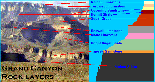
BTW not all aeolian dunes form in deserts. There are coastal aeolian dunes in both California and Oregon and along Lake Michigan and I am sure in many other places in the world. Now you also showed us a picture of the animal tracks in the Coconinos. You have also claimed that many layers below the Coconinos were flood deposited. These layers are nearly flat as you point out and extenisive over large areas. Will you please tell how these animals didn't all drown while the Tapeats Sandstone, Bright Angel Shale, Muav Limestone, Grand Wash Dolomites, Temple Butte Limestone, Redwall Limestone, Surprise Canyon Formation, Supai Group (Esplanade, Wescogame, Manakacha, and Watahomigie), and the Hermit Shale Formation were all deposited by the flood prior to the deposition of the Coconinos. Randy
|
||||||||||||||||||||||||||||||
|
roxrkool Member (Idle past 1007 days)  Posts: 1497 From: Nevada Joined: |
Pics of vegetation-stabilized dunes:
No webpage found at provided URL: http://www.geosciences.unl.edu/~dloope/BisonTracksWeb/bisonTracks.html White Sands National Monument dunes A quick summary of differences from HERE: -- Eolian dunes are generally over-steepened beyond the angle of repose (30-34 degrees), can be huge at 200+ meters, root casts, and mudcracks from dried up shallow pools of water. -- Water formed ripples and dunes are shallow dipping, rarely higher than 10-15 degrees, are no larger than several meters thick (atmosphere is a lot thicker than water is deep!), water ripples or dunes can contain planar beds when flow regime changes from low to high (eolian dunes do not!), anti-dunes can be formed under the fastest current conditions (I believe they do not form from eolian, but I need to check), silt ripples generally do not exceed several cm.
|
||||||||||||||||||||||||||||||
|
Percy Member  Posts: 22473 From: New Hampshire Joined: Member Rating: 4.7 |
Hi Peace,
The eolian versus aquatic deposition part of your post has already been addressed by others, so I won't add yet another reply on that topic.
Forces due to erosion do not produce a flat surface. Except for rivers and shorelines, with few exceptions erosion produces a very flat surface. Weathering is like a fine sandpaper gradually wearing down the highest points. The products of erosion, usually fine particulate matter but there can also be collapses and avalanches, find their way to the valleys where they accumulate. The mountains here in the north east are interspersed with many very flat valleys. Over time the mountains wear down and the valleys build up until you're finally left with a flat plain. However high the Coconino layers once were, however many layers once lay above the Coconino, they were all eroded away flat before the desposition of the Toroweaps. Unlike weathering, the erosion of rivers cuts through a landscape, precisely what we observe in a dramatic way at the Grand Canyon. The reason for the unusual depth of the cut is the gradual uplift of the region. The uplift was gradual enough for the river to have time to cut down through the layers. Had the uplift been sudden the Colorado would have diverted to a different course. --Percy
|
||||||||||||||||||||||||||||||
|
peaceharris Member (Idle past 5615 days) Posts: 128 Joined: |
In message 16,
Bill writes: The fact of the matter is that the cross-bedding of the Coconino Sandstone is of the wind-blown eolian type. For example, the Coconino Sandstone contains abundant climbing translatent beds created by wind ripples and grain-fall bedding produced by eolian grain-fall processes. Bill,To prove a theorem, you cannot use that theorem in your proof. In the same way, to prove that the Coconino sandstone is of eolian origin, you cannot state that the translatent beds are created by wind ripples and grain-fall bedding produced are by eolian grain-fall processes. If a person wants to argue for a submarine origin of the Coconino Sandstone, they need to explain why wind ripples, their climbing translatent beds, grain-fall bedding, and other types of bedding / sedimentary structures that can only form in terrestrial, eolian environments occur throughout it. Just because you call them 'wind ripples' doesn't make them eolian origin. If you are claiming that ripples, climbing translatent beds etc., can only form in terrestrial, eolian environments then you are not correct.
It's plain common sense that any footprint made in a eolian environment isn't going to last. In message 60,
Randy writes: The YECs never mention the fact that insect tracks and raindrop impressions are often found with the animal tracks and even the animal tracks could never have formed under water of sufficent depth and speed to deposit the Coconinos. Could you show me a photo of insect tracks raindrop impressions. Thanks. In message 63,
Randy writes: I suggest you look again at the pictures on your web site and the pictures the Roxrkool provide of aeolian sandstones. To prove that the cross bedded sandstones which Roxrkool believes to be of eolian origin, you cannot start with the assumption that these sandstones are indeed eolian origin. That's why I earlier asked for a photo of cross bedding which we know to be of eolian origin. The photo which you supplied was ripples. Ripples and cross beds are different. I had earlier supplied a photo of a crossbed from the saunton beach which is known to be of aquatic origin.
|
||||||||||||||||||||||||||||||
|
roxrkool Member (Idle past 1007 days) Posts: 1497 From: Nevada Joined: |
peace writes:
See message 64. Those are non-lithified modern eolian sand dunes.
To prove that the cross bedded sandstones which Roxrkool believes to be of eolian origin, you cannot start with the assumption that these sandstones are indeed eolian origin. That's why I earlier asked for a photo of cross bedding which we know to be of eolian origin. The photo which you supplied was ripples. Ripples and cross beds are different. I had earlier supplied a photo of a crossbed from the saunton beach which is known to be of aquatic origin.
|
||||||||||||||||||||||||||||||
|
Randy Member (Idle past 6265 days) Posts: 420 From: Cincinnati OH USA Joined: |
Could you show me a photo of insect tracks raindrop impressions. Thanks. Unfortunately the web page that had those pictures is no longer mainted. I am looking for some more. However, I have seen them as I sure others here have. You are the one who showed us the animal tracks. Please tell us how these animals were around to make tracks after the Tapeats Sandstone,Bright Angel Shale, Muav Limestone, Grand Wash Dolomites, Temple Butte Limestone, Redwall Limestone, Surprise Canyon Formation, Supai Group (Esplanade, Wescogame, Manakacha, and Watahomigie), and the Hermit Shale Formation were all deposited by the flood prior to the deposition of the Coconinos. It's plain common sense that these animals would have been dead long before the Coconinos were deposited and its plain common sense that these tracks could not have been preserved while 10,000 cubic miles of sand was being deposited on the animals making them. The explanation given for the tracks on the web page that is no longer with us was that the tracks were "fixed" by dew before the next sand storm buried and preserved them. The web page showed invertebrate tracks and features such raindrop impression that could only have been made in dry sand. Your beach sand ripples look quite different from the dry sand ripples I posted. Are you claiming that the Coconinos are beach sands? How would that work in a global flood? The idea the the Coconino sandstones were deposited by a global flood is refuted by their extenthttp://www.answersincreation.org/coconino.htm They are far too extensive to have been deposited in the short time allowable in the flood scenario, their structure, it is quite obvious to everyone who studies them with exception of the religiously motivated that they are aeolian and even some YECs realize this, and their trace fossils, some of the tracks and impressions could not have been made under water and there is no way there would have been any animals around to make them after all the lower flood layers were deposited. Randy
|
||||||||||||||||||||||||||||||
|
peaceharris Member (Idle past 5615 days) Posts: 128 Joined: |
Please tell us how these animals were around to make tracks after the Tapeats Sandstone,Bright Angel Shale, Based on my observations of the Grand Canyon photos, I have concluded that the tracks were made long before the Tapeats Sandstone and Bright Angel Shale formation. The tracks, were formed ~4500 years ago during a global flood. But the Tapeats Sandstone and Bright Angel shale, in my not so humble opinion, were formed in recent debris flows initiated by local rains. Photos show that these formations are at the bottom of the Canyon.
Look at the repeat photography of message 39. The photo taken in 1889. There are several large rocks at the left of the photo. But the photo taken in 1992 reveal clayey debris in the same location. Another line of evidence to prove that the sandstone and shale at the bottom of the Canyon is formed by recent rain is the fact that clayey particles are above the sandy ones. Rainwater will sort them this way. But the saline seawater during Noah's flood sorted the Coconino sands above the Hermit shale.
|
||||||||||||||||||||||||||||||
|
edge Member (Idle past 1724 days)  Posts: 4696 From: Colorado, USA Joined: |
Based on my observations of the Grand Canyon photos, I have concluded that the tracks were made long before the Tapeats Sandstone and Bright Angel Shale formation. That's an interesting observation, PH. If the tracks were formed earlier, how did the Tapeats and Bright Angel manage to slip under the Coconino? I guess you DO believe in miracles.
The tracks, were formed ~4500 years ago during a global flood. But the Tapeats Sandstone and Bright Angel shale, in my not so humble opinion, were formed in recent debris flows initiated by local rains. "... not so humble opinion..." is right! You are a troll, PH. Nobody is this stupid.
|
||||||||||||||||||||||||||||||
|
roxrkool Member (Idle past 1007 days) Posts: 1497 From: Nevada Joined: |
peace writes:
RECENT DEBRIS FLOWS?? You think those nicely layered SHALE and SANDSTONE formations are RECENT DEBRIS FLOWS? The tracks, were formed ~4500 years ago during a global flood. But the Tapeats Sandstone and Bright Angel shale, in my not so humble opinion, were formed in recent debris flows initiated by local rains. Photos show that these formations are at the bottom of the Canyon. You posted some pictures above... did you happen to see all that nice horizontally layered ROCK? Heck, you even posted a very nice picture of GREEN thin-bedded Bright Angel Shale. Why is it green you might ask? Glauconite. A mineral found ONLY in marine deposits.
Another line of evidence to prove that the sandstone and shale at the bottom of the Canyon is formed by recent rain is the fact that clayey particles are above the sandy ones. Rainwater will sort them this way. But the saline seawater during Noah's flood sorted the Coconino sands above the Hermit shale.
You're saying RECENT RAIN events sorted ~625 feet of ROCK? These formations are not unconsolidated loose sediments, Peace, they are solid rock. What you see in those photos is weathered rock. Besides, the Bright Angel Shale is not 100% clay particles, but also contains sandstone layers, as well as trilobites, brachiopods, mollusks, trackways, trails, and burrows. And you know what? That coarser grained material does not occur at the bottom of the formation where it should if it had indeed been water-sorted. Doesn't sound like any debris flow to me. I think, Peace, that you have reached the end of your geologic knowledge-base... This message has been edited by roxrkool, 05-13-2005 01:21 AM
|
||||||||||||||||||||||||||||||
|
peaceharris Member (Idle past 5615 days) Posts: 128 Joined: |
You're saying RECENT RAIN events sorted ~625 feet of ROCK? These formations are not unconsolidated loose sediments, Peace, they are solid rock. You shouldn't imagine that the rocks you see in the canyon represent the complete cross section of the plateau. The following image is a quartzite boulder compressing of sand laminae in basal Bright Angel Shale overlying Tapeats Sandstone:
The above photo is taken from MEGABRECCIAS: EVIDENCE FOR CATASTROPHISM If you asked me to interpret that photo, I will tell you that the quartzite boulder probably originated from the Coconino sandstone. But the reason why you find it along at the bottom of the canyon is due to erosion of the top layers by the river.
|
||||||||||||||||||||||||||||||
|
Minnemooseus Member  Posts: 3944 From: Duluth, Minnesota, U.S. (West end of Lake Superior) Joined: Member Rating: 10.0 |
From the bottom of the article you cite:
FRONT COVER. Basal Cambrian breccia in the Tapeats Sandstone at Ninetyone Mile Canyon in the Grand Canyon of the Colorado. Clasts of Precambrian Shinumu Quartzite sometimes greater than 15 m are found imbedded in the Cambrian sand matrix. I don't know enough about the area to make any further comment. Moose
|
||||||||||||||||||||||||||||||
|
peaceharris Member (Idle past 5615 days) Posts: 128 Joined: |
I cited that article merely because there was a photo which proved my point that the layers seen at the bottom of the Canyon is due to erosion of the top layers.
I do not share their view that it is precambrian Shinumu Quartzite imbedded in the Cambrian sand matrix.
|
||||||||||||||||||||||||||||||
|
Randy Member (Idle past 6265 days) Posts: 420 From: Cincinnati OH USA Joined: |
The tracks, were formed ~4500 years ago during a global flood. But the Tapeats Sandstone and Bright Angel shale, in my not so humble opinion, were formed in recent debris flows initiated by local rains. Just when I think that YECs can't get any more illogical something like this comes up. Not only are you contradicting geology and logic you are contradicting your own previous posts. Look back at the picture you posted on #27 and explain how the underlying layers were deposited by debris flows. Do you really think the layers below the Coconinos in this picture got in their levels by debris flow from local rains?
Fromhttp://www.kaibab.org/geology/gc_geol.htm Showing pieces of rock that have eroded and fallen down into the Canyon is not relevant to how the layers formed. The layers underlying the Coconino are laterally extensive layers of solid rocks of the Colorado plateau as anyone who known anything at all about Grand Canyon Geology knows. The site below has seimic survey showing this clearly but this has been know for a long time. Revisiting the Grand Canyon
Another line of evidence to prove that the sandstone and shale at the bottom of the Canyon is formed by recent rain is the fact that clayey particles are above the sandy ones. This is because they were deposited at different times and not by a single flood. You are confusing your interpretation with actual evidence.
Rainwater will sort them this way. But the saline seawater during Noah's flood sorted the Coconino sands above the Hermit shale. So how did animals make tracks in the Coconino sand that was being sorted from the Hermit shale (which are not actually shale but fine sands, mudstones and siltstones IIRC) by the salty waters of Noah's flood? Randy This message has been edited by Randy, 05-13-2005 08:47 AM
|
||||||||||||||||||||||||||||||
|
|
Do Nothing Button
Copyright 2001-2023 by EvC Forum, All Rights Reserved
![]() ™ Version 4.2
™ Version 4.2
Innovative software from Qwixotic © 2024