|

Understanding through Discussion |
|
|
Register | Sign In |
|
QuickSearch
Summations Only | Thread ▼ Details |
|
Member  Posts: 3945 From: Duluth, Minnesota, U.S. (West end of Lake Superior) Joined: Member Rating: 10.0 |
|
Thread Info
|
|
|
| Author | Topic: Continuation of Flood Discussion | |||||||||||||||||||||||||||||||||||||||||||
|
Percy Member  Posts: 22495 From: New Hampshire Joined: Member Rating: 4.9 |
Faith writes: The point I was making about the Claron had nothing to do with its elevation, the point was that it was deposited at the TOP of the stack of strata of all the "time periods" before it [--"on top of" those beneath it, even if there were once layers above it]. That was my point about the whole Geologic Column, that it IS found as a STACK, which is what makes it a model for ascending time periods and evolution of life, so that if it is now supposedly continuing to deposit at the bottom of the sea... You're describing two different locations. The Claron is one location, one stack of sedimentary layers. The bottom of the sea is a different location, a different stack of sedimentary layers.
... it is no longer a continuous stack,... Well, it both is and isn't a continuous stack, because even if they were once a continuous stack of layers stretching across a broad region, different parts of the stack will experience different tectonic forces. Consider this flat stack of layers:
_______________________________________________ _______________________________________________ _______________________________________________ _______________________________________________ _______________________________________________ And then one side uplifts and the other subsides to produce this:
____________________
____________________\
____________________\\
____________________\\\
____________________\\\\
                    \\\\\
                     \\\\\
                      \\\\\____________________
                       \\\\____________________
                        \\\____________________
                         \\____________________
\____________________ The forces of weathering erode the uplifted side, and the eroded material is carried by wind, rain, rivers and streams to the subsided side, forming additional layers:
____________________    ==> eroded material
____________________\\\
____________________\\\\
                    \\\\\______________________
                     \\\\\_____________________
                      \\\\\____________________
                       \\\\____________________
                        \\\____________________
                         \\____________________
\____________________ ...and it certainly is no longer accumulating fossils in the line of evolution. It most certainly is "accumulating fossils in the line of evolution." As the eroded materials forms sediments in the subsided region, deceased life will become buried and gradually fossilize. --Percy
|
|||||||||||||||||||||||||||||||||||||||||||
|
Percy Member Posts: 22495 From: New Hampshire Joined: Member Rating: 4.9 |
Let's address the last part first:
Faith writes: ABE: "Environments" enter the picture with the fossil contents of the rock. No. A sedimentary layer representing a past environment does not have to contain fossils.
Someone back there asked how I can reject the idea of stacked environments though accepting Walther's Law. All I can say is I don't see environments in the layers described by that model, just sediments that get laid down in a particular order. Consider this diagram again:
Sand is deposited immediately offshore in a sand environment such as a beach. It lithifies to sandstone. "Siliciclastic muds" are deposited further offshore in an environment consisting mostly of the runoff from land. It lithifies to sandstone, mudstone, siltstone and shale. "Carbonate sediments" are deposited far offshore in an environment of warm quiet seas and microscopic creatures whose skeletons comprise the vast majority of the layers. It lithifies to limestone. The material in sedimentary layers comes from the environments in which those layers were deposited. --Percy
|
|||||||||||||||||||||||||||||||||||||||||||
|
Percy Member Posts: 22495 From: New Hampshire Joined: Member Rating: 4.9 |
Faith writes: The deposition of any of those sediments doesn't necessarily take time although their formation may, and even there probably nowhere near as long as OE thinking assumes. There is no such thing as OE thinking, only evidence-based thinking. There's nothing particularly appealing about the concept of an ancient Earth other than that all the evidence says the Earth is ancient. We assume nothing. The processes we observe today depositing sedimentary layers are very slow. At a rate of say 4 cm/year it would take 40,000 years for a sedimentary layer to accumulate to a depth of a mile. Also, radiometric dating confirms that the layers are ancient and mostly formed slowly. The tiny particle size comprising the sedimentary layers require that they formed slowly, because it takes a great deal of time for tiny particles to fall out of suspension in even quiet water.
Beach sand is not created on the beach, it's created by tossing in the water and then it's deposited on the beach. I should have provided more detail about how beach sand is produced. Beach sand is produced by weathering forces, mostly on land. The forces of weathering carry eroded material to the lowest point, usually lakes and seas. The most energetic water exists at the interface between land and water in the form of waves. Only the larger and denser materials from land can deposit in an energetic environment, which would be sand. The smaller and lighter particulates are carried further out from shore and are deposited as siliciclastic muds. --Percy
|
|||||||||||||||||||||||||||||||||||||||||||
|
Percy Member Posts: 22495 From: New Hampshire Joined: Member Rating: 4.9
|
Faith writes: If we find out where, say, the GC was on that animation would it correspond to the kind of environment determined for the rock in that era? Or might it for instance possibly be located near the North Pole when the rock information says Tropical Sea? The latitude and rotational orientation where a rock formed on the globe is determined by the magnetization of the rock. The direction of the magnetic field leaves a trace magnetization in the rock at the time that it forms. The world has passed through both warmer and colder eras. The presence of a tropical sea at the North Pole has likely happened before and will happen again. About all the crashing and bashing you were talking about before, continental plates *do* collide. The Himalayas resulted from the collision of India with Asia. But the Grand Canyon is a long way from any plate boundaries, and it is at plate boundaries that tectonism is most active. --Percy
|
|||||||||||||||||||||||||||||||||||||||||||
|
Percy Member Posts: 22495 From: New Hampshire Joined: Member Rating: 4.9
|
After reading through the discussion of the past 24 hours I can only echo Moose's comment from Message 989: "Boggled."
If I responded to everything you said that I could make no sense of I would be here all day, so I'll just ask about this:
Faith writes: Yes, I do not see how the sediments deposited at the mouths of rivers have anything whatever to do with the Geological Time Scale. That is a done deal, a very specific stacking of sediments to an incredible depth that has come to an end. This sounds like you're saying that sedimentation at the mouths of rivers has come to an end and is no longer taking place. Do I understand you correctly? Or are you just saying that deltas we find buried within a sedimentary stack are no longer receiving sedimentation (which would make sense since they're buried)? Edge has been describing how both erosion and sedimentation are taking place all the time. Uplifted regions are being eroded at the same time that low lying regions are receiving deposits of the eroded material from uplifted regions. Uplifted regions are getting lower as the material comprising them is eroded away, and low lying regions are getting higher as sediments are deposited upon them. In an uplifted region that is being eroded away, such as the Claron with its hoodoos, the geological column is gradually disappearing. Someday the Claron will be gone and there will be no remaining explicit physical record of its existence. But in low lying regions sedimentary material is being deposited and there the geological column is gradually growing, centimeter by centimeter, year after year. --Percy
|
|||||||||||||||||||||||||||||||||||||||||||
|
Percy Member Posts: 22495 From: New Hampshire Joined: Member Rating: 4.9 |
Hi Faith,
There's been a lot of discussion since my last visit, so I'll just address points that are still under discussion.
Faith writes: No, it's the Geological Time Scale that has come to an end. Yet time continues to march forward. Look at it mathematically. Today we say that the end of the Cretaceous when the dinosaurs went extinct was 65 million years ago. Ten million years from now we'll say that the end of the Cretaceous was 75 million years ago. By mathematical necessity, geologic time has not come to an end. Geological processes are very slow and long time periods are just a tick of the geologic clock. Once one looks further back in time than a million years the shortest tick of the geologic clock might be around 10,000 years. A human being lives only about 1% of a single tick of the geologic clock, and it can make geologic time seem unreal in the here and now, but nonetheless it still exists today and marches on into the future.
And can't possibly be represented in other sedimentation that is going on now because the time table ASCENDS, CLIMBS. Sediments are being deposited today atop sediments that are already present, and time marches forward, which is what I assume you mean when you say the time table "ASCENDS, CLIMBS." In other words, sediments are being deposited today as geologic time continues to march slowly forward.
Erosion has absolutely nothing to do with it. It came to an end because it came to an end and NOW it is being eroded in all those places. Erosion never came to an end in any world-wide sense. Uplifted regions will always erode, and low lying regions will always receive the sediments eroded from uplifted regions.
Oh well, there is a vested interest here in thinking it continues so there's no hope of demonstrating this obvious fact that it's come to an end I guess. The only thing that's obvious is the complete lack of any evidence that erosion ever came to an end, plus the simple impossibility of it. All elevated regions are exposed to weathering which will erode them. Only a suspension of the laws of nature could bring erosion of an elevated region to an end. --Percy
|
|||||||||||||||||||||||||||||||||||||||||||
|
Percy Member Posts: 22495 From: New Hampshire Joined: Member Rating: 4.9 |
Faith writes: Exactly. The Claron is part of the Geo Time Scale, the other location is not. It would have to deposit ON the Claron to be that. The geology of the entire world is measured by the geologic time scale. This includes the elevated Claron Formation and it includes deeply submerged sedimentary layers beneath the sea. And each little region of the world contains its own unique geologic column containing a record of the sediments deposited there, and of the life that lived within and upon it when each layer took its turn at the surface.
Well, it both is and isn't a continuous stack, because even if they were once a continuous stack of layers stretching across a broad region, different parts of the stack will experience different tectonic forces. Which will not in any way affect the continuousness of the stack itself, just require reconstructing it. Just for completeness let me mention that tectonic forces can cause faults which *will* interrupt the horizontal continuity of stratigraphic layers, but the simple case I have in mind is simple uplift and subsidence with no faults to interrupt the horizontal continuity beyond introducing a slope and changes in elevation. And so we end up with something like this (keep in mind that the vertical scale is greatly exaggerated):
____________________
____________________\
____________________\\
____________________\\\
____________________\\\\
                    \\\\\
                     \\\\\
                      \\\\\____________________
                       \\\\____________________
                        \\\____________________
                         \\____________________
\____________________ [unable to get the illustration to reproduce correctly here.] Click on "peek" to see how it is done. The elevated portion erodes and sediments from it are deposited on the subsided portion:
____________________    ==> eroded material
____________________\\\
____________________\\\\
                    \\\\\______________________
                     \\\\\_____________________
                      \\\\\____________________
                       \\\\____________________
                        \\\____________________
                         \\____________________
\____________________ And you now ask:
Interesting hypothesis, haven't seen such a thing in reality, have you? Both sides having the same sequence of layers, the higher getting eroded down quite a bit and its eroded material neatly arranging itself in flat layers on the other side? A fine example is where the layers beneath Texas extend out into the Gulf of Mexico. The border between Oklahoma and Texas is on the left, the Gulf of Mexico coastline is on the right. The layers become more and more deeply buried as one moves toward and into the Gulf of Mexico. Sediments are being deposited today atop the layers already present in the Gulf of Mexico:
For one thing you'd be getting the same sediments being deposited again on the lower side. If more than one layer erodes you'll get the sediments from all those depositing over the same sediments on the lower side. Are they going to maintain their layered formation; wouldn't they just pile up and jumble up? Erosion will be uneven and will include contributions from different sedimentary layers. At the coastal margin between land and sea the runoff from land will be sorted a la Walther's Law into sand, silt, mud, clay, and further out to sea carbonates (eventually limestone) and mid-ocean ooze.
I was thinking of the layers at the bottom of the ocean that are not continuous with the layers of the Geo Column. They are very likely continuous horizontally for thousands of miles up until the sea's margins and oceanic ridges, and they are continuous with the vertical stack of layers beneath them. Seafloor sedimentary layers will not be horizontally continuous with terrestrial layers because there can be no oceanic sedimentation where there is no ocean. Exceptions occur for periods when seas encroach onto land, as we see increasingly happening today, and when sea floor is uplifted so that part of it becomes terrestrial. --Percy Edited by Percy, : Minor clarification.
|
|||||||||||||||||||||||||||||||||||||||||||
|
Percy Member Posts: 22495 From: New Hampshire Joined: Member Rating: 4.9
|
Hi Faith,
You had a series of messages from Message 1097 to Message 1102. This single reply addresses all of them.
Faith in Message 1097 writes: I'm too used to "Geologic Column" to change to "geologic section" or "the geology of the location". Don't see why there should be a problem. It refers to the physical strata. The important point that Moose and Edge and everyone are trying to get across to you is that the geologic column is not indefinitely continuous horizontally. Each local region has its own unique environment, and the sediments deposited in each one will reflect that uniqueness. Adjacent regions will tend to have similar environments, and so the geologic stack of sediments in those adjacent regions will also tend to be similar, but the further apart regions become the more different will be their geologic stacks. This is precisely what we observe. For example, the geologic stack in regions further and further from the Grand Canyon's geologic stack resembles it less and less.
Faith in Message 1098 writes: But we aren't in the Pleistocene and there won't be anything after the Holocene. Holocene is Greek for "entirely recent". It refers to the current geological era, and sedimentary layers are being deposited now in this era. At some point in the distant future geologists will choose a new name to refer to their current geological era. They'll refer to the sediments being deposited today as Holocene, and to the layers being deposited in their own time by the new name. So of course there will be geological eras after the Holocene.
I think this is apparent in the fact that the time periods are constructed on the upward climb of the strata and there aren't going to be any more strata. Now you're just denying simple reality. Sediments are being deposited and forming new strata every second. This is true in lakes and oceans everywhere, and in some terrestrial low lying regions. There can be no doubt that new strata are forming. Global warming will cause sea transgressions in low lying regions all around the world. Florida is one of the most vulnerable regions. Here's a map showing in red those parts of Florida that could be under water within a century or two:
The transgressing sea will follow Walther's Law and deposit at each location in turn first sand, then silt/mud/clay, then deeper water oozes. Just as we add to history every day, we also add to sediments and geologic time every day.
Faith in Message 1099 writes: If sedimentation is continuing on the bottom of the ocean it is NOT "continuing upward. In what other direction could it go if not upward?
Time can't stop continuing upward and onward of course but sedimentation obviously can and does. Well, of course sedimentation will cease if a region becomes uplifted and becomes an area of net erosion, but lakes and seas are regions of net sedimentation. Where do you think the products of erosion are going today? They're not evaporating into thin air. They're being deposited in low lying areas, mostly under water.
If it isn't building on the existing Geologic Column then the column has ended, and so has the Geo Time Scale. Every region of the world, whether atop Mount Everest or at the bottom of the Mariana Trench, is a geologic column. It may be a stack of layers, or it may be bedrock, but each area, whether on a mountain top or at the bottom of the sea, has its own unique geologic column. Areas that are low lying or submerged are having sediments added atop their growing geologic column. Areas that are elevated are being eroded and their geologic column is gradually shrinking. --Percy
|
|||||||||||||||||||||||||||||||||||||||||||
|
Percy Member Posts: 22495 From: New Hampshire Joined: Member Rating: 4.9 |
Faith writes: If you want to prove me wrong you are going to have to show me a place where the strata are that complete WITHOUT erosion and distortion after they were all in place but continue to build by placid deposition. I'm betting there is no such place on Planet Earth. I already gave you one example of such a place in Message 1095 where I included this image:
The sedimentary layers beneath Texas extend out into the Gulf of Mexico. Texas is an area of net erosion, while the Gulf of Mexico is an area of net deposition atop a stack of geologic strata. Faith, even a region that is just bedrock above mantle is a geologic column. Anything that deposits upon it adds to the geologic column at that location. These are simple concepts that follow from a mere definition of the terms. --Percy
|
|||||||||||||||||||||||||||||||||||||||||||
|
Percy Member Posts: 22495 From: New Hampshire Joined: Member Rating: 4.9 |
Faith writes: If sedimentation is not adding to THE UPPERMOST SURFACE OF IT then that sedimentation is not the Geologic Column. Rest assured that what everyone here has been saying all along is that sedimentation always adds to "THE UPPERMOST SURFACE" of the geologic column. Welcome to the club.
Actually that diagram does not show any sedimentation that is not already labeled by the Geo Time Scale...Anyway your diagram is composed of strata labeled by known time periods and shows no sedimentation that has accumulated since the most recent there. The diagram shows land extending from Oklahoma to the Texas coastline with the Gulf of Mexico. There won't be any current sedimentation on land because it is subject to weathering and is an area of net erosion. The sedimentation is taking place in the waters that begin at the coastline, which is underlain by the same layers of the geologic column that underlie Texas. The layers underlying Texas in the diagram extend out into the Gulf of Mexico, and sedimentation occurs atop those layers in the Gulf:
I wish the diagram included the Gulf instead of stopping at the coastline, but it is well known that the Gulf is accumulating sediment from runoff from land at a prodigious rate. But if you'd like evidence of sedimentation in the Gulf it should be easy to come by. --Percy
|
|||||||||||||||||||||||||||||||||||||||||||
|
Percy Member Posts: 22495 From: New Hampshire Joined: Member Rating: 4.9 |
The term "identifiable geologic structure" seems to be a very important requirement for you before you'll consider a sedimentary layer to be part of the geologic column, but geology has no such requirement. Geology will always consider any sedimentary layer or geologic structure to be part of the geologic column, whether we can identify it or not.
Horizontality during deposition is also not a requirement for sediment to contribute to the geologic column. Any sediment accumulating anywhere in the world in any orientation will always be considered to have added to the geologic column. --Percy
|
|||||||||||||||||||||||||||||||||||||||||||
|
Percy Member Posts: 22495 From: New Hampshire Joined: Member Rating: 4.9 |
Hi Faith,
Were this region of the world to sink beneath the waves and become a region of net deposition:
Then after a few million years of sedimentation it might look something like this and form an angular unconformity:
The bottommost new layer should actually conform to the topology of the surface landscape upon which it was deposited, but I'm using Microsoft Paint, and using that tool to draw at that level of detail would have taken more time than I have, so just imagine that it conforms to the current landscape, just like diagrams of unconformities at the Grand Canyon. The new sedimentary layers would be considered by geologists to be part of the geologic column, and they would exist within the geologic time scale. --Percy
|
|||||||||||||||||||||||||||||||||||||||||||
|
Percy Member Posts: 22495 From: New Hampshire Joined: Member Rating: 4.9 |
Faith writes: That's very clever and probably the only answer that at least superficially challenges what I'm saying. I do agree that Dr Adequate is very clever, and not to take anything away from him, but Dr A only provided the answer geology uncovered centuries ago by examining the evidence. It isn't anything novel, except maybe to you.
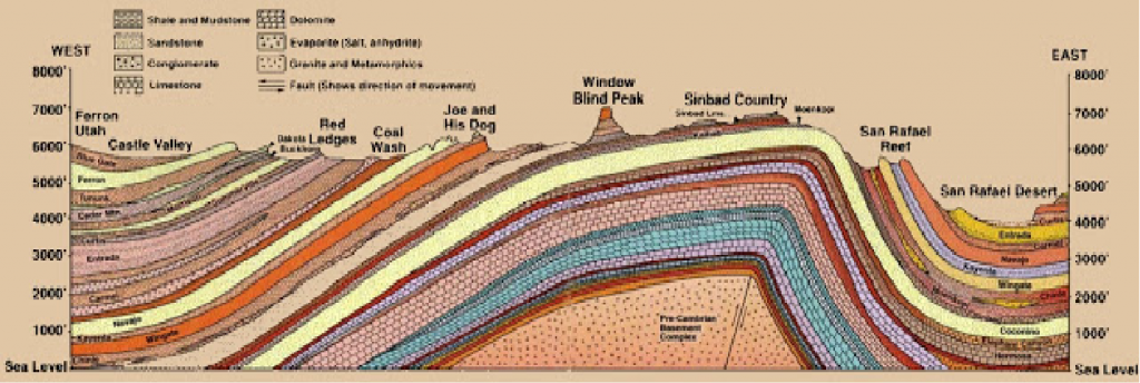
The thing is if a deposition did occur over that formation it would fill in the valleys and I haven't ever seen an angular unconformity in which the upper layers were anything but straight and flat both top and bottom, have you? Deposited sediments will always conform to the surface of the landscape, and a number of diagrams and images have been presented during these geology discussions that show an irregular surface between one layer and the next, i.e., an unconformity. Your favorite diagram is at a huge scale but nonetheless includes an example:
Look at the top surface of the rightmost of the two angular uncomformities with the Grand Canyon supergroup. The Tapeats and the Bright Angel Shale have both been deposited around the bulge of the Shinumo layer of the supergroup. The layers did not deposit up the sides of the Shinumo because as a prominence on the landscape it would have been an object of net erosion.
Also the upper layers occur over tightly folded lower layers, I've never seen one form over the kind of base in that diagram, have you? In theory that could happen but in reality there's no evidence that it ever does that I know of. Perhaps you can find some but I doubt it. Why do you only think it could happen in theory? If the region shown in this diagram were to become submerged:
Then whatever do you imagine would prevent sediments from filling it in? The lowest levels would be filled in first, then the rest, and eventually there would be a flat layer of sediment covering everything. --Percy
|
|||||||||||||||||||||||||||||||||||||||||||
|
Percy Member Posts: 22495 From: New Hampshire Joined: Member Rating: 4.9 |
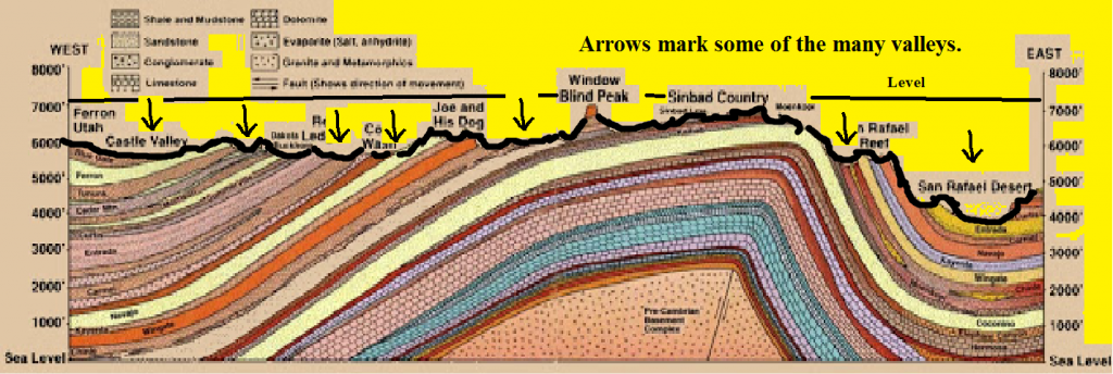
edge writes: That's very clever and probably the only answer that at least superficially challenges what I'm saying. The thing is if a deposition did occur over that formation it would fill in the valleys ...
What valleys? I see no valleys in the picture. If we're talking about this diagram:
Then I think she's referring to the right hand side. She's trying to say that there are no examples of sediments filling in a valley. --Percy
|
|||||||||||||||||||||||||||||||||||||||||||
|
Percy Member Posts: 22495 From: New Hampshire Joined: Member Rating: 4.9 |
Hi Faith,
Thanks for this image - Microsoft Paint just wasn't up to it:
So yes, the sediments will fill in all the irregularities of the landscape, the lowest points first, because sediments will run downhill from the higher points of the landscape. And as Edge pointed out, a slowly transgressing sea will erode the landscape and even out its features. But a sea that rises fast enough will leave in place very dramatic features, as we see here in this image of the Hudson Canyon south of Long Island. The most dramatic parts of the canyon are in the lower right quadrant:
The Hudson River formed this undersea canyon when glaciers covered much of North America, but then the glaciers melted, sea levels rose, and now this ancient canyon is gradually filling in with sediment and adding to the geologic column. --Percy
|
|||||||||||||||||||||||||||||||||||||||||||
|
|
Do Nothing Button
Copyright 2001-2023 by EvC Forum, All Rights Reserved
![]() ™ Version 4.2
™ Version 4.2
Innovative software from Qwixotic © 2024