
|

Understanding through Discussion |
|
|
Register | Sign In |
|
QuickSearch
| Thread ▼ Details |
|
Suspended Member (Idle past 1463 days)  Posts: 35298 From: Nevada, USA Joined: |
|
Thread Info
|
|
|
| Author | Topic: Glenn Morton's Evidence Examined | |||||||||||||||||||||||||||||||||||||||
|
edge Member (Idle past 1725 days)  Posts: 4696 From: Colorado, USA Joined: |
I know you said that "The other points apply as well," but this argument about underground river systems has come up before in multiple threads, and in this latest incarnation I'd like to make sure that geology's position is made absolutely clear. To that end I'd like to see the "other points" woven together with the point about dendritic patterns. I'll attempt this one myself, but I don't want to make too much a habit of making arguments as moderator.
Sure. River systems only form subaerially over long time periods because: Dendritic patterns only form subaerially. They represent the collection of increasing amounts of water descending from higher elevations across an existing landscape, a circumstance not found underground where fracture and stratigraphic patterns form a trellis pattern. Dendritic patterns are not found in aqueous environments, nor in karst (cave) structures. If you have a canyon, it is usually eroding downward and widening laterally. This is not sustainable underground because you have to have a roof which will eventually collapse and it won't be underground any more.
The wearing away of even just millimeters of rock by the continuous flow of water takes years at a minimum. Observing the flow of rivers and streams over a lifetime makes this clear. Even the incredibly energetic Niagara Falls cut back at only about three feet per year through limestone before engineering efforts slowed the erosion. Heavy sediment loads can increase erosion rates, but solid rock makes scarce contributions to sediment.
No problems.Please correct/expand as necessary. Edited by edge, : No reason given.
|
|||||||||||||||||||||||||||||||||||||||
|
jar Member (Idle past 413 days)  Posts: 34026 From: Texas!! Joined: |
One thing that might have an influence is the material involved. It's possible, likely even to find underground structures that might look like a river valley system if talking about a limestone structure but far less likely if looking at a layer of sandstone I would think. A second indicator might be the presence of two or more different materials showing a change in deposition.
|
|||||||||||||||||||||||||||||||||||||||
|
edge Member (Idle past 1725 days) Posts: 4696 From: Colorado, USA Joined: |
One thing that might have an influence is the material involved. It's possible, likely even to find underground structures that might look like a river valley system if talking about a limestone structure but far less likely if looking at a layer of sandstone I would think.
Sure, they may look like river valleys, but they are still controlled by fractures and I know of no fracture pattern that is dendritic in morphology. Now if you had a trellis pattern, possibly, but you still have the problem of getting a roof to stand. The other factor is time, of course, because these things don't just happen over night.
A second indicator might be the presence of two or more different materials showing a change in deposition.
Not sure how that would happen unless you are no longer talking about forming a valley/canyon.
|
|||||||||||||||||||||||||||||||||||||||
|
Admin Director  Posts: 13014 From: EvC Forum Joined: Member Rating: 1.9 |
edge writes: We do not see such patterns that formed underground. We see them underground, but not necessarily formed underground. Right - and how do we know they didn't necessarily form underground? You answer the question yourself:
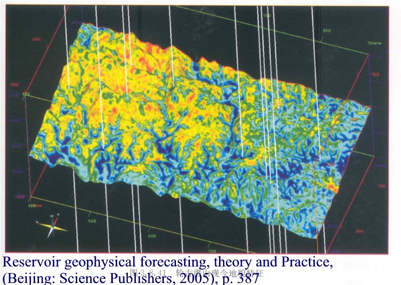
If you find one that is formed underground we should look at the data. Right. So here are the two images offered so far:
What is the data that tells us these formed subaerially and not underground?
|
|||||||||||||||||||||||||||||||||||||||
|
Admin Director Posts: 13014 From: EvC Forum Joined: Member Rating: 1.9 |
edge writes: One thing that might have an influence is the material involved. It's possible, likely even to find underground structures that might look like a river valley system if talking about a limestone structure but far less likely if looking at a layer of sandstone I would think.
Sure, they may look like river valleys, but they are still controlled by fractures and I know of no fracture pattern that is dendritic in morphology. If I find this confusing, others might, too. If they're not dendritic, and if dendritic is what tells us they're river valleys, then why might they look like river valleys? Also, and this is a question for Jar, too, since it comes from his post, why is a limestone structure more likely to "look like a river valley system" than a structure of the much harder sandstone?
|
|||||||||||||||||||||||||||||||||||||||
|
jar Member (Idle past 413 days) Posts: 34026 From: Texas!! Joined: |
edge writes: jar writes:
Not sure how that would happen unless you are no longer talking about forming a valley/canyon. A second indicator might be the presence of two or more different materials showing a change in deposition. I am talking about detecting buried structures. If a river valley then gets filled in by another layer there is a likelihood that the material filling in the valley can be differentiated from the material that formed the original valley and that it will extend beyond the limits of the valley and over the surrounding original material. This could not happen underground and is an indication that what is seen was formed at the surface.
|
|||||||||||||||||||||||||||||||||||||||
|
jar Member (Idle past 413 days) Posts: 34026 From: Texas!! Joined: |
admin writes: Also, and this is a question for Jar, too, since it comes from his post, why is a limestone structure more likely to "look like a river valley system" than a structure of the much harder sandstone? Limestone can be dissolved by water following small cracks fairly rapidly. Sandstone is not dissolved by water and in fact the water is likely to leach out minerals and deposit minerals increasing cementation.
|
|||||||||||||||||||||||||||||||||||||||
|
edge Member (Idle past 1725 days) Posts: 4696 From: Colorado, USA Joined: |
Right. So here are the two images offered so far:
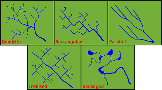
Just from the images, the size of the valleys (no supportable roof, therefore, not underground) and the apparent lack of control by fractures (as cave systems are ,,, remember the Lechuguilla Cave diagram). What is the data that tells us these formed subaerially and not underground? Beyond that there is probably other evidence available in the geological logs such as evidence for mechanical erosion (as opposed to chemical solution of limestone), Oxidation effects on a paleosurface, certain fossil data (I imagine), etc. One thing that I have avoided for purposes of this discussion is the observation that dendritic patters evolve on surfaces with little geometric anisotropy. In other words, no fractures, folds, intrusions, etc. Such things would cause an anisotropic gradient that would be reflected in stream patterns. For instance, this diagram shows various geometries imposed by geological structure on a stream pattern. The upper left is a dendritic pattern for comparison. As you can see these patterns are visually distinct.
ETA: I should probably add that the more structurally controlled patterns can form underground. The dendritic pattern, however, would be hard to visualize happening. However, what we are looking at in the Glennn Morton example is dendritic. Edited by edge, : No reason given.
|
|||||||||||||||||||||||||||||||||||||||
|
edge Member (Idle past 1725 days) Posts: 4696 From: Colorado, USA Joined: |
Limestone can be dissolved by water following small cracks fairly rapidly. Sandstone is not dissolved by water and in fact the water is likely to leach out minerals and deposit minerals increasing cementation.
Yeah, there aren't too many large sandstone caves.
|
|||||||||||||||||||||||||||||||||||||||
|
edge Member (Idle past 1725 days) Posts: 4696 From: Colorado, USA Joined: |
I am talking about detecting buried structures. If a river valley then gets filled in by another layer there is a likelihood that the material filling in the valley can be differentiated from the material that formed the original valley and that it will extend beyond the limits of the valley and over the surrounding original material. This could not happen underground and is an indication that what is seen was formed at the surface.
Okay, I get it. Edited by Admin, : Fix quote.
|
|||||||||||||||||||||||||||||||||||||||
|
herebedragons Member (Idle past 876 days)  Posts: 1517 From: Michigan Joined:
|
Don't know what you mean "tie Carboniferous formations together." Isn't most identification possible through fossils and the order of the layers/ What makes Carboniferous formations 'Carboniferous'? In traditional geology, Carboniferous formations were all deposited during the same time period. They are all related by the time period in which they were formed. What makes Carboniferous formations related to one another according to YEC thinking? Nothing. What makes them in the "right" order? What makes Carboniferous formations always come after Devonian formations and why should they? If you are only looking at the order of layers, what do you do when layers are "missing"? If you are only counting layers and considering the order they are in, why would you ever consider a layer to be "missing"? In other words, why are there no Ordovician or Silurian deposits in the Grand Canyon?
But there is an observable pattern that a YEC can't deny even if there is no way to explain it by the Flood: simply studying the rocks, knowing that the fossils occur in a certain order, which a Floodist could ascertain as well as anyone else, -- aren't these the ways the rocks are identified? A YEC would be looking at the physical arrangement under relative dating. So in other words, a YEC geologist would use traditional methods and just deny the old ages. OK, but the problem is that traditional methods don't fit within a global flood paradigm. It's not just a matter of speeding the processes up 100,000,000 times, but it is completely throwing out traditional explanations. If that is the case, then using traditional methodologies simply could not work. Instead what you do is say we can use traditional methodologies but simply reject the implications of those methodologies. It's not about the absolute ages, per se, but about methods. What methods would a YEC employ that are different than traditional geologists? The same methodology, you say? There is just no way that the same methodology would work for two diametrically opposed theories. Just no way.
Floodists can see the order of the rocks and the fossils as well as anybody else and those ought to be sufficient to guide a person to the right location. Again, it would take someone who had studied the rocks to know where to look for those kinds of rocks where oil would be found. So you might think. But science requires prediction and testing - not just to be considered science, but it needs those things in order to function. Floodology cannot produce valid predictions; instead it would have to rely on the predictions and discoveries of traditional science. I know you don't see the significance of this, but prediction and theory are vital to scientific discoveries. A theory that posits a global flood that deposited ALL the sedimentary layers in less than a year CANNOT make the same predictions as a theory which posits gradual accumulation over long periods of time. They just cannot make the same predictions about anything geological. And yet, that is what you are claiming here; that flood geology and traditional geology would make the same predictions about where they would find oil. Worse than that even, you claim that traditional geology is completely bogus and yet you would propose to use traditional geological methods in the name of YEC to make discoveries. It's really quite unworkable. HBDWhoever calls me ignorant shares my own opinion. Sorrowfully and tacitly I recognize my ignorance, when I consider how much I lack of what my mind in its craving for knowledge is sighing for... I console myself with the consideration that this belongs to our common nature. - Francesco Petrarca "Nothing is easier than to persuade people who want to be persuaded and already believe." - another Petrarca gem. Ignorance is a most formidable opponent rivaled only by arrogance; but when the two join forces, one is all but invincible.
|
|||||||||||||||||||||||||||||||||||||||
Faith  Suspended Member (Idle past 1463 days) Posts: 35298 From: Nevada, USA Joined: |
The Carboniferous would be related to the Carboniferous by its physical characteristics and fossil contents. There is no "time period" you can point to in any case, that's purely hypothetical.
AS I said, the fact is that there IS an order to them, and why is irrelevant. To identify a particular layer only requires knowiong its physical characteristics. And OE Geology does not own science or any scientific facts. They belong to all of us. Whatever is true is mine as well as yours.
|
|||||||||||||||||||||||||||||||||||||||
|
Taq Member  Posts: 10028 Joined: Member Rating: 5.3 |
Faith writes: The Carboniferous would be related to the Carboniferous by its physical characteristics and fossil contents. What physical characteristics identify a strata as being from the Carboniferous? Edited by Taq, : No reason given.
|
|||||||||||||||||||||||||||||||||||||||
|
herebedragons Member (Idle past 876 days) Posts: 1517 From: Michigan Joined:
|
The Carboniferous would be related to the Carboniferous by its physical characteristics and fossil contents. There is no "time period" you can point to in any case, that's purely hypothetical. The time period is how traditional geology ties all Carboniferous formations together, hypothetical or not. You say they are linked by their physical properties and fossil contents? So what physical properties do all Carboniferous formations have in common that distinguish them from other types of deposits? And fossil contents you say? Your hypothesis is that the dead things were deposited based on their original location as when you state...
Faith writes: different original locations of the different fossil groups, seems to me to be the best explanation. Are all Carboniferous fossils in the same group? And what properties do Carboniferous fossils have that allow you to identify them as a group? If you don't have a way to group the fossils together, then it doesn't make sense to group Carboniferous strata together based on fossils.
AS I said, the fact is that there IS an order to them, and why is irrelevant. To identify a particular layer only requires knowiong its physical characteristics. Again, what are the physical characteristics of Carboniferous layers? How do those characteristics differ from Permian layers? What is about them that makes them group together and be identifiable as 'Carboniferous'?
And OE Geology does not own science or any scientific facts. They belong to all of us. Whatever is true is mine as well as yours. Don't know what you mean here. I didn't say anything about "OE geology" owning anything. What I am saying is that you can't use traditional geology's explanation for why Carboniferous deposits are in fact 'Carboniferous' and reject the explanation at the same time. Geologists group Carboniferous formations together because they were deposited during the same era; and they use several methods to determine what era they belong to including radiometric dating, index fossils, marker horizons and paleomagnetism. You claim that you can use the same methodologies while simultaneously rejecting all the reasons for using those methodologies. Doesn't make sense. HBDWhoever calls me ignorant shares my own opinion. Sorrowfully and tacitly I recognize my ignorance, when I consider how much I lack of what my mind in its craving for knowledge is sighing for... I console myself with the consideration that this belongs to our common nature. - Francesco Petrarca "Nothing is easier than to persuade people who want to be persuaded and already believe." - another Petrarca gem. Ignorance is a most formidable opponent rivaled only by arrogance; but when the two join forces, one is all but invincible.
|
|||||||||||||||||||||||||||||||||||||||
|
Faith Suspended Member (Idle past 1463 days) Posts: 35298 From: Nevada, USA Joined: |
I maybe read the wrong page but I'll comment on it anyway, the one about the termiites and cicadas.
there are cicada burrows as well. And since cicadas take 13 years to fulfill their life cycle, it is difficult to see how this could fit into a global flood.! Here is a picture of the top of a cicada burrow. The blue arrow and half dollar show its location:
I read up on cicadas at Wikipedia and found out that it is only when they become nymphs that they burrow into the ground, the usual situation being that they fall out of the trees where they've been developing into nymphs and then burrow into the ground beneath the tree, where they live for many years on the roots that grow down into the burrows. In this description there is nothing about how long this phase takes, but it certainly doesn't seem like it would require much time, maybe just a few hours. But it also seems very odd that there would be only one burrow in that rock when normally the nymphs fall out of the trees in great numbers. Also there is no sign of any fossilized roots for it to live on. Seems to me if that is definitely a cicada burrow that the creature landed there by accident or trauma, burrowed into the sediment because that's what it does and then must have died soon after. Again, the situation here is a bare rock which is far more consistent with the Flood scenario than any scenario of normal life in a normal landscape. (to Admin, this topic does belong here with the Morton discussion although it also belongs on the other thread. When I get back to that thread I'll sum up some of what has come out here, but the emphasis there is the PROCESS of getting to the rock from the landscape, here it's just the fact of the existence of the rock.) As for the timing, I've been thinking in terms of tides depositing most or some of the sediments during the Flood and in that case there would be hours when the tide was out when all the impressions could have been made in the sediments that eventually became the strata. I know Morton is responding to the most common views of how the Flood occurred, but since nobody knows and it's all guesses, and there could have been many phases to it as well, some of my answers to him would be contradicting his understanding of the YEC position. I don't know if tides deposited much or any of the sediments, it just seems very possible and would allow the time needed for the impressions to be made as the Flood was in progress. It also seems there may have been a phase when sediment was precipitated out of more or less quiet water. But everything about how the Flood would have occurred is speculative. Also, the turbulence Morton often refers to as making common YEC ideas impossible, may only have been a phase of the Flood, probably right at the beginning when the heavy rain would have broken up the soil and brought about mudslides. And at the very end when strata breaking up would make gaps the water would rush into. I may go back to that page to ponder the termites, but my impression to this point is that I was expecting to see a whole termite mound somehow incorporated into the rock but there is only a very small place identified as termites, which suggests they too got there more or less by accident.
|
|||||||||||||||||||||||||||||||||||||||
|
|
Do Nothing Button
Copyright 2001-2023 by EvC Forum, All Rights Reserved
![]() ™ Version 4.2
™ Version 4.2
Innovative software from Qwixotic © 2024


 (1)
(1)
