|

Understanding through Discussion |
|
|
Register | Sign In |
|
QuickSearch
| EvC Forum active members: 66 (9164 total) |
|
| |
| ChatGPT | |
| Total: 916,472 Year: 3,729/9,624 Month: 600/974 Week: 213/276 Day: 53/34 Hour: 1/2 |
Summations Only | Thread ▼ Details |
|
Thread Info
|
|
|
| Author | Topic: Evolution. We Have The Fossils. We Win. | ||||||||||||||||||||||||||||||||||||||||||||||||||
|
Percy Member  Posts: 22480 From: New Hampshire Joined: Member Rating: 4.8 |
Minnemooseus writes: There is no info presented about how this slope retreat rate is calculated. See Web-based Interactive Landform Simulation Model -- Grand Canyon (WILSIM-GC) Parameters, also referenced in my Message 1171. It references an estimate of the average slope retreat based upon studies of animal droppings. There are other estimates, but they tend to be complicated because they pose variable rates of slope retreat as a function of time period and position along the canyon, e.g., Rates of river incision and scarp retreat in eastern and central Grand Canyon over the past half million years: Evidence for passage of a transient knickzone. --Percy
|
||||||||||||||||||||||||||||||||||||||||||||||||||
|
Percy Member Posts: 22480 From: New Hampshire Joined: Member Rating: 4.8 |
Faith writes: You do seem to make what to me is a small point into a huge problem and it just seems endless and impossible to find a way to explain something clearly to you. No one else accepts your explanations either.
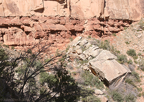
The contact as shown in that picture with the arrow is just one single line with no gaps, no erosion, just a single fine line. As I've said, there only seems to be that one short stretch where it is that tight. That's all I know. In the video Garner says there isn't even a smidgen of erosion or anything else in that contact. Geologists look at the Coconino/Hermit boundary and say its a disconformity. That means the top of the Hermit is eroded. The short 20-foot stretch contains no erosion channels, but other sections of the boundary do.
What Garner actually says is that at this location there's a very narrow layer (maybe an inch?) atop the Hermit Shale and beneath the Coconino called the Schnebly Formation. No he doesn't say that, Percy, please listen again. You're right, he doesn't say that. There are apparently no Schnebly Formation represented in the Grand Canyon, not even the inch I thought I saw in this image:
See that skinny layer at the top of the Hermit and bottom of the Coconino? It doesn't look like it belongs to either layer. I wonder what it is.
What he says is that in other parts of Arizona a very THICK layer called the Schnebly formation is found between the Coconino and the Hermit, which leads geologists to figure that there's about ten million years missing between the Coconino and the Hermit in the Grand Canyon although there is no evidence whatever of any deposition at all in the photo in question. Right. I didn't listen that far the first time, I listened for a full minute this time. I don't like videos because I read far faster than people talk.
ABE: You persist in claiming that your fields and plains and deserts are as straight and level as that contact? I don't get it. If the surface of the Hermit was exposed at that contact so you could walk on it, it would be like walking on a concrete sidewalk. Sure, of course - it's rock.
If you walked on the surface in any of your photos you'd strain your ankles because of the clods in the field and the similar unevenness of the other surfaces. I really don't get at all how you can make any comparison between these things. You're inventing things again. People have little trouble walking across flat landscapes. But any minor unevenness is irrelevant because I wasn't comparing those landscapes to the Hermit Shale. You claimed that erosion makes landscapes uneven, and those images show that erosion flattens and evens a landscape. You ignored most of the issues I raised, namely:
--Percy
|
||||||||||||||||||||||||||||||||||||||||||||||||||
|
Percy Member Posts: 22480 From: New Hampshire Joined: Member Rating: 4.8 |
Faith writes: The thought of trying to explain any of that to you gives me a stomach ache because if you don't get it by now I know I'm in for post after post of not being able to get you to see any of it no matter what I say. No one is "getting" anything you say. Most of it is either fantasy or just plain wrong. You're determined to keep God out of the Flood, but your ignorance of how nature actually works results in impossible ideas, and so they may as well be miraculous anyway.
I think the Kaibab uplift is the linch pin as it were of all the tectonic disturbance in the entire area as shown on that cross section. I think there was a big tectonic event that pushed up the Supergroup which pushed up the Paleozoic strata which caused cracks in the uppermost layers of the mile or two stack of layers above the Permian/Kaibab which then broke up and widened the cracks, which became the Grand Canyon. For convenience, here's your favorite diagram again:
When you call the Kaibab Uplift the "linch pin...of all the tectonic disturbance in the entire area", how could it have anything to do with the uplift at Cedar Break? How did the Supergroup layers tilt without affecting the layers immediately above, especially since the layers above had a lesser weight of layers upon them than the Supergroup and should have been easier to tilt or at least deform? How did the uplifting Supergroup layers cause the uplift of the Paleozoic layers to the immediate north of the Supergroup? Why do faults between the Supergroup blocks extend down into the Vishnu Schist but not up into the Paleozoic layers if the Paleozoic layers were already there when the tilting occurred? Where did all the cubic miles of missing material from the tilted Supergroup layers go?
The same tectonic event raised the southern end of the Grand Staircase up toward the top of the Kaibab uplift where the canyon was formed, and that lifting disturbed the strata in that area which broke off and formed the cliffs of the staircase. And the evidence that this isn't pure fiction is?
That same tectonic event triggered the volcano which sent the magma dike up from the basement through the strata to the top of the Grand Staircase at the very end and no doubt contributed to the general shaking that broke up the strata that made the cliffs of the staircase. What information (from the diagram or anywhere) tells you that the cause of the Kaibab Uplift and of the magma dikes were one and the same? What information tells you that the top strata of the Grand Staircase were broken up by "general shaking" causing geologic structures like the Pink Cliffs, the Grey Cliffs, the Vermilion Cliffs and the White Cliffs? The information we actually have tells us that the northern end of the Grand Staircase began eroding away with the uplift of the Colorado Plateau about 13 million years ago (see Geology of the Zion and Kolob canyons area). The uplift caused cracks in the strata which were opportunistically exploited by rivers such as the Virgin River. River flow in this region is episodic, being very light and slow much of the year but experiencing flash floods in the spring, hence canyon walls tend to be very steep because of rapid downcutting.
The Hurricane Fault occurred at the same time. What information tells you that the Hurricane Fault occurred at the same time as the general uplift of the Colorado Plateau, the Kaibab Uplift, and the magma dikes?
A lot of shaking going on in that whole area all at once. By shaking you mean earthquakes? What evidence are you looking at that tells you the region experienced earthquakes that caused the cracks and joints in the rock? How do you know the cracks didn't form gradually from tectonic strain? Since a very common cause of earthquakes is movement along fault boundaries, the faults have to already be there before the earthquakes.
I also figure the granite was formed at the same time, and the Vishnu schist. It's hard to understand what you're saying here. Is there a granite layer you're referring to that is not the Vishnu Schist? And how do you have the layers forming at the same time as the uplifts? Don't the layers have to be present before the uplifts and erosion, rather than forming at the same time they're being uplifted and eroded. The Paleozoic layers couldn't form before the Vishnu Schist below them, so how could they be uplifted and shaken and cracked before they even exist?
I spent a lot of time trying to decide where all this was occurring in relation to the Flood, figuring it had to be receding about that time and being the major force that washed away the strata in the staircase area leaving the cliffs, and in the canyon area washing down all those upper strata which carved out that huge space. I don't know if you realize it, but the way you've described everything has deposition of strata happening at the same time as uplift and cracking of strata and of erosion of the strata. The impossibility of this should be obvious.
Recently I started thinking that this tectonic event must have been the big one that split the continents and started the continental drift,... What evidence do you have that says a tectonic event in the Grand Canyon region was responsible for the splitting of the continents? The dating of the breakup of supercontinents like Gondwana, Laurasia and Pangaea do not correspond to the dating for the uplift of the Colorado Plateau or the Kaibab Uplift. Since there have been multiple supercontinents that broke up in Earth's history, which one are you imagining is the one that broke up?
...which in the Flood scenario would have started out a lot faster than the usual idea of its speed,... There is no evidence that the movement of tectonic plates has ever been outlandishly fast. The speeds of the various plates ranges from 1 to 10 cm/year.
...and gradually slowed over the last 4500 years to its present speed of I think less than an inch a year? I just provided the range of plate speeds. 2-3 centimeters per year is true of the North American Plate, but the Pacific Plate moves about 10 centimeters per year. There is no evidence that plate speeds have been dramatically different in the past than they are now - plate boundaries and sea floors provide copious evidence of plate speeds. Certainly speeds less than a centimeter per year are possible. Speeds greater than 10 centimeters per year are likely also possible, but not by a great amount, and certainly not the miles/day required in your flood scenario.
Then it seemed that had to be when the Flood waters began to recede after sitting quietly at their height for two months. What evidence and rational leads you to believe that rapid plate motion began when the flood waters began to recede?
Something happened on the sea floor and under the continents that broke them apart and caused the water to drain, began the Atlantic ridge, began volcanism which gets triggered with the movement of the continents and so on. Where is the evidence of this "something happened on the sea floor"? "Under the continents"? Water draining? That it caused the Atlantic ridge? Why do you think volcanism only began with the breaking up of the continents, since volcanic ash and magma is easy to date, those dates don't support your scenarios, and there is copious evidence of volcanism throughout Earth's history.
Obviously I don't accept much of the conventional thinking about all these things. You can be as unconventional in your thinking as you like as long as you have evidence for what you think and your scenarios obey known physical laws and aren't miraculous. --Percy
|
||||||||||||||||||||||||||||||||||||||||||||||||||
|
Percy Member Posts: 22480 From: New Hampshire Joined: Member Rating: 4.8 |
Faith writes: You should bring some of the evidence and argument from the film into the thread, or at least provide the time where each issue is addressed. I'd be especially interested in how Walther's Law is confirmed and how the fossil order is wrong.
I indicated where many of these things were presented in the film in Message 1140 Oh, I thought you were referring to something more than what you said in Message 1140. If that message is what you want to stand on, then concerning Walther's Law you said:
Faith in Message 1140 writes: From 4:55 he's showing sedimentation experiments in a flume in Colorado. This shows that strata form in moving water both vertically and laterally simultaneously, which is a confirmation of Walther's Law, and a challenge to the idea that strata form slowly by superposition. The flume stream in Bertault's experiment is a) nothing like a flood; and b) does something that is not part of Walther's Law, which is to build diagonal sediments laterally. In Bertault's experiments a flume of sediment laden water build strata laterally across his tank at an angle of around 45 degrees. Look at time 5:50 to see the slant of his strata. Does that look anything like what we find in the geologic record? . Does that look anything like Walther's Law to you? About fossil order you say:
Faith in Message 1140 writes: For instance in this Part 3 around 5:20 he shows how fossils are not deposited according to age but that an older one can be buried in a layer above a younger one. This has a major problem all by itself without even looking at the video. According to you all fossils are the same age. If Bertault is exploring a scenario where the fossils are of different ages then he does not share your views. And floods cannot sort by age or by difference from modern forms. Floods will sort by size, density and shape, plus in a flood there's a large random element. So if you dump fossils of different ages and forms into a flood they'll be sorted by size, density and shape. That means that an older fossil could end up above a younger fossil. It means that a fossil very different from modern forms could end up above a fossil very similar to modern forms. But nothing like that is ever found in the fossil record. --Percy
|
||||||||||||||||||||||||||||||||||||||||||||||||||
|
Percy Member Posts: 22480 From: New Hampshire Joined: Member Rating: 4.8 |
Faith writes: Why am I here? That wasn't really my question. My question contained important context that this ignores. My actual question was:
Percy in Message 1208 writes: I think we all have to wonder in amazement at your proclivity for introducing topics you find "intensely frustrating and boring," and that you continue subjecting yourself to "this annoying experience I want to end." If you find this all so disagreeable, why are you here? That's the question I asked. Rephrased, if discussion here upsets you so much, why don't you find something to do that you enjoy more and that makes you feel good?
Faith writes: It gives me an opportunity to figure out what I think that I don't find elsewhere. Thinking must be based upon knowledge of the real world and driven by evidence to have value. Your thinking is based on an eclectic personal interpretation of a religious book that you try to impose upon the real world. When you encounter disagreement it often makes you upset and unhappy. This causes you to say things like, "The thought of trying to explain any of that to you gives me a stomach ache," and "You do seem to make what to me is a small point into a huge problem and it just seems endless and impossible to find a way to explain something clearly to you." --Percy
|
||||||||||||||||||||||||||||||||||||||||||||||||||
|
Percy Member Posts: 22480 From: New Hampshire Joined: Member Rating: 4.8 |
I'm going to start with your last paragraph about whether the Coconino/Hermit boundary is really a disconformity:
edge writes: Finally, I have been trying to find out if anyone thinks that the Coconino/Hermit contact is an unconformity and I don't really see it discussed as such. If you have such information, I'd be interested in seeing it. I might call it a diastem, but I don't think it is a full-blown unconformity. I first saw it mentioned that the Coconino/Hermit boundary is a discontinuity at the Wikipedia article on the geology of the Grand Canyon area:
quote: I wasn't sure whether to trust this information, but then I found more information, and it addresses what you say about little of the Hermit Formation being lost to erosion:
The Cocnino/Hermit boundary is a discontinuity representing millions of years of erosion of the Hermit Shale and whatever now-lost layers were above it.
I really don't think it was that long and probably very little was lost. This is from The Grand Canyon Panorama Project: Hermit Shale:
quote: But obviously you think this is wrong, and I've read that the Hermit Formation is one of the least studied layers, so maybe you think this information shouldn't be trusted?
Further, it is thought that the cracks in the Hermit are actually mud cracks that were open when the Coconino sand began blowing across the drying mudflats. In many cases the cracks can be seen zig-zagging downward into the Hermit suggesting that there is compaction of the muds as it was loaded by the overlying sand mass or even later as the sediments piled up. Yes, thanks for mentioning this. I discovered I was wrong about this and was going to work it into an upcoming message, but this saves me the trouble. I thought I'd discovered evidence of tectonism, but no such luck. --Percy
|
||||||||||||||||||||||||||||||||||||||||||||||||||
|
Percy Member Posts: 22480 From: New Hampshire Joined: Member Rating: 4.8 |
You posted three replies to my Message 1215. I'll reply to them here in this message.
Replying to your Message 1216:
Faith in Message 1216 writes: See that skinny layer at the top of the Hermit and bottom of the Coconino? It doesn't look like it belongs to either layer. I wonder what it is.
If I'm seeing what you have in mind, it looks to me like a slight beveling of the Hermit rock just below the contact, that happens to be catching the light so it stands out. ABE: Now I'm wondering if you are talking about the contact we've supposedly been discussing all along, which is nothing but a fine line, very very straight and without any erosional channeling. That is what is "between" the layers but it is most certainly not a layer, it's the contact line. Okay, let's call it the contact line. It's about one inch thick. How is that a "knife-edge tight" boundary? Here's the image for reference:
Replying to your Message 1219:
Faith in Message 1219 writes: No one else accepts your explanations either. But nobody else is as confused about what I'm saying as you are. I think the only difference between me and everyone else is that no one else is pushing you as hard on this point. Pretty much no one accepts your explanations.
However, the general paradigm blindness here is indeed what makes my efforts nightmarish, and my constant hope that somebody will finally be smart enough or honest enough to get it is no doubt futile. How do you know you're not the one with paradigm blindness who needs to be smart enough or honest enough to get it? If the facts support your position then discussion will bring that out. Replying to your Message 1220:
Faith in Message 1220 writes: Have you really changed your views on unconformities and now believe that "some erosion in a contact is the usual thing"? Of course not. I've always attributed the small amounts of erosion to runoff between the strata after they were laid down, or slight tectonic movement after they were laid down. Oh, this sounds like your idea that the flood repeatedly advanced and retreated across the land due to tides, all while maintaining its loads or sorted sediments and fossils.
I don't do evo style interpretations, I'd think at least you would know that much by now. One should not eschew interpretations for any other reason than that the evidence does not support them.
About "knife-edge tight", you're no longer claiming that it means a lack of gaps, right? I never said one thing about gaps as far as I recall... In Message 1203 you said, "The contact as shown in that picture with the arrow is just one single line with no gaps,..."
...but of course it doesn't have gaps, it doesn't have gaps, it doesn't have erosion, it's so tight it's one single fine line. It's one single fine line that is about one inch thick, hardly "knife-edge tight."
And I've been coming to think you don't even know what the contact is on that picture. There's no ambiguity about where the boundary in the image is.
If "improvements" in computer science hadn't utterly defeated my ability to navigate such things I'd blow up the picture and highlight the area closeup of the contact and ask you to put an arrow indicating what you think the contact line is. Perhaps you could do that? No I couldn't, sorry. You don't mean "computer science" but "application software." We are all frustrated at the general regression in capability and quality in application software as the software industry increasingly caters to the nether regions of computer competence. And as more and more of the population transitions from computers to mobile platforms, fewer and fewer development resources are available for computer applications. For one example, in Windows 10 Microsoft replaced Paint with Paint-3D. Definitely not an improvement.
Do you understand that Baumgardner concedes that erosional channeling at formation boundaries exists? As I already said he didn't "concede" anything because that erosional channeling is common knowledge. He said it's interesting how little erosion there is in the contacts, meaning all the erosional channeling, but also said it in a way that meant he regarded that section of the Coconino-Hermit contact as unique in having absolutely NO such erosion. Given the many examples of erosional channeling in many strata boundaries, a 20-foot stretch of boundary that has no erosional channeling means nothing.
Do you understand that you can't extrapolate a 20-foot stretch of strata boundary to the entire strata boundary? Percy, it's hard to believe you are this out of it but over and over you say stuff like this that shows that you are. You are so miserably misreading me it's beyond beyond. Where have I said one single thing that implies that I wouldn't know that? Uh, in your previous paragraph?
Oh don't answer that,... Oops, too late. Sorry.
...you'll have some utterly bizarre way of misreading me I don't think I even want to know aboutt. This whole series of questions is just weird and wacko. Your tediousness and nitpicking are problems I have with your posts, but bizarre misreadings is another. I'm just calling attention to the implications of what you say.
I haven't EXTRAPOLATED anything. I've said over and over and over that it appears that short stretch of knife-edge tight contact is probably unique in the Grand Canyon. Except that is neither knife-edge tight nor unique. The Coconino/Hermit boundary is pretty much the same everywhere throughout the Grand Canyon. What is unique about the section in that image is that it is easy to get to on the Bright Angle Trail, and the flat vertical wall of Coconino at that location makes the boundary especially easy to see. --Percy
|
||||||||||||||||||||||||||||||||||||||||||||||||||
|
Percy Member Posts: 22480 From: New Hampshire Joined: Member Rating: 4.8 |
I just noticed I never replied to this. I understood most of your explanations and so there was no need to reply, except I have a comment about this one part:
I sometimes cringe when people say that a formation is of a certain age. Actually, it is a range of ages and those ranges are different in different locations. Speaking just for myself, thought I think this is true of more than just me, this is one of those things I "know" because it is an inevitable consequence of other things I know, but I never thought about it before. Radiometrically, stratigraphic layers not only increase in age with increasing depth, but also laterally backward along their path of formation. It's another facet of the radiometric qualities of the strata that no flood could produce.
I remember that too. There isn't much of the road left. However, there is a statue of a flat-bed ford on a corner in Winslow, Arizona. Thank you for this, such a fine sight to see. And thanks to Jar for his description. I thought the mural was a real storefront and missed the reflection and the girl. A just checked out the Wikipedia entry on Standin' on the Corner Park, and it mentions that the animated film Cars was set along Route 66. --Percy
|
||||||||||||||||||||||||||||||||||||||||||||||||||
|
Percy Member Posts: 22480 From: New Hampshire Joined: Member Rating: 4.8 |
Faith writes: It appears that when Baumgardner described the lack of erosional channeling that he was implying that the entire Coconino/Hermit boundary lacks erosional channeling.
Everthing I've seen indicates that this short section of the contact is the only place where there is no erosional channeling, that it is unique in its tightness, which of course Baumgardner would know, so he certainly would not be "implying" anything else.. Edge has convinced me that some of what I've read on the net about the Coconino/Hermit boundary is incorrect. What seems likely true is that that boundary lacks erosional channeling wherever it is visible in the Grand Canyon area. Here's the link again to Baumgardner's article: Noah’s Flood: The Key to Correct Interpretation of Earth History. Here's the part I was referring to:
quote: He seems to be implying that there is no erosional channeling anywhere in the Coconino/Hermit boundary, and if he is then he is likely correct.
There is a great deal of erosional channeling in this boundary, and he tacitly concedes there must be at least some erosional channeling when in the text he asks, "Why is there so little erosional channeling at formation boundaries?" He has no reason to "tacitly concede" something everybody already knows and certainly he does too. So I'll repeat what I said earlier: Edge has convinced me that some of what I read about this boundary is incorrect, and that it is likely true that there is no erosional channeling in this boundary.
He is commenting on the common knowledge that there is in fact very "little" erosional channeling at most contacts, and wondering why that is so, a fact that makes this short section unique in being absolutely free of it,... Repeating again what I said just above, there is likely no erosional channeling visible in the Coconino/Hermit boundary in the Grand Canyon area. That short section is not unique but typical. What's unique about that section is not the boundary itself but rather how clearly the boundary stands out because of the vertical flatness of the Coconino wall and how accessible it is along the Bright Angel Trail. Here's that short section again, and note how vertical and flat the Coconino layer is:
But there are other places in the Canyon where the boundary is just as clear, it just isn't as accessible and you can't just walk right up to it, as here:
...although in general there is hardly any erosion anywhere else anyway, far from the "great deal" you are claiming. Again, you are correct. Edge believes the boundary is more a diastem than a disconformity.
Even more, here's evidence of tectonic pressure where Coconino sand has poured into a crack in the Hermit Shale: Garner mentions this phenomenon at the end of his talk, saying that a creationist colleague has been studying it and thinks it was probably created when an earthquake occurred while the rocks were still damp that cracked the Hermit and allowed Coconino sand into the cracks. There are apparently other cracks, not just one. Edge believes these are mud cracks formed by drying (which can only occur while exposed to the air, not while buried or submerged), and since he said that I've found other references describing the same thing. For example, this is from the Wikipedia article on the geology of the Grand Canyon area:
quote: --Percy
|
||||||||||||||||||||||||||||||||||||||||||||||||||
|
Percy Member Posts: 22480 From: New Hampshire Joined: Member Rating: 4.8 |
Faith writes: This has a major problem all by itself without even looking at the video. According to you all fossils are the same age. If Bertault is exploring a scenario where the fossils are of different ages then he does not share your views.
Well, it's only about the order of deposition, not any other measure of age. And I don't really get it myself, I'll have to watch it again, but the sediments are depositing simultaneously so there shouldn't be a discrepancy in age anyway. After you've watched it again you can get back to us.
You sound so certain of what "floods" would do,... What floods do is common knowledge. Floods happen all the time.
...and how they wouldn't do what the flume does, but all the flume is doing is running water in a stream at different speeds,... That's pretty close. If you look up "flume" you'll find that it is "a deep narrow channel or ravine with a stream running through it." Bertault was creating artificial flumes in the laboratory.
...which rivers do and a rising Flood as well s far as I can see. It's moving rapidly up the land so it would be laying down strata just as the flume does. A river is not a flume, and a rising flood is like neither a river nor a flume.
If you are talking about the foremost part of the strata as it moves through the flume when you say it's at a 45 degree angle, I don't see the problem since we probably don't get to see the foremost part of a layer anyway, it thins out at least. Again, look at time 5:50 and see the slant of his strata. To help you out, here is the video already primed to start at exactly time 5:50:
He is showing an image of the layers right in the middle as they are forming, and they're all at an angle of 45 degrees (or thereabout). Not mentioned in the video is that he is feeding his "sediment" load into the flume at the other end (the left end) where the water feeds in. There are no sediments being held in suspension in some reservoir analogous to the flood. --Percy
|
||||||||||||||||||||||||||||||||||||||||||||||||||
|
Percy Member Posts: 22480 From: New Hampshire Joined: Member Rating: 4.8 |
Faith writes: My thinking on this subject is all about the physical world. Not really. For the most part you have a very poor intuitive sense and little knowledge of how the world really works. The views you express here are primarily based on what you wish occurred given your religiously based beliefs of what must have happened. This drives an interpretation of the evidence at all odds with the physical world.
The problem I am encountering in you is NOT disagreement, it's strange misreadings and making mountains out of molehills due to incomprehension... Another possibility is that you don't understand many of the implications or significance of your many misguided claims.
and I think now just plain not recognizing what the contact is in that photo that we've supposedly been discussing. The contact boundary of the Coconino/Hermit is unambiguous and can't be missed. It is also about an inch wide and definitely not "knife-edge tight". Here's the image:
--Percy
|
||||||||||||||||||||||||||||||||||||||||||||||||||
|
Percy Member Posts: 22480 From: New Hampshire Joined: Member Rating: 4.8 |
edge writes: Okay, let's call it the contact line. It's about one inch thick. How is that a "knife-edge tight" boundary? Here's the image for reference:
It is indeed called a 'contact'. And in geological circles this would be a 'sharp contact'. (Although in greater detail, it may not actually be so). Calling it a sharp contact seems fine, though I'm still wondering what that inch of "something" is. --Percy
|
||||||||||||||||||||||||||||||||||||||||||||||||||
|
Percy Member Posts: 22480 From: New Hampshire Joined: Member Rating: 4.8
|
Faith writes: The contact in the picture is that fine dark line above the roughly one-inch thick beveled part of the Hermit... I think you're mistaking a shadow for a "fine dark line". If there were truly a thin dark layer of strata at the bottom of the Coconino then it would not go completely unremarked upon by geologists. And if what you're calling the "one-inch thick beveled part" were truly part of the Hermit, then why isn't it the same color as the Hermit? It is instead the same color as the Coconino.
No wonder you had a billion irrelevant tedious questions, which is so typical of you. Well, I do agree that this Coconino/Hermit contact isn't very relevant now that Edge has pointed out that some of the things on the web about it are incorrect, such as the discontinuity being millions of years old. Edge doesn't even believe it's a discontinuity but a diastem. That's the benefit of discussion, you learn things. But I think the feeling you express that the issues I've raised (which are pretty much the same issues others have raised) are "a billion irrelevant tedious questions" is more a reflection of your inability to provide answers.
You've done this to me before. You misread something, a sentence, a diagram, a photo, and you attribute the error to me. Talking to you is a hazardous undertaking. Well, yes, I can understand how someone who doesn't like their ideas questioned would feel this way. The issues that remain unanswered are:
--Percy Edited by Percy, : AbE. Edited by Percy, : Minor revision.
|
||||||||||||||||||||||||||||||||||||||||||||||||||
|
Percy Member Posts: 22480 From: New Hampshire Joined: Member Rating: 4.8 |
Faith writes: Faith writes:
I think you're mistaking a shadow for a "fine dark line". If there were truly a thin dark layer of strata at the bottom of the Coconino then it would not go completely unremarked upon by geologists.The contact in the picture is that fine dark line above the roughly one-inch thick beveled part of the Hermit... The line is dark because of the shadow IN the contact, which is very fine because the contact is so tight. That would be incorrect. The shadow isn't present along the entire contact. It's easier to see in the other image that the shadow is due to the Coconino sticking out just a little bit above the Hermit. This makes sense since the Hermit is softer rock than the Coconino and erodes more quickly. Here's the other image. Be sure to click on it to expand it, it makes it much easier to see the Coconino sticking out a bit above the Hermit:
That's how much of a "gap" there is between the Hermit and the Coconino. Sheesh, Percy, are you really this obtuse? Well, glad to see you never start anything.
"Thin dark layer of strata???????" It's the CONTACT for pete's sake, it's where the Hermit stops and the Coconino begins. You called it a "fine dark line", not a shadow, so I assumed you thought it was something real rather than an artifact of the light, which means it would have to be a fine dark line of strata at the bottom of the Coconino. I was merely describing how what you said implied something that couldn't possibly be true. *I* understood it was a shadow, which is why I said, "I think you're mistaking a shadow for a 'fine dark line'."
And if what you're calling the "one-inch thick beveled part" were truly part of the Hermit, then why isn't it the same color as the Hermit? It is instead the same color as the Coconino. As I said, it's lighter because the sun is shining more directly on it because it's at a slight angle to the Hermit, which is what I meant by "beveled." If you are no better at reading a photo than this it makes conversation with you worse than tedious, it makes it futile for anyone else actually trying to make a point. The image above reveals there to be no bevel. That little inch-wide section is just as vertical as the rest of the rock face. The "fine dark line" is a shadow, and we still don't know what that Coconino-colored inch-wide section is.
No wonder you had a billion irrelevant tedious questions, which is so typical of you. Well, I do agree that this Coconino/Hermit contact isn't very relevant now that Edge has pointed out that some of the things on the web about it are incorrect, such as the discontinuity being millions of years old. Edge doesn't even believe it's a discontinuity but a diastem. That's the benefit of discussion, you learn things. It's nevertheless important because it is very unusual and perhaps unique as such a tight contact in the whole Grand Canyon. It gets pointed out for that reason alone though calling it an unconformity may make it slightly more dramatic. It's only relatively unimportant in this context of your making such a huge issue of it which I now understand is due to your misreading of the photo. This would be incorrect, on a couple counts. First, I did not misread the photo. Second, that section of Coconino is not "unique as such a tight contact in the whole Grand Canyon." In my Message 1254 I provided an image of the Coconino/Hermit boundary from elsewhere in the canyon, and it looks exactly the same. You replied about it in your Message 1260, so I'll address that here:
Faith in Message 1260 writes: I've been looking at the yellow line you put in the second photo and its magnified section and can't figure out what on earth it's supposed to be pointing to. It seems to confirm that you have a very strange idea of what the boundary between the two rocks is. I think your eyesight may be limiting you here. Here's the image again:
The lower left of the image contains a blowup (bordered in yellow and labeled "B") of the section of the rockface that is pointed to by the yellow line in the main image that is labeled "A". Click on the image to expand it and look at the blown up section in the lower left. You'll be able to see that this section of the Coconino/Hermit interface is just like the one from the Bright Angel Trail, with that little inch-wide something between the Coconino and the Hermit, and with shadows cast from the Coconino because it sticks out just a tiny bit further from the rockface below it.
I hope someone else comes along to disabuse you of your wrong idea about the photo but meanwhile I've learned, not for the first time, that you are so bad at this it's only ulcer-making futility for me to stay in the conversation. I think if you stick with the discussion that you'll see the images support what I've been saying. So what about all those other issues? --Percy
|
||||||||||||||||||||||||||||||||||||||||||||||||||
|
Percy Member Posts: 22480 From: New Hampshire Joined: Member Rating: 4.8
|
Replying to your last few messages...
Replying to your Message 1264 to me:
Faith in Message 1264 writes: Yes I see the contact line in the blown up picture and it's knife-edge tight. As others have noted, without knowing the nature of that inch-wide something (whether it belongs to the Coconino or Hermit or is a transitional zone), it can't be known whether the term "knife-edge tight" is appropriate. But for the sake of discussion let's say we agree that the Coconino/Hermit boundary is "knife-edge tight." Since many strata boundaries in the Grand Canyon and at many, many places around the world are "knife-edge tight," why do you believe this significant?
There are bits of the Coconino overhanging and causing shadows. Hey, we agree on something!
But I was saying that the reason the contact is a darker fine line than the surrounding rock is that we're seeing the shadow that is IN the contact. A "knife-edge tight" contact would be too narrow to have a shadow be cast that is in it.
And I can tell you don't get it, you don't get any of this and I guess nobody is going to straighten you out about it, nothing surprising there, but I'm tired of being the butt of your failures of comprehension. Do you sense of pattern here of casting blame instead of deliberating towards a resolution?
No, if you still think the contact is an inch thick... Well, *something* is an inch thick.
...or that the lighter band beneath the contact doesn't belong to the Hermit,... No one is contending that you're wrong that the inch-wide something belongs to the Hermit. Edge also seems to lean in that direction. The question is how you know, from a photo, that it belongs to the Hermit? While it doesn't matter to the larger discussion whether it does or not, there is an important point here, and that's that people can't just declare things so. They have to show that they're so. That's why Edge and Tanyperyx and HereBeDragons tend toward characterizations couched in tentative terms when there is insufficient evidence for solid conclusions. So why do you think the "lighter band beneath the contact doesn't belong to the Hermit"?
...you are not getting it and I am not interested in discussing any of this with you. If everywhere you go there's a problem...guess what? Replying to your Message 1266 to HereBeDragons:
Faith in Message 1266 writes: You should also be able to see that the process takes a lot of time. You don't turn that amount of material to dust in a few thousand years... there's just no way. It sounds like you think somebody said that would happen. We do understand that you believe the Grand Canyon was formed rapidly by receding flood waters through massive erosion of still unconsolidated sedimentary deposits. This raises a couple additional questions:
Reply to your Message 1268 to HereBeDragons:
Faith in Message 1268 writes: I can't see bright white images with thinline writing or images on them and those are very common. Photos with decent lighting I can usually make out. It feels insensitive to question anyone's health-related issue, but I have to agree with HereBeDragons that the timing of your lapses of vision has often seemed very convenient for you. Potentially productive lines of discussion have often been left hanging because you claim you can't see the images. You say images with a lot of white are difficult for you, but much text on the web is black on white, which doesn't seem to cause you a problem. Your frequent descents into sarcasm, complaint, blame and insult are often well-timed to thwart discussion, and this casts doubt on the sincerity of your commitment to reach mutual understandings, leading to the suspicion that your vision impairment claims might just be another arrow in your quiver of evasive tactics. I think we all want to be respectful of your vision challenges, but we don't want to be played for fools, either. Replying to your Message 1270 to Tanypteryx:
Faith in Message 1270 writes: If someone describes a contact between layers as the tightest they've ever seen or uses a descriptive term like "knife-edge" I know it is knife-edge tight and not an inch thick. Something is an inch thick, and it lies right at the Coconino/Hermit boundary. Instead of taking the word of this "someone" you should accept the evidence before your eyes.
Why Percy doesn't know that I can't fathom... Maybe it isn't that you can't fathom but that you can't see.
...but I had no problem at all just looking at the picture and knowing that the fine line is the contact. What "fine line" are you talking about? Is this the "darker fine line" that you still haven't revealed whether it's the shadow or something else?
I read the lighter area beneath it as being at an angle that reflects the sun more directly than the rest. Your eyes are telling you things that aren't there. The inch-side something is very unlikely to be at an angle. Here's the image that shows it best. The best that you can claim after viewing this image is that while it doesn't render it impossible that the inch-wide something is at an angle, it definitely doesn't look that way in the image. Click on it to expand:
But the important thing is that it is not the contact, the fine line is the contact. Again, what do you mean by "fine line"? Where there's no shadow there's also no line. Look at the first vertical line from the left of sheered off rock in the Coconino layer. Where this vertical line meets the inch-wide something there is no shadow and no line. The Coconino transitions abruptly into this inch-wide something. This particular image also has pretty fair resolution. Blowing it up reveals that the texture of the inch-wide something is different from the Coconino, and it is different in both texture and color from the Hermit. Whatever this thin layer is, it is unlike the layers that adjoin it. Now maybe it's just that the very earliest Coconino deposits were different from those that came later. Or maybe it's some mixing of the Coconino and Hermit. Or maybe it's something else. I don't know, I'm not a geologist and I'm not there where I could study it anyway.
No there is no rule that says a contact cannot be an inch thick,... Is there a rule that says a "knife-edge tight" contact can be an inch thick? Edge calls it a sharp contact, and I give informed views very serious consideration, but I also have to give serious credence to what I can see with my own eyes in that image. That inch-thick something is not the same as the layers above and below it. That will be obvious to anyone with decent eyesight and a high-resolution monitor. My Macbook Pro is 2880x1800. As Edge says, the inch-wide something is slightly recessive, hinting that it belongs with the Hermit. Also, the slabs of Coconino broke off at the top of it instead of the bottom, also hinting that it belongs with the Hermit. But Edge also mentions that in color it looks sandy, which isn't like the Hermit at all. There's no way to tell what's really going on from an image. A geologist would probably walk up to the rock face and take samples above, below and at the inch-wide something that he then subjects to multiple analyses, which would certainly include examination by both eye and under a microscope, and I don't know what else. But even though we sitting here in our easy chairs have to concede that we can't possibly know the answers, that doesn't change the fact that the image alone tells us the inch-wide something is not the same as either the Coconino or the Hermit.
...but follow the discussion: this contact line in this particular section of the GC is pointed out for its extreme tightness which wouldn't be the case if it were an inch thick. Well, yes follow the discussion. There is an inch-wide something at a contact you've called "knife-edge tight." You've called this contact unique, yet I've shown you an image of an even longer stretch of the Coconino/Hermit contact that looks just like that one, and here's yet another image of a different location where the Coconino/Hermit contact is just as clear and obvious as it was at other locations:
But there are many, many miles of sharp contacts between layers in the Grand Canyon. They're just not as easy to see because they're not below the Coconino that breaks off in slabs, which makes it easy to see the boundary with the layer below. Many Grand Canyon strata contacts are just as tight, but it's harder to see them because the strata are softer or there's a lot of scree or they're the same color or there's vegetation obscuring it or something else or some combination. For example, this is Vasey's Paradise in the South Canyon of the Grand Canyon. It has a boundary between the Muav and the Redwall Limestone that has a sharp contact. Can you pick it out? I couldn't:
Replying to your Message 1272 to Tanypteryx:
Faith in Message 1272 writes: The daftness here is what I'm up against in this utterly absurd conversation. Not helpful.
All I mean by "the important thing" is that it's what we are talking about for cryin out loud. We're talking about the CONTACT LINE and the contact line is that very fine line just below the Coconino,... Again, what "very fine line"? There's a shadow, but no line. There's a contact line between the bottom of the Coconino and the top of that inch-wide something. Is that what you're referring to?
...and not the lighter band beneath it no matter what the nature of that band might be. Sheesh. A one inch contact line would not be described as "knife-edge" tight even if it was tighter than others in the canyon. It's hard to believe the absurdities you're willing to sink to in trying to put me in the wrong about something as obvious as this. Without knowing what that inch-wide something is, without knowing whether it belongs to the Coconino or the Hermit, how can you know whether "knife-edge tight" is an appropriate description? Here's some irony. This paper by John Whitmore, a creationist (Sand injectites at the base of the Coconino Sandstone, Grand Canyon, Arizona (USA)), mentions "bedded sandstone clast breccias in structureless sandstone lenses at the base of the Coconino" in the abstract. I don't have access to the paper and can't get more detail, but maybe Edge or Tanypteryx or someone does. But clearly he's saying something is going on at the base of the Coconino. This earlier paper by the same creationist author, Sandstone clast breccias, homogenized sand, and sand intrusions: Evidence of substratal liquefaction in the basal Coconino Sandstone (Permian), Grand Canyon, Arizona, says in it's abstract:
quote: I can't get at the actual paper, and interpreting the above excerpt is beyond my pay grade (what is "substratal liquefaction" and what causes it), but it is still easy to tell that it's saying something went on at the base of the Coconino, and I'm betting that whatever it was took place in that inch-wide something. That is, this creationist paper implies that the inch-wide something is part of the Coconino, which makes perfect sense since it seems sandy and is the same color. Of course, I'd understand if you don't what to trust what a creationist author says. --Percy
|
||||||||||||||||||||||||||||||||||||||||||||||||||
|
|
Do Nothing Button
Copyright 2001-2023 by EvC Forum, All Rights Reserved
![]() ™ Version 4.2
™ Version 4.2
Innovative software from Qwixotic © 2024


 (1)
(1)