
|

Understanding through Discussion |
|
|
Register | Sign In |
|
QuickSearch
| Thread ▼ Details |
|
Suspended Member (Idle past 1466 days)  Posts: 35298 From: Nevada, USA Joined: |
|
Thread Info
|
|
|
| Author | Topic: Motley Flood Thread (formerly Historical Science Mystification of Public) | |||||||||||||||||||||||||||||||||||||||
|
Percy Member  Posts: 22480 From: New Hampshire Joined: Member Rating: 4.8 |
That was a lot to absorb. Peneplain was a new concept. Looking it up led me to wonder if my belief that plains are a result of erosion is correct, not because it doesn't still feel correct to me, but because Wikipedia says there is some controversy in the definition. Some geologists include base level in the definition, others don't and think peneplains have to be near sea level. Those who think they must be near sea level must have some other mechanism besides erosion in mind for plains that form at altitude, such as the Great Plains. So now I don't know what to think.
I understand the idea of the race between uplift and erosion, and that erosion is exploiting faults and fractures and degree of relief, so a region that is just generally uplifted could turn into a mountain range through erosion. But in that case why didn't the uplift of the Colorado Plateau turn that region into a mountain range? Why did the strata above the Kaibab erode away so evenly leaving just the Kaibab instead of a mountain range? Was it lack of faults and fractures? The evenness of the uplift? Something else? Wikipedia says the Canadian Rockies formed by folding, but it doesn't mention uplift. Does that mean only folding was involved? Wikipedia says thrust faulting and folding were responsible for the Himalayas. --Percy
|
|||||||||||||||||||||||||||||||||||||||
|
Percy Member Posts: 22480 From: New Hampshire Joined: Member Rating: 4.8 |
edge writes: Well, it's fairly simple. Since the GC rocks are not (in the upper levels) composed of strong rocks they have to attain an angle of repose above the river level. So, the deeper the canyon the wider the canyon. I think I get this. If the rocks were more competent then we'd have a more vertical and more narrow canyon, but they're not. As the Kaibab Plateau was uplifted the Colorado (or maybe the ancestral Colorado) downcut. Any insufficiently competent rock would erode away and initiate a collapse of the canyon walls that propagated upward from river level. Why do softer strata form slopes? I thought I understood why a slope would form when a softer stratum is gradually exposed by a downcutting river, but it doesn't seem like the same mechanism would apply to softer strata higher up on the canyon walls, so now I'm thinking maybe I don't understand. --Percy
|
|||||||||||||||||||||||||||||||||||||||
|
Percy Member Posts: 22480 From: New Hampshire Joined: Member Rating: 4.8 |
Faith writes: There's something peculiarly attractive about the idea that you can measure the weight of a mountain by the chemical content of a garnet embedded in schist, but of course I have to wonder about how reliable it can be. That's one tiny little rock and six miles is one huge vague number to have been determined by that tiny little rock. The density of granite, sandstone, limestone and shale only differ by only about 10%, we know the average proportions of the major rock types, and likely the remnants of those ancient mountains in the form of sediments carried elsewhere reveal their composition.
I hope many garnets were used for the test and that they all contained precisely the exact same percentage of calcium, which is what shows the weight or pressure it took to form it, but is that the case? Measuring the percentage of calcium in a small gem can't be terribly precise, can it, and again that six miles height of mountain is far from precise. Presumably the research was peer-reviewed and published in a respected journal. Electron microprobes and mass spectrometers are incredibly accurate in measuring the composition of minerals like garnets. But your interest in research and precision and testing claims is refreshing. Can you tell us again about all the research behind your Flood ideas? --Percy
|
|||||||||||||||||||||||||||||||||||||||
|
Percy Member Posts: 22480 From: New Hampshire Joined: Member Rating: 4.8 |
Faith writes: The depositional environments we observe around the world today distribute sediments very evenly on lake and sea floors, which we know have large expanses of flatness that can be seen and measured. It would be much more likely in your chaotic Flood of waves and tides to get uneven deposition. That strata are as flat as they are says they formed from the same kind of depositional environments we see today. For "depositional environments" to be the basis of the strata requires that you ignore all the far more common environments that AREN'T flat and choose only those that are. Given that 71% of the Earth's surface is ocean and that much of it is abyssal plains, it cannot possible be true that non-flat surfaces are far more common on Earth than flat. You're not specific about what non-flat surfaces you're referring to, so I'll just note that hills and mountains are not flat, but neither are they depositional environments. The surface of depositional environments, even where the original surface was very uneven, eventually become flat because the lower portions will accumulate sediments at a slightly higher rate.
For the marine strata of course you have water which does level sediments, only, really, truly, NOT as flat as those in that particular picture. I showed three images (not one) of uneven strata, and marine sediments are flatter than any of them.
But those in that picture are Triassic... Again, three images, not one. Which one are you talking about?
...so we're talking land environment with dinosaurs, and those are definitely not naturally flat. Again, I chose those images because they show non-flat strata.
So if you have hills and dunes and so on you have to get them flat first, right? I can only guess that you're referring to the Chinle formation. As explained before, it preserves a region networked with streams and lakes and swamps that gradually filled in as sediments continued to accumulate.
Bring in a sea transgression, that would do it. That would also kill all the land life. Kinda counterproductive. If you're going to wax sarcastic you might want to avoid a display of ignorance by not explaining a terrestrial formation with a sea transgression.
And piling on a great depth of loose sediment for the necessary weight doesn't really suggest a flattening effect, hardening yes but flattening no;... Sandstone has 60% of the volume of sand, so obviously there is a flattening effect for sandstone, and the figures are probably similar for the other types of strata.
...besides which then you have to figure out what to do with that extra depth of sediment unless it just happens miraculously to be exactly what the geo column is made up of. What extra depth of sediment?
If it isn't, you have to find a way to clean it off the flat slab of rock you think it formed. There you go with the pronouns again. What are you imagining needs to be cleaned off during lithification?
Besides which, the strata in the geo column are clearly separate from one another. You mean stratigraphic columns, not the geologic column. Contacts between strata vary, from sharp to graduated to crossbedded to interbedded.
How does your piled up sediment manage just to be a hardening agent without becoming part of the rock it's supposed to be hardening? I have no idea what you're talking about, but maybe you should ask yourself how the piled up sediments of your flood managed to be a hardening agent without becoming part of the rock it's supposed to be hardening?
And how are you getting the very different kinds of sediments that clearly distinguish one layer of rock in the geo column from another? Different depositional environments.
Besides which the enormous extent of such strata as Tapeats sandstone and many others cannot be contained in any lake bed, and why aren't there any edges to them that look like lake beds either? Forgotten how the Tapeats formed again, huh? Does a slowly transgressing sea sound familiar?
The whole "depositional environment" idea is untenable. In what sort of environment do you imagine the Flood sediments depositing if not a depositional one?
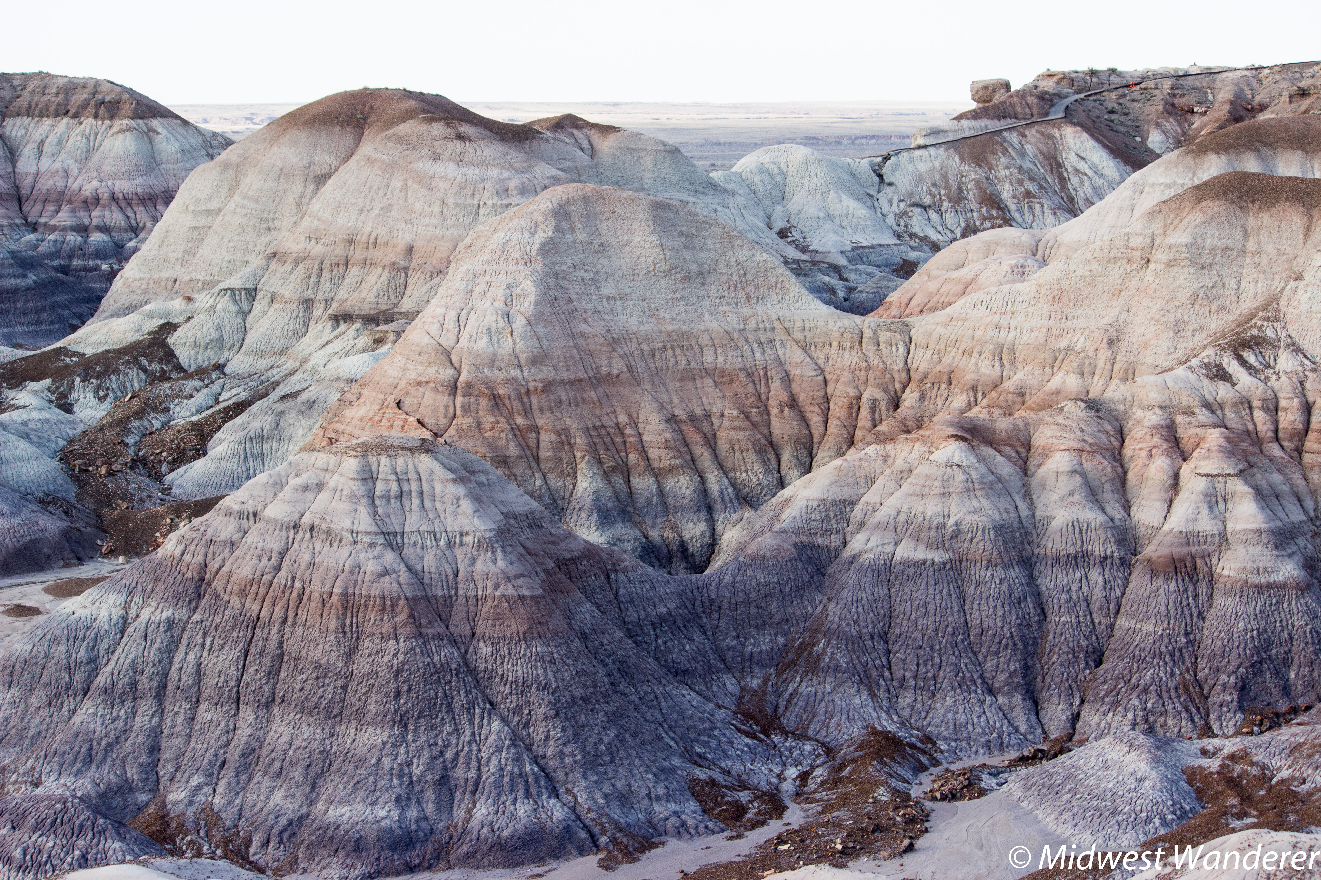
In any case the flatness shown in that Painted Desert hill is so much flatter than any salt sea or field or beach that you keep trying to palm off as the basis for it.
Here's a high resolution photo from the Painted Desert. Blow it up and scroll around and you'll see that those strata aren't as flat as you thought - there's even interbedding. --Percy Edited by Percy, : Typos.
|
|||||||||||||||||||||||||||||||||||||||
|
Capt Stormfield Member  Posts: 429 From: Vancouver Island Joined:
|
Sedimentation didn't stop, the column stopped, the "time scale" stopped. Sedimentation that is going on today has nothing to do with that. So when we look at a layer of sediment being deposited on top of existing layers, we can't tell if it's newer than the layers it's being deposited on? What with the "time scale" no longer working and all? You are batshit crazy.
|
|||||||||||||||||||||||||||||||||||||||
|
PaulK Member Posts: 17825 Joined: Member Rating: 2.2 |
quote: Please support this claim.
quote: Since your explanation is riddled with problems - solved by inventing events ad hoc - and without any significant evidence, even the evidence that should be there - it cannot be called reasonable.
|
|||||||||||||||||||||||||||||||||||||||
Faith  Suspended Member (Idle past 1466 days) Posts: 35298 From: Nevada, USA Joined: |
In any case the flatness shown in that Painted Desert hill is so much flatter than any salt sea or field or beach that you keep trying to palm off as the basis for it. Here's a high resolution photo from the Painted Desert. Blow it up and scroll around and you'll see that those strata aren't as flat as you thought - there's even interbedding. Why are you holding me responsible for a picture I didn't discuss? As you even quote, I referred only to the HILL in the picture I posted. However, the picture you posted shows lines that are so distorted by the wrinkled dried surface I would guess that they were originally quite straight and flat. Edited by Faith, : No reason given.
|
|||||||||||||||||||||||||||||||||||||||
|
Faith Suspended Member (Idle past 1466 days) Posts: 35298 From: Nevada, USA Joined: |
Sedimentation didn't stop, the column stopped, the "time scale" stopped. Sedimentation that is going on today has nothing to do with that. So when we look at a layer of sediment being deposited on top of existing layers, we can't tell if it's newer than the layers it's being deposited on? What with the "time scale" no longer working and all? You are batshit crazy. I gather you don't even know what the time scale is. It's too hard to have to keep correcting your ridiculous straw man arguments like this one. I don't think you've said one thing of any value since you decided to post here recently. Edited by Faith, : No reason given. Edited by Faith, : No reason given. Edited by Faith, : No reason given. Edited by Faith, : No reason given.
|
|||||||||||||||||||||||||||||||||||||||
|
Minnemooseus Member  Posts: 3945 From: Duluth, Minnesota, U.S. (West end of Lake Superior) Joined: Member Rating: 10.0 |
I got the general idea of the point you were making but wasn't able to follow the chain of logic. I mean that I think I understood the technical points, but not how they fit together into an argument. Here's my attempt at putting the pieces together: You first explain that the particular qualities of the garnets at the top of the Vishnu Schist required an overburden of about 6 miles in order to form. It was the video that claimed that "particular qualities of the garnets at the top of the Vishnu Schist required an overburden of about 6 miles in order to form". I really don't know the details of their reasoning, but I do know that the temperatures and pressures required for various metamorphic minerals to form can be determined through laboratory experiments.
Then you quote Faith insisting that there were only three miles above the schist. I have no idea where Faith comes up with that three mile figure. But she wants it to be the Grand Canyon Supergroup and younger currently present sedimentary rocks.
You rebut this position by saying that there cannot be high grade metamorphic rock on one side of a contact and low grade metamorphic or unmetamorphosed rock on the other side unless that contact is a nonconformity or a fault. Indeed. The rocks currently in contact with the Vishnu Schist were not there to be part of the metamorphism.
In context that would seem to be a reference to the Vishnu Schist//Tapeats contact, and your rebuttal then becomes an argument that this contact really is a nonconformity, and that deposition of the Tapeats must have taken place after the Vishnu Schist had already metamorphosed and cooled, else the Tapeats would itself have been metamorphosed though lower grade. Any rock at the same depth as the Vishnu Schist at the time of metamorphism would also have been highly metamorphosed. Back at the time of metamorphism, long before the Grand Canyon Supergroup and even longer before the Tapeats, there was supposedly (per the video) about six miles of rock above what is now left of the Vishnu Schist. That six miles, including a portion of the Vishnu, was eroded away prior to the Supergroup deposition. Were we able to see the nature of that long lost rock column, we would have seen progressively lesser grade metamorphism as we went up section. Metamorphism is not an on/off thing. You get lessening metamorphism as the pressure and/or temperature conditions decrease. Here's the analogy of how I see petrology (the study of rocks and their formation processes}: Sedimentary rocks are drinking milk. Igneous rocks are getting into drinking coffee of various strengths. Metamorphic rocks are getting into doing some heavy psychedelics. Or something like that. Moose
|
|||||||||||||||||||||||||||||||||||||||
|
Capt Stormfield Member Posts: 429 From: Vancouver Island Joined: |
The only problem is that you don't understand the implications of your own idiotic babbling. Your words are unconnected to reality. As I pointed out a few posts ago, saying that the column has stopped forming is like going outside in a snowstorm and declaring that the has snow stopped accumulating as of five minutes previously, and that the snow falling now, piling up on the existing snow, has nothing to do with that.
You are completely fucking nuts.
|
|||||||||||||||||||||||||||||||||||||||
|
RAZD Member (Idle past 1427 days)  Posts: 20714 From: the other end of the sidewalk Joined: |
I skimmed it RAZD. ... Typical. You expect us to accept your argument ...
... I don't see how a fault line falsifies anything I've said. ... It's not just one, ALL the fault lines in that area run generally NNW to SSE while the canyon runs generally ENE to WSW ... perpendicular: this indicates that your crack alignment is not related to the actual tectonic activity caused by the Kaibab Plateau being pushed east up over the land to the east. That one fault is also perpendicular to the canyon, and the erosion along it maintains the fault line -- a straight line, with NO meanders. There is NO section of the main canyon that is that straight. Near the south and west end there is a section of the canyon that parallels a fault, but not in the fault. Conclusion: the main canyon did not follow any fault line, it's alignment is not related to earth cracking. The meandering shows it formed by natural erosion.
... Without having studied your point it seems to me it could even confirm what I've been saying. Only if you ignore the parts that contradict it and cherry pick what happened in the tributary ... again typical.
RAZD Message 358: There is another place that shows a fault line capturing a river flow. See at about minute 1:55 the black lines perpendicular to the rivers, and again at about minute 2:39, where he talks about the fractures --
Again, where rivers follow fault lines they are straight, and where they flow naturally over gently sloping land they form meanders. Above the fault line the river meanders like the Grand Canyon, but once it hits the fault line it becomes straight straight straight, and NOT like the Grand Canyon.. There is NO evidence for your cracked idea, there IS evidence that contradicts it. Enjoyby our ability to understand Rebel☮American☆Zen☯Deist ... to learn ... to think ... to live ... to laugh ... to share. Join the effort to solve medical problems, AIDS/HIV, Cancer and more with Team EvC! (click)
|
|||||||||||||||||||||||||||||||||||||||
|
jar Member (Idle past 416 days)  Posts: 34026 From: Texas!! Joined: |
How did the flood deposit material under already existing material without disturbing the older layer?
Faith, you keep making assertions that the flood did things but never explain how the flood did those things. FACT: There are stone age sites all over the world and even pre-stone age sites. FACT: Those sites existed before the flood is claimed to have happened. FACT: None of those layers are more than a few tens of meters below the current surface. FACT: All of those sites were are ground/surface level. FACT: The evidence shows the site was at ground level at the time it was created by leaving evidence like fire pits and food remains and personal objects and man made objects. FACT: All of those sites were buried by known observable processes. Question: How could your flood deposit any material under an already existing layer without disturbing it?
|
|||||||||||||||||||||||||||||||||||||||
|
Faith Suspended Member (Idle past 1466 days) Posts: 35298 From: Nevada, USA Joined: |
No problem. The dating is wrong. All those sites grew up after the Flood.
NO material was deposited UNDER anything.
|
|||||||||||||||||||||||||||||||||||||||
|
Faith Suspended Member (Idle past 1466 days) Posts: 35298 From: Nevada, USA Joined: |
Faith writes: ...that the strata were all there before being disturbed in any way, which is evidence for rapid deposition,... You go on to deny that this is evidence. Hard to have a discussion with someone who denies that, makes the whole conversation futile.
Percy writes: Faith writes: That suggests there were no time gaps between layers. The unconformities are time gaps between layers. The "unconformities" are merely missing strata, time gaps only on your theory but not mine, and missing layers are more consistent with the Flood than with the Time Scale. I was saying that there should be visible erosion between layers all over the place if the Time Scale were correct, not just here and there in small amounts, and the erosion should be very apparent, cutting into strata to some depth, making obviously visibly irregular contact lines. The few examples of erosion between layers that have been posted over the years are minuscule compared to what should be there, and easily enough explained as occurring after the strata were laid down, due to water running between the layers, or even tectonic disturbance that displaces them to a small extent, especially down near the GU where such erosion is most evident, according to my scenario. PaulK asked me to produce evidence of this and it's a fair request but it would take more time and energy than I've got right now.
Percy writes: What is your evidence for the flood?
Faith writes: That the strata were all laid down rapidly without time gaps as stated above. abe: and again: I mean VISIBLE time gaps, spaces where erosion should have occurred and didn't'; I'm not talking about the supposed missing layers or unconformities. /abe. You refuse to accept this but I refuse to accept your refusal.. Same with evidence against the Time Scale (that the strata were all laid down without time gaps, meaning evidence of millions of years,
Percy writes: The geologic timescale has not ended. It cannot end unless time ends. Your faith is touching, but no, the Geological Time Scale is an artificial invention of Historical Geology based on the Geological Column with its fossils, it has no reality, it marks no real time, it came to an end when the column came to an end, at the end of the Flood which is marked by all that tectonic moving and shaking.
Faith writes: But as long as we've got a stack that climbs from Cambrian to Holocene or Eocene or close enough, whether or not there are some missing periods, that's what I mean by complete because it spans the entire Geological Time Scale. And besides, the "missing" periods are more consistent with the Flood than the Time Scale anyway.
Percy writes: A stratigraphic column with strata from the Cambrian to the present with missing periods is not complete, for two reasons. First, it has missing periods. Second, it's missing about 4 billion years of the geologic timescale before the Cambrian. I think what your trying to describe is a stratigraphic column that includes strata from each geologic period from the Cambrian to the present. That's not a complete stratigraphic column. Well, first, your four billion years are imaginary and not real, second, your missing periods are imaginary and not real, all that's missing is some sedimentary layers your theory says should be there. But my theory says there's no reason to expect sediments to be consistently deposited by the Flood. And the point I'm trying to make doesn't require the whole time scale to be there anyway, just the "oldest" and the "youngest" so that any deformation or erosion that occurred can be shown to have occurred to the entire range of strata all at once as a block or unit and not to individual layers. Partial stacks make it harder to make this point, but the whole range shows that all such disturbances occurred after all the strata were laid down. And as a matter of fact even the partial stacks show the same thing to whatever level they happen to reach, which I'll say more about farther down.
And don't forget that that doesn't mean nothing could happen to the strata in the future, such as erosion, faulting, folding, intrusions, etc., so obviously things aren't "over and done with" for these strata. I'm so far from forgetting that it's a major point I've been making all along. It's the laying down of the strata that is over and done with, all of them in place from Precambrian to Recent is over and done with, and THEN all the disturbances occurred, the erosion, the deformation etc. The whole point has been that the erosion and deformation have all occurred AFTER that, so of course they are still going on. But the laying down is over and done with.
And the evidence is that the whole stack was eroded or deformed after it was all laid down and not during the laying down.
Given the unconformities, no, the entire stratigraphic column of the Grand Staircase region was not deposited continuously with no intervening erosion. It is true that the region was tectonically quiet during deposition, but this is only true of the Grand Staircase region, not the rest of the world. I've answered this but let me answer it again. The rest of the world has only partial columns, the GS and Smith's cross section of England being the only columns that cover the entire range of time periods that I know of (the state of Tennessee has all of them but I can't find a cross section, just the map) It's just that it's harder to prove my point with a partial column. But even in those there is also no evidence of disturbance until after the entire partial stack is in place, there is no disturbance between layers, but onlyl at the top, even if the top is somewhere down in the middle of the Time Scale. You (and Geology) merely interpret the disturbance at what is now the top as having occurred in that time period whatever it happens to be, but there is no reason to do that. All that's happened is that the strata above that point were eroded away, washed away in the Flood no doubt, leaving the partial column. What is left nevertheless shows the same pattern: no disturbance until the whole stack was laid down, whole in this case being only a partial Time Scale. If it goes only up to the Permian it is still true that all the layers up to that point were laid down without any disturbance: the disturbance occurred at the Permian level but not in any Permian "time period." If up to the Triassic, no disturbance until the Triassic level, not time period, then it occurred at that level. If only up to the Devonian, then no disturbance until the Devonian level not time period. Etc. The principle I'm claiming holds in all these cases you see, it's just that I can make the case more clearly with the couple of examples where the whole range of the Time Scale is represented, which happens to be only the Smith cross section and the Grand Staircase area as far as I know.
|
|||||||||||||||||||||||||||||||||||||||
|
Faith Suspended Member (Idle past 1466 days) Posts: 35298 From: Nevada, USA Joined: |
Again, where rivers follow fault lines they are straight, and where they flow naturally over gently sloping land they form meanders. The Kaibab uplift is not "gently sloping land," it's rather steep, so it isn't going to form meanders. And your fault line doesn't seem to be in the right place for the Colorado to follow, AND without something like a fault line to follow there is no way the river is getting over that uplift. But I admit I'm not taking the time to read it all through so I could be missing your point. ABE: Just noticed your statement in an earlier post that I "expect" you to accept my argument and yet I don't spend time on your posts. Ha ha, hardly. I've long long since given up on anybody even really getting the argument let alone accepting it. So if I give short shrift to any particular post it's just that it's not what I'm thinking about at the moment or it's covering territory I'd have to spend too much time thinking about. or that sort of thing. Sorry, truly, there's just way too much stuff here for one person to deal with. Edited by Faith, : No reason given. Edited by Faith, : No reason given. Edited by Faith, : No reason given.
|
|||||||||||||||||||||||||||||||||||||||
|
|
Do Nothing Button
Copyright 2001-2023 by EvC Forum, All Rights Reserved
![]() ™ Version 4.2
™ Version 4.2
Innovative software from Qwixotic © 2024

 (1)
(1)