|

Understanding through Discussion |
|
|
Register | Sign In |
|
QuickSearch
| EvC Forum active members: 66 (9164 total) |
|
| |
| ChatGPT | |
| Total: 916,471 Year: 3,728/9,624 Month: 599/974 Week: 212/276 Day: 52/34 Hour: 0/2 |
| Thread ▼ Details |
|
Suspended Member (Idle past 1466 days)  Posts: 35298 From: Nevada, USA Joined: |
|
Thread Info
|
|
|
| Author | Topic: Motley Flood Thread (formerly Historical Science Mystification of Public) | |||||||||||||||||||||||||||||||||
|
Percy Member  Posts: 22480 From: New Hampshire Joined: Member Rating: 4.8 |
Faith writes: I don't really see how you can make an argument that there is no sign of tectonic disturbance prior to all sedimentary strata being in place by looking at only two examples. If every other pile of rocks in the world looks difference, this isn't much of a basis on which to make statements about the entire globe.
They are the only two end to end geo columns I know of,... You're misusing the term geologic column again. The geologic column is conceptual, an amalgamation of all the information gathered from stratigraphic columns around the world. It isn't something real that you can find somewhere on Earth. What I think you mean to say is that there are only two end to end stratigraphic columns that you know of. If you're referring to the Grand Staircase and Smith's diagram of England, and if by "end to end" you mean they represent the entire geologic timescale from the Cambrian forward, then you are wrong. There are unconformities (missing time) in both.
...all clearly deformed as a whole unit after all having been laid down. Since you think that layers are deformed and tilted as a whole unit, how can you also believe that that the Supergroup, which you think was once horizontal and part of the whole unit of horizontal layers above it, tilted independently?
I use them to demonstrate what I'm talking about since I know I can't prove it from them. Since you say things about the diagrams that are demonstrably untrue, you either can't see them or can't interpret them or both.
But I certainly think all the truncated columns follow the same principle,... It's not clear what you mean by "truncated columns." Are you referring to the tilted strata of the Smith diagram?
...though all I can demonstrate is that what is actually there does follow it, being deformed or eroded as a block. We'll get to "eroded as a block" when I reply to your next message.
I've said angular unconformities are the only exception, and otherwise I don't see anything in your pictures that suggests anything different than the deformation or erosion having occurred after they were in place. This is self-evidently true - why do you feel the need to say it. Of course strata cannot be deformed or eroded until they are "in place,", i.e., they exist. --Percy
|
|||||||||||||||||||||||||||||||||
|
Percy Member Posts: 22480 From: New Hampshire Joined: Member Rating: 4.8 |
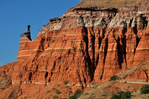
Faith writes: Just to make clear what I mean by deformation or erosion as a block or unit, with some pictures. These are only partial because that's all that's out there. I just want to point out that ALL examples exhibit this principle, with the one exception of angular unconformities:
ERODED AS A BLOCK AFTER STRATA ALL LAID DOWN One we're already seen:
The ambiguity wasn't really about what "eroded as a block" means or what "folded as block" means. It was much more about what you mean by "block". You say that that hill from the Painted Desert was eroded as a block. To make sense the block could only be those strata that are above ground and exposed to erosion. To add to the ambiguity, the strata included in your block will vary from location to location according to which strata are exposed. The Tapeats is exposed at the Grand Canyon (in some places) and so is part of your block, but it is not exposed at the Vermillion Cliffs and so is not part of your block. This is very confusing, because the Tapeats is definitely part of all stratigraphic columns where it exists extending all the way up to the surface. Adding to the confusion is that you also say strata are folded as a block. But folding mostly only happens to buried strata, so now a block is buried strata. At one point you also said these blocks were neatly demarcated, but of course there is no clear line of demarcation between what strata of a column happen to be buried and which happen to be exposed. Which strata are exposed is a function of how much erosion has occurred. I think it would be easier on all concerned, including yourself, if you adopted standard terminology. You're describing stratigraphic columns, and sometimes you're focused on the exposed portion of a stratigraphic column that is vulnerable to the forces of erosion, at other times you're focused on the buried portion of a stratigraphic column that is most vulnerable to the tectonic forces of bending, stretching and compression, and at yet other times you're focused on the complete stratigraphic column from top to bottom. You can still use the word block or unit to refer to a sequence of strata or formations or groups, but you can't say things like "strata are eroded as a block" or "erosion occurs to a block of neatly demarcated strata" (I'm paraphrasing) and be making much sense. --Percy
|
|||||||||||||||||||||||||||||||||
|
Percy Member Posts: 22480 From: New Hampshire Joined: Member Rating: 4.8 |
Faith writes: As I have pointed out the Smith diagram is misleading. And the Grand Canyon also shows very strong evidence that there were tectonic events before all the strata were laid down.
Very very few in comparison with what there should be if the Time Scale were correct. As has been explained many times, the Colorado Plateau region is unusual in how quiet tectonically it has been over an extended period of time. Yet during the period when the it was tectonically quiet other parts of the world were tectonically active, and some of these tectonically active regions are immediately adjacent to the Colorado Plateau. As the USGS webpage on the Colorado Plateau says:
quote: Did you follow that? Regions adjacent to the Colorado Plateau were very tectonically active at the same time that the Colorado Plateau was relatively tectonically quiet. This directly contradicts your claim, or in layman's terms, you're wrong yet again.
And they are all very ambiguous and can all be interpreted more reasonably my way. And yet every time you try to explain your way all kinds of problems emerge. That's why most of the time you just declaratively say something like, "The Flood explains things much better," avoiding specifics, entire posts and entire people. Other times you just endlessly repeat boneheaded claims, like that the geologic timescale has ended. A lot of the time you seem apathetic about getting anything right, as if you just need a pastime and saying provocatively wrong things gets you the responses you need to keep busy. To add to what PaulK says about the Smith diagram, while it was a revolution in understanding at the time, there is much Smith could not know and that is therefore absent from his (by today's standards) extremely primitive and undetailed diagram. This is not to take anything away from Smith, but it isn't like we haven't learned anything in the intervening 200 years. --Percy
|
|||||||||||||||||||||||||||||||||
|
Percy Member Posts: 22480 From: New Hampshire Joined: Member Rating: 4.8 |
Faith writes:
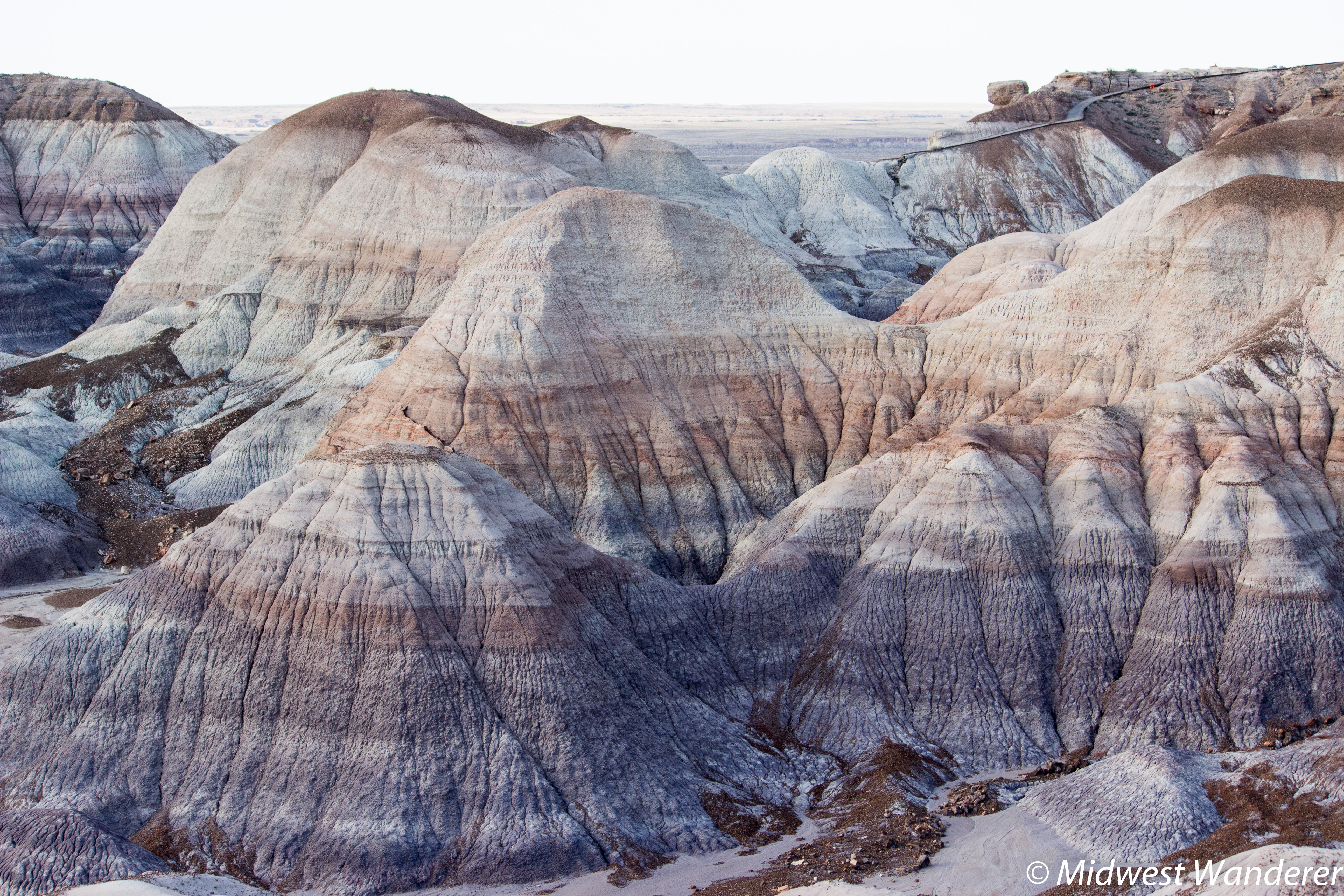
In any case the flatness shown in that Painted Desert hill is so much flatter than any salt sea or field or beach that you keep trying to palm off as the basis for it.
Here's a high resolution photo from the Painted Desert. Blow it up and scroll around and you'll see that those strata aren't as flat as you thought - there's even interbedding. Why are you holding me responsible for a picture I didn't discuss? You're making false accusations again.
As you even quote, I referred only to the HILL in the picture I posted. Yeah, so? Why does it matter what hills we look at in the Painted Desert? I needed a high res image so you could see the contacts up close, so that's what I posted.
However, the picture you posted shows lines that are so distorted by the wrinkled dried surface I would guess that they were originally quite straight and flat. Yeah, but you can't see, and when you can't see something you just make things up. Anyone who can see who blows up the image and pans around will easily find examples of tilts, crossbedding, gradations, and interbedding. Here's the image again:
I again encourage everyone to include any image under discussion in their message. It's very easy to do, and it has very little overhead. --Percy Edited by Percy, : Typo.
|
|||||||||||||||||||||||||||||||||
|
Percy Member Posts: 22480 From: New Hampshire Joined: Member Rating: 4.8 |
Faith writes: No problem. The dating is wrong. All those sites grew up after the Flood.NO material was deposited UNDER anything. We already know your Biblically based beliefs. The discussion is your opportunity to present evidence supporting what you believe. It's understandable that you to avoid doing that, since every time you attempt it you make one misstatement of fact or logic after another, but it does raise the question of why you are here. Bored, I guess? --Percy
|
|||||||||||||||||||||||||||||||||
|
Percy Member Posts: 22480 From: New Hampshire Joined: Member Rating: 4.8 |
Faith writes: Faith writes:
You go on to deny that this is evidence. Hard to have a discussion with someone who denies that, makes the whole conversation futile. ...that the strata were all there before being disturbed in any way, which is evidence for rapid deposition,... I didn't deny this was evidence, and you didn't quote my actual response. I asked about your evidence for rapid deposition, and the question remains unanswered. Undisturbed strata certainly isn't evidence of rapid deposition - lack of disturbance of strata is something that can only happen after the strata was deposited. The absence of tectonic activity after deposition is no indicator of what happened during deposition. You need evidence of rapid deposition, but you won't find it because rapid deposition is impossible. Tiny sediments falling out of suspension is an extremely slow process even in quiet water, and in the active water of your waves and tides and inundations tiny sediments would not fall out of suspension.
Percy writes: Faith writes: That suggests there were no time gaps between layers. The unconformities are time gaps between layers. The "unconformities" are merely missing strata, time gaps only on your theory but not mine, and missing layers are more consistent with the Flood than with the Time Scale. What you're saying makes no sense. Whether strata were deposited in hours or eons they still represent spans of time, so missing strata are gaps in time whether the Flood happened or not. Why do you believe missing layers are more consistent with the Flood? How do missing layers happen in a flood scenario?
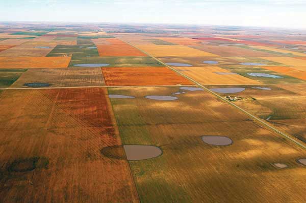
I was saying that there should be visible erosion between layers all over the place if the Time Scale were correct, not just here and there in small amounts, and the erosion should be very apparent, cutting into strata to some depth, making obviously visibly irregular contact lines. You're repeating the same error you've made in the past about erosion. Erosion levels a landscape. These landscapes were created by erosion:
Landscapes like this are very unlikely to become preserved as strata, but I've explained why many times now and I'm not going to explain again. Read back in the thread. Streams and rivers channel water will cut into a landscape, and such channels are preserved if the strata are preserved. The Kaibab was exposed to erosion carving channels up to a hundred feet deep before the Moenkopi was deposited atop it. Here's the description from the USGS Kaibab Limestone Webpage:
quote: Do you ever wonder why the Painted Desert is a bunch of mounds, wonder why the material between mounds eroded away while the mounds did not? It's because the material between the mounds was softer, and it was softer because it wasn't lake deposits of limestone and volcanic ash. It was land. Volcanic ash would have fallen on land and lake alike, but in a short time (geologically speaking) the volcanic ash on the land would have washed into the rivers and lakes. Rivers eventually silt up and change course, so it seems like we should see siltstone layers in the Chiinle, and we do.
The few examples of erosion between layers that have been posted over the years are minuscule compared to what should be there,... You keep making this silly and untrue assertion. For example, about half the layers of the Grand Canyon have unconformities between them. I've provided this list to you before, here it is again:
That's a lot of unconformities. They are, with the exception of the Coconino, marine strata formed through Walther's Law, where sea transgressions grind landscapes away. Most terrestrial erosional features created by rivers and lakes and so forth would have been obliterated.
...and easily enough explained as occurring after the strata were laid down, due to water running between the layers, or even tectonic disturbance that displaces them to a small extent, especially down near the GU where such erosion is most evident, according to my scenario. Your scenario is just something you made up that has no evidence. You are correct about one thing, that the Great Unconformity represents a great deal of erosion. The Vishnu Schist once had mountains above it to a height of six miles that eroded away before the layers of the Grand Canyon Supergroup were deposited before being tilted and themselves mostly eroded away.
PaulK asked me to produce evidence of this and it's a fair request but it would take more time and energy than I've got right now. No amount of time and energy will find what doesn't exist.
Percy writes: The geologic timescale has not ended. It cannot end unless time ends. Your faith is touching, but no, the Geological Time Scale is an artificial invention of Historical Geology based on the Geological Column with its fossils, it has no reality, it marks no real time, it came to an end when the column came to an end, at the end of the Flood which is marked by all that tectonic moving and shaking. This is just a bald declaration with no evidence or rationale. It also includes a pretty bad misunderstanding. The geologic timescale cannot be based upon the geologic column because they are one and the same. They're synonyms. The geologic timescale is a conceptualization of information from all the stratigraphic columns around the world. Your are correct that it has no material existence in that it is conceptual, the way the Periodic Table of the Elements is conceptual. It can't end by definition, as has been explained a number of times.
Faith writes: But as long as we've got a stack that climbs from Cambrian to Holocene or Eocene or close enough, whether or not there are some missing periods, that's what I mean by complete because it spans the entire Geological Time Scale. And besides, the "missing" periods are more consistent with the Flood than the Time Scale anyway. You're replying to yourself? Anyway, you haven't done anything except repeat your bald assertion again. I can only repeat the question. How can a stratigraphic sequence that has missing periods and nothing before the Cambrian be considered complete? It's a rhetorical question, since by definition it cannot.
Percy writes: A stratigraphic column with strata from the Cambrian to the present with missing periods is not complete, for two reasons. First, it has missing periods. Second, it's missing about 4 billion years of the geologic timescale before the Cambrian. I think what your trying to describe is a stratigraphic column that includes strata from each geologic period from the Cambrian to the present. That's not a complete stratigraphic column. Well, first, your four billion years are imaginary and not real,... There is evidence for approximately four billion years of geologic history, and other evidence points to an age of the Earth of about 4.56 billion years. There is no evidence for what you're pushing.
...second, your missing periods are imaginary and not real, all that's missing is some sedimentary layers your theory says should be there. There is evidence of the unconformities. There is no evidence for what you're pushing.
But my theory says there's no reason to expect sediments to be consistently deposited by the Flood. You don't have a theory - you have some cockamamie ideas based on your own personal Genesis interpretations. Your confabulations are so distant from reality that it's hard to fathom why you don't just invoke God. No one would fault you for that. But you're for some reason trying to contrive naturalistic explanations for miraculous events while not understanding almost any science and having no intuitive feel for how the real world actually works.
And the point I'm trying to make doesn't require the whole time scale to be there anyway,... Yes, exactly. And yet you claimed the entire geologic timescale was represented, which is incorrect, and so your error was pointed out.
...just the "oldest" and the "youngest" so that any deformation or erosion that occurred can be shown to have occurred to the entire range of strata all at once as a block or unit and not to individual layers. No one ever questioned that a stratigraphic column would tilt together. In fact, the only one who has questioned this is you, who thinks the Supergroup tilted independently of the layers above.
Partial stacks make it harder to make this point,... You may be looking at this in the wrong way. This stack of strata (I assume you're talking about Smith's diagram) is partial only in the sense that some time periods are not represented. The stack of strata is otherwise completely solid.
...but the whole range shows that all such disturbances occurred after all the strata were laid down. An unconformity is not a disturbance, if by disturbance you mean strata being acted upon by tectonic forces.
And as a matter of fact even the partial stacks show the same thing to whatever level they happen to reach, which I'll say more about farther down. The same what thing? You mean disturbances? If so, what disturbances are you referring to? The tilting? If so, why are you arguing about the tilting? No one questions the tilting, although keep in mind that Smith's diagram is probably like most geologic diagrams, with the vertical axis exaggerated. The tilting is likely not anywhere near as great as shown.
And don't forget that that doesn't mean nothing could happen to the strata in the future, such as erosion, faulting, folding, intrusions, etc., so obviously things aren't "over and done with" for these strata. I'm so far from forgetting that it's a major point I've been making all along. Say what? Do you get some perverse kick out of denying things you've obviously said? If the fact that things aren't "over and done with" for these strata has been a major point you've been making all along, then why did you say that things are "over and done with" for these strata? Contradict yourself much? Just for a hoot, point me to where you've made this "major point I've been making all along."
It's the laying down of the strata that is over and done with, all of them in place from Precambrian to Recent is over and done with,... Sedimentation is occurring all around the world today. Creation of new strata is not over and done with. In the context of sedimentation upon the seafloor, let's step inside your Flood scenario for a minute. During the Flood sediments deposit on the sea floor as well as the land. As the Flood waters recede from the land they carry sediments back into the seas, which already have a great deal of left over sediment. The sediments continue deposition onto the sea floors. Where the sediments are sufficiently deep lithification has already begun. The Flood ends. The land is uncovered by water and is once again exposed to the air. Rivers flowing off the continents deliver sediments into the seas. Rains cause runoff from the continents and deliver sediments into the seas. So the seas will always contain sediments, and deposition of sediments onto the sea floor will continue from the Flood right on up to the present. Where do you see some demarcation of deposition between the end of the Flood and the present that would mark the end of the formation of strata?
...and THEN all the disturbances occurred, the erosion, the deformation etc. The whole point has been that the erosion and deformation have all occurred AFTER that, so of course they are still going on. This is just made up with no evidence. If you want to offer evidence for your scenario then we can discuss it, but if you're just going to make up empty claims then all that need be said is that they're empty.
But the laying down is over and done with. You may as well deny that rivers flow to the sea.
And the evidence is that the whole stack was eroded or deformed after it was all laid down and not during the laying down.
Given the unconformities, no, the entire stratigraphic column of the Grand Staircase region was not deposited continuously with no intervening erosion. It is true that the region was tectonically quiet during deposition, but this is only true of the Grand Staircase region, not the rest of the world. I've answered this but let me answer it again. You're just going to repeat your fictional account. Making stuff up is not an answer, and repeating the stuff you made up is still not an answer.
The rest of the world has only partial columns, the GS and Smith's cross section of England being the only columns that cover the entire range of time periods that I know of (the state of Tennessee has all of them but I can't find a cross section, just the map) It's just that it's harder to prove my point with a partial column. Faith, once again, there is no stratigraphic column in the world that completely represents the entire geologic column. Not in the Grand Staircase region, not in England, not in Tennessee, not anywhere.
But even in those there is also no evidence of disturbance until after the entire partial stack is in place, there is no disturbance between layers, but onlyl at the top, even if the top is somewhere down in the middle of the Time Scale. You're repeating yourself. Here's that USGS quote again about tectonic activity surrounding the Colorado Plateau from the USGS webpage on the Colorado Plateau:
quote: Back to your message:
You (and Geology) merely interpret the disturbance at what is now the top as having occurred in that time period whatever it happens to be, but there is no reason to do that. Well, sure, there's no reason to conclude anything about when geologic events occurred, except for all the evidence. We've presented our evidence and your response is to either ignore it, be unable to comprehend it, or deny it. Meanwhile you have no evidence for any of these supposed Flood events that occurred a mere 4500 years ago.
All that's happened is that the strata above that point were eroded away, washed away in the Flood no doubt, leaving the partial column. Above what point?
What is left nevertheless shows the same pattern: no disturbance until the whole stack was laid down, whole in this case being only a partial Time Scale. See the USGS quote about the Colorado Plateau again.
If it goes only up to the Permian... There you go with the pronouns again. If what only goes up to the Permian?
...it is still true that all the layers up to that point were laid down without any disturbance:... We all agree the Colorado Plateau region was tectonically quiet for an extended period, but not in the surrounding regions, nor in many other places around the world. As far as Smith's diagram, I don't know much about the stratigraphy of England, but compared to today neither did Smith. I don't know how you can look at Smith's diagram, that you can't see anyway, and conclude there was no tectonic activity during the deposition of strata.
...the disturbance occurred at the Permian level but not in any Permian "time period." What disturbance are you referring to?
If up to the Triassic, no disturbance until the Triassic level, not time period, then it occurred at that level. If only up to the Devonian, then no disturbance until the Devonian level not time period. Etc. The principle I'm claiming holds in all these cases you see, it's just that I can make the case more clearly with the couple of examples where the whole range of the Time Scale is represented, which happens to be only the Smith cross section and the Grand Staircase area as far as I know. I can't figure out most of what you're saying here, except for the last part, so I'll just repeat that there are no complete stratigraphic columns anywhere in the world with respect to the geologic timescale. --Percy
|
|||||||||||||||||||||||||||||||||
|
Percy Member Posts: 22480 From: New Hampshire Joined: Member Rating: 4.8 |
Faith writes: You want me to support my claim that the erosion in the GC is very little and very ambiguous compared to what it should be if the Time Scale were correct, and I think that is a fair request but I'm not up to it at the moment, sorry. I do think this has been covered enough times over the years to be familiar to anyone who has been following this discussion, however. But that's not my argument, I'm just not up to the research right now, sorry. No, of course you can't spend any time on research. How could you post 12 messages a day if you had to waste your time researching and providing support for what you say? Much easier and faster to repeat the same old bald assertions and made up stories over and over again. --Percy
|
|||||||||||||||||||||||||||||||||
|
Percy Member Posts: 22480 From: New Hampshire Joined: Member Rating: 4.8 |
Faith writes: Has anybody ever reported seeing this dry and crumbly rock that you are talking about? Odd that you are so certain of your own wild guess against my far ore reasonable guess. Why is this coming as a surprise to you? Of course lithification is a gradual process. If the weight of overlying sediments wasn't enough and/or the length of time buried wasn't enough, then the strata will incompletely consolidate, leaving you with a soft and crumbly rock. The rock at Bryce Canyon can be like this. This is from Landscape & Geology in Bryce Canyon National Park:
quote: You seem to doubt that water would be forced out under pressure. Here's an interesting video where a roll of wet toilet paper is placed in a hydraulic press. I won't bore you with the whole video, this is positioned just as he crushes the wet toilet paper:
All the water is forced out because of the pressure. This is what happens to crushed sediments. As the volume decreases the water is forced out of the interstices between particles and in essence floats upward in the stratigraphic column because it is both mobile and less dense.
' How do you get fractures in dough or clay? How would strains created by uplift create a meandering fracture pattern, which is never observed anyway, You've never folded and pulled apart a ball of dough or clay? I get cracks when I do that. Folding and pulling apart? How does that match what we're talking about. The analogy is to your Flood scenario and what happens when bending and stretching results from the Kaibab Uplift. Just how much bending and stretching are you imagining was involved? However much that is, imagine your clay or dough being stretched by the same amount. In estimating the amount of bending and stretching remember that the vertical is exaggerated in the diagrams - your wet and malleable rock should be able to handle this small amount of bending and stretching without cracking with no problem. I know this is your magic rock that does anything you need it to do, but either it is malleable and can handle a little bending/stretching, or it's not malleable and it will fracture. Which is it? Why are you postulating wet and malleable rock anyway? It's made up and doesn't exist, and your Flood scenario seems to require rock that fractures rather than bends and stretches.
And I've never said anything about a meandering pattern, where are you getting that? I'm getting that from the fact that the Colorado River meanders.
It looks to me like the canyon/river cut through the uplift below the apex of the uplift but not around the bottom on the south where you would expect it to cut since it can't climb the uplift. For the umpteenth time and as many people have told you, the river originally carved it's course when the region was lower in elevation and more level in topography. The river downcut as the region uplifted.
A fracture in the rise would provide that channel which wouldn't otherwise occur on any scenario that I can see. Fractures wouldn't run across the plateau, and they wouldn't meander. --Percy
|
|||||||||||||||||||||||||||||||||
|
Percy Member Posts: 22480 From: New Hampshire Joined: Member Rating: 4.8 |
Faith writes: OK, thanks for the explanation, but it's very odd that a journalist would put words in a geologist's mouth like that. Mistakes in understanding, sure, that wouldn't be unexpected from a journalist, but this sounds like a complete fabrication for which he could even be sued. In Junior High I participated in a science fair where we transmitted sound across a room using light. We carefully explained this to the reporter. In the paper it became something like, "The light became brighter when they spoke into a microphone." The quality of science reporters varies. Becky Oskin, the reporter at Live Science, is apparently a respected science writer, a member of the National Association of Science Writers with many articles in Scientific American, so she's a good one. My guess is that "underground folding" was her translation of when Dickinson mentioned the role of subduction of the Pacific plate, which subducts at a shallow angle and causes strips of crust to pile up at great depth but well inland, like beneath the Kaibab Uplift. Maybe Edge has an opinion on that possibility. --Percy
|
|||||||||||||||||||||||||||||||||
|
Percy Member Posts: 22480 From: New Hampshire Joined: Member Rating: 4.8 |
Faith writes: There's no folding in the Supergroup. The article is not referring to the Supergroup. Your ideas about the Supergroup tilting only after the Paleozoic layers were in place while not affecting them are impossible.
Look at the cross section. The entire column of strata all rise over the Supergroup without being disturbed. No, they were not laid down over the rise, they were lifted as a block by the rise. No wonder you're impossible to keep up with. You just replied to a 332 word post with 36 words. Don't faults qualify, in your lingo, as a disturbance? The Hurricane Fault along the western perimeter of the Kaibab Uplift, and the Toroweap Fault along the eastern, occurred during the uplift. In your Flood scenario the Supergroup strata and the Paleozoic strata were originally part of the same block of strata.You say that strata tilt as a block. If this were true (and it is if there aren't additional factors) then if the Supergroup and Paleozoic strata were all present at the time of the tilt then they would have tilted together. In the vicinity of the canyon the column of strata from the Vishnu Schist up through the tilted Supergroup and up through the Paleozoic layers to the Kaibab are all uplifted as a unit. The forces of uplift came from deeper within the Earth, pushing up entire column as a whole. As PaulK notes in the context of your Flood scenario, where the Supergroup unit on the right should have exerted the greatest upward pressure (its rightmost portion) the Kaibab lining the North Rim is actually lower in elevation than further north (further left). Here's the diagram for reference:
A couple points from my post that you ignored that are worth noting:
And a correction. Though I looked it up at a couple sites, apparently they both incompletely defined the word deformation. Both Moose and Edge believe tilting is a form of deformation, and a bit more extensive poking around the Internet agrees, so I will of course adopt the correct terminology. --Percy
|
|||||||||||||||||||||||||||||||||
|
Percy Member Posts: 22480 From: New Hampshire Joined: Member Rating: 4.8
|
Edge didn't reply to this one, so I'll attempt a reply.
Faith writes: There is no way for that arch to have occurred on your scenario. This is yet another bald declaration with no evidence or reasoning. Assuming by arch Edge meant the Colorado Plateau and the Kaibab Uplift, why do you think tectonic forces incapable of creating it? Edge tends toward brevity and I don't always catch his meaning, presumably Edge will correct me if I have this wrong, but I think he is saying the same thing everyone else has been saying. Briefly summarizing in list form:
This brief little video that I've linked to a couple times shows the Supergroup strata tilting, then being eroded flat: Tilting, Faulting and Eroding of the Grand Canyon Supergroup. The video doesn't include the detail that the Shinumo Quartize is very resistant to erosion and so eroded at a slower rate than other strata of the Supergroup. Hills and cliffs of Shinumo Quarztite rose above the surrounding plains. The sea transgression that deposited the Tapeats encountered and eroded these Shinumo Quartzite hills and cliffs, explaining why boulders and other detritus of the Shinumo Quartzite can be found embedded in the Tapeats. It is widely believed that some parts of the canyons of the Colorado River are as much as 70 million years old, which is much older than the 40 million year old (at most) Claron Formation, so the Claron is unlikely to have ever overlain the Grand Canyon region. So what layers did overlie the Kaibab in the Grand Canyon region before being eroded away? My guess is that all the layers from the Moekopi to the Carmel Formation overlay the Kaibab, but not the layers now overlying the Carmel because there is a significant unconformity atop it that dates to the Middle Jurassic. The Dakota Formation overlies the Carmel Formation and is much younger, Late Cretaceous, about 90 million years younger, so it likely never existed in the Grand Canyon region. There must have been other layers above the Carmel that once overlay it. They would have formed between the Middle Jurassic and the Middle Cretaceous then eroded away and are now forever lost to geologic history. --Percy Edited by Percy, : Grammar.
|
|||||||||||||||||||||||||||||||||
|
Percy Member Posts: 22480 From: New Hampshire Joined: Member Rating: 4.8 |
Faith writes: Second, Faith does not consider the Supergroup to be part of the same block as the block from the Tapeats to the Kaibab, and it isn't clear whether her definition of "block" would place the Vishnu Schist as part of either block, but let's call them three separate blocks in Faith-land.
I think the Supergroup strata were laid down at the same time as the Paleozoic strata,... What evidence causes you to think this?
...but they were in the line of the tectonic force that uptilted them and separated them from the upper block,... I'm not sure what "in the line of the tectonic force" means, especially as something that can separate adjacent strata one from another. Could you define it? And what caused this "line of tectonic force" to affect only the Supergroup layers but not the Paleozoic layers above it? In the context of your Flood scenario, how do you explain the wild coincidence that the Supergroup layers date much older than the Paleozoic layers, and that that's also where the division between tilted and untilted layers occurs. And just so you don't forget this important unanswered question, your Flood scenario has the Supergroup layers tilted while buried - where did the missing cubic miles of rock go? Please recall before answering your previous attempts at answers and how they were shown bogus, after which you went silent.
...becoming the cause of the lifting of the upper block. It wasn't just the upper block (by which you mean the Paleozoic layers) that were lifted but the entire column, from Vishnu Schist to the Supergroup to the Paleozoic layers, as can be seen in your favorite diagram:
And it was all part of the general upheaval that cut the canyon,... What is your evidence for a general upheaval?
It's a depressing idea trying to explain how I use the terms "block" and "unit" to you, since your misunderstanding them suggests a frame of mind I have little hope of communicating with. Meaning that you can't define "block" because of the contradictory way you used it.
I really would like to avoid getting into another discussion like the one about the weird "half inch" between the Coconino and the Hermit formations that you took to be part of the Coconino. It's understandable that you would like to avoid discussions where you end up in a train wreck, unable to respond to messages like my Message 1379 and my Message 1397.
But anyway. A block and a unit are synonymous as I've been using them, yes. They refer to any part of a stack of strata that is subjected to the same forces all together rather than separately, meaning erosion or tectonic deformation at least,... In the context of strata, erosion is the wearing away of the exposed surface of strata and is not a force. Why can't you just say that exposed strata experience erosion? If you want to refer to the strata of a stratigraphic column that are exposed, why not just say "exposed strata"? How is saying "strata are eroded as a block" doing anything more than sowing confusion about what you're trying to say? Saying "strata are deformed as a block" is at least comprehensible.
...and (usually but not always) where no other strata from the same stack are present, just the one block or unit. This makes no sense. How are you defining stack? Why isn't it just another synonym for block or unit?
The pictures I posted in Message 419 of blocks of strata that were eroded and deformed as a unit were meant to be examples of what I mean. The point is to demonstrate that it s a rule that the strata were not eroded or deformed until they were all in place, which even partial blocks demonstrate. I'm looking at Message 419 now, and I don't think you know what it is you're trying to say. It is self-evidently true that strata cannot erode or deform until they are "in place," i.e., until they exist. I have no idea what a "partial block" is.
They are all pictures of blocks of strata either eroded as a block or deformed as a block. Except that they're not. Take this image for example:
You're presenting this as a block of strata that erode as a unit, but this is actually only a partial block, as we can see if we pan out a bit:
I hope this is explanatory but I guess I shouldn't hold my breath. By your definition huge continuous stretches of the Earth are a single block because they're at the surface and they're eroding. For example, the entire Colorado Plateau is a single block because it is a block of eroding strata. Exposed strata erode, but that doesn't make them part of the same block. I think what you've made clear is that it is sufficient to say that exposed strata erode. And everyone already knew that. --Percy
|
|||||||||||||||||||||||||||||||||
|
Percy Member Posts: 22480 From: New Hampshire Joined: Member Rating: 4.8 |
Faith writes: You claimed that the Smith diagram shows a stratigraphic column that completely represents the geologic timescale from the Cambrian to the present, and that if he left anything out it would still be a complete representation. That's impossible. Could you stop cluttering up the thread with inane claims?
As I explained, it's the RANGE that matters to the point I'm making, not inclusiveness. I understand, but then after making that clear you later doubled-down on your claim that the geologic timescale is completely represented from the Cambrian forward. If you don't want me to keep pointing out that that is wrong then don't keep saying it.
Though in the case of that cross section all the eras are represented in any case. You originally said from the Cambrian to the present, but the Cambrian is a period, not an era, so if you're switching to eras as I suggested then you have to change it to the Paleozoic, in which case yes, this is true. But so what? You're not making any point for which that fact would be supporting evidence. Interestingly and confusingly, the Cambrian is a period while the Precambrian is a supereon (according to Wikipedia).
Of course you are missing the point as usual. It demonstrates that the strata were tilted as one block which demonstrates that tectonic deformation occurred after they were all in place. That's the whole point of this. Why do you think you're saying anything meaningful. It is a physical requirement that strata be "in place" before they can be part of deformation. How is this not something everyone already innately understands?
But I think I should stop trying to make such simple obvious points to you. I don't know why you're explaining the bloody obvious either. As I said yesterday in Message 493:
Percy in Message 493 writes: This is self-evidently true - why do you feel the need to say it. Of course strata cannot be deformed or eroded until they are "in place,", i.e., they exist. --Percy
|
|||||||||||||||||||||||||||||||||
|
Percy Member Posts: 22480 From: New Hampshire Joined: Member Rating: 4.8 |
Faith writes: Geo column/strat column, the distinction is trivial to me. Opaque, even.
The whole idea that current sedimentation has anything to do with the geological column, or any stratigraphic column, is so foreign to me that even trying to remember to mention it may be impossible. But now that you've made an issue of it I hope I can make the effort if it really clarifies things. Understanding what geology says is a prerequisite for criticizing what it says, don't you think? Most of the time you're flying blind. --Percy
|
|||||||||||||||||||||||||||||||||
|
Percy Member Posts: 22480 From: New Hampshire Joined: Member Rating: 4.8 |
Faith writes: ..has the disadvantage of repeating things a million times that have long since been answered though you won't discover that for days.
I think your errors deserve to be corrected as often as you make them. My "errors" in this case consist of (1) my calling something a "mountain" that looks like a mountain and is identified at Google Image as a mountain; and (2) my neglecting to say that the sheet of water had to become streams in order to form a meander,... You're selling yourself short. Your mistakes, misunderstandings and miscomprehensions are legion. You just replied to an 820 word message with a 101 word message. Here are the key points you ignored:
This morning I was 50 messages behind. Now late in the afternoon I am 72 messages behind. You could help me catch up by taking the time to reply to what is posted to you. --Percy
|
|||||||||||||||||||||||||||||||||
|
|
Do Nothing Button
Copyright 2001-2023 by EvC Forum, All Rights Reserved
![]() ™ Version 4.2
™ Version 4.2
Innovative software from Qwixotic © 2024


 (1)
(1)