|

Understanding through Discussion |
|
|
Register | Sign In |
|
QuickSearch
| EvC Forum active members: 63 (9162 total) |
|
| |
| popoi | |
| Total: 916,358 Year: 3,615/9,624 Month: 486/974 Week: 99/276 Day: 27/23 Hour: 0/1 |
| Thread ▼ Details |
|
Suspended Member (Idle past 1463 days)  Posts: 35298 From: Nevada, USA Joined: |
|
Thread Info
|
|
|
| Author | Topic: Motley Flood Thread (formerly Historical Science Mystification of Public) | |||||||||||||||||||||||||||||||||
|
edge Member (Idle past 1725 days)  Posts: 4696 From: Colorado, USA Joined: |
And overall we're talking about a whole stack of deformed -- sagged -- strata. If the upper layers had been deposited after the erosion occurred to the lower layers, it woule be more convincing if they were still straight and flat as originally laid down.
I think it's pretty clear that there is more deformation of the deeper layers. The early Paleozoic rocks (left of diagram) are shown as folded whereas the most recent rocks (to the right) are almost untouched.
Since they follow the basic sag pattern of the deformation it's too much of a stretch to accept your order of events.
You ignore the erosional features and coarse sediments (gravels) that overlie the unconformities.
|
|||||||||||||||||||||||||||||||||
|
PaulK Member Posts: 17825 Joined: Member Rating: 2.2 |
Well, yeah. If you look at a map of the surface rather than the cross-section you can also see that Faith’s idea that the strata were simply tilted in a single event is less than plausible. I pointed that out the first time Faith tried using the Smith cross-section.
|
|||||||||||||||||||||||||||||||||
Faith  Suspended Member (Idle past 1463 days) Posts: 35298 From: Nevada, USA Joined: |
I'm familiar with Smith's original map, but the cross section is clear anyway, even the one with the underground strata. I really think you are completely wrong, I think it's quite clear that the strata were all laid down as usual, horizontal and straight and flat, and then all that deformation occurred afterward. I see no reason to think the underground deformation says anything at all about deposition on top of deformation, it's all deformation, period. But now it's become SO complex I have to give up on on trying to prove it, at least for now. So you win.
|
|||||||||||||||||||||||||||||||||
|
PaulK Member Posts: 17825 Joined: Member Rating: 2.2 |
quote: The more complete cross-section - which is not Smith’s and date# from 1910 is certainly clear. And it clearly shows a long history of events.
quote: And yet you can only answer my arguments by making claims that are obviously false, that obviously disagree with the actual diagram. How could it be more obvious that you are wrong ?
quote: I’ve given reasons. If you refuse to see them that’s your problem. The idea that we can’t see differences in deformation - we can’t even notice differences in direction - is obviously insane. We can see them on the diagram. I suppose you have to blind yourself avoid admitting that your lovely invention could be wrong (even though it was obviously wrong from the start) Of course if we couldn’t tell that there were multiple episodes of deformation there would be no way to tell that you were right, either. But reasoning is another area you can’t really handle.
quote: In other words it is NOT obvious that you are correct. In fact you are running away because you can’t defend your claims. Because the diagram obviously contradicts you (that is why you had to misrepresent it). But of course you won’t admit that even though any rational person can clearly see it.
|
|||||||||||||||||||||||||||||||||
|
edge Member (Idle past 1725 days) Posts: 4696 From: Colorado, USA Joined:
|
quote:Denial, the most powerful weapon in the YEC arsenal.
|
|||||||||||||||||||||||||||||||||
|
Faith Suspended Member (Idle past 1463 days) Posts: 35298 From: Nevada, USA Joined: |
Yes, I'm a terrible person and you win, OK?
ABE: If I get a second wind maybe I'll try to answer better. Edited by Faith, : No reason given.
|
|||||||||||||||||||||||||||||||||
|
PaulK Member Posts: 17825 Joined: Member Rating: 2.2 |
If you want to answer better you are going to have to overcome your irrational tendency to assume that reality is what you want it to be - even if you know better.
If the 1910 cross section obviously supported your views you’d want to use it. You don’t want to use it because it doesn’t.
|
|||||||||||||||||||||||||||||||||
|
Percy Member  Posts: 22475 From: New Hampshire Joined: Member Rating: 4.7 |
Just went through a busy period - finally a slow day.
Thanks for your ideas about how the Kaibab Uplift happened. You mention the asthenosphere at one point:
edge writes: In fact, my guess is that the deformation causing the Kaibab uplift was caused more by tension rather than compression, and related to thermal effects in the asthenosphere. Would subduction of the Pacific Plate beneath western North America be at about the depth of the asthenosphere by the time it's beneath Arizona, and if so could that be the source of the thermal effects? I'm only asking because it doesn't make sense to me that a science writer of Oskin's experience and accomplishment would make a blunder like misunderstanding Dickinson so badly that she said "underground folding" when it wasn't even close to what he meant. I still think she was trying to translate into layman's terms something Dickinson described to her, and that it may have had something to do with subduction of the Pacific Plate, which I've seen described as piling up layers of crust well inland (which is itself probably an attempt to translate science into lay terms). --Percy
|
|||||||||||||||||||||||||||||||||
|
Percy Member Posts: 22475 From: New Hampshire Joined: Member Rating: 4.7 |
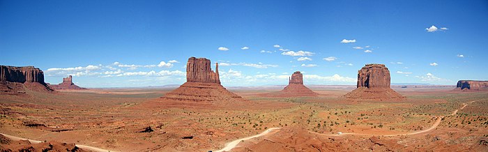
Faith writes: I'm saying one simple thing:Erosion carves canyons and cliffs and monuments and hoodoos and gullies and valleys and so on and so forth. The statement is true, all these things exist and they are caused by erosion. As Edge said, these are intermediate products. I'll take monuments as an example. This is Monument Valley:
The monuments exist because they're capped by hard conglomerate rock. The entire valley was once at the same height as the tops of the monuments - the valley was all monument from one end to the other, and the tops of the monuments were valley floor, just much higher than today. Incisions likely begun by rivers and streams created opportunities for erosion and cutback. The sides of what eventually became the monuments gradually eroded away, undercutting the hard cap which collapsed whenever support diminished sufficiently, eventually leaving us with what we see today, isolated and widely separated monuments. I'm not sure how long it will take, but eventually the monuments will be gone and only a flat valley will be left. This is because erosion flattens a landscape - eventually only plains are left. Cliffs and canyons and hoodoos and so forth are intermediate topographic features, but eventually you're left with plains. Uplift can hold it off, rising seas or subsidence can speed it up, but all land eventually erodes away. Sooner or later the land sinks beneath the waves where sedimentation resumes and more strata forms. --Percy
|
|||||||||||||||||||||||||||||||||
|
Percy Member Posts: 22475 From: New Hampshire Joined: Member Rating: 4.7 |
Faith writes: Neither your guesses nor Percy's -- and his understanding is often weirdly wrong anyway -- But you think everyone is weirdly wrong. Nothing I've said is significantly different from what everyone else is saying, though I have challenged you on some things that no one else has bothered about. --Percy
|
|||||||||||||||||||||||||||||||||
|
Percy Member Posts: 22475 From: New Hampshire Joined: Member Rating: 4.7 |
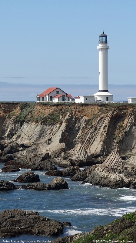
Faith writes: edge writes: Faith writes: Only by some really convoluted wacko reasoning. You can't get those neatly "tilted" rocks in a row that way. How about this terrace? The rocks are standing on end and yet they are planed off as though with a knife. Uh, tectonic pressure of course, what does that have to do with anything we are talking about?. I couldn't make out any details in Edge's image, but I was able to find a better one. This is the Port Arena Lighthouse. The sharply angled strata can best be seen on the right hand side of the image about 2/3 of the way down.
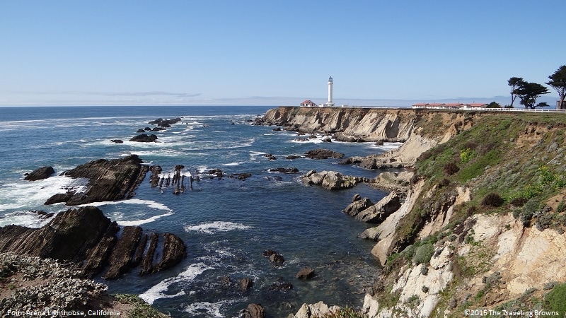
These tilted strata have been eroded flat across a great distance, as can be seen in this image from further away:
--Percy
|
|||||||||||||||||||||||||||||||||
|
Faith Suspended Member (Idle past 1463 days) Posts: 35298 From: Nevada, USA Joined: |
The monuments exist because they're capped by hard conglomerate rock. The entire valley was once at the same height as the tops of the monuments - the valley was all monument from one end to the other, and the tops of the monuments were valley floor, just much higher than today. Absolutely correct, although the valley floor was probably quite a bit higher than the tops of the monuments we see today. Where we disagree of course is that I believe the receding Flood washed away all the sediments originally surrounding the monuments leaving them standing alone. In any case the point I was making is confirmed: Strata laid down followed by erosion. Edited by Faith, : No reason given. Edited by Faith, : No reason given.
|
|||||||||||||||||||||||||||||||||
|
edge Member (Idle past 1725 days) Posts: 4696 From: Colorado, USA Joined:
|
Would subduction of the Pacific Plate beneath western North America be at about the depth of the asthenosphere by the time it's beneath Arizona, and if so could that be the source of the thermal effects?
Yes. And it's about this time that the Farallon Plate was consumed and subducted under the western edge of North America. That's when things got crazy. There are several theories. They mainly revolve about (relatively) rapid subduction of a young oceanic plate and a hot spot, whereby the subducted plate does not dive directly into the asthenosphere, but sinks a lower angle. We don't really know what happened, but at present there actually appears to be two layers of crust under the Colorado Plateau. We can see it in the seismic data. There seems to be a 'quiet layer' between two stacked, rigid plates. I'm not sure where research is going on this, but it could be a remnant of the Farallon Plate or possibly a 'delaminated' fragment of the North American crust. One theory is that the lower plate is part of an oceanic plateau that has been subducted, resulting in a non-typical convergent plate geology. Fascinating stuff and I'm sure we will be hearing more about it over the next few years.
|
|||||||||||||||||||||||||||||||||
|
edge Member (Idle past 1725 days) Posts: 4696 From: Colorado, USA Joined: |
The monuments exist because they're capped by hard conglomerate rock. The entire valley was once at the same height as the tops of the monuments - the valley was all monument from one end to the other, and the tops of the monuments were valley floor, just much higher than today.
I passed through Monument Valley early this year. If you were to look to the left of the image you presented, you would see these formations continuous to the horizon and off to the edge of the Colorado Plateau, so there is really no doubt that the monuments were once continuous. What was amazing to me is how rapidly the huge blocks of rock disintegrate when they fall and are no longer protected by the upper layer. What we are actually seeing is old petrified sand dunes turning into modern sand dunes which can be seen in various parts of the park. As to how long they will take to erode away, a very long time is my guess; mainly due to the fact that there is not a lot of rainfall or freeze and thaw action. Another example of erosion in action... Edited by edge, : No reason given.
|
|||||||||||||||||||||||||||||||||
|
edge Member (Idle past 1725 days) Posts: 4696 From: Colorado, USA Joined: |
Absolutely correct, although the valley floor was probably quite a bit higher than the tops of the monuments we see today. Where we disagree of course is that I believe the receding Flood washed away all the sediments originally surrounding the monuments leaving them standing alone.
There does not appear to be any evidence for this. Certainly, there is evidence of flash floods, but there is no evidence for Lake Missoula-type flooding or meanders around the buttes. I specifically looked for such things while there and all you can see is radial erosion away from the buttes and the usual desert washes in between.
In any case the point I was making is confirmed: Strata laid down followed by erosion.
You'll forgive me for not calling Scientific American about your discovery. But I think that to find erosion after deposition of a layer would be a lot more likely than erosion of a stratum before it is deposited.
|
|||||||||||||||||||||||||||||||||
|
|
Do Nothing Button
Copyright 2001-2023 by EvC Forum, All Rights Reserved
![]() ™ Version 4.2
™ Version 4.2
Innovative software from Qwixotic © 2024

 (1)
(1)