|

Understanding through Discussion |
|
|
Register | Sign In |
|
QuickSearch
| Thread ▼ Details |
|
Thread Info
|
|
|
| Author | Topic: Flood not the Cause of the Grand Canyon -- Not a Biased Opinion | |||||||||||||||||||||||||||
|
Admin Director  Posts: 13036 From: EvC Forum Joined: Member Rating: 2.1 |
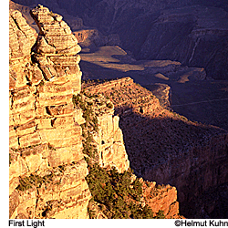
peaceharris writes: In the 2nd photo of Message 170, would you agree with me if I claimed that the light brown portion at the right half portion was originally sand, and the black portion at its right was originally a tree? Here's the photo you're referring to:
In other words, though there's no mention in any of the literature of coal at the Grand Canyon, you're going to argue that rocks that are dark are former trees that have turned to coal. No one has ever found coal in the layers of the Grand Canyon. Not all dark rocks are coal, not by a long stretch. A couple hundred years of people visiting the Grand Canyon, including a large number of geologists, have somehow failed to note that these dark rocks are coal. You are continuing the same line of argument as earlier. This is no different than the journalism student's "cliffs the color of coal" phrase that you promoted earlier as evidence of coal, only this time it is you looking at pictures and saying, in effect, "They're the color of coal, therefore they're coal." If you weren't so obviously sincere I would give you another 24-hour suspension, but please get a clue. The Grand Canyon is under no obligation to conform itself to your preconceptions. Whether or not the Grand Canyon layers were deposited by the flood, there's no coal there. Please stop arguing as if the Grand Canyon had been discovered just last week and we know nothing about it. It is probably one of the most studied geological structures in the world. If you've been following the General discussion of moderation procedures: The Sequel thread then you know I believe that explaining things like this to people doesn't help, but some people think I'm wrong. Please help prove me wrong and drop this coal argument until you have actual evidence.
|
|||||||||||||||||||||||||||
|
Randy Member (Idle past 6274 days) Posts: 420 From: Cincinnati OH USA Joined: |
Regarding the text book reference, I can't argue about data contained in that book, since I don't have that book. Too bad. Reading it might clear up some of your misconceptions about Grand Canyon geology.
Regarding the online references you have given, not a single one tells me how deep is the sandstone under these tracks. Here is a link to an abstract which discusses the Distribution of trace fossils around the Hermit trail.
quote: The dark brown/ black color cliffs in the above photo, what do you think it is due to? Probably a dark red sandstone or shale that is in shadow and above it is probably a lighter sandstone that is in the sun.
quote:Your intrepretation is wrong. There is no coal in the Grand Canyon. Do you really think that hundreds of geologists could have studied the area in person over the century or more and not reported such a obvious outcrop of coal? The South rim in the morning sun.
Now how did the animals survive the deposition of the layers below the Coconino? (Whichever you admit to being flood layers are too thick and too laterally extensive for small animals to have survived theire deposition by a supposedly global flood. How did they make tracks in the Coconino sands as they were separating from the Hermit Shale in the salty waters on Noah's flood as you have claimed? How could vertebrate and invertebrate animals make tracks that would be preserved in sand that was being rapidly deposited over a huge area in layers hundreds of feet deep by a global flood? Randy
|
|||||||||||||||||||||||||||
|
ringo Member (Idle past 439 days)  Posts: 20940 From: frozen wasteland Joined: |
Randy writes:
As an interested bystander, there is something that I would like clarified. How could vertebrate and invertebrate animals make tracks that would be preserved in sand that was being rapidly deposited over a huge area in layers hundreds of feet deep by a global flood? My understanding is that there is a layer containing tracks, and above that another layer containing tracks, and above that another layer containing tracks, etc. Geologists: Is that understanding substantially correct? PeaceHarris: If that understanding is substantially correct, how can multiple, superimposed layers of tracks be explained by animals "running uphill" to escape a flood? People who think they have all the answers usually don't understand the questions.
|
|||||||||||||||||||||||||||
|
Randy Member (Idle past 6274 days) Posts: 420 From: Cincinnati OH USA Joined: |
quote: The Coconino Sandstones are on top of the Hermit Shale. There are tracks known in both formations.
Permian Tracks There are also some animal tracks in parts of the Esplanade sandstones of the Supai group which is under the Hermit formation. The rest of the Supai group contains marine organisms. Further down in the Bright Angel shale there are many marine fossils and burrows made by various burrowing marine organisms. Randy
|
|||||||||||||||||||||||||||
|
edge Member (Idle past 1733 days)  Posts: 4696 From: Colorado, USA Joined: |
In the 2nd photo of Re: Plateau Formation (Message 170), would you agree with me if I claimed that the light brown portion at the right half portion was originally sand, and the black portion at its right was originally a tree? Not even remotely. Check out this for a description of the Vishnu schist. You will note that it says this unit, "...consists of mica schist. These were originally sediments of sandstone, limestone and shale that were metamorphosed and combined with metamorphosed lava flows to form the schist. ... The color of this layer is dark grey or black." Not coal, not a tree. PH, most geologists here have seen rock exactly like this hundreds of times. We will not mistake them for a coal bed. The lighter colored rocks are intrusive bodies of the Zoroaster Granite. Again, not a sandstone. See this site for an explanation of the two unit units.
The dark brown/ black color cliffs in the above photo, what do you think it is due to? Probably a desert varnish on red sandstone.
My interpretation of the white just above it is limestone, and the black is coal. I don't see any white. The darker cliff-forming unit in the middle distance is the Redwall Limestone. PH, have you ever even been to the GC? Have you ever taken an elementary geology course? I find it interesting and somewhat insulting that you can make completely erroneous and unsupported conclusions based only on a picture and your preconceived notion of a biblical flood; after thousands of geologists have spent careers studying these rocks and hours of time explaining them to you on this board. Your response is to simply ignore and dismiss any and all of this work as 'hilarious'. Don't you find this the least bit disrepectful and un-christian?
|
|||||||||||||||||||||||||||
|
peaceharris Member (Idle past 5623 days)  Posts: 128 Joined: |
Ringo316 writes: My understanding is that there is a layer containing tracks, and above that another layer containing tracks, and above that another layer containing tracks, etc. Geologists: Is that understanding substantially correct?
Assume that the preflood topography is marked in green. After the flood, I believe the flat strata were formed. As the waters were rising, the animals at location B would have made the tracks there. As the waters kept rising, some animal would have kept running uphill and made tracks at location A.
PeaceHarris: If that understanding is substantially correct, how can multiple, superimposed layers of tracks be explained by animals "running uphill" to escape a flood? I think you are imagining the tracks to be at location C and D. Either my explanantion is wrong, or your imagination. The tracks are not found all over the Coconino sandstone, but at localized areas, as Vincent Santucci has pointed out: If miners were allowed to drill holes, it would be possible to map out preflood topography, but all that we are seeing is what rivers and erosive forces have carved out. Both Clinton and Roosevelt apparently have prevented mining in this area. http://outside.away.com/...ide/magazine/0497/9704fewild.htmlLet me quote from Page Not Found | University of Colorado Boulder : "As in Roosevelt's time, when miners had plans to dig up both rimsof the Grand Canyon, there were howls of outrage." Try guessing what the miners wanted:a) Uranium b) Iridium c) coal d) Gold e) Plutonium I have been barred from telling you the answer.
|
|||||||||||||||||||||||||||
|
Randy Member (Idle past 6274 days) Posts: 420 From: Cincinnati OH USA Joined: |
quote:There is absolutely no evidence for this assumption. Remember those seismic surveys? They show no evidence of any "preflood" topography. (or coal for that matter and coal shows up very clearly in seismic surveys) and none of the geological work done on canyon area shows any evidence of preflood topography. It just isn't there and I think this has been explained to you before. quote:The tracks are not made on any "preflood rocks". They were made on the Hermit Shales and Coconino Sandstones which you claim are flood deposits. How could the animals have been "running up" these formations and made tracks in them as they were deposited. quote:The tracks in the Coconino Sandstones and Hermit Shale have both been found in the area of the Hermit trail. Permian Tracks They must be distributed laterally since more than 80 trackways have been found in this area, although most, but not all, that are found in Coconino sandstones in the area of the Hermit Trail are found between 39 and 46 meters above the base of the formation. quote:Miners may have wanted to explore for coal around the canyon 100 years ago. That doesn't mean it is there. The tracks we have been discussing are along the well traveled and well studied Hermit trail area. The Coconino Sandstones and Hermit Shale and Underlying Supai group have been thorougly investigated. There is no coal. End of story. Now can you answer the questions about the tracks that have been asked over and over? The tracks are not on nonexistent preflood topography. They are in the very layers that you claim are flood deposits. Randy Randy This message has been edited by Randy, 05-29-2005 10:51 PM This message has been edited by Randy, 05-29-2005 10:55 PM
|
|||||||||||||||||||||||||||
|
ringo Member (Idle past 439 days) Posts: 20940 From: frozen wasteland Joined: |
Thank you, Randy. That clarifies it for me, and hopefully for some other lurkers as well.
Peaceharris' contention that the tracks are found only in "pre-Flood" layers is wrong. People who think they have all the answers usually don't understand the questions.
|
|||||||||||||||||||||||||||
|
roxrkool Member (Idle past 1015 days)  Posts: 1497 From: Nevada Joined: |
Here's an interesting abstract on the stratigraphic distribution of tracks in the Coconino. It also discusses a possible reason why the tracks are found primarily in one area of the Coconino:
STRATIGRAPHIC DISTRIBUTION OF TETRAPOD AND INVERTEBRATE ICHNOFOSSILS IN THE PERMIAN COCONINO SANDSTONE OF GRAND CANYON NATIONAL PARK AND ADJACENT AREAS, NORTHERN ARIZONA SANTUCCI, Vincent L., National Park Service, McLean, VA 22101, Vincent_Santucci@nps.gov, HUNT, Adrian P., New Mexico Museum of Nat History, 1801 Mountain Road NW, Albuquerque, NM 87104, and LUCAS, Spencer G., New Mexico Museum of Nat History & Sci, 1801 Mountain Road NW, Albuquerque, NM 87104-1375 The Coconino Sandstone has yielded the largest assemblage of ichnofaunas of the Late Paleozoic eolian Chelichnus ichnofacies. Lull first described tetrapod tracks from the Coconino of Grand Canyon National Park (GRCA). Gilmore described the majority of specimens from GRCA based on specimens collected by three expedition of the Smithsonian Institution during 1924, 1926 and 1927. Later museum collections from the Coconino were made north of Ash Fork and Seligman, south of GRCA. In the last decade, we have investigated new in situ tetrapod specimens from GRCA. Tetrapod and invertebrate ichnofossils are non-randomly distributed in the Coconino Sandstone. The vast majority are restricted to the lower half of the unit. The Hermit basin at GRCA has yielded the largest number of ichnological specimens in stratigraphic context. At the Hermit Trail, the Coconino is about 106 m thick. The basal 6 m is barren, and tracks are rare until an interval 39.5-45.7 m above the base of the formation that yields over 90% of all tetrapod tracks and seemingly all invertebrate trace fossils. The upper half of the formation is essentially barren other than rare, poorly-preserved specimens of Chelichnus. South of GRCA, tracks in the Coconino are also restricted to an approximately 5-6 m-thick interval in the medial Coconino. McKee and later workers demonstrated a subtle sedimentologic change through the Coconino section. The lower Coconino is characterized by coarser grain size and steeper, shorter bedding planes. The upper Coconino has a finer grain size and the majority of the known wind ripples. These features apparently represent a drying trend through Coconino time. Clearly water, possibly as dew, was necessary to preserve the tracks. We hypothesize that an ideal taphonomic setting for preserving tracks that included fine grain size and the presence of water may have only been present for a short interval during medial Coconino time.
[SOURCE] edited to add source link This message has been edited by roxrkool, 05-30-2005 11:06 AM
|
|||||||||||||||||||||||||||
|
peaceharris Member (Idle past 5623 days) Posts: 128 Joined: |
According to Western Sahara Geography, there is heavy dew in the Sahara Desert.
How long do the tracks there last? The fact that coarser sand is present below, and fine sized grain is present above, is what we expect when water is sorting out the particles. Those who believe that the tracks were formed in 'Medial Coconino Time' should try explaining why the period prior to this had coarse sand, and the period following had fine sand. This message has been edited by peaceharris, 05-30-2005 01:19 AM
|
|||||||||||||||||||||||||||
|
ringo Member (Idle past 439 days) Posts: 20940 From: frozen wasteland Joined: |
Okay, I have two glib answers for this:
1. Tracks last a lot longer in "heavy dew" than they do in a flood.2. What does the Sahara Desert have to do with the Grand Canyon? People who think they have all the answers usually don't understand the questions.
|
|||||||||||||||||||||||||||
|
Randy Member (Idle past 6274 days) Posts: 420 From: Cincinnati OH USA Joined: |
quote:For this to work you need deep, still water over the 200,000 square mile area that comprises the Coconino Sandstones and the sand has to be first suspended. The water would have to be considerably deeper than the 300 foot thickness of the Coconinos at the Hermit Trail just to deposit the Coconinos, and still water would not lead to the formation of dune-like structures. How could animals make tracks that were preserved in deep water that was depositing the sand and allowing the sorting it by grain sizes. This is a question you have continually avoided. Is this the same water that deposited the siltstones, mudstones and fine grained sanstones of the 300 foot thick Hermit Formation with its animal tracks, fern fossils and dessication cracks as you claimed earlier? That means it needs to be even deeper. Did this same global flood water deposit the 300 foot thick Esplande Sandstone with its animal tracks, the 200 foot thick Wescagome Formation and the 300 foot thick Manacacha formation and the 150 thick Wahtahomigi formation of the Supai group that underlies the Hermit Shale? How deep was the flood water? Those were some pretty tough animals and insects to survive that, let alone make tracks.
quote: From the Santucci reference.
The upper Coconino has a finer grain size and the majority of the known wind ripples. These features apparently represent a drying trend through Coconino time. Whatever the explanation for the "drying trend" it certainly won't involve a global flood. The best preserved tracks including insect traces and raindrop impressions are found in between 39 and 47 meters from the base of the formation at the Hermit Trail but those not the only preserved tracks. You haven't even begun to provide a rational explanation for the animal tracks in the Coconino Sandstone, Hermit Shale and Esplande Sandstones in the framework of a global flood. Randy
|
|||||||||||||||||||||||||||
|
Randy Member (Idle past 6274 days) Posts: 420 From: Cincinnati OH USA Joined: |
Okay, I have two glib answers for this: 1. Tracks last a lot longer in "heavy dew" than they do in a flood. 2. What does the Sahara Desert have to do with the Grand Canyon? What the Sahara has to do with the Grand Canyon is that both the Sahara Desert and the Coconino Sandstones are wind formed dune fields. The dew is relevant because dew increases the cohesiveness of the sand and would help to "set" insect and animal tracks so that as wind blown sand drifted into them they would be preserved. This is explained in detail in the chapter on Coconinos in Grand Canyon Geology with references but I don't currently have an on-line reference. In any case PH has pointed to a factor that bolsters the mainstream explanation of the tracks. Randy
|
|||||||||||||||||||||||||||
|
peaceharris Member (Idle past 5623 days) Posts: 128 Joined: |
randy writes: For this to work you need deep, still water over the 200,000 square mile area that comprises the Coconino Sandstones and the sand has to be first suspended. The water would have to be considerably deeper than the 300 foot thickness of the Coconinos at the Hermit Trail just to deposit the Coconinos, and still water would not lead to the formation of dune-like structures. Some of the other members of this forum have already proved that the Coconinos was not deposited in still waters. I think you joined in late and have not read the early posts. Cross-bedding present in the Coconinos prove that the water wasn't still. In Message 100, I had explained why the tracks were not washed away by the moving waters. Moving water can carry and sort sediment. How much sediment it can carry depends on the amount of movement in the water. This message has been edited by peaceharris, 05-30-2005 11:06 PM
|
|||||||||||||||||||||||||||
|
Randy Member (Idle past 6274 days) Posts: 420 From: Cincinnati OH USA Joined: |
randy writes: For this to work you need deep, still water over the 200,000 square mile area that comprises the Coconino Sandstones and the sand has to be first suspended. The water would have to be considerably deeper than the 300 foot thickness of the Coconinos at the Hermit Trail just to deposit the Coconinos, and still water would not lead to the formation of dune-like structures. quote:So now you are saying the animals made the tracks in deep moving water. That is also absurd. The water would indeed have had to have been moving and been very deep. Yet it can't have been moving too fast if you want to sort sediments by Stokes' law which only applies at low Reynolds numbers. quote:On that thread you wrote quote:This was shown to be incorrect in message 109 but it is irrelevant. The animals would be washed away before they could make any tracks. BTW how do mud cracks in the Hermit formation and raindrop impressions in the Coconino Sandstones get "deposited" in your scenario? quote:So how much movement in how much water do you think was required to carry the all the sand in the Coconino Sandstones and the fine sand and silt that makes up the Hermit "shale"? How deep and how fast was the movement in the water that deposited the 300 foot thick Esplande Sandstone with its animal tracks, the 200 foot thick Wescagome Formation and the 300 foot thick Manacacha formation and the 150 thick Wahtahomigi formation all below the Coconinos? How were there any animals around to make tracks as the Coconinos began to form and even they were around how did they not get swept away by the deep moving water that deposited the lower 40 meters of the Coconinos around the Hermit trail so that they could make tracks in the sand that was being deposited 40-50 meters above the base of the Coconino Sandstones by moving water? Randy This message has been edited by Randy, 05-30-2005 10:26 PM
|
|||||||||||||||||||||||||||
|
|
Do Nothing Button
Copyright 2001-2023 by EvC Forum, All Rights Reserved
![]() ™ Version 4.2
™ Version 4.2
Innovative software from Qwixotic © 2024