|

Understanding through Discussion |
|
|
Register | Sign In |
|
QuickSearch
| Thread ▼ Details |
|
|
| Author | Topic: Introduction To Geology | ||||||||||||||||||||||||||||||||||||||
|
Dr Adequate Member (Idle past 311 days)  Posts: 16113 Joined: |
So far as I can see, they S-waves can't get into the core and they can't get out. But they can still exist in the core because when P-waves partially reflect off the boundary between the inner and outer core, they partially partially reflect as S-waves, as mentioned in the article. Addendum: I think this would allow us to figure out the speed of the S-waves in the inner core directly, or ... directly-ish. A P-wave passes into and through the inner core. It's partially reflected as an S-wave when it tries to leave the inner core (the resulting wave is called a PS-wave, for obvious reasons). This is partially reflected as a P-wave at the inner/outer core boundary (the resulting wave being a PSP-wave). This can pass through the outer core, and will arrive at the seismometer after the P-wave and the PPP-wave (the nature of which you can figure out yourself). We can then compare its speed with the PPP-wave. If we know how long it takes a P-wave to cross the core, we then know how long the S-wave took to make the same journey. This seems plausible, anyway. I must admit that there are lot of things I still don't know about how exactly the calculations are done.
|
||||||||||||||||||||||||||||||||||||||
|
Dr Adequate Member (Idle past 311 days) Posts: 16113 Joined:
|
Structure of the Earth
Introduction In this article we shall review some key facts on the structure of the Earth, and discuss how they are known. We shall refer back to facts already discussed in the articles on igneous rocks, seismic waves, and physical properties of rocks; readers may wish to refresh their memories on these subjects before reading further.
Structure of the Earth The Earth can be divided by composition into the crust, mantle, and core, as shown to scale in the diagram below.
The crust The crust consists mainly of igneous and metamorphic rocks with a relatively thin layer of sediment and sedimentary rocks on top. Crust comes in two varieties: continental and oceanic. Continental crust consists mainly of felsic rocks such as granite, and is about 30-50 km thick, varying from place to place; oceanic crust consists mainly of somewhat more mafic rocks such as basalt, and is about 5-10 km thick. The nature of these rocks suggests the reason why there is a crust as such. The reader may at this point find it useful to review our main article on igneous rocks. To summarize the most important points, felsic igneous rocks (i.e. those that have a high silica content) also have a lower density and a lower melting point than more mafic rocks. The minerals known as feldspar, for example, form 60% of the Earth's crust; their melting points range from 600C - 1000C degrees, depending on their exact chemical composition, and a density between 2.55 and 2.76. Compare this to the ultramafic olivine of the upper mantle, with a melting point ranging between 1200C - 1900C and a density of 3.27—3.37. This immediately suggests why the Earth should have a crust as such: that is, a region chemically distinct from the mantle. The more felsic minerals in the mantle would melt, because they have a lower melting point than the major constituents of the mantle; they would rise, being less dense by virtue both of their composition and their molten state; once they had erupted on the surface and cooled, they would "float" on the mantle as a result of their lower density. So even if the earth started off in a relatively homogeneous state (as geologists think it did) this process, known as differentiation, would ensure that the Earth ended up with a crust of rocks composed of minerals more felsic than those in the mantle.
The mantle The mantle consists of a further 2890 kilometers of denser ultramafic rocks. It is sometimes wrongly stated that the mantle consists of molten rock. We know that this cannot be true because S-waves pass through the mantle, which would not be possible if it was a fluid (see our main article on seismic waves for more details). One reason for the popular belief in a liquid mantle is that, after all, lava, a liquid, erupts from out of the mantle. However, this lava is produced by partial melting of the solid mantle. This, incidentally, is why it has a different composition from the mantle, being more felsic. Although the mantle is not liquid, it does flow: technically, it is a ductile solid, as explained in the article on physical properties of rocks.
The core The core is the innermost part of the Earth, having a radius of 3,400 km. It can be divided into the outer core, which is molten, and the inner core, with a radius of 1,220 km, which is solid. (This arrangement may seem strange at first, but recall that the inner core is at greater pressure and so will have a higher melting point.) The core is made mainly of iron. As with the existence of the crust, this can be explained on the hypothesis of differentiation: just as the light substances rose to the top, so the denser substances would sink to the bottom.
The lithosphere and athenosphere The division into crust, mantle, and core partitions the Earth according to the composition of the rocks. Sometime, however, it is more useful to group the crust and the uppermost layer of the mantle together as the lithosphere. What these have in common is that they are brittle and elastic, as opposed to the plastic and ductile rocks in the rest of the mantle. The lithosphere ranges in thickness from 40-200 km, varying from place to place; it is thicker under continental crust. The concept of the lithosphere is especially important in the context of plate tectonics. The plates in plate tectonics are not (as is sometimes stated) plates of the Earth's crust: they are plates of the lithosphere. The portion of the mantle immediately below the lithosphere is called the athenosphere. This is the weakest part of the mantle, because although it is at a lower temperature than the deeper rocks, it is also at a lower pressure.
How do we know? We shall now, as usual in these articles, sketch out how the knowledge described in the preceding sections was obtained. Let us first of all consider the facts that constrain any attempts to make a model of the physical properties of the Earth's interior.
vP and vS As we have explained in our article on seismic waves, it is possible by studying earthquakes to discover the velocities of P and S-waves at various points within the Earth. The results are summarized in the chart below.
Spherical symmetry As explained in the previous article, we call a property spherically symmetric if it varies only with the distance from the center of the Earth and not with latitude and longitude. Probably no geological property (except distance from the center itself) is exactly spherically symmetric; but many of them can be demonstrated to be very nearly so: in what follows we shall use "spherically symmetric" to mean "spherically symmetric to a good degree of approximation". As discussed in our article on seismic waves, the velocities of P and S-waves (vP and vS) are spherically symmetric properties. It would be very remarkable if this was the case, and yet the properties of the Earth on which these velocities depend was not. In the case of density, there is good evidence that it is spherically symmetric: for if it was then the force of gravity at the surface of the Earth would be (to a good degree of approximation) the same at any point on the surface; which it is. So the evidence is that density (which we shall denote by the Greek letter ρ) must be spherically symmetric. It immediately follows that the same must be true for pressure, since this can be calculated from density. Now consider the fact that for any point in the Earth the velocity of S-waves (vS) is given by the formula vS = √μ/ρ, where μ is the rigidity and ρ is the density. So given that vS and ρ are both spherically symmetric, it follows that μ must be also. Furthermore, the velocity of P-waves (vP) is gven by vP = √(κ + 4μ/3)/ρ. So given that vP, μ, and ρ are spherically symmetric, it follows that so is κ. By reasoning of this sort, exploiting the inter-relatedness of the properties that interest us, we can show that they are all spherically symmetric. So to construct a first approximate model of the Earth, we only need to associate each depth within the Earth with a value for gravity, density, incompressibility, and so forth.
Boundary conditions We know the strength of gravity at the surface of the Earth, because we can measure it directly; we also know the gravity at the center of the Earth, since in any spherically symmetric body this must be precisely 0. We know the temperature at the surface and the rate of heat flow. We know the pressure at the surface: 1 atmospheric pressure. We know the mass of the Earth, which can be easily deduced from experiments measuring Newton's constant G. Since we know this and the volume of the Earth, we also know its average density. These all serve as constraints on any Earth model. For example, if we think we know a function relating density to depth, we can easily calculate what the surface gravity of the Earth should be if this function was correct.
Interrelatedness of properties We have already used the formulas relating the properties to deduce the spherical symmetry of some properties from the spherical symmetry of other properties. But the relationships between them allow us to be much more precise than that. For example, if we know that vS = √μ/ρ, then knowing the relationship between depth and vS, and the relationship between depth and ρ, we automatically know the relationship between depth and μ. And knowing this, and knowing the relationship between depth and vP, we can exploit the formula vP = √(κ + 4μ/3)/ρ to tell us the relationship between depth and κ --- and so forth. This means that it is not necessary or even possible for us to form separate hypotheses as to the values of the various physical properties that interest us. The values that we do know (vP and vS) place constraints on the values that we would like to know.
Results To summarize: any model of the values of physical variables within the Earth must be constrained by: * The known values of vP and vS* Boundary conditions * Spherical symmetry * Self-consistency These constraints are sufficient for geologists to work out figures for pressure, density, gravity, incompressibility, and so forth. Some results are shown in the graphs below.
Here μ represents rigidity; κ incompressibility; P pressure; ρ density; and g the force of gravity.
Mineral composition Hypotheses about the mineral composition of the Earth must of course be constrained by our model of its physical properties: the minerals must have the right density, rigidity, etc to account for these properties. To date, it has been possible to drill a little over 12 km into the crust and take samples and make temperature measurements. The results are that continental crust, beneath any layers of sediment that have been deposited, is indeed composed of felsic granites, gneisses and so forth; and the oceanic crust of more mafic rocks such as basalt and gabbro. We can also study sections of ocean crust that have been thrust up onto the land --- ophiolites. These will be the subject of a subsequent article. There are a number of clues to the composition of the mantle. * Volcanic eruptions sometimes bear up to the surface fragments of peridotite; their broken jagged shapes indicate that they must have been torn from the parent rock by the force of the eruption. Unfortunately, such eruptions originate from a maximum depth of about 180 km, so they only give us a sampling of the upper mantle. * Except at subduction zones (where volcanoes recycle the material of the crust) volcanoes and rifts generally emit basaltic lava; in can be experimentally shown that this is just what would be produced by partial melting of peridotite. * The base of ophiolites is serpentinite, a rock produced from peridotite in the presence of heat and water; that is, under the conditions present in the upper mantle. * Peridotite has the right density to account for the values of ρ inferred from the seismological data. * Minerals change their phase with pressure: that is, the same elements in the same proportion adopt a more compact configuration. For example, at the pressures found at a depth of about 400 km, the mineral olivine (the main mineral constituent of peridotite) changes to beta-spinel. The seismological data indicates just the change of density at this depth that we would expect if such a change of phase took place. The other discontinuities in the density of the upper mantle are explicable in a similar manner. * We do not see any discontinuities that would definitely indicate the substitution below some depth in the mantle of some different material altogether. Although a cautious geologist would not claim absolute certainty as to the composition of the lower mantle, there is general agreement that the mantle is made of more or less the same stuff from the top of the mantle down to the top of the core. Finally, the core. The differentiation of the core into an outer liquid core and an inner solid core is based on the study of S- and P-waves. S-waves don't travel through the outer core, proving that it is liquid; P-waves travel faster through the inner core, showing an abrupt transition that corresponds well to a change of phase from solid to liquid. Given the density of the core, it must be composed mainly of iron. To be sure, it could in principle be composed of a mixture of something much heavier than iron, such as gold, mixed with something much lighter. However, iron is the only element in the Earth, in the Solar system, or in the Universe generally that is both dense enough and common enough to account for the mass. The iron probably contains an admixture of about 8% nickel, since these elements are usually found in association in these proportions. However, this iron-nickel mix would actually be too heavy to account properly for the mass of the Earth; it would follow that there must also be a proportion of lighter elements. The abundant light elements silicon and oxygen are favorite candidates for this role. Edited by Dr Adequate, : No reason given. Edited by Dr Adequate, : No reason given. Edited by Dr Adequate, : No reason given.
|
||||||||||||||||||||||||||||||||||||||
|
Dr Adequate Member (Idle past 311 days) Posts: 16113 Joined:
|
Geomagnetic reversals
Introduction In this article we shall consider the evidence for reversals of the Earth's magnetic field.
Paleomagnetism When igneous rocks are formed, as the temperature of the rock falls beneath what is known as the Curie temperature (roughly speaking, the temperature above which a material cannot be magnetized and below which it can) iron-based minerals such as magnetite and hematite are magnetized by the Earth's magnetic field, indicating the directions of the Earth's north and south magnetic poles at the time that the rocks are formed. Sedimentary rocks can also indicate these directions: when sediment is deposited gently in a low-energy environment such as the deep ocean floor, magnetized grains of magnetite and hematite will orient themselves to the Earth's magnetic field like so many tiny compass needles, indicating the directions of the north and south magnetic poles at the time the sediment was deposited. When geologists realized that this was the case, it was immediately obvious that studying the magnetism of ancient rocks would tell them about the Earth's magnetic field as it existed in the deep past: paleomagnetism
Geomagnetic reversals The study of paleomagnetism led to the discovery of magnetic field reversals. At present the Earth's magnetic field exhibits what is known as normal polarity: that is, it has the magnetic north pole near the geographic north pole, and the magnetic north pole near the geographic north pole. But studies of the paleomagnetism of ancient rocks showed evidence that in the past the Earth has sometimes had reversed polarity, with the magnetic north pole in the southern hemisphere and vice versa. Apparently, then, the Earth periodically undergoes geomagnetic reversals, in which the north and south magnetic poles switch ends.
Geomagnetic reversals; how do we know? We can see today that magnetic minerals in sedimentary and igneous rocks align themselves with the present direction of the magnetic field; and the physics of this is well-understood --- this is just what they ought to do. We can also see that some rocks laid down in the past are magnetically aligned in the opposite direction. Moreover, all the rocks dated to a particular time in the past will have the same alignment: rocks that date to 60 million years ago will all have reversed polarity no matter where you look. This really leaves us only with one plausible explanation. We can, to be sure, think of alternative implausible explanations. Perhaps the laws of physics themselves keep changing back and forth; or perhaps every now and then all the continents rapidly rotate 180 degrees in perfect synchrony. But it requires less of a stretch of the imagination to suppose that the poles themselves are moving. This is supported by the fact that the poles are detectably moving. No-one has ever witnessed a geomagnetic reversal, which is hardly surprising if, as the evidence shows, they only take place about once every 100,000 years. but the poles certainly move: the difference between true north and magnetic north has been the subject of measurement and inquiry since the sixteenth century. At the present time of writing, the north magnetic pole is moving at around 40km/year, an unusually fast rate for anything to happen in geology. While the observation of this secular variation, as it is called, does not absolutely confirm the occurrence of geomagnetic reversals in the past, it certainly gives credence to the possibility of their occurrence. Finally, in recent decades it has been possible to perform numerical simulations of the behavior of the Earth's core, starting with the work of Glatzmaier and Roberts in 1995 (which you can read here). Briefly, they put into a large and powerful computer the relevant laws of physics and the best estimates of the major forces and energies in the Earth's core. We may omit the details, but the important thing to note is that their model contained nothing explicitly relating to the motion of the poles, so that if they are found to move in the model, this must be implicit in the physics of the situation.
Their models did indeed exhibit polar reversals: one such is shown in the illustration above. The models also exhibited certain other features which must give us confidence in their broad accuracy: first, the fact that they exhibited a self-sustaining electromagnetic field at all; secondly, that they exhibit the sort of secular variation that we can observe today; third, that they exhibited one phenomenon which up until that time had never even been guessed at: that the solid inner core is rotating slightly faster than the rest of the planet: that is, it revolves slightly more than once a day. This really remarkable prediction has since been supported by seismological data (more details here). We may then regard the existence of geomagnetic reversals in the past as being on a very firm footing, since they should happen in principle and all the evidence shows that they did happen in practice. Edited by Dr Adequate, : No reason given. Edited by Dr Adequate, : No reason given. Edited by Dr Adequate, : No reason given.
|
||||||||||||||||||||||||||||||||||||||
|
RAZD Member (Idle past 1432 days)  Posts: 20714 From: the other end of the sidewalk Joined: |
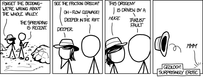
to brighten your day
xkcd: Age Milestone Privileges Enjoyby our ability to understand Rebel American Zen Deist ... to learn ... to think ... to live ... to laugh ... to share. Join the effort to solve medical problems, AIDS/HIV, Cancer and more with Team EvC! (click)
|
||||||||||||||||||||||||||||||||||||||
|
Dr Adequate Member (Idle past 311 days) Posts: 16113 Joined:
|
Plate tectonics: overview
Introduction This article consists of a short introduction to the underlying concepts of plate tectonics. Detailed discussion will be deferred to subsequent articles; but it is a good idea for the reader to have a grasp of the big picture in order to understand the relevance of the details.
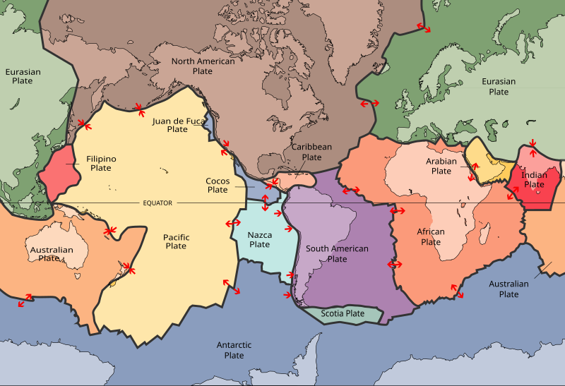
Plate tectonics: the mechanism The essential idea of plate tectonics is very simple. The lithosphere of the Earth is divided into plates, as shown in the map below: and these plates move. Plate tectonics is the study of the motion of the plates in the present and in the past.
Observing that the plates shown on the map interlock with no gaps between them, you might at first guess either that they couldn't move at all, or that they would have to do so as a body, with no movement of the plates relative to one another. However, there are two mechanisms which allow this relative motion. The first is subduction: at one edge, a plate can be forced underneath another and into the mantle. The second is sea-floor spreading: plates can move apart at a rift which is continuously filled up by intruding magma produced by partial melting of the underlying mantle, creating a continuous supply of fresh oceanic crust. This means that a plate can move along like a conveyor belt: it can move along from east to west (for example) if it is being subducted into the mantle at the west end and spreading at the east end.
Plate tectonics: history Besides explaining the mechanism of the motion of plates, the science of plate tectonics also incorporates statements about what motions have actually taken place. For example, the present distribution of continents is the result of the splitting apart of a supercontinent known as Pangaea, which was torn apart by the formation of the Atlantic Ocean. This supercontinent was itself formed by the collision of continents to form a supercontinent; these continents were fragments of a previous supercontinent known as Pannotia: and so forth. This repeated process of the rifting and joining of continents is known as the supercontinent cycle.
A deeper theory? There is a great deal of disagreement among geophysicists as to the exact nature and the relative importance of the mechanisms driving spreading and subduction: we still lack what one might call the theory of the theory of plate tectonics. What we would like is a model sufficiently good to predict such things as the average speed of a plate, or the average size of a plate. But this has so far eluded geologists. The emphasis of this textbook is however on historical geology: if we can establish that the plates do move in the present and have moved in the past, this is quite sufficient for our purposes.
Plate tectonics: how do we know? The fact that plates are moving now can be confirmed by direct measurement. To demonstrate their past motion, and the mechanisms operating now and in the past, it is necessary to study many diverse categories of evidence: too many, indeed, to compress into the space of a single article. In the following articles we shall look at the evidence piece by piece. Edited by Dr Adequate, : No reason given. Edited by Dr Adequate, : No reason given. Edited by Dr Adequate, : No reason given. Edited by Dr Adequate, : No reason given.
|
||||||||||||||||||||||||||||||||||||||
|
Dr Adequate Member (Idle past 311 days) Posts: 16113 Joined:
|
Continental drift
Introduction Continental drift is the theory that the continents have shifted their positions over time. Today, the subject of continental drift has been subsumed into plate tectonics, the science which deals with every aspect of the motion of lithospheric plates. To write about "continental drift" rather than "plate tectonics" is therefore something of an anachronism. However, there is such a lot to say about plate tectonics that it seems necessary for us to break down the subject into smaller pieces that are easier to swallow. In this article, therefore, we shall examine the notion that the continents have shifted so far as we can do so without discussing the mechanisms of plate tectonics.
The drift theory As first formulated, the drift theory was that the continents had once been joined together in a single large continent ("Pangaea") which had then split into the modern continents, which then drifted into their current positions. We now know that this was only one of a series of similar events by which continents have alternately been pushed together and pulled apart. The animation below shows the splitting apart of Pangaea.
When the drift theory was first proposed, the "drifters", as they were called, had no idea how the continents could have moved, and such proposals as they came up with were contrary to reason and evidence (as was pointed out by their opponents, the "fixists"). But, as we now know, the evidence they produced that the continents had moved was correct, and should have convinced more geologists than it did at the time.
How did they know? The initial evidence for drift As explained in the introduction to this article, what we will present here is the most superficial evidence that continents have shifted in their relative positions; specifically, that the Americas were once attached to the Old World along the eastern edge of the former and the western edge of the latter. What is presented below is therefore by no means the whole or even the majority of the evidence for continental drift; it is merely all the evidence that we can present without looking at the mechanisms of plate tectonics. When continental drift was first proposed, the arguments rested on four key pieces of evidence. * A glance at a world map shows that it looks like the Americas and the Old World once fitted together. Today, by measuring the submerged borders of the continental shelf rather than the coastline, and by using computers and the result in spherical geometry known as Euler's theorem, we can see just how good this fit is. Yet even without these techniques, a glance at a world map shows that there is something to be explained. * There are geological features that seem to be interrupted by the Atlantic: rock formations and mountains which appear to start in America and finish in Scotland. We could perhaps try to ascribe this to coincidence or to forces as yet unknown; but when we take this in conjunction with the rest of the evidence, it is more parsimonious to conclude that the Americas and the Old World were once contiguous, which entirely explains why the east coast of the Americas and the west coast of the Old World underwent the same geological processes. * Similar remarks might be made about the ranges of certain flora and fauna as indicated by their distribution in the fossil record. For some examples, see the map below, which shows the distribution of various fossil species across the southern continents, which are represented in the relative positions inferred by the "drifters". Such a distribution would be very difficult to explain if the continents had been at their present positions when these species lived. "Fixists" used to postulate "land bridges" rising and falling between continents to explain these biogeographical features, but this was very much an ad hoc explanation, for which they could provide no mechanism; and it would not explain other features that are explained by drift.
* Another piece of evidence that is inexplicable without drift is provided by past glaciations. For example, studying the striations, moraines, and other evidence for glaciation in South America, we find evidence of glaciers traveling westwards from the east coast of South America --- as though glaciers had somehow climbed out of the Atlantic to roll across South America! But this is impossible and absurd: glaciers can't climb out of the sea. However, when we observe that there is also evidence of glaciers moving across Africa towards the west coast of that continent, and that dating methods put the South American and African glaciers at the same date, we can see that the absurdity is avoided by the hypothesis that the two coastlines were once contiguous.
How do we know? More modern evidence for drift To the observations mentioned in the previous subsection we may now add further evidence that seems to belong in this article, since like the evidence in the previous section it does not require us to know how the continents move. First, there is the fact that the continents are moving right now, as can be measured by GPS (the Global Positioning System), by SLR (Satellite Laser Ranging), and by VLBI (Very Long Baseline Interferometry). Moreover, the continents are moving at the right rate. That is, if we apply geological dating methods to see how long ago the Americas parted from the Old World, if we measure the distance across the Atlantic, and if we measure the rate of drift using GPS, SLR, and VLBI, we find the numbers to be consistent. If this in itself is not conclusive evidence that the continents have been moving for millions of years, it is at least highly consistent with that proposition. We might also mention in this subsection the phenomenon of apparent polar wander, something which was only noticed in the mid-1950s, just before the plate tectonics revolution really got underway. You will recall from the article on the Earth's magnetic field that the magnetic poles observably drift around somewhat; also that information about the Earth's magnetic field is preserved in the rocks. It follows that we should be able to find out how the positions of the magnetic poles have changed in the past. However, when we try to do this, we find that the rocks on different continents give discrepant answers: all the rocks in South America (for example) will tell us that 60 million years ago (again, just as an example chosen at random) the north magnetic pole was in such-and-such a place, whereas the African rocks will all tell us that no, it wasn't, it was in another place altogether. It looks, in fact, as though there were two north poles, one controlling the deposition of rocks in Africa but having no effect on the rocks in South America, while the other affected South American paleomagnetic data while leaving Africa untouched --- and the situation only gets worse when we start taking into account the data from Australia and India and so forth, and apparently discover that there were lots of north poles 60 million years ago, one for each continent. But we can reconcile all these contradictory data with the hypothesis of continental drift. All we need to do is suppose that when the paleomagnetic data were laid down, they were all perfectly consistent and showed the north pole as being in exactly the same place, but that since then the continents have shifted their positions relative to one another and to the poles, leaving the paleomagnetism in the rocks pointing in different directions for each continent. This is more than an ad hoc hypothesis to account for the paleomagnetic data. If we want to reconcile the data, we have to do more than wave our hands in the air and say: "what if the continents were in different positions once?" Instead, we have to propose specific positions that they were in: and we find that this exercise leads us to the same conclusions as we arrive at when studying the other data, such as biogeography, glacial striations, geological formations, and other evidence which we shall mention in subsequent articles.
The drift controversy: a historical footnote When the drift hypothesis was first proposed, it met with stiff opposition; opposition which, with the 20/20 view of hindsight, seems unjustified. Drift could, after all, explain a number of anomalous features in geology; whereas the "fixists" had only an ad hoc explanation for the facts of biogeography and no explanation for anything else explained by drift. The drifters were handicapped by having no good explanation for how drift could occur; indeed, they were handicapped by having a bad explanation: that continents plowed through oceanic crust like icebergs through water; an explanation which was demonstrably false. Also, they did not then have the technology to prove that the continents are still in motion: they had no GPS, no SLR, and no VLBI to appeal to. If they could have shown that the continents were indeed moving, then the problem of explaining how could have been left to future geologists. Nonetheless, in retrospect the drifters should have been granted more acceptance than they were. It is, after all, usually the case that scientists accept the existence of a phenomenon before finding a mechanism for it; science could hardly have progressed otherwise. However, some popular authors have exaggerated the opposition to continental drift, portraying the leader of the "drifters", Wegener, as a modern-day Galileo persecuted by a scientific rather than a religious establishment. This is far from the truth. Wegener was well-respected as a scientist: his textbook on meteorology became a standard work; his book on continental drift was translated into several languages; he had a professorship specially created for him at an Austrian University; he won the support of some other geologists, mainly in Britain and continental Europe; and he was able to get funding for his research. In fact, he died of overexertion on an expedition to Greenland costing $1.5 million in today's money, and if no-one had taken him seriously as a scientist he might have lived beyond 50. Whatever the rights and wrongs of the drift controversy, it is a fact that drift was not widely accepted until the revolution in geology attendant on the birth of plate tectonics. We shall discuss this newer and more conclusive evidence in the next few sections of this textbook. Edited by Dr Adequate, : No reason given. Edited by Dr Adequate, : No reason given. Edited by Dr Adequate, : No reason given. Edited by Dr Adequate, : No reason given. Edited by Dr Adequate, : No reason given.
|
||||||||||||||||||||||||||||||||||||||
|
Dr Adequate Member (Idle past 311 days) Posts: 16113 Joined:
|
Sea-floor spreading
Introduction In this article we shall explain what sea-floor spreading is, and the role it plays in plate tectonics; we shall conclude, as usual, with an explanation of how we know that sea-floor spreading is taking and has taken place.
The nature and role of sea-floor spreading The sea floor is divided by a system of mountain ranges (mid-ocean ridges) each with a deep valley running down the center (mid-ocean rifts); an example is shown in the chart below, which displays the topography of a northerly portion of the mid-Atlantic ridge.
According to the theory of plate tectonics, plates move apart at the rifts. As the lithospheric plates move apart, this makes a gap into which magma intrudes; it also reduces the pressure on the athenosphere below, causing partial melting of the mantle material. The intrusion of this material ensures that the rift is always being filled up by a fresh supply of oceanic crust. This whole process is known as sea-floor spreading. One common misconception is that the intrusion of the magma at the rifts causes the motion of the lithospheric plates. In fact, geologists are well-agreed that this does little or nothing to cause the motion, rather, as explained in the previous paragraph, it is actually the parting of the plate at the ridges which causes the intrusion of the magma. Nonetheless, sea-floor spreading plays a crucial role in plate tectonics: if the plates were unable to move apart at rifts, they would be unable to move at all. In the remainder of this article we shall survey the evidence for sea-floor spreading.
Sea floor spreading: how do we know? The proposition that the sea floor spreads out from the mid-ocean rifts, and has been doing so for millions of years, implies a diverse assortment of testable predictions, all of which turn out to be true.
Paleomagnetism As we discussed in a previous article, the Earth's magnetic poles keep swapping their positions. This leads us to a prediction. If the sea floor has been spreading out due to the formation of igneous rocks at the deep-sea rifts, then when we look at the pattern of positive and magnetic anomalies in the igneous rocks that form the oceanic crust, what we ought to see is a pattern of stripes of alternating positive and negative anomalies, parallel to the mid-ocean rift. And this is just what we do see; as shown, for example, in the diagram below. The measurements were taken in a strip of ocean around the mid-Atlantic ridge, south and west of Iceland. Black represents normal magnetic anomalies and white represents reversed magnetic anomalies; the mid-Atlantic ridge, running south-southwest, is the axis of symmetry.
Heat flow Heat only conducts very slowly through large bodies of rock. Consequently, we expect the flow of heat from the sea floor to be greatest at the ridges and to gradually decline as we look at the sea floor further away from them.
The diagram above, produced from over 24,000 measurements of heat flow, shows that this is in fact the case. It is this cooling process that explains why the rifts are flanked by ridges on either side, which gradually slope down as we get further from the rift: the newly produced rock is hotter, and therefore has greater volume than the older rock; the older rock, having moved further from the rift, has had more time to cool down and so to contract. This, by the way, explains why islands capped with coral so often subside into the sea, as we mentioned in our article on reefs: as the basalt of the islands is carried further geographically from the rift, and further in time from the heat in which it was formed, it and the rest of the oceanic crust below it will cool, contract, and therefore subside.
Dating For the same reason, if the sea floor is spreading out from the rifts, another obvious prediction of the theory is that if geologists apply their dating methods to the basalt sea-floor on either side of a rift, the rocks will be found to be older the further out they are from the ridge system; as is the case, as shown in the diagram below:
Accumulation of sediment Similarly, sediment will have been accumulating on the older parts of the sea-floor for longer than on the newer parts around the mid-ocean rifts, resulting in a deeper sedimentary layer further out from the rifts; as is also the case.
Fossils Likewise, if the theory of sea-floor spreading is correct, then at any point on the sea floor the fossils found by drilling at the bottom of the sea-floor sediment will be those deposited when that bit of the sea-floor was freshly produced at the rift. This means that if we look at these deepest-buried fossils, we will see older and older fossils as we look further and further from the ridge; as a result we will see a greater proportion of extinct species. And this is in fact what we see.
The layer-cake effect Different sediments tend to accumulate on different parts of the ocean floor. If the ocean floor stayed still, then, other things being equal, we would expect a sample of the sediment from any particular place on the sea floor to be pretty much the same all the way down. But according to the theory of sea-floor spreading, the sea-floor has been continuously moving outward from the ridge systems like a conveyor belt, which implies that different sediments will have settled over the same portion of sea-floor as it moved. So, for example, marine carbonates settle on the mid-Atlantic rift and rise, because in those shallow waters are above the carbonate compensation depth. Further out, where the waters are deeper, only pelagic mud will settle. So if the sea-floor really has been acting like a conveyor-belt, then when we take a sediment sample from areas of the Atlantic where pelagic mud settles, we should find this mud overlies a layer of limestone that settled when that portion of sea-floor was nearer the ridge; which is what we find. And in general we can state the rule that for any particular spot on the ocean bed, the layers of sediment from bottom to top should be consistent with the journey of the sea-floor from the ridge outwards; which is what we find. So, for example, the conveyor belt moving northwest from the east Pacific Rise west of South America towards Japan crosses the equator and the region where siliceous ooze is deposited. So near Japan we should and do find (from bottom to top) carbonate sediments deposited in the shallow waters at the Pacific Rise; pelagic mud from deeper and non-equatorial waters; calcareous/siliceous ooze as the conveyor belt crosses the equator; and more pelagic mud that accumulates north of the equator.
Lateral faults The mid-ocean ridges do not run in a continuous line on the ocean floor: rather, they are discontinuous, being displaced laterally along their length at faults, as can be seen in the map at the top of this article. This leads to an interesting prediction. The top picture in the diagram below shows an ordinary lateral fault such as the San Andreas fault, with a road cutting across it. From either side of the fault, one sees the road as being displaced to the left, making it a left lateral fault. Clearly, if you were standing on one side of the fault during an earthquake, you would see the land on the other side of the fault moving to the left relative to you.
Now consider the lower picture in the diagram. Standing on either side of the fault and looking at the ocean floor on the other side of the fault, you would see the mid-ocean ridge as being displaced to the left on the far side of the fault. But if geologists are right about the sea floor spreading out from the mid-ocean ridges, then if you stood on one side of the fault and looked across it during an earthquake, you would see the sea floor on the opposite side moving to the right relative to you. And this is what we do in fact observe.
Rate of continental drift The measured rate of sea-floor spreading at the ridges agrees with the measured rate of continental drift, and the inferred rate at which geologists calculate it must have taken place in the past.
Conclusion All these disparate lines of evidence add up to a convincing demonstration that the sea floor is currently spreading from the mid-ocean rifts, and has done so in the past. Edited by Dr Adequate, : No reason given. Edited by Dr Adequate, : No reason given.
|
||||||||||||||||||||||||||||||||||||||
|
Dr Adequate Member (Idle past 311 days) Posts: 16113 Joined:
|
I have put an overview of plate tectonics in front of the already-posted articles on continental drift and sea-floor spreading. This should make it easier to follow what it is the articles following it are there for.
|
||||||||||||||||||||||||||||||||||||||
|
anglagard Member (Idle past 863 days)  Posts: 2339 From: Socorro, New Mexico USA Joined: |
I am just curious Dr. A. As a person who graduated from New Mexico Tech way back in 1982 in geological engineering how is it that you have such deep knowledge of the subject? Does it come from formal education or are you self-educated like jar?
Everything you have stated in this thread is dead on according to what I remember. (Also rather enjoy the....what Moose would call snark).Read not to contradict and confute, not to believe and take for granted, not to find talk and discourse, but to weigh and consider. - Francis Bacon
|
||||||||||||||||||||||||||||||||||||||
|
Dr Adequate Member (Idle past 311 days) Posts: 16113 Joined:
|
Subduction
Introduction Subduction is the process whereby the edge of one plate slides under another and into the mantle. In this article we shall examine the evidence for subduction and the role it plays in plate tectonics.
Subduction: an overview As we have discussed in our article on sea-floor spreading, rock is generated at mid-ocean rifts; when it is produced in this way it is hot and therefore buoyant. As rock spreads out from he rifts, it cools down, and also thickens as material from the upper mantle accumulates on the underside of the cooling crust, both of which processes makes it denser. Eventually, as a result of this, it becomes gravitationally unstable and liable to plunge into the athenosphere. It cannot simply sink straight down like a foundering ship, for two reasons. First, it is still attached to the more buoyant portion of the plate. Second, in order to do so it would have to displace the material of the athenosphere in a way that is physically implausible. To grasp this point, consider a sheet of paper floating on the surface of a bowl of water. The paper is more dense than the water and should sink, but it cannot sink straight down in its horizontal attitude without pushing up the water surrounding it. However, if one edge of the paper is forced beneath the water, then the sheet of paper can descend down and sideways, sliding edge-on through the water. And this is what happens to oceanic crust when it subducts; forced beneath another more buoyant plate, is slides edge-first into the athenosphere. The portion of the plate being thrust down in this way is called the slab. A typical angle of descent is 45 degrees, but the slab can descend at any angle from near-horizontal to near-vertical.
The diagram above shows a cross-section of the process. (The reader should note that the diagram is somewhat schematic in nature and not entirely to scale.) Key: (1) a volcano (2) the sea (3) oceanic crust (4) a trench containing an accretionary wedge (5) continental crust (6) lithospheric mantle (7) the athenosphere (8) partial melting of the slab. In the diagram, oceanic crust (on the left) is being subducted under continental crust (on the right). The triangular gap formed where it bends to go under the continental crust is known as a trench. For reasons that we shall discuss below, the subducted slab undergoes partial melting at a depth of about 120 km, producing volcanoes above the melting. In our diagram we have chosen to show oceanic crust being subducted beneath continental crust. An oceanic plate can equally well subduct beneath another oceanic plate with much the same results, only forming a chain of volcanic islands and seamounts instead of a volcanic mountain range. In the diagram we have shown the trench filled up with sediment, forming what is know as an accretionary wedge or accretionary prism. However, not all trenches have such a feature: this depends on the rate at which sediment is transported into the trench and the rate at which it is subducted along with the plate. As a general rule, an accretionary wedge will be present when the trench is close to a continent, as this ensures a greater supply of sediment than can be found further out to sea.
Evidence for subduction In this section, we shall look at the evidence for subduction.
The existence of sea-floor spreading As we have seen in our article on sea-floor spreading, new crust is generated at the mid-ocean rifts and spreads outward from them, and has been doing so for millions of years. This raises the obvious question of where it goes to. The earth's surface cannot simply inflate like a balloon; and looking at the sea floor, we can see that neither does it ruck up like a carpet too big for the room it's laid in. The only possible explanation is that crust is being destroyed, and the only reasonable way that this can happen is for the crust to be recycled back into the mantle. So the evidence for sea floor spreading is on the face of it evidence that subduction must happen: or at the very least that something must be destroying oceanic crust.
Age of the sea floor One consequence of the production of the sea floor at rifts and destruction of sea-floor at subduction zones is that the sea floor should consist of rocks younger than the Earth itself. And this is what we find: the oldest rocks on the ocean floor date to about 200 million years old, as compared to 4 billion for the oldest continental rocks. For the same reason, the layers of sediment on the ocean floor are thinner than those on the continents, and the fossils are more recent. As with the previous point, this is good evidence that the oceanic crust is being destroyed by some mechanism. We can now turn to the evidence that the mechanism is indeed subduction.
Earthquakes If a slab of cold, brittle, elastic rock is really being subducted into the athenosphere, then we should expect it to undergo earthquakes as large bodies of rock in this state always do when placed under stress. Because it is possible to measure the depth of an earthquake (see here for details) as well as its latitude and longitude, observations of earthquakes allow us to form a good picture of what happens when a slab descends into the athenosphere. The diagram below, for example, shows the locations of earthquakes of magnitude 4.5 or greater occurring between 1973 and 2004 where the Indo-Australian plate is subducted under the Lesser Sunda Islands. The profile of the slab is clearly traced out by the incidence of earthquakes. (The US Geological Survey's Earthquake Hazards Program has many such maps of subduction zones.)
We should note that without subduction there shouldn't be earthquakes below the lithosphere at all. In rocks below the lithosphere the temperature and pressure are such that rocks under stress at that depth should bend, stretch and flow, producing no earthquakes. The only plausible explanation for quakes at these depths is that colder more brittle rock from the surface has been thrust down into the athenosphere. (In considering this, the reader should bear in mind that the slab is several kilometers thick and that heat flows very slowly through rocks, so there is no difficulty in a subducted slab remaining brittle and relatively cold for millions of years after it enters the athenosphere.)
Volcanoes and subduction melting Water lowers the melting point of rock in a manner similar to how salt lowers the melting point of ice; the result is that when the wet rocks of the crust reach the right zone of temperature and pressure, about 120 km below the surface, the rocks of the crust undergo partial melting. (The fact that this should occur at 120 km depths can be verified in the laboratory by simulating the appropriate temperature and pressure.) Naturally the hot and relatively less dense molten rock rises through the athenosphere and escapes to the surface as lava, forming volcanic mountain chains if the slab is subducting under continental crust, or chains of volcanic islands and seamounts if the slab is being subducted under a continental crust. It is estimated that up to 20% of subducted rocks are returned to the crust by this mechanism. Because we can use seismic readings to measure the angle of the slab, and because we know that partial melting occurs at a depth of about 120 km, we can use simple geometry to calculate where, relative to the subduction zone, the volcanic arcs should occur. The fact that they always do occur in the right place supports the idea that geologists really do know what's going on in the athenosphere.
Trenches The existence of trenches were once a mystery to geologists. But the mechanism of subduction makes everything clear: there must be a trench, roughly triangular in cross-section, between a descending slab and the plate under which it is subducted. If this is the true explanation, then we should expect to find these trenches and accretionary wedges in geographical association with the earthquakes and volcanism which we also attribute to subduction; and this is in fact what we find. Edited by Dr Adequate, : No reason given. Edited by Dr Adequate, : No reason given.
|
||||||||||||||||||||||||||||||||||||||
|
Dr Adequate Member (Idle past 311 days) Posts: 16113 Joined: |
I am just curious Dr. A. As a person who graduated from New Mexico Tech way back in 1982 in geological engineering how is it that you have such deep knowledge of the subject? I'm blushing. Edited by Dr Adequate, : No reason given.
|
||||||||||||||||||||||||||||||||||||||
|
Dr Adequate Member (Idle past 311 days) Posts: 16113 Joined:
|
Hotspots
Introduction In this article we shall discuss the evidence for hotspots and what, if anything, they can tell us about plate tectonics.
Aseismic ridges In several places the sea floor is scarred by what are known as aseismic ridges. These consist of a linear trail of volcanic islands or seamounts. When dating methods are applied to these, it is invariably found that the volcanic rocks along the ridge are arranged in order of age, with the youngest rocks at one end and successively older rocks as we look further along the ridge. Any current volcanic activity will be found at the young end of the ridge. The canonical example of an aseismic ridge is the Hawaiian islands.
Dating methods reveal that the islands are arranged in order of age from east to west, with Hawaii being the youngest, Maui being older than Hawaii, Oahu being older than Maui, and so on along the island chain. Hawaii itself (the "Big Island") is volcanically active; Maui, next in line, has not erupted since the eighteenth century; Molokai and all the islands further west are considered to be extinct. To the east of Hawaii is an area of seafloor volcanism known as Lohi (not marked on the map); if this activity continues for ten or twenty thousand more years it will build a new Hawaiian island younger still than Hawaii.
Hotspots With the discovery of plate tectonics, geologists were able to explain aseismic ridges. They said: suppose there are places in the mantle where, for some reason, hot rock tends to rise in mantle plumes. The point on the surface above such a plume would be a hotspot, a place of high volcanic activity. Now consider the fact that the lithospheric plates are moving. This would perfectly explain such things as the Hawaiian island chain: currently, the mantle plume is under Hawaii, but before that it was under Maui, and before that it was under Molokai, and so on. If you picture a conveyor belt slowly moving over a blowtorch, then you have the theory of hotspots in a nutshell: the mantle plume is the blowtorch, the plates in motion are the conveyor belt, and the trail of burned and molten material is the volcanoes. The reader may be wondering why mantle plumes exist, and why they apparently persist in the same place for millions of years. The geological community replies that this is "not fully understood", which is how geologists say: "We have no idea. Can you get us some research funding and come back in ten years?"
Hotspots: how do we know, and what do they tell us? Hotspots are sometimes adduced as evidence for the motion of plates. But we should be extremely cautious in saying so. Hotspots, we are told, stand still, so the trail of islands and seamounts they leave behind them indicate the motion of plates. But how do we know that hotspots stay still? Geologists do not as yet have such a good grasp on the dynamics of the mantle that they can declare on theoretical grounds that hotspots should stay still. Rather, the fact that they stay in one spot is itself an inference from the fact that the plates are moving: if we calculate the motion of the plates using dating, paleomagnetism and so forth, we see that the trails made by the aseismic ridges are explicable on the hypothesis that the hotspots are stationary. Direct measurement also supports this hypothesis: for example, the Hawaiian islands are measurably moving westwards; if the hotspot stayed still, this would account for the observations. So the idea that hotspots are more or less stationary is well-supported by the evidence, but all the evidence for this comes down the evidence that the plates are moving. If we were then to take as a premise that hotspots are stationary, and use this as evidence that the plates are in motion, we would be guilty of the grossest form of circular reasoning. There is a modest way in which the existence of hotspots does suggest that the plates are moving. For it is a fact that all the aseismic ridges of a given plate will trend in the same direction: if one aseismic ridge runs east-west and is oldest at the east end, then that will be true of every aseismic ridge on that plate: for example, the Hawaiian islands display the same trend as the Louisville Seamounts. Now it is more parsimonious to believe that all the hotspots are staying still and that the common trend of the aseismic ridges is produced by the motion of the plate, than it is to believe that the plate is standing still but that all the hotspots just happen to be moving in the same direction. Edited by Dr Adequate, : No reason given. Edited by Dr Adequate, : No reason given.
|
||||||||||||||||||||||||||||||||||||||
|
Dr Adequate Member (Idle past 311 days) Posts: 16113 Joined:
|
Terranes
Introduction In this article we shall discuss what a terrane is and how the existence of terranes can be explained by the mechanisms of plate tectonics already discussed.
What is a terrane? A terrane is a part of a landmass, bounded by tectonic faults, which is different in many ways from the main landmass to which it is attached. Geologists ascribe this to the terranes having originally been separate from the main landmass, and being borne up against the edge of the landmass by the motion of plates. As we have discussed, oceanic crust is usually simply subducted beneath continental crust. But if some material (for example an island) can not or does not subduct (because of its greater thickness or lower density than oceanic crust, or for some other reason) then instead it will dock against the edge of the landmass. One example of terrane formation is shown in highly schematic form below.
In picture 1 we see a microcontinent traveling from left to right along with the oceanic crust in which it's embedded; at the right of the picture we see the oceanic crust subducting beneath a continent. In picture 2 the microcontinent has collided with the continent, incidentally squeezing up the sediment in the accretionary wedge between them. In this particular example, this has produced not one but two terranes: the former island and the former sedimentary wedge. The former microcontinent is now the left end of the continent, and the oceanic crust is now subducting beneath that. The result is that after the docking has taken place we have three regions sitting side by side which are bounded by faults and which have no common geological history. Of course, after the point at which they dock, they can and will share a history; a lava flow, or an ashfall, or deposition of sediment, can then cover them all in common; or a river could cut its way through all three. But until they join, there is no reason why they should have anything in common. The map below (from the United States Geological Service) shows some of the terranes on the western coast of North America, where they have been particularly well studied. The terannes are color-coded by type.
Note that not all terranes are formed in exactly the manner of our example above; however, they all do appear to have been formed in the same general manner, i.e. by material being transported by the motion of plates to the western edge of the continent and sticking there.
Terranes: how do we know? We have said that a terrane will have a different geological history from the surrounding areas on the same landmass. For example: * The terrane will have different types of sedimentary rocks from the main landmass. * The sedimentary rocks will typically contain different fossils from the main landmass. * Also, the fossils and sediments often indicate a different environment from the main landmass; they may, for example, be indicative of a marine environment. * Not only this, but the fossils in a terrane may indicate a different climatic zone from the landmass to which it is attached: for example, they may be tropical fossils, such as coral, found in an environment which is far from being tropical. * The terrane will often look like it was once something in particular other than just another part of the continent; it will look like it has formerly been oceanic sediment, or a volcanic island arc, or a piece of oceanic crust. * The basement rock of the terrane is often different from that of the main landmass in obvious ways: we may, for example, see basalt in the terrane adjoining granite in the main landmass. * The basement rock will frequently yield different dates on different sides of the fault when absolute dating methods are applied. * Extensive geological features such as lava flows or layers of volcanic ash may terminate abruptly at the edges of the terrane. * The terrane will have a different paleomagnetic history from the landmass to which it is adjoined. What is more, these features will go together. That is, the fossil evidence, the paleomagnetic evidence, the evidence from dating, the different sediments, the different basement rocks, and so forth, will all identify exactly the same fault-bounded area as being a terrane. If you really wanted to, then perhaps you could try to explain each of these features away one by one (or at least try to imagine that there's some explanation which you can't think of yet) but how would you go about explaining why these features of a terrane are coterminous? Terranes look, in short, as though they came from somewhere else and were somehow tacked on to the main body of the landmasses to which they are now attached. And so it is reasonable to conclude that this is in fact what happened. Furthermore, we can understand why they should have been transported and attached in this way. What would otherwise be a puzzle becomes an expectation in the light of plate tectonics. What would be more natural than to find seamounts, volcanic islands, and marine sediments scraped off the edge of a subducting plate? This view of terranes is strengthened by the observation that the evidence shows that terranes became joined to landmasses at times and in places where on other grounds we think that subduction was taking place. For example, since the Atlantic ocean is being formed by rifting, we should not expect to find any terranes on the Atlantic side of America which date to younger than the Atlantic; and we don't. Meanwhile we find plenty of more recent terranes on the west side of America, where the Pacific oceanic crust is subducting beneath the continental crust. For these reasons, it makes sense to explain the terranes as being caused by the motion of plates. Indeed, this successful explanation of the existence of terranes must be taken as evidence for the theory of plate tectonics, and for the subduction of oceanic crust in particular, insofar as the existence of terranes makes no sense at all without that theory and make perfect sense in light of it.
Note on vocabulary The word "terrane" originally just meant "an area having a preponderance of a particular rock or rock groups". The terranes which we've talked about in this article were called "exotic terranes" or "allochthonous terranes", "tectonostratigraphic terranes", "accreted terranes" and so forth. However, the word "terrane" is now pretty much synonymous with an area distinct from the surrounding landmass because it has been transported by the motion of plates and has then docked against another landmass. The reader should bear this in mind when looking at older texts: the words "exotic terrane", for example, do not imply anything more exotic than what in this text we shall simply call a "terrane".
|
||||||||||||||||||||||||||||||||||||||
|
Dr Adequate Member (Idle past 311 days) Posts: 16113 Joined:
|
Ophiolites
Introduction In this article we shall discuss ophiolites, how to recognize them, how they originate, and how we know this. The reader may find it helpful to re-read the article on igneous rocks before going any further.
What is an ophiolite? Here we shall describe a classic "Penrose type" ophiolite; geologists recognize variations on this type for reasons that we will discuss later in this article. An ophiolite, then, is a sequence of rocks exposed above sea-level and usually emplaced on or in continental crust. This sequence consists of (reading from the top down): * Marine sedimentary rocks such as chert, limestone, and marine claystone. This top layer is often not counted as being part of the ophiolite, since this term is usually reserved just for the igneous rocks involved. * Basalt, which is by definition an extrusive rock; often in the form of pillow basalt, which the reader should remember is only formed underwater. * A sheeted dike complex: dikes which do not (as they usually do) intrude into some other rock, but which rather stand side by side rather like books on a shelf. * Gabbro, which you should remember is the intrusive counterpart of basalt. * Ultramafic rocks. This sequence is known as the pseudostratigraphy of an ophiolite.
The diagram above shows an cross-section of such an ophiolite. To be precise, it shows a cross-section of a vertical ophiolite, in which the layers are horizontal and the sheets are vertical. We may perfectly well find an ophiolite lying on its side, as a result of the tectonic events that emplace it; but the relationships between the rocks remain the same. So, an ophiolite is recognized by being something which looks like that --- but what is an ophiolite? According to geologists, an ophiolite is a section of oceanic lithosphere from the upper mantle through the igneous crust and up to the sediment on top. (You may note that this means that an ophiolite is a kind of terrane; the subject of ophiolites is of sufficient complexity that I have thought it best to give them their own article.) To assert that ophiolites are slices of oceanic lithosphere is a bold claim, since it is not immediately apparent what such a thing would be doing emplaced on or in continental crust. It is therefore time to ask ...
Ophiolites: how do we know? The reason that geologists think that ophiolites are pieces of oceanic lithosphere is that this is exactly what they look like. The marine sediments on the top of an ophiolite obviously speak of a marine environment. The basalt is the characteristic igneous rock of the sea-floor, and the fact that it is usually pillow basalt agrees with this, since pillow basalt only forms underwater. The sheeted dikes became explicable with the discovery of sea-floor spreading. Since the mid-ocean rifts are linear, the route between the magma and the surface would naturally be shaped like a sheet, resulting in the formation of a dike. As the two sides of the rift move apart, this would lead to more dikes intruding between the previous dikes. The animation below shows the process in cross-section, and will hopefully add whatever clarity is lacking in my verbal description.
The gabbro in ophiolites would represent material which was not extruded, seen in the animation moving out laterally from the magma chamber beneath the rift. The ultramafic rocks would represent a portion of the upper mantle: as we have discussed in the article on the structure of the Earth, this is what we expect the mantle to be made of. After the discovery of sea-floor spreading and the significance of sheeted dikes, geologists were quick to realize that if ophiolites represented a cross-section of the oceanic crust, then this would account extremely well for the results obtained by seismic studies of the oceanic crust. It has been possible to drill and sample the oceanic crust through the sediment, through the pillow basalt, through the sheeted dikes, and down into the region where the dikes give way to gabbro; this was achieved at Hole 1256D of the Ocean Drilling Project. At the time of writing, no-one has managed to drill all the way from the sea-floor sediment to the upper mantle, but as far as anyone has drilled the oceanic crust does indeed look just like an ophiolite --- and not just in the large-scale pseudostratigraphy, but in fine detail (see here, for example, for a discussion of how closely gabbro recovered from the hole resembles gabbro from an ophiolite.) Where drilling cannot take us, nature has obligingly offered us another way to look at oceanic crust: so-called tectonic windows such as Hess Deep. This is a rift in the ocean floor comparable in size to the Grand Canyon: submarine exploration of the Deep has shown that the sides of the rift display the same pseudostratigraphy as an ophiolite, with ultramafic rocks at the bottom, then gabbros, then sheeted dikes, and so forth. For all these reasons, geologists identify ophiolites as portions of oceanic lithosphere. Now when oceanic lithosphere moves towards continental lithosphere it is usually subducted beneath it, as discussed in the article on subduction; but if for some reason some of it was obducted (thrust up onto a continent) perhaps because the zone of subduction was so close to the ridge where the crust was produced that the crust was still elevated and low in density, then what we would get would be an ophiolite.
Note on varieties of ophiolite We would be painting an inaccurate picture of ophiolites if we did not point out that they come in several varieties. The particular type of ophiolite we have been using as an example does not even constitute a majority of those known to geologists. We have used this type as an example because they shed an interesting light on sea-floor spreading, but we should now mention some of the variations on the ophiolite theme. In this article we have taken as paradigmatic those ophiolites which display a complete sequence of ultramafic rocks, gabbro, sheeted dikes, basalt, and marine sediment. But not all ophiolites have sheeted dike complexes, and some also lack the gabbro. Likewise we have concentrated on one particular mode of production of ocean crust, at mid-ocean ridges. We have been describing MORB (mid-oceanic ridge basalt) ophiolites; but geologists also recognize other varieties such as LIP (large igneous province) ophiolites and SSZ (supra-subduction zone) ophiolites. In this article the reader can find out more about SSZ ophiolites, with special reference to why they don't have sheeted dike complexes. Finally, we have mentioned only one way that ophiolites get attached to a continent, but geologists know of others. We should note that all such mechanisms must involve extremely rare events, since the world's total stock of ophiolites can only be a fraction of one percent of the total oceanic crust produced during the Earth's history. This explains why there is frequently controversy among geologists as to the mechanism by which particular ophiolites are emplaced; it is much easier to understand the general rule (i.e. subduction) than it is to understand what must necessarily be rare freak events. If, then, we were to attempt to describe all the varieties of ophiolites in terms of both their igneous origin and their mode of emplacement, to explain how geologists tell one from the other, and to say why in certain cases there is debate, we should run the risk of unbalancing the textbook, which would have to be retitled Introduction to Geology and Ophiolites. Instead, let us try to say what ophiolites have in common. In terms of their composition, what they have in common is that they contain igneous marine rocks, and so clearly originated as oceanic lithosphere. In terms of their history, what they have in common is that they cry out for an explanation in terms of plate tectonics. There are other reasons behind plate tectonics why marine sedimentary rocks are found in continents on top of continental crust, as we shall discuss in later articles, but when we find actual igneous oceanic crust emplaced in a continent, then we have to seek an explanation in terms of the forces we know of that move bits of the Earth's crust around. Edited by Dr Adequate, : No reason given. Edited by Dr Adequate, : No reason given.
|
||||||||||||||||||||||||||||||||||||||
|
Dr Adequate Member (Idle past 311 days) Posts: 16113 Joined:
|
Orogeny
Introduction In this article we shall discuss the concept of orogeny, and investigate how plate tectonics causes the formation of mountains. It will be helpful to the reader to recall the facts discussed in the articles on subduction, terranes, and ophiolites.
Note on the word "orogeny" The term orogeny means, literally, "the formation of mountains". It is sometimes used to mean just that; so, for example, we may use the term "subduction orogeny" to refer to the volcano- and island-arc-forming process described in our article on subduction. However, "orogeny" has come to mean a period of intense folding and faulting of large areas of crust as a result of lateral pressure. The two meanings may be, and often are, combined, so that it means folding and faulting of this kind which causes mountains. When we use the term "orogeny" without any further qualification (i.e. unless we specifically say we are talking about subduction orogeny) we shall be using the word in this last sense.
Orogenic mechanisms In orogeny, mountains are formed when a continent meets another continent, a micro-continent or an island arc, and instead of one subducting beneath the other, they push together and buckle, forming mountains. Hence if we wish to distinguish this mechanism from subduction orogeny, we may call it "collisional orogeny". Now, this mechanism for mountain-forming is at least plausible, for the following reasons: (1) When (for example) two continents collide, each will be too thick, and too low in density compared to the athenosphere, for one to simply subduct under the other. (2) There is no reason why, when the two continents meet, the forces that brought them into collision should then regard their job as done and knock off: whatever propelled one continent into another will, it seems safe to suppose, continue to impel the continent. (The reader should note, however, that the continents do not continue to move because of their "momentum", as some people carelessly say. The momentum even of something with the mass of a continent is negligible when it's only moving at a speed that can be measured in centimeters per year. Rather, as we have said, they continue to move because the forces that brought them together continue to push them together.) (3) We know that rocks can deform under stress; in fact, geologists perform experiments with plasticine to gain insights into orogeny, on the grounds that two slabs of plasticine in collision should behave on a small scale over a small period of time much as two continents in collision will behave on a larger scale over a longer period of time. But it is one thing to be plausible, another thing to be right. In order to show that the concept of collisional orogeny is more than just the thought of an idle hour, it is necessary to look at the details of mountain ranges.
How do we know? We are used to the fact that mountains come in belts (the Urals, the Himalayas, the Appalachians, and so forth) but when you think about it the fact is rather striking. Why do mountains come in long and relatively thin strips rather than being arranged in big circles (for example) or being dotted randomly here and there about the landscape? Well, a subduction orogeny will produce belts (such as the Andes) because the boundary between two plates is necessarily a line; and collisional orogeny will produce belts (for example the Himalayas) for exactly the same reason: the boundary (the suture zone) between two adjoining pieces of continental crust must in the nature of boundaries be linear. When we look in detail at orogenic belts, we see that the nature of the folds they contain is consistent with the theory of their origin. Consider a piece of deformable material such as a floor rug. If you push it from one end so as to shorten the area it occupies, it must necessarily ruck up in a series of parallel folds; if this process continues some of the folds will become recumbent; they will fall over sideways. This is just what we see in orogenic belts. The photograph below shows a fine example of a recumbent fold belonging to the Caledonian orogeny.
Then there is the matter of sedimentology. Before the discovery of plate tectonics, geologists recognized that non-volcanic mountain ranges tended to consist largely of prisms of marine sediment (often metamorphosed); they just didn't know why. It was simply the fact that these great accumulations of sediment would form in the ocean and then climb out of the sea and become mountains, and the most that geologists could say about it was that this was just the sort of thing that tended to happen from time to time. But this can be explained in terms of collisional orogeny: before a continent meets another continent (or microcontinent, or island arc) there must be sea floor between them; this will contain the sediment of the continental shelf and slope. Naturally when the two landmasses meet this sediment will be squeezed between them. Because in order for the two landmasses to meet the oceanic crust between them must be subducted, we might well expect to find signs of subduction orogeny accompanying collisional orogeny: we would expect to see volcanoes on at least one landmass or the other, or volcanic island arcs between them which would then be trapped when they meet to form a terrane. And this is in fact what we find. The idea that orogenies are collisional also explains why ophiolites are found in mountain belts. Recall that these are sections of oceanic crust: what, then, are they doing in the middle of the Alps, the Appalachians, the Himalayas, the Urals, the Apennines, the Klamath Mountains, the Cascade Mountains ... ? But this is all explained on the collisional theory of orogeny. These ophiolites are there because that's where the ocean was, before two landmasses collided; they remain as clear evidence of the suture zone.
Case study: the Himalayas As an example of all that we have been discussing, consider the Himalayas. Note first of all that they do in fact form a mountain belt; they have a long thin topography. Along the north edge, we have the Transhimalayas, which look just like they were produced by subduction volcanism; further south we have 10 - 17 kilometers of marine sedimentary rock and metamorphosed sediments; at the Indus Suture Zone where the two plates meet we have ophiolites. The whole Himalayan range has very evidently been smashed, mashed, folded and faulted, and contains many recumbent folds. To the south of the Himalayas is of course India, which may be considered one vast terrane, having its own distinct geological, paleomagnetic, and fossil history up until the point where it crashed into south Asia; if, as this evidence suggests, they were once separate, they must at some point have collided. Finally, we may note that in this case the collision is still going on: India is measurably still moving north by about 5cm/year, the Himalayas are still measurably undergoing uplift at about 1cm/year, and Asia north of the Himalayas is still measurably stretching and deforming as a result of the collision. So when we find something that looks similar to the Himalayas but the motion has ceased, we are entitled to infer motion in the past. Edited by Dr Adequate, : No reason given. Edited by Dr Adequate, : No reason given. Edited by Dr Adequate, : No reason given.
|
||||||||||||||||||||||||||||||||||||||
|
|
Do Nothing Button
Copyright 2001-2023 by EvC Forum, All Rights Reserved
![]() ™ Version 4.2
™ Version 4.2
Innovative software from Qwixotic © 2024

 (1)
(1)