|

Understanding through Discussion |
|
|
Register | Sign In |
|
QuickSearch
| EvC Forum active members: 65 (9164 total) |
|
| |
| ChatGPT | |
| Total: 916,422 Year: 3,679/9,624 Month: 550/974 Week: 163/276 Day: 3/34 Hour: 0/0 |
Summations Only | Thread ▼ Details |
|
Thread Info
|
|
|
| Author | Topic: Flood Geology: A Thread For Portillo | ||||||||||||||||||||||||||||||
|
Serg-antr Junior Member (Idle past 3479 days) Posts: 23 From: Ukraine Joined: |
..."flood geology" is a farce...
Farce? Let's try to figure out why exactly farce. Sedimentary rocks are predominantly of marine origin and the same rocks can be produced from various processes. Why should we make an exception for the flood to determine the genesis of rocks? Sorry for my bad English. Edited by Serg-antr, : No reason given.
|
||||||||||||||||||||||||||||||
|
Serg-antr Junior Member (Idle past 3479 days) Posts: 23 From: Ukraine Joined: |
My argument is that your words about farce are not substantiated. We do not know what processes are formed by sedimentary rocks, we judge of it only by analogy to modern processes, and they can be very different from those that were in the Earth's history. Therefore the claim that flood geology is a farce at least has no reason.
|
||||||||||||||||||||||||||||||
|
Serg-antr Junior Member (Idle past 3479 days) Posts: 23 From: Ukraine Joined: |
"So their "interpretations" are on a par with: "Given the data that pigs fly, the most sensible interpretation is that they have wings.""
Hmm.Let's look at an example of a normal coal basin - Donetsk in Ukraine. It has an area of 60 thousand square km. Carboniferous age rocks are limestone, shale and coal. Thickness coal seams has mainly from a few centimeters to one meter, almost all saems are sustained throughout the basin, the number of layers are 310. Traditional geology explains the formation of the coal-bearing strata dip and uplifting territory and the formation of coal - the accumulation of peat in the coastal plain. Now, look: if coal was formed from peat bog, this swamp was an ideally flat surface area of 60 thousand square km. Where have you seen in the modern Earth a swamp area with a perfectly flat surface (otherwise, cannot formed a layer of coal with thickness a few centimeters)? Furthermore, immersion basin at different depths accumulated sea rocks - limestone and shale. But the basin was exactly uplifting to the height of the coastal wetlands (up to a few tens of centimeters), not more, otherwise the thin coal layers was washed away to the land. And these super accurate uplifting was 310 during the Carboniferous period. Do not you think that such "interpretations" (also) are on a par with: "Given the data that pigs fly, the most sensible interpretation is that they have wings."? Sorry for my bad English. Edited by Serg-antr, : No reason given. Edited by Serg-antr, : No reason given.
|
||||||||||||||||||||||||||||||
|
Serg-antr Junior Member (Idle past 3479 days) Posts: 23 From: Ukraine Joined: |
"But that is your interpretation, not that of geologists. They don't say that it was "an ideally flat surface". You do."
And how do they explain the formation of sustained throughout the basin coal layers several inches thick? I have not found. "I've been looking at what geologists do say about the basin. They say that when the basin was uplifted, erosion did take place." Erosion did taken place, but it is not completely washed away a thin layer of coal. Perhaps a few exceptions, but generally so. This is a fact. Mean erosion was very weak, so the uplift was almost exactly to the height of the coastal plain. Otherwise how to explain the same sustained of thin layers of coal throughout the basin? "And if these are the principles of flood geology, which is whatthe thread is meant to be about, you're welcome to those, too." A flood just these problems are easy to solve. How to make this a quote?  Edited by Adminnemooseus, : NOTE - Private message sent to try to give quoting help - Adminnemooseus
|
||||||||||||||||||||||||||||||
|
Serg-antr Junior Member (Idle past 3479 days) Posts: 23 From: Ukraine Joined: |
"My approach to this question is slightly different than most. Instead of arguing back and forth about this sediment or that, I prefer to get to the meat of the issue. There is simply no evidence that can falsify the YEC flood models. The evidence doesn't matter when talking to someone who supports the flood model. Their mind was already made up BEFORE they saw the evidence.
How do I know this? All you need to do is ask a very simple question: What features must a geologic formation have in order to falsify a recent globa flood? I have yet to find a YEC who can answer this, and that is why YEC flood models are a farce. They are unfalsifiable." I do not like an ideological disputes. I want to understand the facts.
|
||||||||||||||||||||||||||||||
|
Serg-antr Junior Member (Idle past 3479 days) Posts: 23 From: Ukraine Joined: |
Hi Percy.
quote:Perhaps it is enough to form a flat plain seasoned area of the peat, but: 1. Its area is not tens of thousands of square kilometers. 2. Her story does not know 310 uplift and subsidence. Compare the thickness of coal with its area (just imagine), multiply that by 310 and you will be easier to understand what I'm saying. Around the basin changing climate, sea level has fluctuated, were formed and destroyed mountains, volcanoes erupt, and only within the basin cycle 310 times all came back to the permanent swamp area. Is not it obvious that this story is something wrong? quote:This is a fact - thin layers of coal can be traced throughout the basin. It is approved unanimously by all the researchers of basin. If the rate of erosion was not enough to blur a few centimeters (one meter) thick coal, this erosion has been very weak, and hence the uplift was only about to the level of the coastal plain. Otherwise irregular and selective erosion would make intermittent layer. quote:It is not. Take a look at all the relief of the mountains to be sure. Landscape evens out an accumulation, erosion dissects the landscape. quote:Perhaps the coal - sea rock, the area of marine sediment is controlled almost entirely by gravity and the basin area and the basin can be of any size. And millions of years of accumulation of vegetation, you can simply replace the millions of square kilometers of the spread of the vegetation, and then transfer it to the sedimentary basin (possibly influence the flood). Conversion of peat into coal went on heating and compression, but maybe not for millions of years, much faster. Coal is important for the formation of pressure and temperature, time does not matter.
|
||||||||||||||||||||||||||||||
|
Serg-antr Junior Member (Idle past 3479 days) Posts: 23 From: Ukraine Joined: |
Hi, dr Adequate and Percy.
Again I have forced to apologize for my puzzles, but believe me, I have their formulation takes many more times than you have read them. Take it easy the my speech (but not arguments!). Now, let me explain something to you. Your inability to explain data you don't know about in terms of a theory you don't understand is not a weakness in that theory. It's a weakness in your knowledge and understanding. And your character. Yeah, I do not understand the theory, do not understand the terms (in English), I have bad character, crooked legs and a long nose, but it unfortunately does not add weight (force?) to your arguments.
Again, the problem is with your interpretation, which is stupid, rather than that of scientists, which isn't. , ?.. - No, but how are you?.. (Catch phrase of a Russian film). Look, here's what geologists think happened.
Got that?
That you have understood from this picture? Dash some ...This is a stratigraphic column, but we are discussing about the history of the area. This is not the same thing. And the scale of this column are not well, just the one we need. Something to talk about history, we need lots and lots more information. And then - let the two "normal" geologists interpret all the information about a coal basin, get the three opinions.
You seem to be supposing that the uplift was the cause of the regressions. It wasn't. The cause of the regression can be either uplift of the area, or sinking of sea level. You want to say that the basin was in place, and the sea level fluctuated? These oscillations left their mark on the planet? In America, too?
Again, let us point out that it may have removed many such layers. It is only in the fantasy world in your head that it didn't. Erosion has left a broken relief, continental accumulation would leave a continental deposits - both of them are not.
though I'm not sure what you mean by "seasoned". Do you mean many seasons? Do you mean old? Can't see how it fits in. Probably doesn't matter. Sustained, continuous.
The Everglades is approximately 40,000 square kilometers, but the Donets Basin was not necessarily all swamp at the same time. The many coal seams formed at many different times. Please advise me what to do if your answers in my opinion do not respond to my questions? Keep in mind that we have now answered two of your objections.
We're talking about the area of continuous swamp, not about the territory Everglades. In the photo area of the bog near several dozen square kilometers (not thousands). But one coal seam formed at the same time. Neither does the Donets Basin. The layers formed during a long period of net subsidence, then they were brought to the surface again during a long period of net uplift. High areas or mountains that form during uplift will be subject to erosion, all the way down to plains if sufficient time passes. (...)But erosion isn't what creates mountains. Uplift creates mountains This is obviously not the case. The cause of the sculpture is a sculptor, not the car driver, who brought to the sculptor a monolith. Erosion shapes mountains, river valleys, it cuts into the rocks of uplifting plains, how the sculptor removes too much of the monolith.I draw your attention to this in order to explain that after a period of erosion is broken relief, if not in the ground, in the eroded layers (as in the photo Badlands in the South Dakota). I can only guess at what you're trying to say. Are you saying that the area of vegetation was much greater in extent than the Donets Basin, and that during the flood the vegetation was washed into the basin where it became buried? In nice even layers? 310 layers (by your count, I actually don't know where your figure of 310 comes from) by a single flood? Really? Yes, it is. 310 from the Russian Wiki.This is not improbable, you're not surprised thousands of layers in flysch? how did the flood bury the layers so deeply that the vegetation became heated and crushed into coal? And then how did these deeply buried layers rise to be closer to the surface and available for mining? Both as a result of tectonic movements, erosion by flood waters (presumably).
I believe (though the key does not say so explicitly) that in the diagram I supplied in my previous post the extent of the each black line representing coal indicates how much of the basin is taken up by the coal layer. If so, then it was sometimes entirely covered by peat swamps; but often it wasn't. A dotted black line presumably indicates that the coal layer, though synchronous, was not continuous. We can not judge the scheme. Probably not all the coal layers extend across the basin (this is normal for the natural process), but many layers. This is noted by the researchers. And even if the layer is not the whole area of the basin, it is continuous, not broken.
|
||||||||||||||||||||||||||||||
|
Serg-antr Junior Member (Idle past 3479 days) Posts: 23 From: Ukraine Joined: |
It gives a great deal of the history. As understood by geologists, rather than made up in your head. In particular, it marks times of deposition, erosion, and uplift. You can see that geologists think that the uplift occurred after most of the coal measures were deposited in the Carboniferous. You can see that this is different from your interpretation, in which the uplift is responsible for the regressions which caused the peat swamps. That's something you made up, it's not how geologists interpret the stratigraphy. But I'm not talking about uplifting the Permian period; I'm talking about uplifting the Carboniferous, which is associated with the formation of each layer of coal. If there are no arrows near the Carboniferous that does not mean that there was not uplift, small scale of the image.
Well, yes. That's why the Carboniferous is called the Carboniferous. Sheesh. Similar cyclothems with coal beds in were being deposited all over the planet at the time when (most of) the Donetsk basin coal beds were being deposited. It is not, you're probably wrong. Books (at least in Russian) say nothing of the frequent fluctuations in sea level in the Carboniferous, the accumulation of peat they associate with epeirogenic earth movements.What is "Sheesh"
Your meaning escapes me. Try again. Yes, sorry. I will try. Erosion would make a coal layers broken, continental accumulation would formed a continental deposits. None of this is not in the Donets Basin.
|
||||||||||||||||||||||||||||||
|
Serg-antr Junior Member (Idle past 3479 days) Posts: 23 From: Ukraine Joined: |
Well, yes, but all we really need here is the information you relied upon for your proposal. Let's see if we can fill in a few details. If you're talking about the description of the Donets Basin geology, it is mainly in Russian, English is difficult for me to look. If you made it about my ideas, it is simple logic, do not know whether it is reflected on some sites.
Is when the flood occurred part of your proposal, or could it have occurred any time? If you date coal, any coal anywhere in the world, it will be dated at >50,000 years old, so the flood had to have occurred at least 50,000 years ago. All coal seams were formed as a result of flood (presumably). I doubt that dating gives the correct result. And we know very little about the properties of time. I am of the determination made by Saint Augustine: time is a measure of the actions. It is impossible to reconcile with the modern years.
Is the duration of the flood also part of your proposal, or could it have lasted any amount of time? If you date the layers between which the coal layers lie you'll find that the coal layers range in age from 150 million years old to over 350 million years old. Is it consistent with your proposal that the flood lasted 200 million years? Or maybe you believe some of the coal layers were created by the flood and some were not? If this latter possibility is the correct one, how does one tell the difference between a flood created layer and a layer created in some other manner?
---Yes, it is. 310 from the Russian Wiki. This is not improbable, you're not surprised thousands of layers in flysch? Yes, sorry, I was too hasty in sending messages. Did this even make sense before you translated from the Russian?
I agreed with your interpretation of my words. The number 310 is taken from wiki (link). Were you surprised when the flood could deposited 300 layers of coal, but this is not surprising, because the formation of flysch you by surprise, and there are sometimes more than a thousand layers. So are we to understand that you're proposing that the flood deposited the layers, and then the flood eroded the layers it just deposited? Yes, right. Such processes and are now in the sea, only on a much smaller scale: a sea currents erode sediments.
|
||||||||||||||||||||||||||||||
|
Serg-antr Junior Member (Idle past 3479 days) Posts: 23 From: Ukraine Joined: |
As long as you are quoting St. Augustine, here is a quotation that may apply (..) Unfortunately, much of what you have posted concerning flood geology seems to be covered by this quotation.
I know these words of St. Augustine, and fully agree with them. But I think I do not say there's anything to be ashamed. Edited by Serg-antr, : No reason given. Edited by Serg-antr, : No reason given.
|
||||||||||||||||||||||||||||||
|
Serg-antr Junior Member (Idle past 3479 days) Posts: 23 From: Ukraine Joined: |
Let's look at the large-type labels in the right-hand column that you've been misinterpreting. The top one says "Uplift/erosion", and it corresponds to the little red up/down arrowed line immediately to it's left. It also corresponds to the white area in the next column to the left that says "Meteorite impact". Any layers that may have been deposited during this period were eroded away because of the uplift, which is why the area of the column is empty (white). But keep in mind that this area is and has been a region of net subsidence for hundreds of millions of years. The uplift period was short, and the amount of uplift was very small when compared to the total subsidence. Sheesh. Now look a little further down at the large-type label on the right hand side that says "Uplift/erosion (Basin inversion/transtension)". The white areas in the column correspond to periods of time where no layers exist, and the yellow area is one that experienced a great deal of disturbance as indicated by many faults. While longer than the other period I described, it was still relatively small in both duration and amount of uplift. These brief periods of uplift did not expose any coal layers to the surface, and so these coal layers would not be subject to erosion. So when you go on to say: Erosion would make a coal layers broken,... This is completely impossible. Erosion cannot act on layers that are buried deep within the ground and have not seen the light of day since they were originally buried hundreds of millions of years ago.
You all say is right and I agree with you, but you're talking about raising the Permian and the end of Mesozoic, and I'm talking about raising the Carboniferous period, which according to geologists were responsible for the formation of marshes and coal. But about these uplifts the column does not say anything, because the small scale. But they are were (according to geologists), because the situation of accumulation was changed.
What evidence do you have that they were deposited by a flood? My evidence - a form of layer, a thin layer spread over a wide area. This is a typical form of layers of marine origin. It is unlikely that the marsh was homogeneous on a such large area, and unlikely that the vibrational motion of the earth's crust took place with such precision (one meter) and as often as in the Carboniferous period in the Donbas.
Since you reject radiometric dating and presumably other dating approaches, you have no idea how old any layer is. Yes, I have no idea about it.
So when Bishop Ussher determined that the flood was 3933 years ago he was completely wrong? Where in time, exactly, is the line of demarcation between when we know how long ago something was and when we don't. Yes, he was completely wrong. A line of demarcation could not be carried out, the time is always relative.
If that's what you're doing then after you've translated to English translate back to Russian. If what you get back in Russian is incomprehensible then keep refining the translation to English until you can understand the Russian. Thank you, I will try it.
Limestone layers are formed from thousands and thousands of years of deposition of the remains of calcium-rich organisms. How long was the duration of the flood? Calcium carbonate in sea water depends on many factors and may be very different from the modern. And if you replace a longer duration of gathering material for the formation of limestone over a larger area, you get the same amount of limestone.
I don't think you've thought this through. Here's the implications of what you're saying. The flood deposits a layer of vegetation, then a period of subsidence and continued deposits by the flood buries it deeply enough to turn the vegetation to coal, then a period of uplift occurs and the flood erodes away all the layers overlying the coal, then it erodes the coal layer, then a period of subsidence resumes, then the coal layer is buried again. And this happens for every coal layer. No, no, all the layers of the Carboniferous period was deposited, and then period of subsidence and squeezed under pressure strata, was formed coal, and then uplift and erosion of the overlying rocks.
Uplift and subsidence is very slow, usually inches/year Usually, yes, but the flood is an unusual event.
not to mention leaving enormous amounts of evidence behind at the tortured interfaces with adjacent regions If we shall have the time and energy, we (shall?) consider also a neighboring regions.
|
||||||||||||||||||||||||||||||
|
Serg-antr Junior Member (Idle past 3479 days) Posts: 23 From: Ukraine Joined: |
for example this website of the University of California Museum of Paleontology (From link):"Multiple transgressions and regressions of the Pennsylvanian seas across the continent can be seen in the rocks, and even counted, because they leave a telltale sequence of layers" This is very interesting. I make the note for myself, it need to understand.
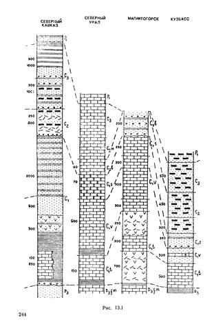
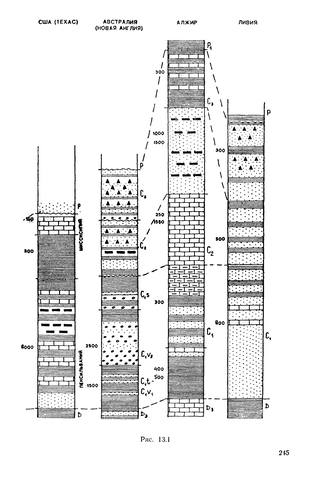
Now although they are talking about North American rocks in particular, the mechanism to which they attribute them would clearly be global, since it involves global changes in sea-level; hence it would explain all the characteristic cyclothems of the Carboniferous, including those of Donetsk. But with that, I do not agree. If the layers of the Carboniferous have been deposited on account of fluctuations in the level of the sea, they correlate with the all world. But this is not observed. Here is the summary of the stratigraphic column from the textbook of historical geology :
Signature over the column: Western Europe, Moscow, Ulyanovsk (Russia), the Donets Basin, the North Caucasus, Northern Urals, Magnitogorsk (Russia), the Kuznetsk basin (Russia), Texas, Australia (New England), Algeria, Libya.As we can see, there is no correlation. Edited by Serg-antr, : No reason given.
|
||||||||||||||||||||||||||||||
|
Serg-antr Junior Member (Idle past 3479 days) Posts: 23 From: Ukraine Joined: |
No, think about this. I do not mean "the same", but a correlation. Certainly rocks can be different depending on environments, but the boundaries between layers should correlate in all the world. After all, the sea level fluctuations necessarily lead to changes in the rocks. Remember that those places would not all be exactly at the same level. One of them could perfectly well be underwater while the other was dry land. What changes is the sea level, in each particular place the depth to which it was submerged (or wasn't) would be a function of that (and of local subsidence and uplift, if any). And even when two of them are both below (or above) sea-level, the nature of the sediment would depend on local factors, there's no reason why you shouldn't have limestone in one place but shale in another, or peat swamps in one place and a river delta in the other. So we wouldn't expect the stratigraphy to look the same in two different places.
The rest of the answers later, sorry, I am very busy.
|
||||||||||||||||||||||||||||||
|
Serg-antr Junior Member (Idle past 3479 days) Posts: 23 From: Ukraine Joined: |
You say that the uplifts were there "according to geologists." Can you please tell us who these geologists are and provide references to their work? Here are the links and citations.
Quantification of the control of sequences by tectonics and eustacy in the Dniepr-Donets Basin and on the Russian Platform during Carboniferous and Permian A comparison of local and global second-order stratigraphic sequences, allowing an estimation of the ratio of the importance of eustatic to tectonic processes controlling subsidence in each basin, demonstrates that eustacy controlled sedimentation in the Moscow Basin and tectonics prevailed in the Dniepr-Donets Basin. Dnieper-Donets depression , , . --- "For coal deposits typical is rhythm, which is a consequence of pulsating tectonic movements during which uplift interspersed with subsidence." More in this thesis ‘ (it is in Ukrainian, I can not to translate into English) specify the nature of these motions.
How do you know it's a flood layer and not just a normal marine layer? I'm not saying that this is the flood deposits, I'm trying to figure out whether they could be formed by the flood.
But Bishop Ussher was a great scholar, and you are not, so rather than just asking us to take your word for it maybe you could provide some, oh, I don't know, evidence in support of your position? How long ago did time become relative? We know that a hundred years ago was the year 1912, and a thousand years ago was the year 912, and two thousand years ago was the year 12, and three thousand years ago was the year 989 BC, and so forth, but you're claiming that at some point we don't actually know how long ago anything was. How far back in time do we stop knowing how long ago things were because "time is always relative"? How was this fact established? How come no one but you knows about this? We can not say anything about the duration of events, especially in the distant past (beyond the historical period), not knowing the properties of time. And that time has properties that can be changed, and not only at the quantum level, as far as I know, has already proven physics. About the dynamical inhomogeneity of time can be found for example in the article written by my fellow countrymen. Time, what is it? Dynamical Properties of Time. Quote from there:" Thus, any material system is capable to influence the course of time in that region of space, where it is placed."Perhaps because an ignorance of the properties of time now a mess with the dating, such as the age of dinosaur soft tissue that could not survive in the soil for more than 10,000 years (Schweitzer MH, Zheng W, Organ CL, et al. Biomolecular characterization and protein sequences of the Campanian hadrosaur B. canadensis / / Science. 2009 May 1, 324 (5927) :626-31) How is the limestone being deposited on the floors of shallow quiet seas today different from the limestone layers of the Donets basin? Today the limestone is not formed, now formed the lime mud. The lime mud can accumulate over time but can be collected from a large area, and sorted by flow. As a result from this the limestone "stream" may be similar to the limestone "many years."
But you said that erosion broke up the coal layers. If the layers of the Carboniferous were uplifted then only the top layer would be exposed. Erosion could not affect the still deeply buried coal layers. Yes, the continental erosion dissects the terrain and makes intermittent horizontal layers, but marine clastic flow washes away the large width of rocks parallel to the horizon.
And the layers above the coal layers could not have been eroded away down to the coal layers because, obviously, they're still there. Or were you trying to say something else when you said that erosion broke up the coal layers?
Unusual in the sense that there is no evidence that it ever happened. Maybe the coal layers can be the proof of it.
Why wait? Let's consider the neighboring regions now. How did the layers of the Donets basin bob up and down like a pogo stick while the adjacent layers did nothing? Or is it your idea that all the layers around the world were bouncing up and down in synchrony?
No, my idea is that they are transferred, sorted, accumulated, eroded powerful flow.
I think you're going to have to explain to us in English just what you think each diagram is showing. Do not understand the question. Regarding the Carboniferous period diagram this shows only the names of stages.
|
||||||||||||||||||||||||||||||
|
Serg-antr Junior Member (Idle past 3479 days) Posts: 23 From: Ukraine Joined: |
But thin layers of coal are not. This is why the Ocean Drilling Project never finds any coal. Because these layers are tightened by tectonic conveyor into the mantle. Coal shall remain only on the continents.
Why? Is there some sort of probability theory relating to the size of peat swamps of which I was previously unaware? Reality is a such theory. Where in the modern world there are such large homogeneous marshes with perfectly flat terrain how on Donbass?
|
||||||||||||||||||||||||||||||
|
|
Do Nothing Button
Copyright 2001-2023 by EvC Forum, All Rights Reserved
![]() ™ Version 4.2
™ Version 4.2
Innovative software from Qwixotic © 2024