
|

Understanding through Discussion |
|
|
Register | Sign In |
|
QuickSearch
| Thread ▼ Details |
|
Suspended Member (Idle past 1472 days)  Posts: 35298 From: Nevada, USA Joined: |
|
Thread Info
|
|
|
| Author | Topic: The Geological Timescale is Fiction whose only reality is stacks of rock | |||||||||||||||||||||||||||||||||||||||||
|
edge Member (Idle past 1734 days)  Posts: 4696 From: Colorado, USA Joined: |
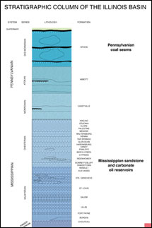
I've been looking for a stratigraphic column like this for some time now to present showing the actual state of affairs when it comes to the geological record.
This is a realistic column showing how rocks are added to the geological record during the Paleozoic in W Illinois.
As you can see, the record mostly consists of gaps. They are like sections of a tape (geological time) that either recorded nothing or were erased (by erosion). These gaps are indeed due to non-deposition and/or erosion of sediments and rocks that were deposited during the gaps; and are typical of continental sedimentation. Basically, there are four separate packages of rocks all separated by unconformities. The column even shows schematically how the base of each package fills in pre-existing topography. Compare that to a more typical section, such as the ones that Faith is accustomed to dealing with:
In this case, unconformities are usually shown with a wavy line between sedimentary units, or as in this case, not even that. The point is that erosion is an important part of the geological record, particularly in continental areas, and what we see in the literature often ignores this fact. Erosion leaves behind a topography (landscape) that is later buried and preserved. Hope this helps, but it is kind of hard to wrap ones mind around it if you can't think in the time dimension.
|
|||||||||||||||||||||||||||||||||||||||||
|
Admin Director  Posts: 13038 From: EvC Forum Joined: Member Rating: 2.1 |
Some help interpreting this chart would be useful:
Is there a higher quality version of this chart? The text is very difficult to read. Here are my interpretations, please correct as necessary. Is it correct that the left side of the chart is just the geological periods, provided as a reference? And to the right of the geological periods are the stratigraphic details from different locations in western Illinois, namely around Colchester, around Warsaw/St. Louis (which are 140 miles apart), and around St. Clair/Moccasin Springs? (The layers at the very top of the diagram mention no location.) At each of these locations mentioned the geographic periods that have no layers are simply not represented at that location. Either layers deposited during those periods were later eroded away, or no layers were deposited for those periods, or some combination of deposition then erosion then deposition then erosion, etc., leaving behind what we see today. So at Colchester (the layers about a third of the way down the diagram) some Pennsylvanian layers are present, but nothing from before that. What is beneath those layers? Igneous base rock? In any case, this means that the interpretation of modern geology is that in the geologic periods before the Pennsylvanian that either nothing was deposited at this location, or whatever was deposited was later eroded away down to bedrock. Then during the Pennsylvanian the layers we currently see were deposited. There were once sedimentary layers above what we see now at Colchester, but those have been eroded away. What we know about them can only be implied from locations where those layers were not eroded away, or possibly by their sedimentary remains at some other location. And 30 miles west in Warsaw and over a hundred miles south in St. Louis there are no Pennsylvanian layers, but there are older Mississippian layers and beneath them even older Devonian layers. Possibly the layers seen at Colchester were deposited here too but were later eroded way. Alternatively there might have been no deposition in this location during the Pennsylvanian. There's not enough information in the diagram to tell. And around Moccasin Springs (200 miles south of Warsaw and 50 miles south of St. Louis) there are no Pennsylvanian, Mississippian or Devonian layers, but there are older Silurian layers and beneath those even older Ordovician layers. If there were ever Quarternary, Pennsylvanian, Mississippian or Devonian layers at this location, there is not enough information in the diagram to tell. Maybe layers were deposited during some or all of those time periods and later eroded away, maybe not. This diagram is even more difficult to read and needs a better version:
Edited by Admin, : Clarification.
|
|||||||||||||||||||||||||||||||||||||||||
|
edge Member (Idle past 1734 days) Posts: 4696 From: Colorado, USA Joined: |
Is there a higher quality version of this chart? The text is very difficult to read.
I don't know of a higher quality image. Most stratigraphic columns are not presented this way, so I took the only one I could find. Here are my interpretations, please correct as necessary. Is it correct that the left side of the chart is just the geological periods, provided as a reference? On the left is a geological time scale, but there is a separate column for major transgressional episodes. And yes, they actually have names like Tippecanoe and Kaskaskia. Each of these transgressions is represented in the graphic column on the right, showing the rocks deposited during each transgression. There are 4 major transgressions in the Phanerozoic all represented by 4 sets of blobs on the diagram.
And to the right of the geological periods are the stratigraphic details from different locations in western Illinois, namely around Colchester, around Warsaw/St. Louis (which are 140 miles apart), and around St. Clair/Moccasin Springs? (The layers at the very top of the diagram mention no location.)
Those names are actually the names of geological formations, except for the Colchester No. 2 which is a coal seam.
At each of these locations mentioned the geographic periods that have no layers are simply not represented at that location. Either layers deposited during those periods were later eroded away, or no layers were deposited for those periods, or some combination of deposition then erosion then deposition then erosion, etc., leaving behind what we see today.
This is exactly correct. The gaps are time periods where there is no geological record. This is the point that I was hoping to show. Time is moving from bottom to top and parts of the time there were rocks being deposited in this part of Illinois, or else there were rocks and they were eroded. There is another dimension in this diagram that is helpful. The graphic part is to the west on the left and to the east on the right. The little notches on top of the blobs and the tabs on the bottoms of the blogs show how channels were cut into the tops and then filled later during the next transgression. The second illustration was more of a traditional stratigraphic column which I will replace with this more familiar one:
You can see how the formations are in direct contact to each other, for the most part with a straight (and flat) line. While this is accurate, there is so much more information in the Illinois column that we are looking at. However, traditionally, the contacts between formations in this type of column are shown as wavy when there is an unconformity.
|
|||||||||||||||||||||||||||||||||||||||||
|
Dr Adequate Member (Idle past 312 days)  Posts: 16113 Joined: |
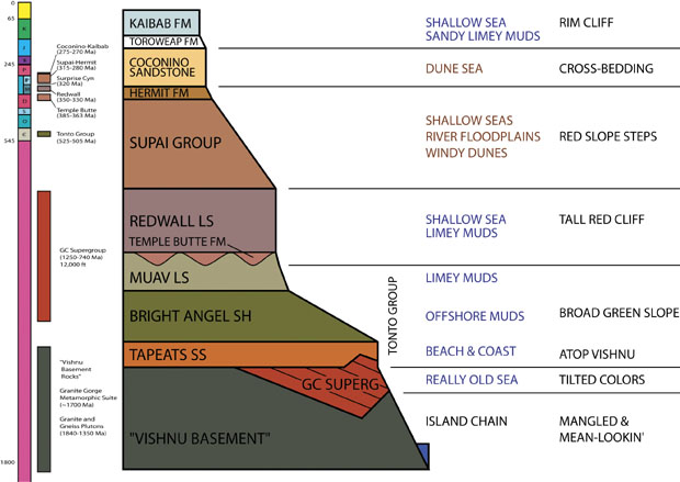
And to the right of the geological periods are the stratigraphic details from different locations in western Illinois, namely around Colchester, around Warsaw/St. Louis (which are 140 miles apart), and around St. Clair/Moccasin Springs? (The layers at the very top of the diagram mention no location.) At each of these locations mentioned the geographic periods that have no layers are simply not represented at that location. Either layers deposited during those periods were later eroded away, or no layers were deposited for those periods, or some combination of deposition then erosion then deposition then erosion, etc., leaving behind what we see today. Just to clarify this. Stratigraphic units are often named after particular locations (type localities) where they were first seen or identified, usually because in that location they were on the surface. So, for example, if you look at the cross-section of the Grand Canyon ...
... then Kaibab and Coconino (and so on) are places where the Kaibab Formation, or the Coconino sandstone (and so on) can readily be found. But these formations extend laterally, which is why you can find them all at the Grand Canyon. Edited by Admin, : Replace image with higher quality version.
|
|||||||||||||||||||||||||||||||||||||||||
|
jar Member (Idle past 422 days)  Posts: 34026 From: Texas!! Joined: |
Just a couple questions for clarification.
In the images below we are seeing both erosion and deposition going on at the same time.
Materials are being moved from higher areas and deposited in lower areas and at the same time those lower areas are also being selectively eroded. Is that correct? And in the following picture we are seeing sections from one location not from several different locations.
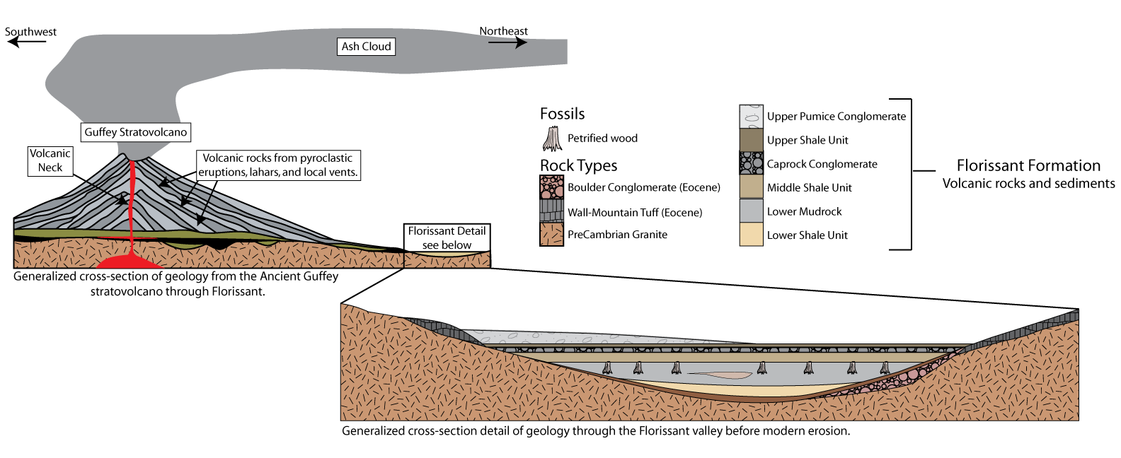
The gaps simply represent material that is missing and the intersections of those areas where there is material in reality fit together but with unconformities. Is that correct? Are we seeing that the layers in that column really are not flat and smooth and do show internal signs of erosion and deposition? Also do you have anything that shows the original size and heights of the Guffey Strato-Volcanoes related to their heights today? That may help explain part of the process. Edited by jar, : fix backgroundMy Sister's Website: Rose Hill Studios
|
|||||||||||||||||||||||||||||||||||||||||
Faith  Suspended Member (Idle past 1472 days) Posts: 35298 From: Nevada, USA Joined: |
I keep trying to say that this is NOT about how landscapes form, it's about the problem of getting from a landscape to a rock. You all keep giving information about landscapes forming. Edge did include an illustration that supposedly says something about getting to a rock from a landscape but not only is it too hard on my eyes* to spend much time on it, I also don't see how it makes his point.
I've been hoping to find a way to say better what I mean. I certainly see the problem when I think about it, thinking particularly about stacks of flat rocks one on top of another and trying to make sense of the idea of landscapes in those rocks. Unfortunately I've said it already about as well as I can, and there's no point in repeating it. But the usual questions occur so I'll just list them again:
Yes I know, this isn't going to make my case, you want something you call "evidence," despite the fact that your evidence doesn't make your case either, just the usual conjectures you make mentally into facts. There's no way I can just point to an absurdity and call it an absurdity because it's so thoroughly accepted as How Things Were. Anyway, there's no point in continuing to try to prove how landscapes form; that is not the problem I'm posing here. I guess this is the best I can do for now so for me this is a summation of the thread. =========*My monitor's buttons are too high tech for me. Fiddling with them usually makes the problem worse. Edited by Faith, : No reason given. Edited by Faith, : No reason given. Edited by Faith, : No reason given. Edited by Faith, : No reason given.
|
|||||||||||||||||||||||||||||||||||||||||
|
NoNukes Inactive Member |
I keep trying to say that this is NOT about how landscapes form, it's about the problem of getting from a landscape to a rock. You all keep giving information about landscapes forming. That may be the information you are getting now, but how many times prior to this point has lithification been discussed? In my opinion, your comment is completely without merit.
but not only is it too hard on my eyes* to spend much time on it, I also don't see how it makes his point. Say what? You haven't looked at it, but it's wrong?
Yes I know, this isn't going to make my case, you want something you call "evidence," despite the fact that your evidence doesn't make your case either, just the usual conjectures you make mentally into facts. For the most part, answering your questions simply requires describing how things might work rather than proving any such thing. After all, your premise is that the entire non-Flood scenario is impossible. It is going to be nearly impossible to offer real evidence to you because once it becomes time to cite that evidence, you are not going to make any attempt to read the material. What would you have us do in such a case? Edited by NoNukes, : No reason given. Under a government which imprisons any unjustly, the true place for a just man is also in prison. Thoreau: Civil Disobedience (1846) History will have to record that the greatest tragedy of this period of social transition was not the strident clamor of the bad people, but the appalling silence of the good people. Martin Luther King I never considered a difference of opinion in politics, in religion, in philosophy, as cause for withdrawing from a friend. Thomas Jefferson
|
|||||||||||||||||||||||||||||||||||||||||
|
Dr Adequate Member (Idle past 312 days) Posts: 16113 Joined:
|
Why should there be one landscape on top of another at all if standard Historical Geology is correct? Because deposition can go on happening in the same place.
Especially in marine strata why are there strata at all ever? Because conditions of deposition can change, either because the environment changes or because plate tectonics moves the plates the sediment is deposited on.
Why don't they just blur together .... We often do see one sediment grading into another.
or a new marine environment just add to the previous? Didn't follow that, sorry.
Or terrestrial where edge keeps insisting they aren't as extensive as the marine environments? Why should they pile one on top of another at all ever? Well, if you have a depositional environment, say a sedimentary basin, then layers of sediment are going to accumulate.
Please spare me the "why not?" Well, it is very hard for normal people to conceive of whatever intellectual difficulties you have that are preventing you from grasping this. It's so normal, it's about water and mud. One feels baffled, like if one was asked "But how could you possibly eat that sandwich? You keep telling me all this stuff about 'putting things in your mouth' but that makes no sense. Why do your shoes fit on your feet but not on your head? You say it has something to do with size, but what? WHY IS THERE MORE THAN ONE TREE IN THE WORLD, ANSWER ME THAT!?!"
I can see how you can get A rock from A landscape but the idea of getting a whole stack of rocks one on top of another all representing a stack of landscapes is weird. Well, if you can get from a landscape to a rock, then you can get from a stack of landscapes to a stack of rocks.
Why should there be a dividing line/rock between landscapes? Why a different sediment? It's like each rock puts up a barricade between landscapes or time periods, differentiating them sharply from one another. Well, usually the same sediment is piled on the same sediment, which is why we get formations which are hundreds of feet thick. But sometimes circumstances change: say, the climate changes from hot to cold, or the sea comes in, or a delta changes its position, and then you get different sediment being deposited.
Why should the rocks be so predominantly flat and straight in both marine and terrestrial strata? Flat and straight is how sediment is predominantly deposited.
That is, why should an "environment" or a landscape, which is naturally lumpy, bumpy, hilly and dippy, EVER boil down to a flat rock?: EVER? Let alone one rock after another to a depth of miles? What law requires that the rock be eroded to flatness before it lithifies? Why don't lumpy rocks lithify? Why doesn't the lumpiness of the landscape show up in the strata at all? Yes I note your "lakes" or "basins" in your recent illustrations. I don't believe them, they are extremely rare exceptions and I don't believe them after arguing my point about flatness for years. No. I've produced photographs of the extreme straightness and flatness I'm talking about. And please don't trot out any other extremely rare exception, or try to pretend a little irregularity in the surface of a rock proves me wrong: the strata are flat! (Make it "flattish," make it "somewhat flat," I don't care, the standard depiction is flat. The strata in the Grand Canyon are flat. Yes, with the occasional erosion between layers that you all make way too much of.) We are not obliged to explain things that you made up. The explanation is that you made it up. After having made the same mistake for years, you refuse to believe all the evidence you've been shown against it. Well, you are a creationist, and t's a free country.
|
|||||||||||||||||||||||||||||||||||||||||
|
Faith Suspended Member (Idle past 1472 days) Posts: 35298 From: Nevada, USA Joined: |
Why should there be one landscape on top of another at all if standard Historical Geology is correct? Because deposition can go on happening in the same place. Not with the regularity necessary to producing a stack of strata over hundreds of millions of years. Also there is no reason at all why a landscape should ever be completely obliterated by deposition, but the strata require it to be completely obliterated, with just a few little clues that it ever existed at all so of course you have to make up that it was completely obliterated, just typical made-up rationalization. To be expected but how nice it would be if just once you saw the point I'm making. It won't happen but how nice it would be...
Especially in marine strata why are there strata at all ever? Because conditions of deposition can change, either because the environment changes or because plate tectonics moves the plates the sediment is deposited on. And of course since it's needed to rationalize what is seen in the strata, therefore that's what must have happened. No, it makes no sense that a marine encroachment should end up as a rock on top of which another one forms, or something else entirely forms.
Why don't they just blur together .... We often do see one sediment grading into another. Very very rarely. And not at the boundary between "time periods." However, when I say blur I don't mean "grading into" I mean NO DIFFERENCE between. There is no reason whatever that there should be completely different environments for different eras of time. The evolved creatures should just join with the earlier forms without anything to mark the changing times. And besides, when an environment starts changing into a rock because of being buried everything in it has to die. Yeah yeah yeah, move somewhere else. Where? Where are their fossils except in THIS rock representing THIS environment?
or a new marine environment just add to the previous? Didn't follow that, sorry. No need for the environment to turn into a rock, to die. Forget the rock, just let the creatures evolve so that whole genera are fossilized together instead of neatly separated. That's what a realistic scenario would have been.
Or terrestrial where edge keeps insisting they aren't as extensive as the marine environments? Why should they pile one on top of another at all ever? Well, if you have a depositional environment, say a sedimentary basin, then layers of sediment are going to accumulate. Ah yes, with a rock or rock-in-progress to end one era while the next is forming, and without even a shred of evidence of any basin, and the usual separation of the species as if Time/History and Nature followed some kind of perfect plan.
Please spare me the "why not?" I'll repeat it: Please spare me the "why not?"
I can see how you can get A rock from A landscape but the idea of getting a whole stack of rocks one on top of another all representing a stack of landscapes is weird. Well, if you can get from a landscape to a rock, then you can get from a stack of landscapes to a stack of rocks. Can't you ever just take anything I say straight? I'd have said that if I thought it, but I don't. A stack of rocks from a stack of landscapes actually poses a much more difficult problem than just one rock from one landscape. It's a tedious explanation but I'll get back to it if I can.
Why should there be a dividing line/rock between landscapes? Why a different sediment? It's like each rock puts up a barricade between landscapes or time periods, differentiating them sharply from one another. Well, usually the same sediment is piled on the same sediment, which is why we get formations which are hundreds of feet thick. But sometimes circumstances change: say, the climate changes from hot to cold, or the sea comes in, or a delta changes its position, and then you get different sediment being deposited. Lot of "changes" seem to have occurred at more or less regular intervals over those hundreds of millions of years, almost like clockwork, all with changes in sediment, and with a remarkable suddenness from one to another too. Oh but it only looks sudden, right, cuz here we can invoke "erosion" to explain the apparent suddenness, the lack of gradation. Rationalization is a wonderful scientific method. Remarkable. Also, why shouldn't the landscape and fossil life in both rocks in the strata be identical? Why the regularity in changing time spans and rock contents? Well, just so it doesn't look TOO regular we can refer to "unconformities" where a particular sediment didn't get deposited.
Why should the rocks be so predominantly flat and straight in both marine and terrestrial strata? Flat and straight is how sediment is predominantly deposited. Dry sediment? And what about erosion? Why so consistently flat and straight as if there were some rule that erosion would have to totally obliterate a mountain range before anything could be deposited in its place. (Tapeats sandstone, VERY VERY nice and flat in most pictures, on both top and bottom, on top of "Great Unconformity" which is said to be the root of a former mountain range. (No PaulK, I haven't forgotten the monadnocks such as the quartzite penetrating deep upward. Very rare occurrence but not impossible to explain as occurring after the sediments above were already there.
That is, why should an "environment" or a landscape, which is naturally lumpy, bumpy, hilly and dippy, EVER boil down to a flat rock?: EVER? Let alone one rock after another to a depth of miles? What law requires that the rock be eroded to flatness before it lithifies? Why don't lumpy rocks lithify? Why doesn't the lumpiness of the landscape show up in the strata at all? Yes I note your "lakes" or "basins" in your recent illustrations. I don't believe them, they are extremely rare exceptions and I don't believe them after arguing my point about flatness for years. No. I've produced photographs of the extreme straightness and flatness I'm talking about. And please don't trot out any other extremely rare exception, or try to pretend a little irregularity in the surface of a rock proves me wrong: the strata are flat! (Make it "flattish," make it "somewhat flat," I don't care, the standard depiction is flat. The strata in the Grand Canyon are flat. Yes, with the occasional erosion between layers that you all make way too much of.) Needs repeating.
|
|||||||||||||||||||||||||||||||||||||||||
|
Admin Director Posts: 13038 From: EvC Forum Joined: Member Rating: 2.1 |
I think this would be a very helpful clarifiation. This is from Jar's Message 785:
jar in Message 785 writes: And in the following picture we are seeing sections from one location not from several different locations.
The gaps simply represent material that is missing and the intersections of those areas where there is material in reality fit together but with unconformities. Is that correct? Are we seeing that the layers in that column really are not flat and smooth and do show internal signs of erosion and deposition? This was my original interpretation, but then I became uncertain and wondered if the top of each of the four stratigraphic columns represents a modern topography at four different locations in western Illinois. They all slope downward toward the west, so perhaps that's because they're bounded on the west by the Mississippi River?
|
|||||||||||||||||||||||||||||||||||||||||
|
Dr Adequate Member (Idle past 312 days) Posts: 16113 Joined: |
Not with the regularity necessary to producing a stack of strata over hundreds of millions of years. Assertion is not argument. Why shouldn't a particular location be depositional for long periods of time? For example, if it's at the bottom of the sea?
Also there is no reason at all why a landscape should ever be completely obliterated by deposition ... If by "obliterated" you mean "obliterated" then you are quite right, which is why this never happens. If you mean "covered", then yes, enough deposition will cover anything.
And of course since it's needed to rationalize what is seen in the strata, therefore that's what must have happened. Faith, we can see depositional environments changing and we can measure continental drift. Changes in what sediment are deposited must happen. If we couldn't find any changes, if every given location showed that the same sediment had been settling on it for ever, then you would have found a strange anomaly that geologists couldn't explain.
Very very rarely. No, often. Stop making shit up.
There is no reason whatever that there should be completely different environments for different eras of time. Yes there is: environments change.
The evolved creatures should just join with the earlier forms without anything to mark the changing times. And besides, when an environment starts changing into a rock because of being buried everything in it has to die. Yeah yeah yeah, move somewhere else. Where? Where are their fossils except in THIS rock representing THIS environment? I can attach no meaning to this: would you like another crack at it?
No need for the environment to turn into a rock, to die. Forget the rock, just let the creatures evolve so that whole genera are fossilized together instead of neatly separated. That's what a realistic scenario would have been. Or this.
Ah yes, with a rock or rock-in-progress to end one era while the next is forming, and without even a shred of evidence of any basin, and the usual separation of the species as if Time/History and Nature followed some kind of perfect plan. Whereas you suppose that the fossils were arranged as though the waters of the Flood were following what you call "a perfect plan". Myself, I would not go so far: evolution and extinction are not a perfect plan, and it is they that we see written so clearly in the fossil record.
Lot of "changes" seem to have occurred at more or less regular intervals over those hundreds of millions of years, almost like clockwork, all with changes in sediment, and with a remarkable suddenness from one to another too. Oh but it only looks sudden, right, cuz here we can invoke "erosion" to explain the apparent suddenness, the lack of gradation. Rationalization is a wonderful scientific method. Remarkable. 'm not sure what you're talking about. Probably not geology, though.
Dry sediment? Apart from the surface ripples and dunes, the wind does flatten out dry sediment.
And what about erosion? Why so consistently flat and straight as if there were some rule that erosion would have to totally obliterate a mountain range before anything could be deposited in its place. There is such a rule. It's called the law of fucking gravity, Faith. Water washes sediment down, not up; gravity pulls sediment down, not up. Sediment is going to come from the mountains to the plains below and not vice versa.
Needs repeating. Needs to have a stake driven through its heart and be buried at a crossroads so that this stupid zombie lie will finally rest quiet instead of shambling through this thread making moaning sounds and drooling. Edited by Dr Adequate, : No reason given.
|
|||||||||||||||||||||||||||||||||||||||||
|
edge Member (Idle past 1734 days) Posts: 4696 From: Colorado, USA Joined: |
And in the following picture we are seeing sections from one location not from several different locations.
Actually, it's almost like a cross-section. Notice the 'West' and 'East' labels at the bottom of the diagram.
The gaps simply represent material that is missing and the intersections of those areas where there is material in reality fit together but with unconformities.
Yes in 3D space all of the units would be stacked. This diagram includes time as a dimension.
Is that correct? Are we seeing that the layers in that column really are not flat and smooth and do show internal signs of erosion and deposition?
The could locally be flat, but as the thicknesses of the formations and little channel slots show, these are continental sediments. They do not persist across the continent.
Also do you have anything that shows the original size and heights of the Guffey Strato-Volcanoes related to their heights today? That may help explain part of the process. I doubt that a study has been done. However, for various reasons, we could say that it was between 500 and 2000m above the base of the volcano. Edited by Admin, : Add quote of text that the last response was replying to.
|
|||||||||||||||||||||||||||||||||||||||||
|
PaulK Member Posts: 17827 Joined: Member Rating: 2.3
|
quote: Regularity is not necessary because we have hundreds of millions of years. No terrestrial locations have seen continuous deposition - that is for the sea floor, where you would expect it.
quote: There is also nobody who says that landscapes are "completely obliterated by deposition". Covered over, maybe but isn't that what deposition ought to do ?
quote: Following the evidence is not a rationalisation, Faith.
quote: You say that it is rare but you don't offer any reason to think so. And since there are no convenient markers for the boundaries between time periods, how can we say what happens there ? The third point is obviously silly. If there was no difference we wouldn't have a boundary between formations which is what you usually mean. (And if you mean something else I want to know why the Green River varves don't count)
quote: You think that environments should remain constant for hundreds of millions of years ? It's bizarre - at the top of the post you complain that constant deposition is impossible, and now you insist that we should expect it.
quote: Aside from being a confused mess I have to ask how we can possibly give an answer that you will find satisfactory when everything is abstract. Especially as I have already tried that. Give us a concrete example of what you mean.
quote: You will have to explain why you find this realistic. I don't find it realistic that nature should only do what you find "necessary" or that genera should always be found fossilised together - especially when your "realistic" scenario doesn't seem to allow for fossils to even exist.
quote: I am afraid that this is just another case where what "seems" to be true to you has no basis in reality.
quote: Of course it doesn't have to be obliterated as you admit. However erosion does tend to level mountains and - on land - sediment is not often deposited on high places. So there will be a definite bias in favour of flattening mountains.
|
|||||||||||||||||||||||||||||||||||||||||
|
edge Member (Idle past 1734 days) Posts: 4696 From: Colorado, USA Joined: |
This was my original interpretation, but then I became uncertain and wondered if the top of each of the four stratigraphic columns represents a modern topography at four different locations in western Illinois.
They represent the topography from west to east after erosion to those levels. They represent terrain, aka 'landscape' which is then buried by the next transgression.
They all slope downward toward the west, so perhaps that's because they're bounded on the west by the Mississippi River?
The Illinois Basin occurs to the east, so that is where the sediments are thicker, especially for the Tippecanoe sequence. Erosion occurred earlier at the edges of the basin.
|
|||||||||||||||||||||||||||||||||||||||||
|
Faith Suspended Member (Idle past 1472 days) Posts: 35298 From: Nevada, USA Joined:
|
I don't see any reason for me to continue this thread. I've made about the best case I can make to this point. It's not good enough of course, but then it never is, is it?
I also don't see any relevance to Admin's contribution and the discussion about that.
|
|||||||||||||||||||||||||||||||||||||||||
|
|
Do Nothing Button
Copyright 2001-2023 by EvC Forum, All Rights Reserved
![]() ™ Version 4.2
™ Version 4.2
Innovative software from Qwixotic © 2024


 (1)
(1)