
|

Understanding through Discussion |
|
|
Register | Sign In |
|
QuickSearch
| EvC Forum active members: 64 (9163 total) |
|
| |
| ChatGPT | |
| Total: 916,410 Year: 3,667/9,624 Month: 538/974 Week: 151/276 Day: 25/23 Hour: 1/4 |
| Thread ▼ Details |
|
Suspended Member (Idle past 1465 days)  Posts: 35298 From: Nevada, USA Joined: |
|
Thread Info
|
|
|
| Author | Topic: Motley Flood Thread (formerly Historical Science Mystification of Public) | |||||||||||||||||||||||||||||||||
|
Capt Stormfield Member  Posts: 429 From: Vancouver Island Joined: |
For "depositional environments" to be the basis of the strata requires that you ignore all the far more common environments that AREN'T flat and choose only those that are. Wow.Just wow.
|
|||||||||||||||||||||||||||||||||
Faith  Suspended Member (Idle past 1465 days) Posts: 35298 From: Nevada, USA Joined: |
Your "wow" doesn't convey much but perhaps you mean to say that my statement is odd, and I can see how it could seem odd. But I didn't mean Geologists ignore it, I was thinking of all the efforts here to find the flattest possible natural landscape as their idea of how the strata would have formed. Salt flats, beaches, fields, plains and so on. Ad actually I'm not totally sure that Geologists don't think the same way since edge has joined in the same discussion as if he did. I've noticed, however, that you don't bother much about context, you just read according to your own notions.
|
|||||||||||||||||||||||||||||||||
|
Capt Stormfield Member Posts: 429 From: Vancouver Island Joined: |
...all the efforts here to find the flattest possible natural landscape as their idea of how the strata would have formed. Salt flats, beaches, fields, plains and so on. Yeah, it's weird how normal people think flat strata form from flat geological features. As opposed, I suppose, to thinking they would form from the pointy parts that are being eroded down into those flat places...Oh, wait....
|
|||||||||||||||||||||||||||||||||
|
Faith Suspended Member (Idle past 1465 days) Posts: 35298 From: Nevada, USA Joined: |
So reading your above words we can see that you were claiming that fractures in strata two miles above the canyon deepened and eventually became the Grand Canyon. But nothing about the sinuous shape of canyon suggests following fractures in the rock, which tend to be straight. That's maybe true enough in short lengths. But you can't always break anything straight across just by pulling it apart, you get it breaking in all kinds of directions you'd prefer it didn't and in more than one place. I'm thinking of a ball of dough or of clay. Why would you think I'm claiming the cracks created the whole river anyway? I think the strain caused by the uplift cracked the strata over the uplift, that's all I've claimed. Perhaps it cracked in many places too and then one or a collection of cracks became the canyon. The river dips south around the uplift to a level lower than the highest part but not the lowest. If it formed from ground level according to your view, wouldn't you expect it to go completely around the uplift rather than through it at any height? From ground level the uplift remains a barrier it's hard for you to explain. But starting from above it all it's got some issues but it isn't impossible. Probably the whole uplift had cracks in it and water running down the south side opened up the nearest one on the incline or something like that. I mean we're all speculating here, so why not?
But no fractures. And let's not forget that wet and malleable rock is your made-up idea anyway. Why did you say "no fractures?" Where did that come from. As for "making up" wet and malleable rock, what else would it be after being deposited by the Flood?:
|
|||||||||||||||||||||||||||||||||
|
Faith Suspended Member (Idle past 1465 days) Posts: 35298 From: Nevada, USA Joined: |
Well, the strata extend across great areas of land where today there are hills and valleys and mountains and so on. They are stacked miles deeps across such extended areas. Hundreds of cores from the American Midwet covering thousands of square miles all show the same series of strata, one on top of another, flat flat flat. Where did the mountains go?: How do you explain such flatness across most of a continent? I can explain it but I don't see how the standard model/Time Scale can. So now everybody is focused on the separated flat areas that cover small areas by comparison. And aren't flat enough anyway.
Oh and by "normal people" I'm sure you mean those brainwashed by the establishment point of view. Edited by Faith, : No reason given. Edited by Faith, : No reason given. Edited by Faith, : No reason given.
|
|||||||||||||||||||||||||||||||||
|
Faith Suspended Member (Idle past 1465 days) Posts: 35298 From: Nevada, USA Joined: |
But directly addressing your argument, why would these fractures occur only where the canyon is and nowhere else on the uplift? I think they probably did, lots of them, but the water found a lower point to major in as it were. Not the lowest, just lower. The lowest is what your scenario would seek, but that didn't happen. And the water then kept opening it further at lower points, which look like happen to be along the western side flowing north at that point. What is the explanation from your model how the river got over the uplift? Edited by Faith, : No reason given.
|
|||||||||||||||||||||||||||||||||
|
Capt Stormfield Member Posts: 429 From: Vancouver Island Joined: |
...the strata extend across great areas of land where today there are hills and valleys and mountains and so on. It's almost as if the ground had moved around underneath them, rising up and such.
Where did the mountains go? I'd think they got eroded down to the bottom and made the flat strata. Don't worry though, fresh ones popped up in other places. They're in the process of eroding down into the new flat areas that some gormless creationist will be puzzled about in a billion years or so.
So now everybody is focused on the separated flat areas that cover small areas by comparison. You realize they're not done yet, right? Kind of by definition, if you can see them. Edited by Capt Stormfield, : typo
|
|||||||||||||||||||||||||||||||||
|
Faith Suspended Member (Idle past 1465 days) Posts: 35298 From: Nevada, USA Joined: |
Thin sheets of water running across a plateau do not create meanders, Your method of slogging through the posts from far back in the thread has the disadvantage of repeating things a million times that have long since been answered though you won't discover that for days. You repeated I don't know how many times that the Painted Desert hill is not a "mountain" days after I'd stopped calling it a mountain. You even went to lengths to prove it which you could have spared yourself. Now you are perseverating on this sheet of water after I've said many times that no, a sheet doesn't form a meander, streams form meanders, and I always said that anyway.
...and water levels dropping at only 1.5 inches/minute are not going to create a significant flow of water anyway. Um, we're talking water as far as the eye can see. It's dropping at the rate of 90 inches or 7.5 feet an hour. That's a HUGE amount of water draining away. At first it may be quiet enough, just steadily dropping. But it's going to pick up speed in places when it starts draining off land. Just as a tub drains the lower water first that must be what's happening here too, if the ocean floor has dropped. It's all going to drain from the bottom, so at first it would just be a matter of the level dropping teadily. Then when earth is exposed, or the stack of sediments that has just been laid down, it gets more complicated.. Give it a few days to be seriously washing away sediments, a couple weeks to be washing away sediments that offer some resistance because they're harder. In the canyon area we're talking probably a few thousand square miles it washes over. When the level gets low enough to be running across a plateau it's still a lot of water at first, a LOT. And it isn't all going to run in the same direction when there are obstacles in its path as there will be when the level gets lower and lower and the sediments are harder and harder, it's going to run faster in some places than others.
Also, this contradicts your other claim above that fractures in the strata two miles above is what created the channel for the Grand Canyon. What contradicts what? The strata were laid down flat so even if they were soft at the top they would fracture when stretched over the uplift. Break up rapidly of course, but the lower you go the more solid the rock There's still strain on lower levels too where the rock is more solid because all the strata were bent up and over the Kaibab uplift.
...and that washing away would have had stages too,... Could you describe these stages? Places it runs faster or slower, places it makes whirlpools, places it pours over a harder layer into a crevasse formed by strata already washed away, places it gets dammed up etd. It's going to pool in some areas eventually, forming the big lakes like Missoula and Lahontan. But that's of course when it has reached today's surface level.
...depending on how steep the exits were that opened up as the water level decreased. Some damming probably occurred in places and then broke and so on. Exits? Now you're imagining some kinds of natural dams were in place that needed breaking through? What is your evidence? See above. It's perfectly logical that all this would occur in the process of draining a huge amount of water full of sediments of different kinds in different stages of hardness, changing directions, getting faster here and slower there and so on and so forth.
Your story continues to be contradictory, contrary to the way water, sediments and rock behave, and completely lacking in evidence. Only on your weird planet. Edited by Faith, : No reason given. Edited by Faith, : No reason given. Edited by Faith, : No reason given.
|
|||||||||||||||||||||||||||||||||
|
Coragyps Member (Idle past 755 days) Posts: 5553 From: Snyder, Texas, USA Joined: |
Indeed, Faith, we all live on a weird planet. But not near as weird as you think. It pretty much always obeys the laws of physics, like pebbles settling out of water faster than silt does.
"The Christian church, in its attitude toward science, shows the mind of a more or less enlightened man of the Thirteenth Century. It no longer believes that the earth is flat, but it is still convinced that prayer can cure after medicine fails." H L Mencken
|
|||||||||||||||||||||||||||||||||
|
Faith Suspended Member (Idle past 1465 days) Posts: 35298 From: Nevada, USA Joined: |
Had in mind getting back to this and almost completely forgot:
Article challenging the lake theory of how the canyon was formed, as shown in the video. I was particularly interested in what its author says about the Kaibab uplift:
Dickinson hopes at least to lay to rest one hypothesis: That an ancient lake carved the canyon through a cascading series of waterfalls... Plus, there's the problem of the Kaibab uplift, a pinch in the Colorado Plateau where the rocks swell up due to underground folding. Sitting near the head of the Grand Canyon, the Kaibab uplift is a 650-foot (250-meter) barrier that any prehistoric lake or river must have carved through before dropping down into the future gorge. The preserved lake beds show water levels were never high enough to cross the uplift, Dickinson said. The next question must be, how did the river cross it? The Flood could cross it, however. But what particularly interested me was his calling it "a pinch in the Colorado Plateau where the rocks swell up due to underground folding." The concept of rocks "swelling up" is something to contemplate, but I imagine it's just a poetic way of saying they got pushed up, but it's the "due to underground folding" that intrigues me since of course I interpret the uplift as the result of the tilting of the Supergroup at the Great Unconformity. He doesn't name the Supergroup but on the cross section that's what is directly beneath the uplift ahd it's a species of folded rocks, caused by tectonic pressure.
Edited by Faith, : No reason given. Edited by Faith, : No reason given. Edited by Faith, : No reason given. Edited by Faith, : No reason given. Edited by Faith, : No reason given.
|
|||||||||||||||||||||||||||||||||
|
Faith Suspended Member (Idle past 1465 days) Posts: 35298 From: Nevada, USA Joined: |
Well, he accused me of something I believe is true of him and not me. OK?
|
|||||||||||||||||||||||||||||||||
|
Percy Member  Posts: 22480 From: New Hampshire Joined: Member Rating: 4.8 |
Faith writes: But I think true nevertheless, and in fact probably the main evidence that the geological column is over and done with.
It has been explained to you many times that this is definitionally impossible. And you've been wrong all those many times you've explained it. But you've never been able to explain how it is wrong. How could the geologic timescale be at an end unless time is at an end. We're currently in the Quaternary period, which extends from about 2.5 million years ago to the present, so the Quaternary, part of the geologic timescale, exists today. Tomorrow will still be the Quaternary, so the geologic timescale will still exist tomorrow. Next week will also still be the Quaternary, so the geologic timescale will still exist next week. Same for next year, and the year after, and the year after that, and so on into the future. The geologic timescale has not come to an end and will not come to an end until we're at the end of time. So you are, by definition, wrong. I anticipate you'll again respond, in effect, "No, you're wrong," but just as you were unable to explain how I'm wrong in this post, you won't be able to explain it in your next post either, because it's definitionally true.
Though I think there's pretty good evidence for it already, just not complete.
What evidence would that be? The Grand Canyon area and the Smith cross section of England but lots of other cross sections where what strata are present are present in blocks and eroded as blocks and deformed as blocks. Later on you define block as a "unit of neatly demarcated strata," but this is pretty ambiguous. And it isn't clear what "what strata are present are present in blocks and eroded as blocks and deformed as blocks" means. But anyway, why do you think this is evidence that the geologic timescale has ended?
That is, we've got all kinds of interestingly stratified geological objects out there from mountains to buttes to hoodoos to the Grand Canyon, all carved by erosion out of what was originally a great expanse of stacked sediments, and it just seems that the layers are mostly all neat and parallel and tight and eroded ONLY, carved ONLY, shaped ONLY after they were all laid down originally horizontally. None of that has anything to do with the geologic column being "over and done with." Oh yes it does. Everywhere the erosion or deformation is shown to have occurred to a block or unit of neatly demarcated strata is evidence of rapid deposition of the strata,... Why do think this is evidence of rapid deposition?
...lack of erosion or deformation until all were laid down, is evidence,... But what is true of the Colorado Plateau is not true of the rest of the world, not even of the regions adjacent to the it. As the USGS webpage on the Colorado Plateau says:
quote: ...though the areas where the whole range of the time scale is present are the best evidence. There is no stratigraphic column anywhere in the world where the entire geologic timescale is represented.
There are many partial stacks in many places, that my favorite Grand Canyon / Grand Staircase is really the only area I know of where they are ALL there. The Grand Staircase region is not an area where "they are ALL there." There were layers above the Claron that are now gone. There are unconformities, i.e., gaps in representation of the geologic column. There is the Great Unconformity representing about a couple hundred million years of the geologic column. The Claron is Holocene or Eocene, recent anyway, and that's probably the best we get anywhere because strata above that would have been too unconsolidated to withstand the receding flood water. Unconformities and gaps are irrelevant to the point I'm making. No, unconformities are not irrelevant to the point you're making. You're arguing that the Grand Staircase region is a complete representation of the geologic timescale. It isn't, because periods of the geologic timescale are not represented.
Rocks below the GU in both the Smith cross section and the GC/GS cross section are included on the cross sections but also not particularly relevant to the point. It all got stacked up and then was eroded and deformed AS A STACK, everywhere it occurred. It's all over and done with. You don't need to say GC/GS because the GC is part of the GS region. Just GS is fine. You're using pronouns ambiguously again. You use "it" three different times referring to two different things. The last use of "it" refers to the geologic timescale, clear from context. What do your other uses of "it" refer to? The geologic timescale is not over and done with. Geology continues to happen, and time has not come to an end.
You've got the wrong reason that the geologic column is conceptual. It isn't because it doesn't exist exactly the same in any one place. It is conceptual because it doesn't exist in any place. It is a framework within which stratigraphic columns can be interpreted. All I care about is the time scale attached to the rocks really,... It would be nice if you cared about getting anything right.
...and it is partial in most places. Stratigraphic columns are incomplete everywhere.
...but nevertheless they... There you go with pronouns again. By "they" do you mean stratigraphic columns? I'll assume you do. Usually pronouns refer back to the nearest or at least grammatically nearest antecedent but I'll try to be aware of the problem. Thank you.
...are always (with the one exception of angular unconformities) found in these straight or at least parallel tight layers whether stacked horizontally or tilted or twisted into a pretzel, layers obviously originally stacked up one on top of another before being eroded into shapes or twisted into pretzels. Not bad, but it isn't clear what you're excepting angular unconformities from, and strata do not always have "tight contacts" (the correct term is sharp contacts). What I'm saying is that the strata in all the columns everywhere, even the most incomplete ones as far as the time scale goes, are always found in blocks of originally horizontal strata, eroded as blocks, deformed as blocks, except for the angular unconformities which put two blocks at different angles to each other. You said this earlier, and it still isn't clear. You define "block" ambiguously. What does "eroded as blocks" mean? What does "deformed as blocks" mean, particularly if you define just a part of a stratigraphic column as a block? It's easy to tell apart strata units at different angles, but if you're dividing stratigraphic columns into blocks, what is your criteria for the division between blocks? Why can't you just use standard geology terminology?
I can use "sharp" if it's really the official term but I've followed other advice about my terminology only to find out I was using it correctly enough already. I can't find anything definitive, like a geology glossary that defines "contact" let alone "sharp contact", but if you enter "'tight contact' geology" into Google Images you won't find any images showing anything like what you're thinking of. If you instead enter "'sharp contact" geology" you'll find precisely what you're thinking of. "Tight contact" is a valid geological term, but it seems to refer to how tightly fragments (like clasts) making up a stratum are in contact with one another. Maybe Edge or Moose will comment.
This is all evidence... It's a description of some of the things that can happen to strata, not evidence. Of course it's evidence, don't be silly. No, it isn't evidence. What you said in Message 284 was this:
Faith in Message 284 writes: Yes I know there are many partial stacks in many places, that my favorite Grand Canyon / Grand Staircase is really the only area I know of where they are ALL there, and yes I know the stacks are local and that the geo column is conceptual because it doesn't exist exactly the same in any one place, but nevertheless they are always (with the one exception of angular unconformities) found in these straight or at least parallel tight layers whether stacked horizontally or tilted or twisted into a pretzel, layers obviously originally stacked up one on top of another before being eroded into shapes or twisted into pretzels. This isn't evidence. It's just an inexact and skimpy statement of a few relatively simple things about geology. You didn't even attempt to make any connection between this statement and your claims, some of which are actually true of the Colorado Plateau, such as the lack of tectonic disturbance. What you did is like saying, "Planes fly people between cities, and that's evidence I flew from Albuquerque to Flagstaff yesterday."
...that the strata were all there before being disturbed in any way, which is evidence for rapid deposition,... What is your evidence for rapid deposition? That the strata were all laid down one on top of another without being eroded or deformed until they were all laid down. Nothing has changed that would make rapid deposition a feasible possibility. Tiny sediments falling out of suspension is an extremely slow process even in quiet water, and in the active water of your waves and tides and inundations tiny sediments would not fall out of suspension.
That suggests there were no time gaps between layers. The unconformities are time gaps between layers.
abe: I mean VISIBLE time gaps, spaces where erosion should have occurred and didn't; I'm not talking about the supposed missing layers or unconformities. /abe You don't seem to be describing anything real. In your mind, what would "VISIBLE time gaps, spaces where erosion should have occurred and didn't" look like?
...for the Flood,...
What is your evidence for the flood? That the strata were all laid down rapidly without time gaps as stated above. abe: and again: I mean VISIBLE time gaps, spaces where erosion should have occurred and didn't'; I'm not talking about the supposed missing layers or unconformities. /abe. You're repeating yourself. Again, there is no evidence for any of this. Much of what you call evidence isn't even possible, and you haven't yet explained what you mean by visible time gaps where erosion should have occurred but didn't.
...and against the Time Scale. What is your evidence against the geologic timescale? That the strata were all laid down rapidly without gaps (I'm not talking about what you call "unconformities, I'm talking about visible gaps where erosion would have occurred; please don't nitpick this, that would miss the point) and eroded or deformed all together after they were all laid down. None of this is even true, and you don't explain how, even if it were true, it would be evidence against the geologic timescale. Today we're in the Quaternary, and tomorrow we'll still be in the Quaternary. It will always be true, at least for the next few million years, that tomorrow we'll still be in the Quaternary. The geologic timescale has not ended. It cannot end unless time ends.
Even where partial... I doubt there's any place in the world where there's a stratigraphic column that fully represents the geologic column. I bet every stratigraphic column is partial OK then let me here say I always have the Geological Time Scale in mind and that's what can be partial, not including all the different periods. The geologic timescale can never be partial. It's conceptual and spans all the time of Earth's existence from 4.6 billion years ago to the present. Naturally you can focus your attention on just some part of the geologic timescale, but the timescale itself is not partial.
But as long as we've got a stack that climbs from Cambrian to Holocene or Eocene or close enough, whether or not there are some missing periods, that's what I mean by complete because it spans the entire Geological Time Scale. A stratigraphic column with strata from the Cambrian to the present with missing periods is not complete, for two reasons. First, it has missing periods. Second, it's missing about 4 billion years of the geologic timescale before the Cambrian. I think what your trying to describe is a stratigraphic column that includes strata from each geologic period from the Cambrian to the present. That's not a complete stratigraphic column.
And that is over and done with, the sedimentary rocks that represent it are over and done with. If you only mean that the processes of deposition and lithification are over and done with for sedimentary rocks then sure, we agree, but that's just an obvious fact of geology, not evidence. Obviously by definition any sedimentary rock has been deposited and lithified, and I don't know why you bothered saying this. It's just a fact, and certainly not evidence for anything you're pushing. And don't forget that that doesn't mean nothing could happen to the strata in the future, such as erosion, faulting, folding, intrusions, etc., so obviously things aren't "over and done with" for these strata.
And the evidence is that the whole stack was eroded or deformed after it was all laid down and not during the laying down. Given the unconformities, no, the entire stratigraphic column of the Grand Staircase region was not deposited continuously with no intervening erosion. It is true that the region was tectonically quiet during deposition, but this is only true of the Grand Staircase region, not the rest of the world. You're like one of the blind men in the story of the blind men and the elephant. You examine one small portion and think it represents the whole thing. The Grand Staircase region, and especially the Grand Canyon portion, receives a great deal of attention because the exposed strata make it so easy to study, not because it's geologically representative of the whole world.
There are areas that are wrongly interpreted that way, that are just partial stacks where the upper strata washed away so that the erosion or deformation did not occur in the time period associated with the highest remaining strata but simply after all the upper strata were gone. Nothing to do with the exposed "time period" rocks in other words. Not clear what you're saying here. If you're saying that erosion of the "highest remaining strata", which if we're talking about the Grand Canyon region would be the Kaibab, did not occur during the time period when it was originally deposited, then yes, this is true. It's self evidently true and needn't be said, and it certainly isn't evidence for anything in your scenario. It's also self evidently true that the Kaibab couldn't be eroded until the strata above it were eroded away so that it could be exposed to erosive forces. I dont' know what "exposed 'time period' rocks" are, so if it's important to your point you'll have to tell me what they are. I again suggest you use standard geology terminology instead of making up your own.
Percy writes: Stratigraphic columns have lost their upper strata to erosion in all periods of world geologic history, not just whenever you think your "Big Continent-splitting Tectonic Bash" happened. I disagree, I think it all happened as a result of that tectonic jolt. Not that there haven't been plenty of jolts since, but the big one did the major work. As I explain above,. Consider it my hypothesis at least. No, you misunderstand. I meant that the processes of erosion have always operated on exposed strata throughout world geologic history, not just during your "Big Continent-splitting Tectonic Bash," for which there is no evidence.
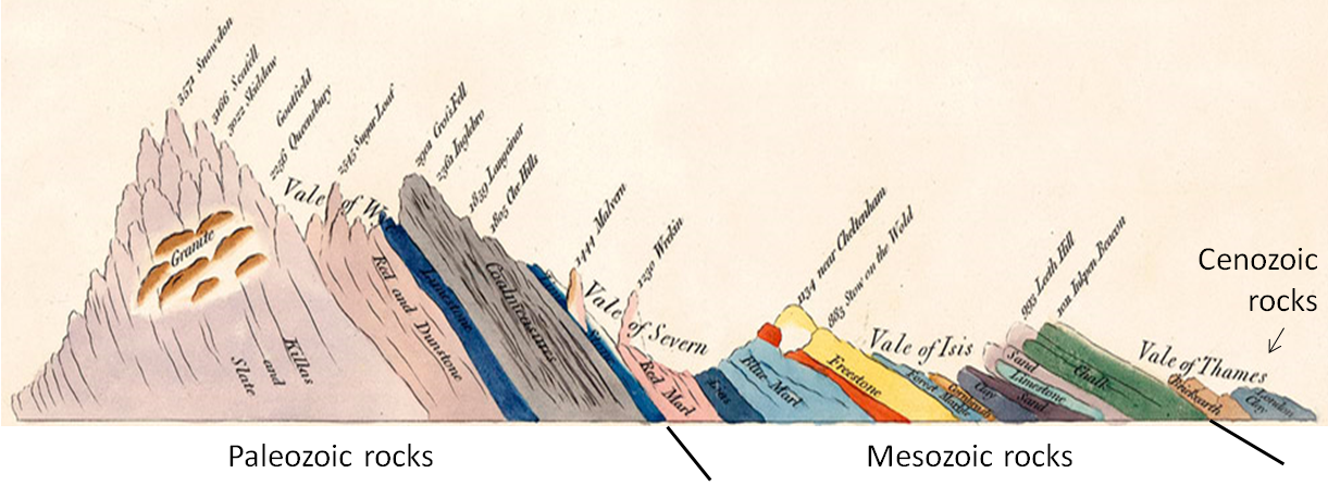
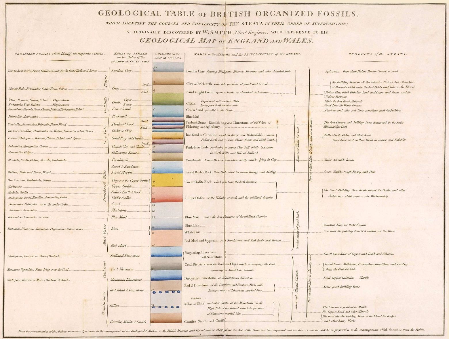
World history has seen the breakup of multiple supercontinents, such as Pangaea, Gondwana and Rodinia. I disagree with that history. I believe there was only the one supercontinent that broke up into the continents we see today, there was one great tectonic splitting of the continents and that was that. And one piece of evidence I have for that is that the standard interpretation has Pangaea breaking up somewhere around the Jurassic period IIRC, but William Smith's cross section of England shows all the time periods from Precambrian through Recent as having been laid down and then tilted together as a block which would certainly not have happened so completely and neatly if the continents split in the Jurassic period. Why do you think deposition wouldn't continue unbroken during the breakup of Pangaea? This assumption seems unjustified.
I conclude that the split occurred after all the strata/time periods were laid down. You conclude this based on flawed reasoning and Smith's rough diagram:
Smith characterized strata according to the material he was able to find. In the absence of mines he was forced to rely on material he found at the surface. The strata underlying London is not clay - that's just a surface deposit. There are strata labeled Sand and Blue Marl and Red Marl, all unconsolidated sediments, and they are just the materials Smith found at the surface - he couldn't dig down and see what the strata were actually made up of. The tilting (which is exaggerated in Smith's diagram) occurred during the Alpine Orogeny of around 50 million years ago.
And it was that tectonic action that caused all the major erosion and deformation, including the tilting of the rock layers in Smith's cross section, and most of the volcanism as well. Not that there hasn't been plenty of all three since then of course. But not before. Tectonic activity doesn't cause erosion except in the sense that it can move strata in ways leaving it vulnerable to erosion. For a simple example, uplift could change a region from one of net deposition to one of net erosion.
And again I remind you it's the Time Scale that I have primarily in mind, that happens to be attached to all the difrerent sedimentary columns around the world, making the sediments themselves unimportant. This is a very strange thing to say because it is the opposite of what is true. The geologic timescale is an amalgamation of information from all the stratigraphic columns from around the world. It is the facts about the strata themselves that is important.
As I say above, Smith's cross section proves the Jurassic breakup of the continents is wrong because the strata would not have been laid down to the present in England in that case. Again, why do you think the breakup of Pangaea would have brought deposition to a halt?
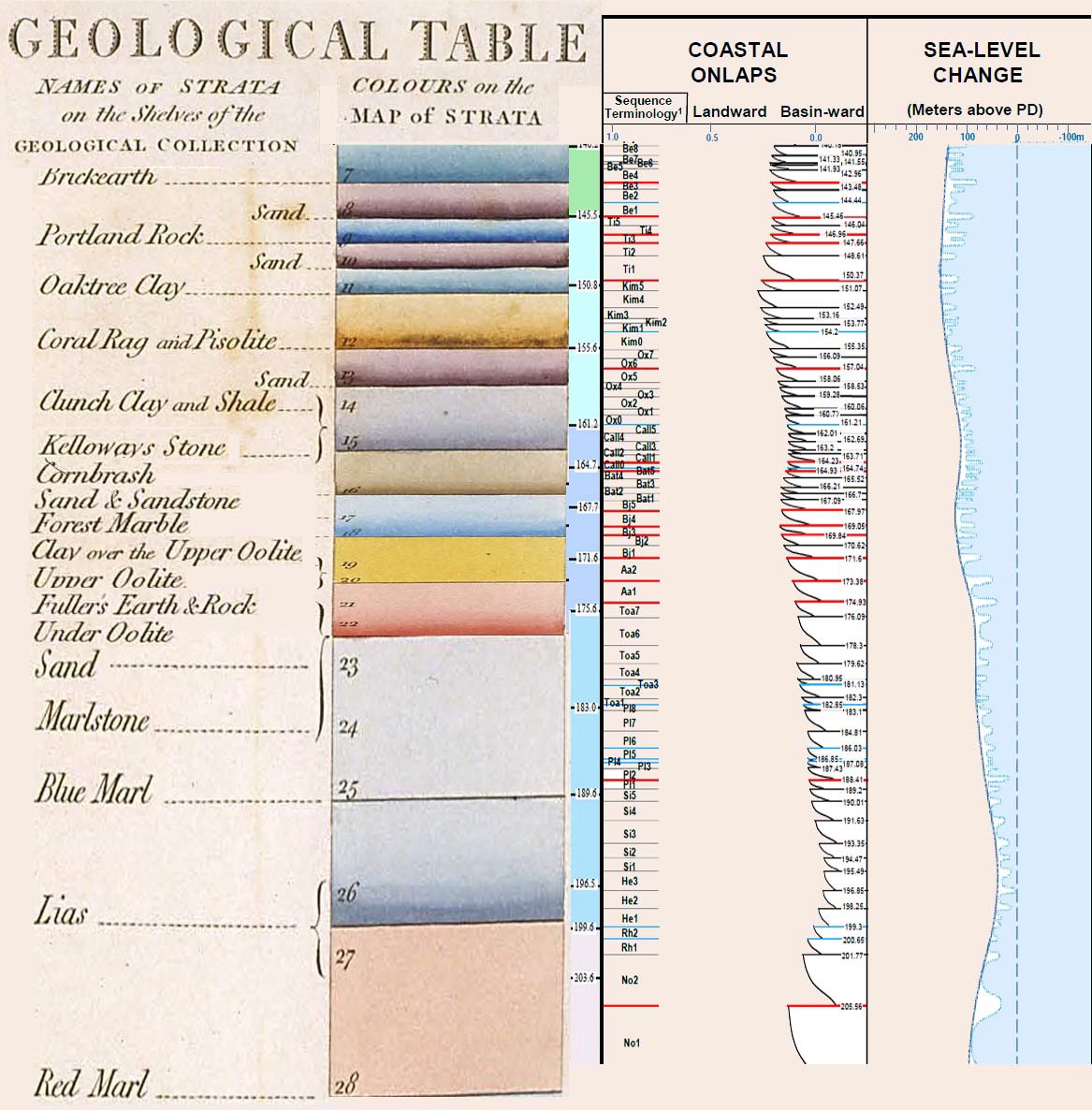
I can't read your chart, sorry. My eyes are much worse and it is a severe strain to be writing this at all. Of course you can't read my chart. Your chart of Smith you can read, mine you can't. Here they both are, yours on the left. I can barely make out the writing myself, so I have a hard time believing you can see anything in either chart. You're just referencing the chart and making stuff up:
Here's another Smith chart, go to town:
Why are you claiming now that you've described evidence when in other very recent posts from the past few days you've conceded that you have no evidence while hoping it will be found soon. You've obviously misread something and I have no way of finding out what. I quoted you saying this in Message 284 in the very message you're replying to, where you refer to your lack of evidence, and also repeat your mistake about the existence of complete stratigraphic columns:
Faith in Message 284 writes: Yes I know you explain this differently and my evidence is lacking because of the incomplete columns in spite of the complete ones. You've made a number of similar statements recently about your lack of evidence. Oftentimes you don't seem to know what evidence is, other times you just throw out some random evidence completely unrelated to your argument. --Percy
|
|||||||||||||||||||||||||||||||||
|
edge Member (Idle past 1727 days)  Posts: 4696 From: Colorado, USA Joined: |
The concept of rocks "swelling up" is something to contemplate, but I imagine it's just a poetic way of saying they got pushed up, but it's the "due to underground folding" ...
Actually, these are not Dickinson's words. They do not occur in quotation marks in the article and are not recognized geological terms. The only logical conclusion is that they are descriptive terms written by a journalist for a lay audience.
|
|||||||||||||||||||||||||||||||||
|
Faith Suspended Member (Idle past 1465 days) Posts: 35298 From: Nevada, USA Joined: |
The only logical conclusion is that they are descriptive terms written by a journalist for a lay audience. OK. io what about the "due to underground folding."
|
|||||||||||||||||||||||||||||||||
|
edge Member (Idle past 1727 days) Posts: 4696 From: Colorado, USA Joined:
|
The notion that the 'geological column' is 'over and done with' is as sillly as they come. One of the things we learn from events like the eruption of Kilauea is that geological processes that have gone on for at least the last half billion years continue today. Sedimentation driven by tectonism, erosion and deposition continue as before. Mountains rise, water erodes and sediments are carried to the sea.
|
|||||||||||||||||||||||||||||||||
|
|
Do Nothing Button
Copyright 2001-2023 by EvC Forum, All Rights Reserved
![]() ™ Version 4.2
™ Version 4.2
Innovative software from Qwixotic © 2024


 (1)
(1)