|

Understanding through Discussion |
|
|
Register | Sign In |
|
QuickSearch
| Thread ▼ Details |
|
Suspended Member (Idle past 1466 days)  Posts: 35298 From: Nevada, USA Joined: |
|
Thread Info
|
|
|
| Author | Topic: Motley Flood Thread (formerly Historical Science Mystification of Public) | ||||||||||||||||||||||||||||||
|
Percy Member  Posts: 22480 From: New Hampshire Joined: Member Rating: 4.8 |
Faith writes: ..has the disadvantage of repeating things a million times that have long since been answered though you won't discover that for days.
I think your errors deserve to be corrected as often as you make them. My "errors" in this case consist of (1) my calling something a "mountain" that looks like a mountain and is identified at Google Image as a mountain; and (2) my neglecting to say that the sheet of water had to become streams in order to form a meander,... You're selling yourself short. Your mistakes, misunderstandings and miscomprehensions are legion. You just replied to an 820 word message with a 101 word message. Here are the key points you ignored:
This morning I was 50 messages behind. Now late in the afternoon I am 72 messages behind. You could help me catch up by taking the time to reply to what is posted to you. --Percy
|
||||||||||||||||||||||||||||||
|
JonF Member (Idle past 190 days) Posts: 6174 Joined: |
I provided the context. It was Edge saying that erosion ultimately causes flat plains. Which you denied.
|
||||||||||||||||||||||||||||||
|
Percy Member Posts: 22480 From: New Hampshire Joined: Member Rating: 4.8 |
Faith writes: Perhaps it's you who misjudge the Word of God as an "ancient myth." If it ever hits you what it really is you may find yourself riveted to the floor in amazement as I did when I first discovered that God is real and no myth. Can I still believe in God if I don't believe in buried strata tilting, rock evaporating, sea floors rising and dropping, continents dancing jigs, floods sorting sediments, corpses and radiometric isotopes, and all the rest? --Percy
|
||||||||||||||||||||||||||||||
|
Percy Member Posts: 22480 From: New Hampshire Joined: Member Rating: 4.8 |
Faith writes: You are being purposely vague it seems to me. You talk about a "1910" something or other without bothering to be clear what you mean and I have no reason to think you know anything worth tracking down. I told you I can't see any fold in the Smith diagram. If you want me to see it you have to do something to make it possible. See Message 396. Took 15 seconds to find. You do know the discussion board has a search facility, right? I agree with you about including images in posts. I've been trying to encourage people to include any images under discussion in every message. There's almost no overhead involved. --Percy
|
||||||||||||||||||||||||||||||
|
Percy Member Posts: 22480 From: New Hampshire Joined: Member Rating: 4.8 |
Faith writes: I looked at all your links, which was a lot to ask of me since I had to move them to a Word document and zoom them to be able to see them,... When in your browser window just hit Ctrl-+ and the page will increment in size. Hit Ctrl-+ as many times as needed to grow the page (and it's attendant images) as large as you need. You may need to pan around to get the image in the field of view. When done simply hit Ctrl-0 and the page will return to normal size. Edge didn't respond, so I'll attempt an answer:
Also keep looking at the diagram. While the pictures show something more irregular than most of the examples I've seen they are still nowhere near the irregularity of the Kaibab curve and I'm still unable to see it as a meander. Itg just looks like a river that is running through an area of tributaries and something like small side canyons, nothing like the meanders in your pictures or the diagram, except the overall curve. But the terrain could cause the curve; meanders form where the land is flat. The diagram looks like any diagram of meanders and I'm not sure what I'm supposed to get out of it. It doesn't suggest anything like the Kaibab curve to me. Here's a satellite view of the Grand Canyon from Google Maps. There are straight parts and meandering parts:
You'll probably want to click on "View larger map". --Percy
|
||||||||||||||||||||||||||||||
|
Percy Member Posts: 22480 From: New Hampshire Joined: Member Rating: 4.8 |
edge writes: If you look up the term 'lystric faulting', you will get a good explanation. Interesting - I didn't know this was possible:
--Percy
|
||||||||||||||||||||||||||||||
Faith  Suspended Member (Idle past 1466 days) Posts: 35298 From: Nevada, USA Joined: |
I provided the context. It was Edge saying that erosion ultimately causes flat plains. Which you denied. I don't remember. Fine, I'm sorry if I misread you. Please forgive.
|
||||||||||||||||||||||||||||||
|
JonF Member (Idle past 190 days) Posts: 6174 Joined: |
OK.
|
||||||||||||||||||||||||||||||
|
Faith Suspended Member (Idle past 1466 days) Posts: 35298 From: Nevada, USA Joined: |
Smith diagram for reference:
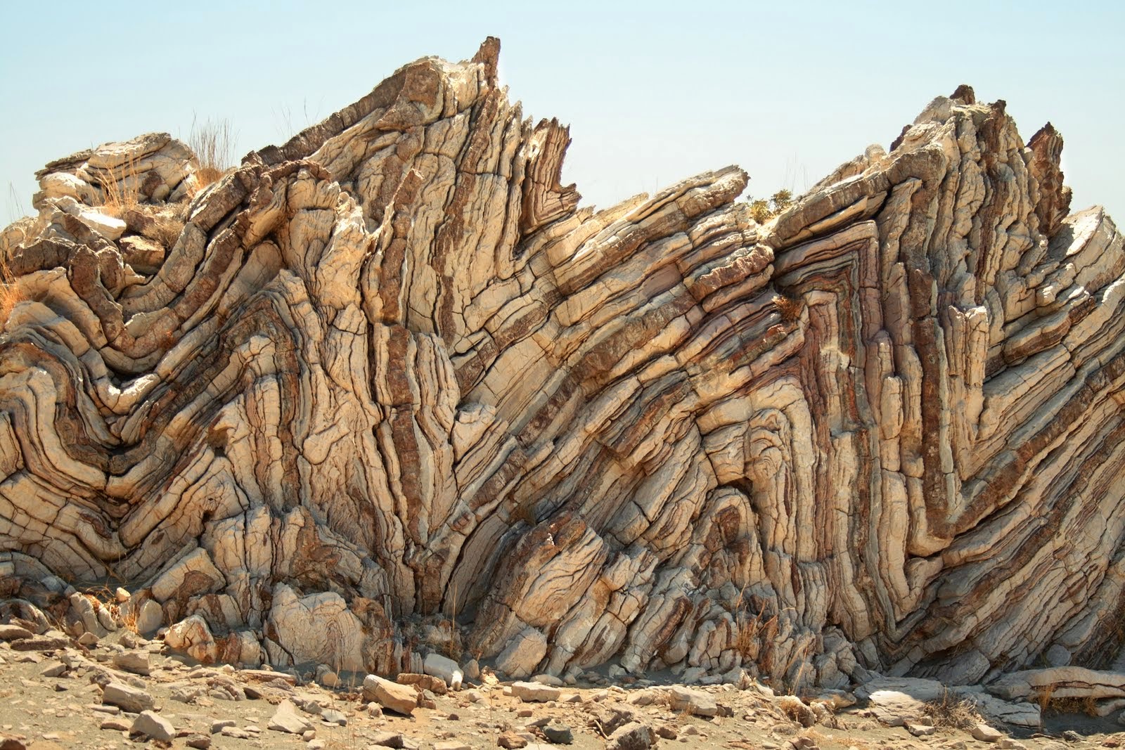
The principle of cross-cutting relationships is simple. You can’t cut something that isn’t there. Around the centre of the map (beneath and to the left of the Jurassic label) you will see that the lowest strata curve up - and stop. They have been cut by an erosional surface. The rocks immediately above do not follow the upward curve at all - they were clearly deposited on an irregular surface, but filled it in rather than following it. Likewise, beneath the Cretaceous label, there are strata curving upwards, along the side of the buried peak, and strata above them that do not follow that upwards curve at all. Again they seem to be deposited on an irregular surface, and some of them pinch out before reaching the buried peak. Thank you for giving a clearer description so I can at least get the gist of it. Icouldn't see the print (I see it now; sometimes I can see and sometimes I can't with borderline images, something to do with visual fatigue I think) so didn't know what edge was talking about referring to "old red sandstone" and the like. I copied your post and the diagram into a Word document and blew it up to print it out in landscape format, made it as big as I could in that format which isn't really big enough for my eyesight problems, used a magnifier to try to follow your remarks and think I got the main idea though there are still some words on the diagram I can't see. Don't know what the "peak" is you are talking about, or I think I may but find it hard to believe you'd call that a peak. HOWEVER, here's the problem. You are trying to convince me that you can tell what the original horizontal strata looked like from this area of extremely deformed strata underground, and I don't see it It's most likely that the deformation itself accounts for what you are imputing to the original deposition. "Cut by an erosional surface??" Not even sure what that means but in any case it describes the deformed strata with no reason to think it applies to the original deposited strata. "..cearly deposited on an irregular surface, but filled it in rather than following it." The "irregular surface" is the product of the deformation, no reason to impute it to the original horizontal deposition. And it's interesting you say the deposited layer filled in the irregularity rather than following it because somebody, you I think, was insistting that the strata followed the Kaibab rise of the Paleozoic strata in the Grand Canyon. And you say some of them "pinch out" etc., which has to be another consequence of the deformation rather than the original horizontal laying out. Here are a couple of the pictures of deformed strata that I posted back in Message 419 where I could point out places the layers "pinch out" or stop altogether, or thicken as if filling in an irregularity perhaps. Are you going to tell me all these things in these deformed blocks of strata are evidence of how they were originally laid down rather than the consequence of the deformation?
So it still looks to me like the strata were all laid down in the usual horizontal fashion and were then deformed as an entire block from the Cambrian to the Recent. It's really not fair even to try to prove your point with an extremely deformed stratigraphic column anyway. If you can't prove it with straight flat strata then you can't prove it at all. Edited by Faith, : No reason given. Edited by Faith, : No reason given.
|
||||||||||||||||||||||||||||||
|
edge Member (Idle past 1728 days)  Posts: 4696 From: Colorado, USA Joined: |
HOWEVER, here's the problem. You are trying to convince me that you can tell what the original horizontal strata looked like from this area of extremely deformed strata underground, ...
I thought you had determined that all strata were laid down horizontal, flat and continuous. So, now you are uncertain?
... and I don't see it It's most likely that the deformation itself accounts for what you are imputing to the original deposition.
Of course deformation has changed them from horizonatal, flat and continuous. That's why we call it 'deformation'.
"Cut by an erosional surface??" Not even sure what that means but in any case it describes the deformed strata with no reason to think it applies to the original deposited strata.
Are you just being obtuse here? If you had a stack of pancakes and eroded it away with your fork the layers would be interrupted, would they not?
"...clearly deposited on an irregular surface, but filled it in rather than following it." The "irregular surface" is the product of the deformation, no reason to impute it to the original horizontal deposition.
Red herring. It doesn't matter how the irregular surface formed. The erosional surface still cuts the stratigraphy of the older rocks.
And it's interesting you say the deposited layer filled in the irregularity rather than following it because somebody, you I think, was insistting that the strata followed the Kaibab rise of the Paleozoic strata in the Grand Canyon.
Sure, if the layering is horizontal and the surface it is deposited on is not, then you have an unconformity. You are just throwing things against the wall to see if anything sticks. And failing to do anything but obfuscate.
And you say some of them "pinch out" etc., which has to be another consequence of the deformation rather than the original horizontal laying out.
No. It means that there were topographic irregularities resulting in what we call an on-lap feature. It's like the Grand Canyon where the Tapeats pinches out against the Shinumo Quartzite monadnocks.
Here are a couple of the pictures of deformed strata that I posted back in Message 419 where I could point out places the layers "pinch out" or stop altogether, or thicken as if filling in an irregularity perhaps. Are you going to tell me all these things in these deformed blocks of strata are evidence of how they were originally laid down rather than the consequence of the deformation?
This is a misapplication of the term 'pinch-out'. Certainly not what Paul was talking about. Nevertheless, it is also irrelevant to your point. There is more deformation in the lower layers of rocks in each case. How did that happen if they were all deformed together "as a block"?
So it still looks to me like the strata were all laid down in the usual horizontal fashion and were then deformed as an entire block from the Cambrian to the Recent. It's really not fair even to try to prove your point with an extremely deformed stratigraphic column anyway. If you can't prove it with straight flat strata then you can't prove it at all.
Whut?? So, it's not fair to talk about deformed rocks when you are discussing deformation? Edited by edge, : No reason given.
|
||||||||||||||||||||||||||||||
|
Faith Suspended Member (Idle past 1466 days) Posts: 35298 From: Nevada, USA Joined: |
??? The miscommunication is now beyond hopeless. I don't think you said one thing that relates to anything I said. I don't know where to begin.
Edited by Faith, : No reason given.
|
||||||||||||||||||||||||||||||
|
PaulK Member Posts: 17825 Joined: Member Rating: 2.2 |
quote: Actually no. I am arguing that we can tell that the deformed strata have been eroded after deformation. And we can do that by seeing that the strata have been cut off - they terminate where they meet the stratum above, which has not suffered the same deformation.
quote: No. To start with the last point I mentioned that it was not impossible for later strata to follow the uplift - not that they had actually done so. I don’t remember anyone insisting otherwise, ever. However, the fact that the upper and lower surfaces are not parallel (while the strata when shown are) does indicate in this case that the irregularities were filled in rather than being the result of later deformation.
quote: I don’t see anything like that, while the diagram is really clear:
Your images again:
In the second one it looks very much as if the fold occurred before the unfolded rock above it was deposited.
quote: No it doesn’t.
quote: Your usual baseless whining is noticed. First, if we are going to show evidence of deformation occurring before all the strata were deposited we have to show deformed strata. Second, places where the deformation is cut off are extremely good evidence of erosion occurring before all the strata were deposited. Third, you brought up this cross section by using the misleading Smith diagram and a correction was needed. Fourth, part of that correction is showing that the more accurate diagram includes evidence against your claims. Whining that people dare to show that you are wrong - as you frequently do - is hardly sensible.
|
||||||||||||||||||||||||||||||
|
Faith Suspended Member (Idle past 1466 days) Posts: 35298 From: Nevada, USA Joined: |
Actually no. I am arguing that we can tell that the deformed strata have been eroded after deformation. And we can do that by seeing that the strata have been cut off - they terminate where they meet the stratum above, which has not suffered the same deformation. De3formation on top of deformation?: What would that prove? ABE: I can make abolustley no sense of your reasoning about strata being "cut off." Edited by Faith, : No reason given.
|
||||||||||||||||||||||||||||||
|
PaulK Member Posts: 17825 Joined: Member Rating: 2.2 |
quote: It’s a LACK of deformation on top of deformation. The upper layers do not show the same deformation. (They may show some but not the same) That the strata are cut off is an observation. They rise until they meet the upper strata and then stop. From this we conclude that the deformed lower layers were truncated by erosion and then the upper layers were deposited on top.
|
||||||||||||||||||||||||||||||
|
Faith Suspended Member (Idle past 1466 days) Posts: 35298 From: Nevada, USA Joined: |
ABE: Sorry, I keep editing this because I can't make sense of it and keep having different thoughts about it. I'm back to thinking that although you denied it you are describing the original laying down of the strata, lower strata being eroded before upper strata deposited, but you are making this case from the whole deformed stack, which is what makes no sense. As I said, I think what we see in the deformed stack happened after all the deformation had occurred. There's really no reason to think otherwise. /ABE
From this we conclude that the deformed lower layers were truncated by erosion and then the upper layers were deposited on top. I keep trying to make sense of this and just can't. I get the idea, I get that you think the lower deformed strata look like they were cut off by erosion and since the strata above them are relatively undeformed by comparison they must have been laid down after the lower were eroded. But this is happening to a whole area of already-deformed strata which has nothing to do with the original laying down of the layers. Sorry, makes no sense. Edited by Faith, : No reason given. Edited by Faith, : No reason given. Edited by Faith, : No reason given. Edited by Faith, : No reason given. Edited by Faith, : No reason given. Edited by Faith, : No reason given. Edited by Faith, : No reason given. Edited by Faith, : No reason given.
|
||||||||||||||||||||||||||||||
|
|
Do Nothing Button
Copyright 2001-2023 by EvC Forum, All Rights Reserved
![]() ™ Version 4.2
™ Version 4.2
Innovative software from Qwixotic © 2024