|

Understanding through Discussion |
|
|
Register | Sign In |
|
QuickSearch
| Thread ▼ Details |
|
Thread Info
|
|
|
| Author | Topic: Geology- working up from basic principles. | |||||||||||||||||||||||||
|
The Matt Member (Idle past 5560 days) Posts: 99 From: U.K. Joined: |
I've read a fair few discussions on geology, and whether what we see is the result of eons of slow deposition or a rapid global flood a few thousand years ago, and I've also seen the various arguements used to undermine conventional geology and promote flood geology.
Many discussions seem to get nowhere, often based on misunderstandings or ignorance of how geology works and how geologists come to te conclusions that they do. They also seem to focus on single examples, for example a polystrate fossil or an alleged footprint. To combat this, I'd like to have a discussion which starts out with some of geology's basic principles, and once these have been satisfactorally dealt with, we will work up to discussing how certain rocks can form and what they can tell us about their environment, and then on to how we can read sequences of rocks to gain an understanding of change in conditions through time and space. The first thing I would like to deal with is the law of superposition. This states that sedimentary layers form in a time progressive sequence with the oldest layers at the bottom and the youngest on the top. To view this simply, picture stacking books one on top of the other- the book you put down first will by at the bottom of the pile, and the book you put down last will be at the top. Can we agree this principle is sound?
|
|||||||||||||||||||||||||
|
The Matt Member (Idle past 5560 days) Posts: 99 From: U.K. Joined: |
Thanks for promoting this
 Unfortunately I know barely anything about the Grand Canyon, so I found I couldn't really make much of a contribution to that thread, although it does make a great read.
|
|||||||||||||||||||||||||
|
The Matt Member (Idle past 5560 days) Posts: 99 From: U.K. Joined: |
No objections yet then. Good. some more principles:
The principle of Cross cutting relationshipsIf a feature such as an igneous intrusion (rock formed by magma cooling below ground) or a fault cuts through layers of rock, it must be younger than the rock it cuts. The principle of inclusions and componentsIf a rock has parts of another incorporated into it, the incorporated parts must be older than the rock. For example if a layer of sandstone contains pebbles or boulders, they must be older than the layer they are contained in. This can also be seen in igneous intrusions, where they contain pieces of the rock that surrounds them (that are often thermally altered). These pieces are called xenoliths. Questions?
|
|||||||||||||||||||||||||
|
The Matt Member (Idle past 5560 days) Posts: 99 From: U.K. Joined: |
Next, the principle of original horizontality.
Originally it was believed that all strata was deposited in horizontal layers and if they appear tilted, it is because they have been disturbed by tectonic movements. Think of this as more of a guideline. Most strata seems to be formed more or less horizontally, however material in some circumstances can be laid down at an angle of up to 30 degrees. The point to take away here is that strata seen with an extreme tilt or folded into anticlines and/or synclines must have been tilted after deposition and lithification (turning to rock). More on how we tell how rock is tilted later when I deal with way-up structures.
|
|||||||||||||||||||||||||
|
The Matt Member (Idle past 5560 days) Posts: 99 From: U.K. Joined: |
Good question. There are a number of things we could look at to determine whether we are looking at a fold or a current ripple:
Firstly we could look at the geometry of the features. While the ones pictured may bear a superficial resemblance to current ripples, many do not, for example these and these. Many of the tilts we observe greatly exceed the angle of repose for the substance in question. The angle of repose refers to the maximum slope angle that can be achived before friction is overcome and the slope fails. For dry sand, this is approximately 30 degrees from horizontal, and this is a high figure for unconsolidated sediment. From this we can know that if we see a sedimentary layer at an angle of say 60 degrees, it cannot have been laid down at that angle in flowing water. Secondly, we could look at the rocks involved. Lavas could be incorporated in to such features, as can evapourites, both of which cannot be formed by quickly moving moving water. Rocks could also show evidence of exposure to air at the surface, such as mud cracks or fossil rootlets or give us clues about which way up they were during their deposition (I will deal with these in more detail soon). Thirdly, we need to understand how ripples form. Various different types of ripples can form depending on the exact conditions present, however those caused by a flow (as opposed to an oscillation, with no net flow) are all characterised by erosion of material from one side, and deposition on the other, so the internal structure of the ripple differs substantially from the wavy form we see at the surface. See the lower diagram here. Symmetrical ripples (upper diagram) as you can see are characterised by layers deposited on either side that are not continuous and overlap in the middle. If we saw this kind of internal structure within a feature, we may consider it current deposited, but otherwise it seems unlikely.We also need to know what kind of conditions can produce huge ripples. We have observed them in places where massive floods have occured, such as the channeled scablands of the US. These floods were very rapid and highly erosive, with very high water speeds, and as such would not allow the deposition of sands or fine clays which can take hours/days to completely settle out even in still water. The presence of such fine material in a large fold would rule out being formed by currents.
|
|||||||||||||||||||||||||
|
The Matt Member (Idle past 5560 days) Posts: 99 From: U.K. Joined: |
That's quite an accusation. The principles I've dealt with so far are the very basics of geology, so it is natural that we would both start with them. Currently I'm writing almost entirely from my own knowledge, although I consulted Knighton's 'fluvial processes and landforms' breifly to jog my memory on ripple formation. I assure you if I lift any material from a website or book it will be duely cited.
{Note: See here and upthread for the apology and discussion of the issue. End of discussion here. - Adminnemooseus} Edited by Adminnemooseus, : See above. Edited by Adminnemooseus, : Fixed link in previous edit. I had linked to the wrong topic.
|
|||||||||||||||||||||||||
|
The Matt Member (Idle past 5560 days) Posts: 99 From: U.K. Joined: |
Thanks for the vote of confidence bluegenes
Moving on: I've stated so far that rocks are laid down oldest at the bottom and youngest at the top, but I've also mentioned that folds are able to disturb strata and tilt them subsequent to deposition. A good question to ask here would be "how would we know if layers have been overturned entirely?" One method I have already mentioned- this is the principle of inclusions and components. If a sedimentary layer contains eroded fragments of another, the layer must post date it. If we see a layer containing eroded bits of the one above it we know they have been overturned. There are also a number of other features, collectively referred to as way-up structures. These include: Mud /desiccation cracks.When wet mud dries it often produces a cracked pattern on its surface with small fissures penetrating down in to it, as shown here. These can become filled with another sediment, often sand, and be preserved, as seen here showing us that at the time of deposition the cracks must have been pointing down. Any kind of fissure would do the trick, such as neptunian dykes (a blanket term which seems to encompass any kind of fissure infilled with sediment that formed in a marine environment) Link (subscription required unfortunately). Likewise Ice wedge and sand wedge casts (periglacial, i.e. permafrost features) could be used Link (roughly one third of the way down the page) Geopetal structuresThese form when an organism with an internal cavity becomes partially infilled with mud soon after death, leaving the surface of this mud roughly horizontal. The rest of the cavity is usually mineralised when the sediment is lithified (turned to stone). This does more than tell us up from down- it actually acts as a crude spirit level, and measuring them can give us an approximate angle at which the sediment was deposited. See here Tool/groove marksThese are a small erosional features formed by flowing water on the surface of the sediment. They form where stones, shells, or indeed anything dragged by water leave small furrows and/or dents where they are dragged or bounced along the soft sediment. See here (roughly half way down). Fossils & trace fossilsFossils such as rootlets can tell us down from up as naturally roots must have grown into the ground. Trace fossils (features left by an organism, but not actually being part of it) can be used too, such as footprints or burrow traces. Ripples are a possibility too, as Bdfoster already mentioned. This list could go on and on but I think I have covered enough for now. The link I provided earlier seems to be the best online resource for sedimentary structures I’ve found, but even this isn’t 100% comprehensive. Anything unclear so far?
|
|||||||||||||||||||||||||
|
The Matt Member (Idle past 5560 days) Posts: 99 From: U.K. Joined: |
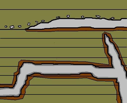
I've also mentioned that igneous material (formed from molten rock) can be intrusive or extrusive. Intrusive means that it cooled and turned to rock within the ground, and extrusive means that it set on the surface. So if we see igneous material among sediments, how would we tell if it is intrusive or extrusive? This will be important for radiometric dating purposes among other things.
Take a look at this diagram:
Igneous intrusions that are 'concordant', i.e. are squeezed between layers are known as sills, and are harder to tell apart from lavas, but we can do this by looking for: -Continuity. Sills can often jump between layers as shown in the lower left.-Baked margins. Hot lava/magma thermally alters material surrounding it. On lava flows it will only alter the lower surface as there was nothing above it to alter when it was cooling. Intrusive bodies however will have altered rock both above and below. These are the dark brown sections. -Chilled margins. These are more tricky, but generally only occur in intrusive bodies with finer crystals towards the edge where cooling occurs faster. These are represented by the dark grey. Link -Eroded fragments. If we find eroded fragments of an igneous layer in the layer above, it must have been exposed at the surface. It should be determined that we are not looking at a major unconformity before we take this as evidence, as erosion could expose a sill and then fragment it. If we apply these to the diagram we can easily see that the lower rocks are intrusive and the upper is extrusive. Again, there are more methods than this but I've covered enough for now.
|
|||||||||||||||||||||||||
|
The Matt Member (Idle past 5560 days) Posts: 99 From: U.K. Joined: |
Sure. Intrusive means it solidified underground in cavities full of magma*. Extrusive means formed at the surface as old lava* flows or volcanic ash deposits which have erupted on to the surface from volcanic vents.
*Magma is the term used to describe molten rock that has not yet erupted, and lava is that which has. As for the diagram- I have indicated baked margins with the darker brown colour. The igneous rock at the top has not altered the rock above it because it was not there at the time the lava was erupted- it formed on the surface. Likewise the processes that could produce the weathered fragments on the upper igneous rock only occur at the surface.
|
|||||||||||||||||||||||||
|
The Matt Member (Idle past 5560 days) Posts: 99 From: U.K. Joined: |
One more principle then:
Lateral continuity quote:source Therefore it is not unreasonable to assume that if we see similar strata on opposite sides of a valley, they were once continuous and formed contemporaneously. We may also deduce that if we see a sudden truncation in strata then we are probably looking at a fault. Corellating strata over large distances is more tricky. If we cannot do this by superposition or by following the strata in boreholes then we could do this by biostratigraphy which I shall discuss shortly.
|
|||||||||||||||||||||||||
|
The Matt Member (Idle past 5560 days) Posts: 99 From: U.K. Joined: |
Right you are. There are exceptions to this. Would you agree that this is a fair generalisation though, particularly for marine environments? Obviously we are not to take this principle to be a gospel truth.
Working with the example of a small river valley you use- even if we cannot correlate individual beds well, if we saw river terraces of equal height and composition on either side of the valley it would be a fairly good guess that these were once continuous in that they were part of the same floodplain, do you think?
|
|||||||||||||||||||||||||
|
The Matt Member (Idle past 5560 days) Posts: 99 From: U.K. Joined: |
Great link, Thanks.
Sorry for the long silence here- I've not had a stable internet connection for a while, but all is sorted now. Next: The Principle of Faunal Succession(see Vashgun/Minnie's link) Fossils are not randomly distributed throughout the rocks of the earth, but rather occur very well sorted in well observed predictable zones. We do not find trilobites after the Paleozoic and we do not find any mammals or birds until the Mezosoic for example. Link. Furthermore species within these broad groups occur in a very well observed and predictable order. A common misconception here is that the principle uses an assumption of evolution, which isn't true. It was developed in the late 1700s prior to Darwin's birth. Biostratigraphy is a technique used to make detailed correlations between rocks in different areas using detailed faunal succession. Using the principle of superposition, geologists work out what order the fossils occur in and how extensive/limited their range (for biostratigraphy those with a short time range and large geographic range are most useful). The next step is to try to find the fossils in an area of rocks of similar age. In many cases we can find the same fossils in the same order in rocks separated by huge distances, for example many carboniferous zone fossils used in England can be found to some degree in Eastern Europe, Russia, Asia and the US*. Here is a pretty good page on biostratigraphy. *No web reference I'm afraid. From:Ramsbottom (1977) Major cycles of transgression and regression (mesothems) in the Namurian. Proceedings of the Yorkshire Geological Society, Vol 41, pp. 261-291 Edited by Adminnemooseus, : Changed subtitle from "Re: Good page from another topic - Relative Dating Lab page" to "The Principle of Faunal Succession".
|
|||||||||||||||||||||||||
|
The Matt Member (Idle past 5560 days) Posts: 99 From: U.K. Joined: |
I'm not sure I entirely understand your objection here, but I hope that this makes things clearer.
Superposition deals purely with how sedimentary rocks (and to some extent igneous rocks, but only those deposited at the surface) are laid down initially. Nothing more. Layers can be moved subsequently, but this is outside the scope of superposition. This is not to say that it is unacknowledged, as we do recognise that sequences can be subsequently moved and we find ways to tell if things have been. A couple of examples: We know that folds can overturn sequences so the oldest is at the top and the youngest at the bottom. In post 15 of this thread I described the 'way-up structures' we can use to see if this has happened. Layers, particularly igneous ones, can be squeezed in between layers of rock later on. Post 16 describes how we would confirm that these layers are younger than those surrounding them. Does this help?
|
|||||||||||||||||||||||||
|
The Matt Member (Idle past 5560 days) Posts: 99 From: U.K. Joined: |
I'd be happy to put some of this on the website, but for the moment I'd like to let this thread progress and then I'll make it into something that reads a bit more coherently when some more stuff has been covered.
|
|||||||||||||||||||||||||
|
The Matt Member (Idle past 5560 days) Posts: 99 From: U.K. Joined: |
Why is superposition not consistent with YEC? Superposition would still apply if every sedimentary rock in the world was deposited by a global flood. The rock at the bottom would be from the early flood as the waters rose and those at the top would be the very last deposits as the waters drained away.
|
|||||||||||||||||||||||||
|
|
Do Nothing Button
Copyright 2001-2023 by EvC Forum, All Rights Reserved
![]() ™ Version 4.2
™ Version 4.2
Innovative software from Qwixotic © 2024