|

Understanding through Discussion |
|
|
Register | Sign In |
|
QuickSearch
| Thread ▼ Details |
|
Thread Info
|
|
|
| Author | Topic: Great debate: radiocarbon dating, Mindspawn and Coyote/RAZD | |||||||||||||||||||||||||||||||||||||||
|
mindspawn Member (Idle past 2682 days)  Posts: 1015 Joined: |
I'm proposing a Great Debate between Mindspawn and Coyote on the subject of radiocarbon dating. I contend that radiocarbon dating is reasonably accurate (10% or better), and as such has disproved the young earth claim, as well as the claim of a global flood at about 4,350 years ago. Evidence should be limited to accepted science, and not include numerous rabbit-holes which lead nowhere. "What-ifs" with no evidence supporting them should not be permitted. This thread should be in the Science Forum. If this thread is promoted, and Mindspawn agrees to participate, I will let Mindspawn have the first post Thanks for the thread. My main problem with carbon dating is its calibration against tree ring chronology, which I feel is unreliable due to assumptions about the annual nature of rings. Tree growth is normally relative to moisture, and moisture cycles are not always annual: http://web.utk.edu/~grissino/principles.htm"As used in dendrochronology, this principle states that rates of plant processes are constrained by the primary environmental variable(s) that is most limiting. For example, precipitation is often the most limiting factor to plant growth in arid and semiarid areas. In these regions, tree growth cannot proceed faster than that allowed by the amount of precipitation, causing the width of the rings (i.e., the volume of wood produced) to be a function of precipitation. In some locations (for example, in higher latitudes and elevations), temperature is often the most limiting factor. For many forest trees, especially those growing in temperate and/or closed canopy conditions, climatic factors may not be most limiting. Instead, processes related to stand dynamics (especially competition for nutrients and light) may be most limiting to tree growth. In addition, the factor that is most limiting is often acted upon by other non-climatic factors. While precipitation may be limiting in semiarid regions, the effects of the low precipitation amounts may be compounded by well-drained (e.g. sandy) soils." We see in the above quote that variation in precipitation is often the main cause of variation in tree growth. In areas with only rare rainfall and well drained soils, there is no reason to assume the rings would be annual. The rings in arid areas are precipitation sensitive, and this is compounded by well drained soils. So if a region receives sporadic rainfall, and this water completely drains out the soil until the next rainfall, this would cause rings that are not annual, but are sensitive to every significant rainfall. The growth occurs while the soil is wet, and stops when the soil drains out:"While precipitation may be limiting in semiarid regions, the effects of the low precipitation amounts may be compounded by well-drained (e.g. sandy) soils"
|
|||||||||||||||||||||||||||||||||||||||
|
mindspawn Member (Idle past 2682 days) Posts: 1015 Joined: |
If that is the case, this will be a short thread, because this objection is easily dealt with! Let's forget all about the tree ring chronology (even though as the Peanut Gallery post shows, your objection is unfounded). Coyote I haven't got time to read up in the peanut gallery, and I wont be referring there often at all. This is a one on one debate, if you feel there are good points made there, could you kindly make those points here in this forum. At this stage you have given no argument to my point about tree rings.
We can go with the the glacial varve chronology, or the coral chronology instead. Or use spelothems This too is no argument, could you kindly post links and I will look into each argument presented.
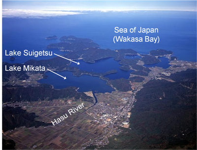
During the past 10,000 or so years the uncalibrated ages are off by about 10% at the most extreme. The error gets a little larger up around 30,000 years ago. This shows quite clearly on the calibration curve. The calibration curve has been posted here many times, but I'll post it again: The calibration curve you have presented is merely circular reasoning. Sure all of them present the same dates, but they use carbon dating to find the dates. You cannot use carbon dates to prove carbon dates, that is circular reasoning. The consensus could easily be rainfall related and out by approximately a factor of twelve until the uncertainties of the 40 000 to 80 000 ya period, but I will have to look into it when you give me the background detail for the other studies. Lake Suigetsu is doubtful as discussed in the other thread, as follows: 1) Lake Suigetsu is so low lying and so near the coast that very high tides could cause mass Diatom die-offs creating diatom layers that are more frequent than annual. This is not fairytale what-ifs but a highly probable scenario given the lake's proximity to the sea. Diatoms form layers on the surface of the lake, as the salt water table rises this would kill off the lower freshwater diatoms. Someone speculated that the salt water would not rise high enough to kill off the lowest diatoms however this was mere speculation. No figures were actually presented (depth of lake/depth of diatom layer/depth of saltwater). 2) Lake Suigetsu is fed by the Hasu river. This is a small river with a small catchment area. Sediment flows into Lake Suigetsu would be affected by every large rainfall and not necessarily be perfectly seasonal. http://naturalishistoria.files.wordpress.com/...etsu-map.pngPlease see how close the lake is to the ocean, to believe the saltwater table would not effect freshwater diatoms in Lake Suigetsu is very naive:
Edited by mindspawn, : correcting the factor
|
|||||||||||||||||||||||||||||||||||||||
|
mindspawn Member (Idle past 2682 days) Posts: 1015 Joined: |
You missed the point entirely! We are not talking about the calibration curve any longer. You objected to it, in fact it was your main objection to radiocarbon dating, so we'll just leave it out of the discussion entirely--forget all about it! We will go with uncalibrated radiocarbon ages! They are not quite as accurate, but close enough. The young earth belief is still falsified. Your main objection to radiocarbon dating, that is, tree-rings, is out the window, gone, and radiocarbon dating still produces ages far in excess of what it would take to falsify your beliefs. I didn't miss the point at all. My mention of tree rings was because you still stated "Let's forget all about the tree ring chronology (even though as the Peanut Gallery post shows, your objection is unfounded)." So you still brought up tree rings. All you used to make your point is one graph with a few labels on it.I challenged the Suigetsu dates on that graph, if you give me more information, I will challenge all the other dates on that graph. for example the Bahamas Speleothem data is also assumed to be annual, but speleothems are formed through running water. In a cave where running water is consistent and fed by a large water table, obviously the speleothem growth will reflect seasonal/annual changes in average water flows. However in a coastal region not fed by a large water table, growth patterns in speleothems would obviously relate to each torrential rainfall followed by a dry spell. Four forms of radiocarbon consensus are all highly rainfall sensitive:1) Tree rings from the arid White Mountain region 2) Lake varves from Lake Suigetsu (small catchment area) 3) Bahamas speleothems 4) Lake Lisan was in a dry region that is also precipitation sensitive, not necessarily sensitive to entire seasons. http://www.tau.ac.il/...ublications/Lisan-levels-Machlus.pdf The low stand of Lake Lisan during most of this period indicates relative dry climatic conditions in the region. Its entirely possible that the consensus in radiocarbon dating is obtained merely through misunderstanding rainfall sensitive data as representing annual/seasonal data.
|
|||||||||||||||||||||||||||||||||||||||
|
mindspawn Member (Idle past 2682 days) Posts: 1015 Joined: |
You just don't understand radiocarbon dating enough to get the point I'm making. This is becoming frustrating! What you are arguing is the various methods to establish a calibration curve may be flawed. What I am saying is we can discard the idea of calibration entirely and just use the uncalibrated ("conventional") ages. This is where radiocarbon dating was in the 1950s, before it was realized that the effects of atmospheric fluctuation should be accounted for. So we are no longer talking about tree-rings, varves, corals, or any of those other methods of establishing a calibration curve. We are talking about "conventional" radiocarbon ages. These are the measured age as corrected for isotopic fractionation. No calibration is done at all. These conventional ages still show that the young-earth belief is incorrect. You are correct, I don't understand what you are talking about. I am not focusing on the calibration curve, my arguments have been clearly focused on the dates at those 7 locations. 4 locations are precipitation sensitive more than seasonally sensitive, 3 of those locations use uranium-thorium dating. The only evidence that you have posted for your position has been a graph showing firstly radiocarbon dates of material at 7 locations on earth and secondly actual observations of annual layers at 4 locations that confirm the radiocarbon dates by counting the layers to get actual dates. The last 3 locations are dated according to uranium-thorium to determine their age. On the surface of it your argument appears sound, but as you delve into each location, the assumption of annual layers appears doubtful because the layers at 4 of those 7 locations would more likely reflect strong precipitation than actual seasonal layers. ie the layers are formed from each and every significant rainfall, and are not formed annually. This means that on the graph the carbon dates should be re-calibrated according to number of significant precipitations per year, and the actual dates should also be adjusted to reflect these multiple layers per year (of varves/tree rings/ice layers). Hopefully you can understand my position and how it refutes your position, and yet also explains the consilience between the methods, this consilience due to various regions having approximately the same number of significant rainfalls in a year. Edited by mindspawn, : No reason given. Edited by mindspawn, : No reason given.
|
|||||||||||||||||||||||||||||||||||||||
|
mindspawn Member (Idle past 2682 days) Posts: 1015 Joined: |
Regarding the last 3 of the 7 locations referred to on your graph, it appears the Carico Basin and Papua New Guinea dates are established through comparing Uranium-Thorium dating with Radiocarbon dating. I am still looking into how they originally calibrated Uranium-Thorium dating , if they calibrated this according to carbon dating, this ruins the claimed consilience, and in the following link it appears this is what they actually do. They seem to assume radiocarbon dates are accurate , and then apply uranium-thorium methods to these dated coral samples. In this way they can establish a calibration curve for uranium-thorium dating which they can use for periods earlier than carbon dating can function. If radiocarbon dating gives out incorrect dates, this would mean so would uranium-thorium dating, their corroboration is meaningless if uranium-throrium dating is calibrated using radiocarbon dating.
http://s3.amazonaws.com/...s/30652880/Fairbanks_etal2005.pdf Regarding the PS2644 (voecher et al) data, this is established from layers of ice. Once again these layers are more precipitation sensitive than seasonally sensitive (a layer forms when there is a large snowfall/rainfall) Have you got any further evidence for the accuracy of radiocarbon dating? Edited by mindspawn, : No reason given.
|
|||||||||||||||||||||||||||||||||||||||
|
mindspawn Member (Idle past 2682 days) Posts: 1015 Joined: |
You just don't understand radiocarbon dating enough to get the point I'm making. This is becoming frustrating! What you are arguing is the various methods to establish a calibration curve may be flawed. What I am saying is we can discard the idea of calibration entirely and just use the uncalibrated ("conventional") ages. This is where radiocarbon dating was in the 1950s, before it was realized that the effects of atmospheric fluctuation should be accounted for. So we are no longer talking about tree-rings, varves, corals, or any of those other methods of establishing a calibration curve. We are talking about "conventional" radiocarbon ages. These are the measured age as corrected for isotopic fractionation. No calibration is done at all. These conventional ages still show that the young-earth belief is incorrect. I've been thinking about what you have been saying, and realize where the misunderstanding could have come in. I think your graph distracted me because that is the only supporting evidence that you have posted and your graph was referring to various forms of corroboration, and comparing these to calibrated radiocarbon dates (dates that had been adjusted for variation of the magnetic field and calibrated according to other forms of dating). To ignore calibration is naive, because this would assume that the amount of carbon produced during periods of strong magnetic field is the same as today's carbon production, when all parties know this is not true. The way to correct for this is to use various known dates of objects during periods of increased magnetic strength, and then re-calibrate the reduced carbon levels of the past according to the known dates. The period during which there was increased magnetic field strength was earlier than 1800 years ago. This is where tree ring data , varve data, ice core data can help to establish the correct carbon ratio for each of these ages during periods of reduced atmospheric carbon production due to the strong magnetic field in the past. I am saying that true ages of these trees/varves/ice cores are over-estimated by possibly a factor of 11 or 12 and the calibration curve is therefore exponentially affected when projecting these incorrectly calibrated dates onto the uncalibrated period of 12 000 - 80 000 years bp.
|
|||||||||||||||||||||||||||||||||||||||
|
mindspawn Member (Idle past 2682 days) Posts: 1015 Joined: |
So, do you have any objections to the radiocarbon method other than tree-rings and varves, etc., which are entirely incidental to the method itself? Thanks for explaining in more detail. I do understand your point better now. My main objection to the radiocarbon method is what I believe to be the underestimation of the effect of the magnetic field from 1800bp and earlier. With a large increase in magnetic field strength, a small effect of 10% to radiocarbon dates is unrealistic. The magnetic field causes "significant variations to carbon-14 production rates" Carbon-14 - Wikipedia"Production rates vary because of changes to the cosmic ray flux incident, such as supernovae, and due to variations in the Earth's magnetic field. The latter can create significant variations in carbon-14 production rates, although the changes of the carbon cycle can make these effects difficult to tease out" "The natural atmospheric yield of carbon-14 has been estimated to be about 22 000 atoms 14C per meter square of the surface of the earth per second, resulting in the global production rate of about 1 PBq/a.[11] Another estimate of the average production rate[12] gives a value of 20 500 atoms m−2s−1. Occasional spikes are possible; for example, there is evidence for an unusual 10-fold increase of the production rate in AD 774—775.[13]" A ten-fold increase was recorded in AD 774-775. Spikes are possible. The strength of the magnetic field causes significant variation. It appears that the conventional carbon dates require significant calibration to be an accurate reflection of true dates. The accuracy of carbon dating is entirely dependent on calibration with known dates.
|
|||||||||||||||||||||||||||||||||||||||
|
mindspawn Member (Idle past 2682 days) Posts: 1015 Joined: |
In order to calibrate the conventional radiocarbon age, items with known dates were tested. This resulted in the calibration curve that I posted earlier, and the lengthy discussion that RAZD has provided in the Peanut Gallery thread. Your objection that "The accuracy of carbon dating is entirely dependent on calibration with known dates" is taken care of. I dealt with 7 of these "known dates". Your challenge is to show how the small catchment area leading into varves of Lake Suigetsu would not be rainfall dependent , and would be seasonal. I did mention tides before but I am currently focussed on precipitation causing regular sedimentation and varves in the lake. Additionally please prove that layers from ice cores are not precipitation dependent, but are seasonal. Additionally please prove that tree rings in arid conditions (bristlecone pines) are not rainfall dependent but are formed seasonally/annually. The nature of each of these locations specifically favors layers caused by precipitation events rather than entire years/seasons. Its possible the nature of the locations have been overlooked because of the perceived consilience of these locations with existing radiocarbon dates. Additionally please provide any other objects of known date which have been used to calibrate carbon dating so we can discuss the potential inaccuracy of those dates as well.
And your objection that cosmic rays/magnetic field can cause radiocarbon dates to vary wildly is unfounded. That is what the calibration curve does--it permits correction of the conventional radiocarbon ages for the effects of cosmic rays and the changing magnetic field. In other words, the variations in C14 levels in the atmosphere are accounted for! There goes your objection. The wikipedia article made the claim that the magnetic field causes "significant variations to carbon-14 production rates". I never claimed that the magnetic field causes dates to "vary wildly". I believe a strong magnetic field over a long period of time, will cause a significant reduction of carbon over that period of time. The exact extent can be determined through checking carbon levels against correctly dated objects. My problem is that the objects they are choosing to calibrate carbon levels have highly doubtful dates. If you can prove certainty of your dates, then my objection is dealt with, until then the calibration curve is based on dodgy dates and my objection remains valid.
Unless you have some evidence to support your religiously-based belief that calibrated radiocarbon dates are not adequately corrected by the calibration curve, this discussion would seem to have come to a conclusion? I'm awaiting your evidence that the varves/ice cores/tree rings can only be interpreted as annual layers.
This resulted in the calibration curve that I posted earlier, and the lengthy discussion that RAZD has provided in the Peanut Gallery thread. My discussion is with you only, you are welcome to re-post anything you feel is significant from the peanut gallery into this thread. Edited by mindspawn, : No reason given.
|
|||||||||||||||||||||||||||||||||||||||
|
mindspawn Member (Idle past 2682 days) Posts: 1015 Joined: |
This is just absolute nonsense. You expect us to believe that all of the different elements that go into the calibration curve are all wrong, for a variety of different reasons, in the exact same manner? Tree-rings in California and Europe, lake and glacial varves in a variety of locations, spelothems, and corals are all wrong but still give the same answers! If you want to get serious let me know. Otherwise, your just wasting our time. Its not a variety of reasons, 4 of those locations are precipitation sensitive. That's one reason. The half-life of Uranium-Thorium is not independently established in a laboratory, but measured against existing dating methods and so is bound to evolutionary assumptions and this explains the consilience in the other 3 locations. Uranium-Thorium dating even calibrates against radiocarbon dating and so these dates become meaningless as independent verifiction of radiocarbon dates. Weather occurs in cycles and patterns, eg cold fronts. It logical that there would be approximately the same number of major precipitation events every year, and so the consilience is not unrealistic. Of all the locations in the world which have definite seasonal patterns, scientists have specifically found 4 locations that are precipitation sensitive rather than seasonal sensitive to find their consilience. Just this puts the whole consilience under doubt, due to the nature of the locations used contradicting the annual requirement of the layers:1) White Mountain bristlecone pines are precipitation sensitive and the location has very dry soil. I challenge you to explain to me how the wood continues to grow between rainfalls in an area of dry soils. 2) Lake Suigetsu is fed by a river in a small catchment area. I challenge you to explain to me how layers of sediment wash into a lake in seasonal patterns without a high degree of sensitivity to each significant rainfall 3) Ice cores are precipitation sensitive, each large snowfall/rainfall would by its very nature create a layer, please explain why those layers are annual and not sensitive to each major precipitation during the year. 4) Lake Lisan was also in a dry area, please explain why each rainfall in a semi-desert region does not form a layer of sediment. In wet regions sediment flows in rivers and lakes show seasonal patterns, due to saturated water tables allowing continuity of the flow between rainfalls. This seasonal effect is lessened in dry areas which are more sensitive to each and every rainfall. Unfortunately for you those locations definitely favor 11-12 layers a year consistent with precipitation, rather than one layer a year. You need a stronger argument than consilience to counter my argument of precipitation sensitivity of those locations, which explains the consilience due to consistent worldwide rainfall patterns.
|
|||||||||||||||||||||||||||||||||||||||
|
mindspawn Member (Idle past 2682 days) Posts: 1015 Joined: |
I disagree about the rabbit holes and what-ifs.......
But I have no objection to RAZD substituting for you. I see some good points have been made in the peanut gallery, however if I start responding to them here this defeats the objective of a one-on-one discussion, and I only have time for a one-on-one. I am sure RAZD will be bringing some of those points into this discussion which will add spice to this debate.
|
|||||||||||||||||||||||||||||||||||||||
|
mindspawn Member (Idle past 2682 days) Posts: 1015 Joined: |
Curiously I read the paper and found absolutely nothing about 14C dating, calibration of 14C, tree ring counting or lake varve counting. The only thing you remark on -- dry climatic conditions -- applies to the dead sea area, an area geologically separate from any of the 14C vs annual layer systems. You have presented zero evidence that it is related to climate in any other location and that it affects 14D dating in any way. That's a Red Herring Logical Fallacy. quote:Reconstruction of paleo-shorelines of Lake Lisan, the late Pleistocene precursor of the Dead Sea, is based on sequence stratigraphy of fan-delta and lacustrine deposits that are exposed at the Perazim Valley, southwest of the Dead Sea. The shoreline sediments are physically correlated with lacustrine aragonites, their ages are determined by U-series dating, to establish a lake-level curve for the time interval between 55 and 35 kyr. ... ... A correlation between the Lake Lisan sedimentary record and deep sea and ice core records reveals that during warm (interglacial) episodes in the North Atlantic, the Dead Sea-Jordan region was dry, and the level of Lake Lisan dropped (Stein, 1999; Schramm et al., 2000). ... The study basically investigates how alluvial fans at river mouths show the lake level history, it is completely irrelevant to 14C dating and to the formation of varves in the center of a lake. Perhaps you should read Introduction To Geology to better understand how irrelevant this is. Thank you RAZD for your well researched posts. I have had the time to start looking into replies to your first two posts, and before I replied you have since added some more. This possibly means that you have more time than me, in which case to even the playing field I would like you to post one post for every one of mine, to keep the number of discussion topics limited for now. I hope this is ok for you, I think it would make it easier for everyone and ourselves to follow the discussion. You may not have realized, but most of my discussion has revolved around the seven points of consilience in Coyote's graph in message 4:Tree Ring Lake Suigetsu Bahamas Speleothem Carioca Basin PS2644 Lake Lisan Papua New Guinea Lake Lisan is clearly listed as one of the points of consilience related to radiocarbon dating, and this is why I brought up Lake Lisan to look into how those layers were formed. My focus remains on those 7 points of consilience which is when you joined the conversation and therefore Lake Lisan remains relevant. The only point I was making from the link is that Lake Lisan was in a dry region, I'm not sure why you were trying to find other relevance in my link when I was clear on what was relevant.
I have shown that dendrochronology is both precise and accurate to it's current (data) limit of 12,405 years of age, with 100% accuracy and precision for the "year without a summer" in 1816 (197 years ago) and 99.5% accuracy and precision at over 8,000 years ago. I have shown that the tree rings are annual formations with high accuracy and precision. Thus I have answered to your "main problem" and this should be the end of this thread. Don't you think to summarize and conclude you have won the debate is a little early if you take into account I haven't even replied to your posts? Also to post a picture of a plummeting plane is a little premature in my eyes. Also to assume my link on Lake Nisan was irrelevant is one point, but to post about a Red Herring Logical Fallacy is going a little far considering you were wrong about the irrelevance.
Confirmation Bias, Cognitive Dissonance and ide fixes, are not the tools of an open-mind or an honest skeptic, and continued belief in the face of contradictory evidence is delusion. The objective empirical evidence shows consistently, consiliently, that the earth is old, very very old ... over 4.5 billion years old, and my advice is ... get used to it. This discussion is in its infancy, please do not mistake my busy lifestyle and slow replies for avoidance. I am looking forward to your open mind during the rest of our discussion, hoping you will have a mature approach to the rest of the discussion. Edited by mindspawn, : No reason given.
|
|||||||||||||||||||||||||||||||||||||||
|
mindspawn Member (Idle past 2682 days) Posts: 1015 Joined: |
I thought I would deal with one of the more egregious claims you have made, just to get it out of the way first: When I said four of those locations are precipitation sensitive I was not referring to Ireland or Germany. I was referring to Lake Lisan, White Mountains of California, Lake Suigetsu and Cariaco Basin. I thought that the Cariaco Basin was ice core related, but since then I see it relates to sediments washing into the gulf of Mexico, which is also precipitation related during past times.
Note that we have 4 places in Northern Ireland where the rainfall occurs with a similar but slightly different total rainfall per month in each place. Thus the rainfall pattern in Ireland alone is not precisely the same in all locations -- a requirement for your claim of consistent rainfall patterns causing rings instead of annual rings. I agree that the whole world does not have exactly the same rainfall patterns, but this wasn't the actual requirement of my claim. Maybe you missed the essence of my claim, possibly I am at fault through not communicating clearly. Due to weather having patterns from major weather phenomenon like cold fronts, cyclones etc, there is a regular cyclical nature to weather in most locations. Various locations on earth can have an annual weather pattern of approximately 10-12 major wet spells interspersed with dry spells and minor wet spells. I wasn't meaning to imply that the whole world has exactly the same weather in exactly the same patterns. 3 weather stations close to locations under discussion are as follows: White Mountains:Bishop Climate, Weather By Month, Average Temperature (California, United States) - Weather Spark Mammoth Lakes Climate, Weather By Month, Average Temperature (California, United States) - Weather Spark Jordan River:Amman Climate, Weather By Month, Average Temperature (Jordan) - Weather Spark Cariaco Basin:Maiqueta Climate, Weather By Month, Average Temperature (Venezuela) - Weather Spark Monthly rainfall charts are irrelevant to this discussion as they do not reveal significant dry and wet spells, we need daily rainfall charts for that.
White Mountains quote: Located in east central California just north of Death Valley, and on the western edge of the Great Basin, the White Mountains rise to a respectable altitude of 14,246 feet (4342m). Yet they remain in a rain shadow map of the Sierra Nevada located a few miles west across the deep Owens Valley. As Pacific storms move eastward, the Sierra simply takes the majority of moisture, leaving the White Mountains with strong dry winds. Annual precipitation is less than 12 inches (30cm), most of which arrives as snow in winter. On a summer's day the amount of precipital moisture in the air is about half a millimeter, the lowest ever recorded anywhere on earth. . Your quote simply supports my position. The soils are so dry, that its impossible for the trees to grow during the dry spell. Every rain spell therefore shows as a ring, because the growing stops between the rain spells. Yes the spring melt would cause a ring, but these trees are also temperature sensitive, and so rainfalls during the warmer months would also cause small rings. Between the spring melt and summer rainfalls the tree cannot grow, as the soil completely dries out. The summer rainfalls are most suitable for growth (warmth and water) and so rings would form then.
Thus it may be valid to claim that growth of the Bristlecone Pine is water limited, however it should be noted that most of the 12" of rain arrives as snow, and thus this water is not available for tree growth until it melts in the spring. As an evergreen (unlike the Oaks which are deciduous) these trees would tend to grow year-round, with the larger cell size growth in the spring, thus making annual rings that are easily discernable. You believe just one tree ring was formed annually in spring? If this is what you believe I find that highly unrealistic. Contrary to your claims, the rainfall figures over the last year also do show significant rainfalls above an inch in summer in the area. These trees are temperature sensitive, and with a complete drying out of soil in a dry spell after spring, there is no reason to doubt growth during a warmer period of summer rainfall. To create chronologies further back than living trees (dated to 4800 bp) you need dead trees that have remained in good condition for thousands of years. How did these dead trees survive without rotting for so long? In addition creationists have actually shown that young bristlecone pines can show multiple rings per year, this study was done by Lammerts.
In all three chronologies the year without a summer was correctly identified as occurring in 1816, a precise and accurate assessment Please present your evidence for this comment in all 3 chronologies. I'm especially interested in your proof of this in specifically those most ancient of living bristlecone pines in the arid white mountain area. Many bristlecone pines are found in warmer wetter areas, of course these would show annual rings, but this would not prove your point about the more ancient bristlecone pines.
In addition, the three dendrochronologies agree with over 99.5% precision for over 8,000 years of record (see Age Correlations thread for details). Conclusion The Irish and German Oak dendrochronologies are not based on rainfall patterns as claimed, but on annual growth patterns. The Bristlecone Pine dendrochronology is based on annual precipitation from snow melting in the spring. I wont be referring to entire whole threads for your evidence, if you wish to make a point kindly post your point in this thread, or give me a link to an exact post in another thread regarding this 8000 year agreement. Up to this point I haven't discussed the Irish and German Oak chronologies. Neither of these are in dry regions therefore I agree with you about annual rings currently. However I believe these regions were in dryer environments in the past. The Holocene had dry patches which would have affected tree growth rings by a large factor (the number of annual wet/dry spells per year). This would be reflected in much smaller rings during dry periods.http://www.clim-past.net/8/1751/2012/cp-8-1751-2012.pdf Edited by mindspawn, : No reason given. Edited by mindspawn, : No reason given.
|
|||||||||||||||||||||||||||||||||||||||
|
mindspawn Member (Idle past 2682 days) Posts: 1015 Joined: |
"Uranium-Thorium" is a dating method, not an element with a half life. Uranium is one element, Thorium is another. Both Uranium and Thorium have a number of isotopes. Isotopes are a family of types of the same element with the same number of protons in the nucleus but different numbers of neutrons. Each isotope will have a different half-life, except for stable isotopes which do not decay and therefore do not have a half-life. The Uranium referred to is 234U with a half-life of 245,000 years. The Thorium referred to is 230Th with a half life of 75,000 years. The half-lives of both 234U and 230Th have been measured in the laboratory. All this is true, I should have worded my point more carefully. There are various ways to establish the half-lives of isotopes, possibly the most accurate would be to test the ratio of parent/daughter of the same sample, in a mass spectrometer over a precise time period (eg 10 years). Another method would be to use instruments to test the number of decay events, and to establish a rate of decay from that. However in actually determining the half lives of thorium and uranium the following link gives no hint that either method was used. Instead the actual ratios of parent/daughter and their subsequent half-lies were determined using samples of rocks dated using other methods.http://radiocarbon.ldeo.columbia.edu/...5Fairbanks+table.pdf "we measured 234U/238U and 230TH/238U atomic ratios in 4 different materials that were likely to have behaved as closed systems for 10`6 years." Unless you can show me otherwise it appears the most accurate calibration of uranium/thorium dating is calibrated using uranium-uranium dated samples (234U/238U). Ratios were determined in a laboratory using mass spectrometry, but actual decay events were not measured in a laboratory. This could open up a can of worms because you now have to prove the accuracy of radiometric dating to verify your carbon dates.
The age is calculated by a purely mathematical formula where the variables are: the half-life of uranium-234, the half-life of thorium 230 the amount of uranium-234 in the sample and the amount of thorium-230 in the sample The formula will always return exactly the same age for the same inputs, and thus the accuracy and precision of the dated relies on the accuracy and precision of the measurements. The important point here is to determine how accurately and how independently they measured the half-lives of thorium 230 and uranium 234. You are welcome to post evidence that Ur-th dating was measured independently of other dating methods.
Conclusion The consilience of these two completely independent systems provides very high confidence in these results -- all the data is provided with over 99% precision and accuracy. I have yet to see any proof that Ur-Th decay rates were established independently of calibration with other dating methods. If they were calibrated against other dating methods then this in itself explains the consilience and makes your conclusion irrelevant.
|
|||||||||||||||||||||||||||||||||||||||
|
mindspawn Member (Idle past 2682 days) Posts: 1015 Joined: |
No, your participation is in its infancy. Both coyote and I have years of involvement with it. My participation spans over 8 years on this forum since I began the first Age Correlations thread, now in its fourth version with over 1236 posts ... with no evidence that the ages given are false. You provide me with objective empirical evidence rather than fantasy wishful hokum and you will see how open-minded I am. Try to snow me with BS and fantasy and you will find my skepticism of your argument difficult to beat. And if you want a mature discussion then you can stop insulting the thousands of scientist who put their life work into this field by presenting childish complaints and wishful fantasies that a little research on your part would show you their fallacy. I repeat: do you really think that all all these scientists (see reference list for a sampling) are such naive, blundering and incompetent bufoons that they have never considered the difference between annual and other effects? Further, if you want to have a mature discussion then you will provide objective empirical evidence to support your position and explain not just why any single system is wrong but why they are all wrong in the same manner, even when they depend on totally different mechanisms. Enjoy. I'm ignoring your whole post. Its too long and immature for good discussion. If you would like to re-post your most relevant points, you are welcome. I am making precise points, and if you are able to answer the actual points I make in a more succint manner I would appreciate the exchange.
|
|||||||||||||||||||||||||||||||||||||||
|
mindspawn Member (Idle past 2682 days) Posts: 1015 Joined: |
Measured in the lab. Note that the new half-lives agree within the margin of error with previously determined values and that the margins of error are reduced in the new determinations. The 234U half-life is about 3 longer than previous values and the 230Th half-life is about 4 longer, so they confirm previous lab measurements with a difference of only 0.3% (older) for 234U and 0.4% (older) for 230Th (the symbol is parts per thousand). Yes they did use the mass spectrometer in the lab, but that was used to determine the relative ratios of variously dated samples. How the samples were dated is a separate question, and the article seems to indicate the samples were dated using Uranium-Uranium dating, which already have "accepted" half -lives. It appears we have an absolute stalemate here until you present further evidence for your position. We will have to agree to disagree on how the latest half-lives of 230Th and 234U were established.
This is you not reading the article and following the references -- and then jumping to conclusions. You are confusing correlation with calibration. They measured the age of the coral by uranium/thorium dating AND by uranium-uranium to show that they got the same results, thus giving a highly consilient accurate and precise calendar age calculation for the coral samples. Your "read the article and all the references" approach does not cut it. It reminds me of your comment about cognitive dissonance and having an open mind. With all those references at your disposal I am hoping that you are able to find the part that supports your position that the half-lives used in Th-Ur dating are independently established. Edited by mindspawn, : No reason given.
|
|||||||||||||||||||||||||||||||||||||||
|
|
Do Nothing Button
Copyright 2001-2023 by EvC Forum, All Rights Reserved
![]() ™ Version 4.2
™ Version 4.2
Innovative software from Qwixotic © 2024