|

Understanding through Discussion |
|
|
Register | Sign In |
|
QuickSearch
Summations Only | Thread ▼ Details |
|
Thread Info
|
|
|
| Author | Topic: Why the Flood Never Happened | ||||||||||||||||||||||||||||||||||||||||||
|
JonF Member (Idle past 189 days) Posts: 6174 Joined: |
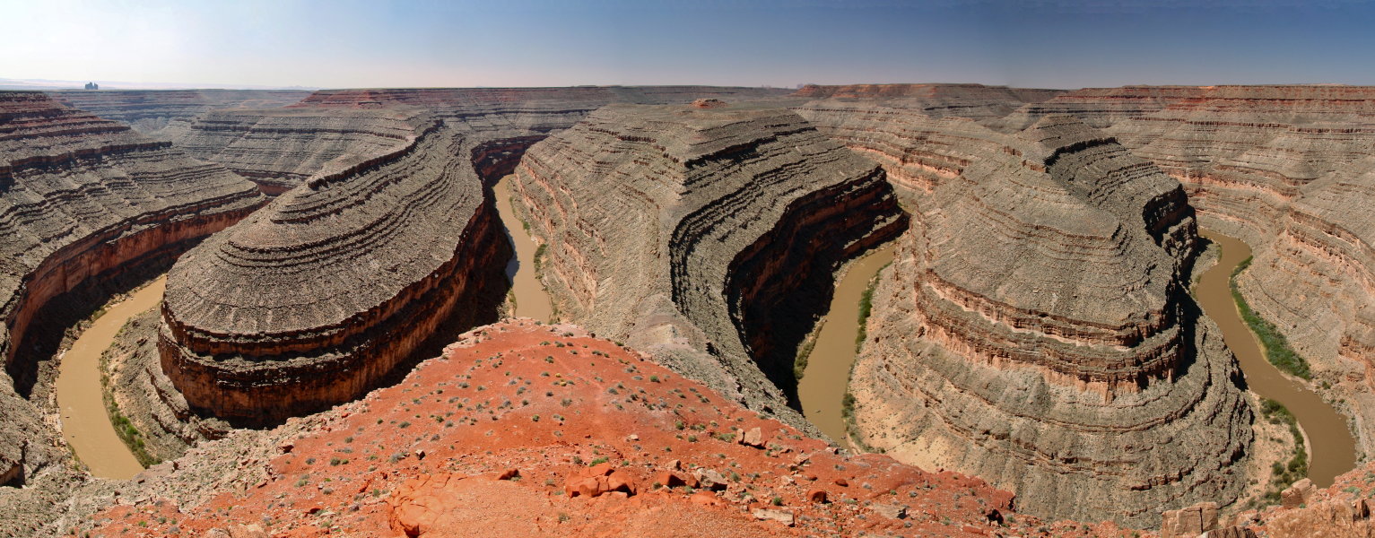
If this is the case, let me see if I have your scenario correct. The Flood came across the whole of the land and when the waters receded, the canyon was carved (albeit minus meanders, which would later be carved by the river). This left some water contained within the canyon, which began the process of carving meanders into the canyon. She's repudiated her original claims (without, of course, acknowledging it). Now she's claiming that the majority of the canyon and pretty much all the geology of the Southwest is caused by cracks from the uplift, which just happened to form the shape of widened meandering rivers, and the meanders are just minor add-ons. Since she's moved from just the GC to the entire Southwest, the Goosenecks of the San Juan are now relevant:
So, Faith, where how deep did the original crack go and how much of the current depth was carved by a slow-flowing river in hard rock?
|
||||||||||||||||||||||||||||||||||||||||||
Faith  Suspended Member (Idle past 1465 days)  Posts: 35298 From: Nevada, USA Joined: |
understand that you claim to not care about the meanders, but shouldn't your explanation be able to cope with all of the available evidence, including said meanders? OF COURSE NOT. WHO EXPECTS SOMEONE TO KNOW EVERYTHING WHO IS JUST TRYING TO ESTABLISH ONE POINT?
If this is the case, let me see if I have your scenario correct. The Flood came across the whole of the land and when the waters receded, the canyon was carved THE FLOOD BUILT UP THE STRATA IN THE SOUTHWEST TO SOMETHING LIKE THREE MILES DEEP. AT OR NEAR THE END OF THE FLOOD THE TECTONIC FORCES BEGAN, ASSOCATED WITH THE VOLCANIC ACTIVITY, ALL CAUSING THE EARTHQUAKES AND THE FAULTING, AND CAUSING THE UPLIFT AND THE CRACKING OF THE UPPERMOST STRATA WHICH ALLOWED THE WATER TO RUSH IN, BRINGING CHUNKS OF THE STRATA ABOVE THE KAIBAB WITH IT, WHICH IS WHAT CARVED OUT THE CANYON AND SCOURED OFF THE KAIBAB AT THE SAME TIME.
(albeit minus meanders, which would later be carved by the river). This left some water contained within the canyon, which began the process of carving meanders into the canyon. WHAT? AT SOME LEVEL THE WATER WAS MORE OF A RIVER THAN A DELUGE. RIVERS CUT MEANDERS.
Now, if I have your position correct, my question would still remain (from many messages ago), "Where are the original portions of the canyon that had to first contain the river prior to any meanders being carved by the Colorado?" If the river had changed course to carve meanders, which could not be carved by the quick removal of flood waters, then it must have originally been in a different location within the canyon. I DON'T KNOW WHERE TO BEGIN. THE RIVER IS WHAT WAS LEFT OVER FROM THE FLOOD WATERS WHEN THE FLOOD HAD PRETTY MUCH DRAINED THROUGH THE CANYON.
Then, the river changed course and began to carve out the meanders, but these mysterious sections of canyon that are required to exist with your model are not seen anywhere, especially where they should be seen, which is near each meander in the river. WHAT ARE YOU TALKING ABOUT? CHANGING COURSE? SEPARATE RIVER FROM FLOOD? WHAT KIND OF NONSENSE ARE YOU TALKING?
If your situation is correct and the flood carved out the canyon with the river carving the meanders, then near every meander should be a more ancient section of canyon with no river flowing through it anymore and simply a dry riverbed. This could show that the river did change course after the canyon was carved. As I see that multiple maps have been posted, could you kindly direct me to where in these maps you see these ancient dry riverbed canyons that do not follow the meanders, but rather the path that receding flood waters would have carved? Edited by Faith, : No reason given.
|
||||||||||||||||||||||||||||||||||||||||||
|
Faith Suspended Member (Idle past 1465 days) Posts: 35298 From: Nevada, USA Joined: |
The river did not widen the top of the canyon to its current extent. Wall collapse did that, as we see happening today. Not all rivers create meanders. Only slow flowing ones on reasonably flat ground. Rivers running in cracks don't create meanders. THE CRACKS WERE IN THE UPPERMOST STRATA THAT WASHED AWAY. THE CRACKS ALLOWED IN THE DELUGE, THE RIVER DIDN'T "RUN" IN THE CRACKS. EITHER THE CANYON WAS CARVED OUT TO A LEVEL THAT IT HAD A FLOOR FOR THE RIVER TO CREATE MEANDERS FROM OR THDE MEANDERS WERE CREATED BY THE RESISTANCE OF THE BUTTES AND STANDING WALLS THAT THE RIVER HAD TO FLOW AROUND.
Many of the meanders you have been shown form most to all of the depth of the canyon, and therefore were there at or very near the beginning. THE KEPTH OF THE CANYON IS ONLY TO THE KAIBAB. THE STRATA WERE BUILT TO AT LEAST A MILE ABOVE THAT, AND IT WAS THE TOP OF THOSE STRATA THAT WOULD HAVE BEEN CRACKED.
Cracked soft wet sediment does not support tall vertical walls as we see all over the canyon. \\ Rock does not form by drying out. In your latest scenario the top layers would still be unconsolidated. THEY HAD BEEN UNDER OVER A MILE OF STRATA, PLENTY OF WEIGHT AND PRESSURE. YES THE WALLS CAVED IN. WATER RUSHING IN WOULD CDERTAINLY HAVE FACILITATED THEIR CAVING IN.MY SCENARIO HAS NOT CHANGED. A MILE OR MORE OF STACKED SEDIMENT WAS WASHED AWAY ABOVE THE KAIBAB LEVEL DURING THE FORMING OF THE CANYON. THE CRACKING OCCURRED TO THE UPPERMOST LEVEL OF THAT UPPER STRATA.
No matter how big you make your letters, your latest fantasy is even more ridiculous than your original one. Do you even realize that you have totally changed your story I HAVE NOT CHANGED MY STORY. Edited by Faith, : No reason given. Edited by Faith, : No reason given.
|
||||||||||||||||||||||||||||||||||||||||||
|
JonF Member (Idle past 189 days) Posts: 6174 Joined:
|
THE CRACKS WERE IN THE UPPERMOST STRATA THAT WASHED AWAY YOU IDIOT. THE CRACKS ALLOWED IN THE DELUGE, THE RIVER DIDN'T "RUN" IN THE CRACKS. IDIOT. EITHER THE CANYON WAS CARVED OUT TO A LEVEL THAT IT HAD A FLOOR FOR THE RIVER TO CREATE MEANDERS FROM OR THDE MEANDERS WERE CREATED BY THE RESISTANCE OF THE BUTTES AND STANDING WALLS THAT THE RIVER HAD TO FLOW AROUND. All caps doesn't make your story any more realistic. So now you are saying that the river carved most of the canyon, in what you have referred to as "hardened rock". Not enough time.
THEY HAD BEEN UNDER OVER A MILE OF STRATA, PLENTY OF WEIGHT AND PRESSURE. IDIOT. Plenty of pressure but not enough heat and time. Nowhere near enough.
I HAVE NOT CHANGED MY STORY THAT IS AN EVIL LIE. It's not a lie, but looking back I see I was wrong. You have not been clear but you did have the same story a few weeks ago. I apologize.
|
||||||||||||||||||||||||||||||||||||||||||
|
Tempe 12ft Chicken Member (Idle past 357 days)  Posts: 438 From: Tempe, Az. Joined:
|
If the river was formed from the remaining water after the flood waters receded, then there was an original course to the river through the canyon (which you claim was carved by the flood). However, your claim for the meanders is that they were not carved by the flood, but by the river after the flood receded. This would mean that originally after the flood, we are left with a river with no meanders inside the canyon, correct? Somehow, the river has to adjust its course creating the meanders within the canyon, but shouldn't there be an original shape to the canyon without the meanders included, since they were not carved until after the flood waters receded? This would leave sections of canyons from where the river originally settled near the current meanders in the river/canyon. These sections would contain the ancient riverbed from the original course the Colorado River took post-flood.
Faith writes: WHAT KIND OF GARBAGE IS THAT?/ OF COURSE NOT YOU IDIOT. WHO EXPECTS SOMEONE TO KNOW EVERYTHING WHO IS JUST TRYING TO ESTABLISH ONE POINT? YOU PEOPLE ARE LIARS AND CHEATS AND IIDIOTS. No need for name calling, that is the behavior of a child and I will not reciprocate this emotional attack. Plus, you have no reason to call me an idiot as I was trying to be quite polite to you.
Faith writes: THE FLOOD BUILT UP THE STRATA IN THE SOUTHWEST TO SOMETHING LIKE THREE MILES DEEP. AT OR NEAR THE END OF THE FLOOD THE TECTONIC FORCES BEGAN, ASSOCATED WITH THE VOLCANIC ACTIVITY, ALL CAUSING THE EARTHQUAKES AND THE FAULTING, AND CAUSING THE UPLIFT AND THE CRACKING OF THE UPPERMOST STRATA WHICH ALLOWED THE WATER TO RUSH IN, BRINGING CHUNKS OF THE STRATA ABOVE THE KAIBAB WITH IT, WHICH IS WHAT CARVED OUT THE CANYON AND SCOURED OFF THE KAIBAB AT THE SAME TIME. Tectonic activity does not cause meanders to be carved, so it must have been caused by the river, correct? While I know you are incorrect in how the canyon was carved, I am simply pointing out one issue with your concept that the river carved the meanders after the flood carved the canyon.
Faith writes: WHAT? AT SOME LEVEL THE WATER WAS MORE OF A RIVER THAN A DELUGE. RIVERS CUT MEANDERS. WHAT IS YOUR PROBLEM?????????????????????? Slow moving rivers, on flat land cut meanders, not all rivers do so.
Faith writes: THIS IS SO STUPID I DON'T KNOW WHERE TO BEGIN. THE RIVER IS WHAT WAS LEFT OVER FROM THE FLOOD WATERS WHEN THE FLOOD HAD PRETTY MUCH DRAINED THROUGH THE CANYON. Which is what I said your statement was. But the flood receding couldn't carve the meanders, so the river must have done so after the flood in your model. Which means that the river originally settled in a canyon with no meanders and then carved the meanders afterwards. This would have left sections of the canyon with the old way the river went prior to the meanders being carved. These sections of ancient canyon should be located near each meander within the canyon. The fact that these ancient canyons are not present refutes your statement that the river carved the meanders after the canyon was formed. Rather, what we do see is that the canyon naturally follows the meanders of the river, which can be explained through uplift and a river with meanders cutting into the bedrock as the land around is pushed upwards.
Faith writes: WHAT ARE YOU TALKING ABOUT? THIS IS PURE IDIOTIC BLATHER. CHANGING COURSE? SEPARATE RIVER FROM FLOOD? WHAT KIND OF NONSENSE ARE YOU TALKING? The idiotic blather, as you so eloquently put it, is what your model requires for the river to carve the meanders into the canyon post-flood. The fact that even you call this idea idiotic (which your whole process requries) should show you that your concept of how the canyon was formed is based upon idiotic principles. Therefore, why should any of us give it any credence.
Faith writes: GET OFF THIS THREAD. YOU ARE AN IDIOT. If I am an idiot according to Faith, that must mean I am intelligent to most of the rest of the world, so I will take this as a compliment. Also, if you could grow up and at least attempt a civilized discussion, that would be most excellent. Also, I will not get off this thread as you are unable to answer my point that refutes your statement. How did the river carve meanders into the canyon, after the canyon was formed? Maybe you are not explaining yourself clearly enough, but your current scenario requries that the canyon is formed witha river in the bottom but no meanders, then this river begins to carve meanders post-canyon forming. This would require a directional change by a river that was originally forced to settle into a no meander canyon. Therefore, ancient sections of canyon should be evident wherever the river changed course to carve the meanders into the canyon. Please, point out these ancient sections of canyon to me or consider your scenario as impossible as it actually is. Faith, you may as well just say Goddidit, at least that would be somewhat honest instead of trying to force evidence to fit your ridiculous ideas. Shame that you have simply resorted to name-calling and you wonder why no one is willing to take your ideas seriously (I mean, besides the fact that they are completely ignorant and require way too much magic).The theory of evolution by cumulative natural selection is the only theory we know of that is in principle capable of explaining the existence of organized complexity. - Richard Dawkins Creationists make it sound as though a 'theory' is something you dreamt up after being drunk all night. - Issac Asimov If you removed all the arteries, veins, & capillaries from a person’s body, and tied them end-to-endthe person will die. - Neil Degrasse Tyson What would Buddha do? Nothing! What does the Buddhist terrorist do? Goes into the middle of the street, takes the gas, *pfft*, Self-Barbecue. The Christian and the Muslim on either side are yelling, "What the Fuck are you doing?" The Buddhist says, "Making you deal with your shit. - Robin Williams
|
||||||||||||||||||||||||||||||||||||||||||
|
Chuck77 Inactive Member |
Edited.
Edited by Chuck77, : No reason given.
|
||||||||||||||||||||||||||||||||||||||||||
|
Percy Member  Posts: 22480 From: New Hampshire Joined: Member Rating: 4.8 |
Just to clarify, BDT is Breached Dam Theory, which is Faith's scenario with breached glacial lakes flooding catastrophically over the landscape to carve the Grand Canyon, and RFS is Receding Flood Scenario, with the receding flood waters carving the Grand Canyon. The article (A receding Flood scenario for the origin of the Grand Canyon) takes the position that the BDT approach advocated by Faith is incorrect and instead advocates RFS.
Both approaches have all the same problems, except that RFS postulates even softer sedimentary layers than BDT. In either scenario, rock soft enough to be that quickly eroded would have slumped into canyon, especially the lowest layers which would practically have been extruded into the canyon by the sheer weight of the layers above. There's no evidence of any such slumping. Alos, if the sedimentary layers of the canyon were not yet lithified and so were still soft and unconsolidated when the canyon was formed, then those at the top of the canyon would have remained soft and unconsolidated because they had no overlying layers to compress them. Note to Faith: Looks like help has arrived. --Percy
|
||||||||||||||||||||||||||||||||||||||||||
|
Tempe 12ft Chicken Member (Idle past 357 days) Posts: 438 From: Tempe, Az. Joined: |
My issue with the section on meandering lies in the fact that the author requires the Marble Canyon section of the GC to be carved into soft sediments, which then must harden into the stone we know currently exists within the span of at at most (according to a large majority of Biblical chronologies) 10,000 years. Also, as Percy has mentioned, if the sediments were still pliable when these meanders were carved than the sides of the canyon would have slumped into the canyon itself. In fact, the comparison to the wet sediments of the Wadden Sea shows that it would require very soft sediment for this pattern to be seen. Yet, we do not see wet sediments, but hard rock, which there is not enough time to form within the YEC viewpoint.
Scheele writes: One prerequisite for a river to meander is that the sediments it flows across are soft, not hard. Meandering is caused by a combination of erosion and deposition of sediments. What could possibly explain that the Colorado River is meandering in hard rock? The likely answer to this would be that such rock wasn’t that hard when the Colorado River originally carved its first shape. No one is claiming that hard rock was on top when the river first began to take its shape, but rather that the river took its shape and then through the slow uplift of the region was able to maintain its course throughout the canyon building process. Once the course was set deeply enough into the sediment, the extremely gradual uplift would not cause an issue to the river flowing along its path. The Colorado River then begins to cut into the bedrock through erosion. This was explained long ago in this thread. All that is required is that the uplift is gradual enough to not force a change in the river's course. And this lack of alluvium is interesting, especially when one reads the Wiki definition of alluvium:
Wiki writes: The term "alluvium" is not typically used in situations where the formation of the sediment can clearly be attributed to another geologic process that is well described. This includes (but is not limited to): lake sediments (lacustrine), river sediments (fluvial), or glacially-derived sediments (glacial till). Sediments that are formed and/or deposited in a perennial stream or river are typically not referred to as alluvial. Source Wouldn't the sediments in this region, such as limestone, be considered lacustrine deposits? Any alluvial deposits (loose unconsolidated soil) would have sat on the top and been worn down by the process that created the canyon. Plus, these soils would be at the top meaning they would not undergo the pressure required to transform them into rock. Also, these same deposits are what is required for Scheele's scenario as well, so if the lack of finding them is a problem for geology, then it is also an issue for his proposed mechanism as well. All of this has no bearing on Faith's argument, which requires that a catastrophic dam burst caused the initial carving of the canyon, leaving the Colorado River in the bottom. Forming the canyon this way would not create meanders, which would then have to be caused by the river adjusting its course and carving through rock. This would create the ancient side canyons near all meanders that are required for Faith's scenario to work. ABE - If anyone has issues with my explanation, please let me know as I would like to ensure I am at least somewhat correct in my thought processes. Edited by Tempe 12ft Chicken, : No reason given.The theory of evolution by cumulative natural selection is the only theory we know of that is in principle capable of explaining the existence of organized complexity. - Richard Dawkins Creationists make it sound as though a 'theory' is something you dreamt up after being drunk all night. - Issac Asimov If you removed all the arteries, veins, & capillaries from a person’s body, and tied them end-to-endthe person will die. - Neil Degrasse Tyson What would Buddha do? Nothing! What does the Buddhist terrorist do? Goes into the middle of the street, takes the gas, *pfft*, Self-Barbecue. The Christian and the Muslim on either side are yelling, "What the Fuck are you doing?" The Buddhist says, "Making you deal with your shit. - Robin Williams
|
||||||||||||||||||||||||||||||||||||||||||
|
Tangle Member  Posts: 9504 From: UK Joined: Member Rating: 4.7
|
Faith writes: WHAT KIND OF GARBAGE IS THAT?/ OF COURSE NOT YOU IDIOT. WHO EXPECTS SOMEONE TO KNOW EVERYTHING WHO IS JUST TRYING TO ESTABLISH ONE POINT? YOU PEOPLE ARE LIARS AND CHEATS AND IIDIOTS. ................. GET OFF THIS THREAD. YOU ARE AN IDIOT. Just thought I'd point out the mote in your own eye. You know, for when you complain about people slagging you off. Life, don't talk to me about life - Marvin the Paranoid Android
|
||||||||||||||||||||||||||||||||||||||||||
|
JonF Member (Idle past 189 days) Posts: 6174 Joined:
|
You should provide some interpretation and argumentation of your own rather than telling people to go read something.
His scenario is incompatible with Faith's, she thinks the canyon was carved mostly or completly after the vast majority of the fludde waters had drained away. Your source is pretty obviously very ignorant of geology:
quote: He doesn't even know the difference between a surface meander and an incised meander! Yes the original meanders were in relatively soft material and from slow flow in a flat area. Of course meanders in hard rock are possible given enough time. Meanders can be formed by receding water when the surface profile is appropriate. I don't see any hairpin turns in Figure 19 nor is there any indication of the width-to-depth ratio which in the GC is much much less than 1. Such a ratio requires hard walls.
quote: Yup, the alluvium all eroded away.
quote: Exactly why is it impossible? Looks like circular reasoning to me: The Earth must be young so carving meanders through hard rock is impossible therefore the Earth is young. And WTF is a problem with side canyons flowing opposite to the Colorado? Uplift occurs in fits and spurts and there's no reason why all tributaries should flow in the same direction as the river into which they flow. What prevents a local portion of the uplift creating a downslope near the Colorado but opposite to the direction that the Colorado flows? Here's blow-ups of his second-from-the-top "impossible river". What do you see that's impossible?
Sorry, not a credible source.
|
||||||||||||||||||||||||||||||||||||||||||
|
Percy Member Posts: 22480 From: New Hampshire Joined: Member Rating: 4.8
|
Hi Faith,
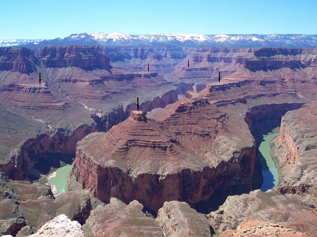
I was able to find out more about the meander in this outlined area:
Here's the closeup image of the meander, which it turns out is named Point Hansbrough:
The photograph is incredibly rich in detail, so don't forget that you can click on it to see it enlarged. A key question that should be asked about Point Hansbrough is why the upper portion is sloped and the lower portion vertical. The answer is the differing rock hardnesses of the geologic layers. The upper sloped portion is the Supai Group, which is fairly hard sandstone, while the lower vertical portion is Redwall above Mauv, both much softer limestone. If you dig into the Redwall and Mauv layers you'll find that they're not really red. They're only stained red by water runoff from the overlying Supai Group. There was a point in time before the river had eroded down through the hard Supai Group layers into the softer Redwall and Mauv limestone layers. When the river finally did erode through the Supai Group it would have first occurred at a lower elevation many, many miles downstream from Point Hansbrough. Erosion through the limestone layers would be much faster than through the higher sandstone layers of the Supai Group, and in no time there would have been a good sized differential in height of the riverbed, i.e., a waterfall. Given the heavy sediment load of the Colorado and the much more rapid flow of water across a waterfall, the waterfall would have quickly cut back upstream, very neatly following the course of the river around all the turns and meanders. The nearly vertical sides of the Redwall and Mauv sections occurred because they were cut relatively rapidly, probably on the order of a few centuries. As mentioned before, when a river cuts into a landscape, or rockscape in this case, the riverbanks erode back away from the river. Each little sublayer of the Supai Group took thousands and thousands of years to erode away, and so the higher the Supai Group sublayer, the longer it has been eroding away. That's why each sublayer is so much smaller than the one below, and why the slope is around 45 degrees. The underlying Redwall and Mauv layers that were all eroded away quickly leaving vertical sides have also been eroding away. Notice the very deep scree at the base of the Mauv just above river level, which is the debris from all the above layers. Those who have memorized all the layers of the Grand Canyon might ask, "What about the Temple Butte layer that lies between the Redwall and the Mauv?" The answer is that it isn't present here. In many parts of the canyon the Temple Butte is only partly eroded away, but at Point Hansbrough it is completely eroded away, and I expect some of the Mauv, too. But here's an image from just a short ways downstream of Point Hansbrough of a small smile-shaped portion of Temple Butte Limestone underlain by Mauv limestone and overlain by Redwall:
Source This is a much more clear illustration of the effects on erosion on layers of an uplifted region before a subsequent subsidence when it begins collecting sediment again. A stream or river eroded a channel into the top of the Mauv, the region subsided and the channel filled with limestone sediment that we now call the Temple Butte, then the region was uplifted again and the Temple Butte eroded away in this area all the way down to the Mauv, except for this little section of creek or riverbed. --Percy
|
||||||||||||||||||||||||||||||||||||||||||
|
Dr Adequate Member (Idle past 305 days)  Posts: 16113 Joined: |
Here's DR. A's SLEAZEBALL SUMMARY, MSG 853 I complained about in MY MESSAGE 874 which got ignored because everybody wants to make a federal case about the meanders, which I DO NOT CARE ABOUT. But I do care about Dr. A's blatantly unfair misrepresentation of my argument, which five of you nevertheless CHEERED. If you track back from that post of his you'll even find him taking my careful description of the tectonic activity I had in mind OUT OF CONTEXT, and I complained at the time. BUT YOU STILL ALL APPLAUD THIS PIECE OF SLIMEBALL "DEBATING." THE CLAIM THAT EVC HAS ANYTHING WHATEVER TO DO WITH SCIENCE IS BELIED BY THE DEVIOUS ANTICS OF DR. A ALONE, WHICH ARE LEGION HERE. WHAT A JOKE. Ah yes, my devious antics are legion. I feel that I should have a horde of minions and a maniacal laugh. But could you be more precise in your complaints? What is it you feel I've taken out of context? The only clue you give us is that it's a "careful description" of something and ... no, I can't find anywhere you've done that. It's evidently not your forte.
|
||||||||||||||||||||||||||||||||||||||||||
|
herebedragons Member (Idle past 879 days)  Posts: 1517 From: Michigan Joined: |
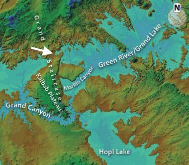
Wow what a beautiful image. There really is incredible detail.
I marked the image below with arrows that seem to indicate where there once was a level plain. It appears to be at the upper part of the Supai group. You can even see similar features in the background, but its difficult to tell if they are on the same plane.
This area looks to have been eroded rapidly by a much broader river creating a wide flood plain which the river eventually could have settled into and began its meandering. I am not sure how the time frame would work out or if this idea is supported in other parts of the canyon, but it is one of the first features I noticed when I looked at this image. HBD Edited by herebedragons, : fix image linkWhoever calls me ignorant shares my own opinion. Sorrowfully and tacitly I recognize my ignorance, when I consider how much I lack of what my mind in its craving for knowledge is sighing for. But until the end of the present exile has come and terminated this our imperfection by which "we know in part," I console myself with the consideration that this belongs to our common nature. - Francesco Petrarca "Nothing is easier than to persuade people who want to be persuaded and already believe." - another Petrarca gem.
|
||||||||||||||||||||||||||||||||||||||||||
|
RAZD Member (Idle past 1426 days)  Posts: 20714 From: the other end of the sidewalk Joined:
|
Hi Chuck 77
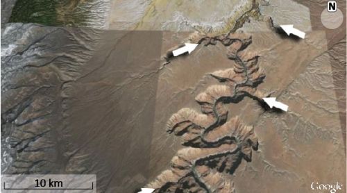
Seems you've removed your post. The reference was Grand canyon origin flood - creation.com The first thing I noticed was this image
quote: The arrow is only one of many places that are lower down than the ridge elevation would have been without the Grand Canyon. Another one is south of the canyon in line with the "Hopi Lake" label, and another further south from that. What is of interest is that NONE of these other low points show ANY evidence of water channel erosion across them, even though they are several hundred feet lower. Curiously the only place I can find reference to "Hopi Lake" is in creationist literature. Similar for "Grand Lake" as a prehistoric lake, even though there is a Grand Lake in NW Colorado. I also find it curious that the full extent of these lakes are not shown ... perhaps because to do so would expose the existing low points that would have provided outflow.
quote: Actually it doesn't, but other than that there is no explanation for why there is NO evidence of water erosion over those lower points ... that issue seems to be forgotten, once it has been used to discredit the "breached-dam theory" ... even though the same problem applies to the "Receding Flood Scenario" (which they have the honesty? not to label as a theory). Then there is this fantasy scenario:
quote: What the water will do is increasingly flow around the obstruction and erode the sides and the top of the whole mound until it was all gone. All gone. Nowhere in the world is there an example of this receding water making a channel through high points the water flows over. Nowhere, not even in those tidal flats. Furthermore, where the Grand Canyon crosses the ridge is not the highest point but up the side -- it rises higher to the north before dropping down to that obstinate arrow location -- so even this fantasy fails by its own argument. And this process -- even if it did work -- would still have eroded just as big (if not bigger due to more flow) channels over the low point marked on the map (and all the others that aren't shown). There is STILL no explanation for why there is NO water erosion channel across this location or other low point locations. This is typical half-truths mixed with conjecture. It fails to explain the lack of an erosion channel either north or south of the Grand Canyon which would have had to have as much if not more flow than the Grand Canyon in its infancy. It misrepresents how flows over landscape of varying heights erode the land, and it does not explain why the Grand Canyon crosses the ridge at a location that is neither the highest point nor the lowest point. Nor does it explain the meander of the whole canyon. It does not explain the evidence. What you have are a bunch of cobbled together conjectures forced to fit the existing canyon location and formation and forced to fit a flood scenario with stuff that doesn't happen anywhere else in the world. It's magic. Enjoy. Edited by RAZD, : ..by our ability to understand Rebel American Zen Deist ... to learn ... to think ... to live ... to laugh ... to share. Join the effort to solve medical problems, AIDS/HIV, Cancer and more with Team EvC! (click)
|
||||||||||||||||||||||||||||||||||||||||||
|
JonF Member (Idle past 189 days) Posts: 6174 Joined: |
Image link is dead.
|
||||||||||||||||||||||||||||||||||||||||||
|
|
Do Nothing Button
Copyright 2001-2023 by EvC Forum, All Rights Reserved
![]() ™ Version 4.2
™ Version 4.2
Innovative software from Qwixotic © 2024


 (1)
(1)