|

Understanding through Discussion |
|
|
Register | Sign In |
|
QuickSearch
| EvC Forum active members: 65 (9164 total) |
|
| |
| ChatGPT | |
| Total: 916,483 Year: 3,740/9,624 Month: 611/974 Week: 224/276 Day: 0/64 Hour: 0/1 |
| Thread ▼ Details |
|
Member (Idle past 1427 days)  Posts: 20714 From: the other end of the sidewalk Joined: |
|
Thread Info
|
|
|
| Author | Topic: If Caused By Flood Drainage Why is the Grand Canyon Where It IS? | ||||||||||||||||||||||||||||||||||||||||||||||
|
RAZD Member (Idle past 1427 days) Posts: 20714 From: the other end of the sidewalk Joined:
|
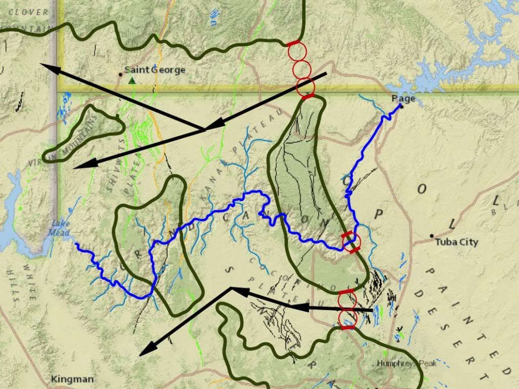
It seems that creationists are drawn to the Grand Canyon like moths to a flame ...
Here is a slightly different slant on the Grand Canyon debate: Why does the canyon cross two high ridges when paths north and south are at lower elevations?
The darker green is higher than the lighter green, the red outlines would be the topographic level dividing dark from light. So IF the canyon is formed by catastrophic flood flows draining the purported WWF, then
Does catastrophic flood drainage flow go magically uphill? Creationists claiming the Grand Canyon is due to catastrophic flood drainage got some 'splainin' to do. Enjoy Edited by RAZD, : clrty Edited by RAZD, : list db Edited by RAZD, : . Edited by RAZD, : .by our ability to understand Rebel☮American☆Zen☯Deist ... to learn ... to think ... to live ... to laugh ... to share. Join the effort to solve medical problems, AIDS/HIV, Cancer and more with Team EvC! (click)
|
||||||||||||||||||||||||||||||||||||||||||||||
|
Admin Director  Posts: 13023 From: EvC Forum Joined: Member Rating: 1.9
|
Thread copied here from the If Caused By Flood Drainage Why is the Grand Canyon Where It IS? thread in the Proposed New Topics forum.
|
||||||||||||||||||||||||||||||||||||||||||||||
|
RAZD Member (Idle past 1427 days) Posts: 20714 From: the other end of the sidewalk Joined: |
Here is creationist Kent Hovind and his (bad) argument for how the Grand Canyon was made:
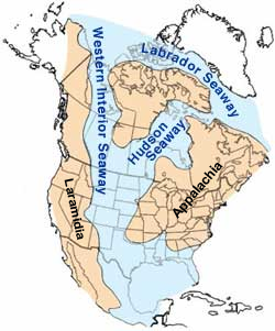
https://www.youtube.com/watch?v=ze5A2pua1E4 Typical mixture of some fact, some twaddle and a lot of innuendo and misrepresentation. Note that the map in Message 1 shows why Hovind's explanation is completely bogus and doesn't work by his own argument that water does not flow uphill -- where the Grand Canyon crosses the ridge is not the lowest point of the ridge, but up on a slope to a high point between two lower points, so if he was correct then the canyon would be in a different location, one north or south of the current location as shown on the map. Meadow Creek, btw, is a "barbed" connection , as are many other tributaries to the Colorado River west of the ridge, so his assertion that this never happens unless it is backflow off a dam is just more twaddle. There is no such general rule that tributaries can only connect to another river at acute angles -- water takes the path of least energy, whatever that is and wherever it leads. As best I can figure, his large lakes and beaches are actually the inland sea that transgressed and regressed several times over a lot of the middle states, leaving many beach deposits and marine sediments during the late Cretaceous to early Paleogene, and which were saltwater not fresh. Western Interior Seaway - Wikipedia
quote: Enjoy Edited by RAZD, : barbed Edited by RAZD, : seaway Edited by RAZD, : clrty Edited by RAZD, : ... Edited by RAZD, : .by our ability to understand Rebel☮American☆Zen☯Deist ... to learn ... to think ... to live ... to laugh ... to share. Join the effort to solve medical problems, AIDS/HIV, Cancer and more with Team EvC! (click)
|
||||||||||||||||||||||||||||||||||||||||||||||
|
roxrkool Member (Idle past 1011 days)  Posts: 1497 From: Nevada Joined:
|
If I remember correctly, the Colorado River displays many examples of stream capture. Maybe that's something to include in this discussion as well. Or is that what you meant by "barbed connection?"
Here's a quick resource to help things along from Geology of National Parks, Volume 2:
quote:
|
||||||||||||||||||||||||||||||||||||||||||||||
|
RAZD Member (Idle past 1427 days) Posts: 20714 From: the other end of the sidewalk Joined: |
Thanks roxrkool, not sure that will help the creationist dilemma though.
... While a trunk < Likely they mean the main stream that tributaries dump into (base elevations of the tributaries would be where they intersect the main trunk of the river). Enjoyby our ability to understand Rebel American Zen Deist ... to learn ... to think ... to live ... to laugh ... to share. Join the effort to solve medical problems, AIDS/HIV, Cancer and more with Team EvC! (click)
|
||||||||||||||||||||||||||||||||||||||||||||||
|
roxrkool Member (Idle past 1011 days) Posts: 1497 From: Nevada Joined: |
Oh yes, duh! Like the 'trunk' of a tree. That makes perfect sense. I'm not a hydrologist/hydrogeologist so some of the terminology is unknown to me.
Well I don't think anything other than Creationist literature is going to help them in any discussion involving geology. But I thought perhaps understanding a few of the main controlling factors in stream development was handy: base level, gradient, and stream capture. When I first learned the concept of stream capture (or piracy), I thought it was absolutely fascinating. But that was pretty much the only thing I enjoyed about hydro. Thanks for the help.  Edited by roxrkool, : No reason given.
|
||||||||||||||||||||||||||||||||||||||||||||||
|
RAZD Member (Idle past 1427 days) Posts: 20714 From: the other end of the sidewalk Joined:
|
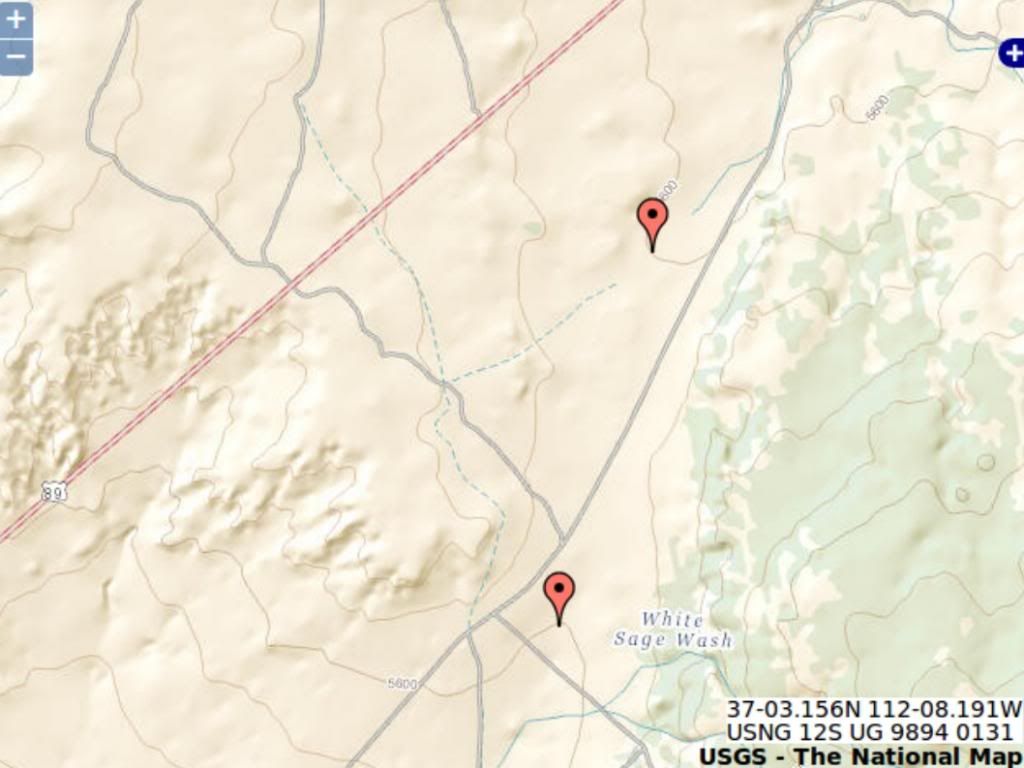
Interesting site - USGS topo maps interactive
http://store.usgs.gov/...OT&layout=6_1_61_48&uiarea=2%29/.do You can also download maps. Northern Route I captured this shot of where rte 89 crosses the ridge north of Grand Canyon:
The contours are at 40ft intervals and the two markers are on the 5600 ft contour with no other contour between them, so we know the highest point is less than 5640 ft. The rims of the canyon are 7250 ft (south) and 7750 (north) ... and the high point of the Kaibab plateau is over 8400 ft ... So the water would need to cut through (7250-5640 =) 1,610 ft of Kaibab Plateau before it gets to the elevation of the Rte 89 pass ... A location that does not show any evidence of a water erosion channel across the ridge. There's another pass a bit more north where another road crosses the Plateau, and its highest elevation is ~5800 ft and the width of water at the 7000 ft elevation is wider than the Grand Canyon ... A location that does not show any evidence of a water erosion channel across the ridge. That's a lot of water to just disappear or magically NOT flow downhill. Southern Route The highest elevation on the southern route shown is ~6460 ft, still ~800 ft below the canyon rim and this too would have a wide span of water at the 7000 ft elevation. A location that does not show any evidence of a water erosion channel across the ridge. Conclusion Any flood flow that could have cut the canyon in its current location with the ridge intact would also have cut drainage channels in these locations. There is no evidence of drainage channels across these passes. There was no flood flow. If flood flow carved the Grand Canyon then there should be at least two other canyons that would have been carved at the same time. Enjoy. Edited by RAZD, : .by our ability to understand Rebel☮American☆Zen☯Deist ... to learn ... to think ... to live ... to laugh ... to share. Join the effort to solve medical problems, AIDS/HIV, Cancer and more with Team EvC! (click)
|
||||||||||||||||||||||||||||||||||||||||||||||
|
RAZD Member (Idle past 1427 days) Posts: 20714 From: the other end of the sidewalk Joined:
|
Not only does the north passageway not show any evidence of water drainage across this low point in the ridge, but every pass in mountain ranges around the world do not show evidence of water drainage channel erosion.
What it comes down to is belief in a world wide flood is belief in a deceitful god that not only hides his work, but makes it look like an old earth, or ... ... the earth is old, very very very old. Get used to it. Enjoyby our ability to understand Rebel American Zen Deist ... to learn ... to think ... to live ... to laugh ... to share. Join the effort to solve medical problems, AIDS/HIV, Cancer and more with Team EvC! (click) |
||||||||||||||||||||||||||||||||||||||||||||||
|
Diomedes Member  Posts: 995 From: Central Florida, USA Joined:
|
Does catastrophic flood drainage flow go magically uphill? Well clearly, the fast moving water become ionized, thereby making it susceptible to a magnetic field. During the flood, the magnetic field of the Earth increased by MASSIVE orders of magnitude, thereby creating a 'pull' on the ionized water, making it 'magically' flow up hill! See? It's simple! And at the same time, the Earth was in danger of attack from Lord Xenu and his fleet of spaceships. Fortunately, the greatly increased power of the Earth's magnetic field ended up negating Lord Xenu's deflector shields, thereby causing his ships to burn up in our atmosphere. It's all SO obvious if you look at the evidence....
|
||||||||||||||||||||||||||||||||||||||||||||||
|
RAZD Member (Idle past 1427 days) Posts: 20714 From: the other end of the sidewalk Joined:
|
Well clearly, the fast moving water become ionized, thereby making it susceptible to a magnetic field. During the flood, the magnetic field of the Earth increased by MASSIVE orders of magnitude, thereby creating a 'pull' on the ionized water, making it 'magically' flow up hill! ... D'oh! Not just uphill but into the atmosphere as ions that then combined with other elements in the atmosphere to make the post noachin atmosphere and accounting for changes to 14C content and radioactivity in general ...
It's all SO obvious if you look at the evidence.... You are SO right.  by our ability to understand Rebel American Zen Deist ... to learn ... to think ... to live ... to laugh ... to share. Join the effort to solve medical problems, AIDS/HIV, Cancer and more with Team EvC! (click)
|
||||||||||||||||||||||||||||||||||||||||||||||
|
|
Do Nothing Button
Copyright 2001-2023 by EvC Forum, All Rights Reserved
![]() ™ Version 4.2
™ Version 4.2
Innovative software from Qwixotic © 2024