|

Understanding through Discussion |
|
|
Register | Sign In |
|
QuickSearch
| EvC Forum active members: 66 (9164 total) |
|
| |
| ChatGPT | |
| Total: 916,477 Year: 3,734/9,624 Month: 605/974 Week: 218/276 Day: 58/34 Hour: 1/3 |
Summations Only | Thread ▼ Details |
|
Thread Info
|
|
|
| Author | Topic: Why the Flood Never Happened | ||||||||||||||||||||||||||||||||||||||||||||||||
|
RAZD Member (Idle past 1427 days)  Posts: 20714 From: the other end of the sidewalk Joined:
|
... everybody wants to make a federal case about the meanders, which I DO NOT CARE ABOUT. ... Because the meanders prove you are wrong. Enjoy. Edited by RAZD, : .by our ability to understand Rebel American Zen Deist ... to learn ... to think ... to live ... to laugh ... to share. Join the effort to solve medical problems, AIDS/HIV, Cancer and more with Team EvC! (click)
|
||||||||||||||||||||||||||||||||||||||||||||||||
|
RAZD Member (Idle past 1427 days) Posts: 20714 From: the other end of the sidewalk Joined:
|
Hi Chuck 77
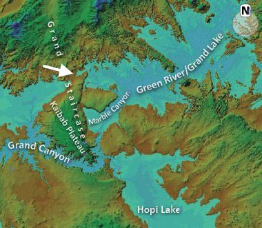
Seems you've removed your post. The reference was Grand canyon origin flood - creation.com The first thing I noticed was this image
quote: The arrow is only one of many places that are lower down than the ridge elevation would have been without the Grand Canyon. Another one is south of the canyon in line with the "Hopi Lake" label, and another further south from that. What is of interest is that NONE of these other low points show ANY evidence of water channel erosion across them, even though they are several hundred feet lower. Curiously the only place I can find reference to "Hopi Lake" is in creationist literature. Similar for "Grand Lake" as a prehistoric lake, even though there is a Grand Lake in NW Colorado. I also find it curious that the full extent of these lakes are not shown ... perhaps because to do so would expose the existing low points that would have provided outflow.
quote: Actually it doesn't, but other than that there is no explanation for why there is NO evidence of water erosion over those lower points ... that issue seems to be forgotten, once it has been used to discredit the "breached-dam theory" ... even though the same problem applies to the "Receding Flood Scenario" (which they have the honesty? not to label as a theory). Then there is this fantasy scenario:
quote: What the water will do is increasingly flow around the obstruction and erode the sides and the top of the whole mound until it was all gone. All gone. Nowhere in the world is there an example of this receding water making a channel through high points the water flows over. Nowhere, not even in those tidal flats. Furthermore, where the Grand Canyon crosses the ridge is not the highest point but up the side -- it rises higher to the north before dropping down to that obstinate arrow location -- so even this fantasy fails by its own argument. And this process -- even if it did work -- would still have eroded just as big (if not bigger due to more flow) channels over the low point marked on the map (and all the others that aren't shown). There is STILL no explanation for why there is NO water erosion channel across this location or other low point locations. This is typical half-truths mixed with conjecture. It fails to explain the lack of an erosion channel either north or south of the Grand Canyon which would have had to have as much if not more flow than the Grand Canyon in its infancy. It misrepresents how flows over landscape of varying heights erode the land, and it does not explain why the Grand Canyon crosses the ridge at a location that is neither the highest point nor the lowest point. Nor does it explain the meander of the whole canyon. It does not explain the evidence. What you have are a bunch of cobbled together conjectures forced to fit the existing canyon location and formation and forced to fit a flood scenario with stuff that doesn't happen anywhere else in the world. It's magic. Enjoy. Edited by RAZD, : ..by our ability to understand Rebel American Zen Deist ... to learn ... to think ... to live ... to laugh ... to share. Join the effort to solve medical problems, AIDS/HIV, Cancer and more with Team EvC! (click)
|
||||||||||||||||||||||||||||||||||||||||||||||||
|
RAZD Member (Idle past 1427 days) Posts: 20714 From: the other end of the sidewalk Joined: |
Yes, the only reference I could find to prehistoric water in that area was the inland sea in the Cretaceous. That would leave beaches, and salt water deposits ...
Lakes that large, that existed in the relatively recent past, will leave evidence, such as wave-cut terraces/benches, beach/shore deposits, etc. Those of us living in the Great Basin (Nevada and Utah) are quite familiar with paleo lacustrine geology in the form of the ancestral predecessor to the Great Salt Lake, Lake Bonneville. Which brings up another issue -- whatever happened to the water that must have filled the "Great Basin" -- an area that includes almost all Nevada and half of Utah that has no river outlet. All you have left is Great Salt Lake ... which is not salty enough for the whole basin to have evaporated ... Curiously I was looking at this earlier: Access denied
quote: It's interactive so you can move around and zoom in for greater detail. Amusingly I notice that each of the rivers that drain these watershed drainage systems meander ... every one. Other questions involve what are the lowest passes between watersheds and are there any drainage channels across those passes? (ie between the Colorado river watershed and the Rio Grande watershed). Enjoyby our ability to understand Rebel American Zen Deist ... to learn ... to think ... to live ... to laugh ... to share. Join the effort to solve medical problems, AIDS/HIV, Cancer and more with Team EvC! (click)
|
||||||||||||||||||||||||||||||||||||||||||||||||
|
RAZD Member (Idle past 1427 days) Posts: 20714 From: the other end of the sidewalk Joined:
|
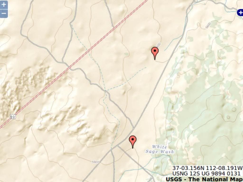
I'm (more or less) guessing groundwater flow. Wouldn't that leave caves and the like? And then there is Death Valley that is below sea level ... where does it drain to? Interesting sitehttp://store.usgs.gov/...OT&layout=6_1_61_48&uiarea=2%29/.do I captured this shot of where rte 89 crosses the ridge north of Grand Canyon:
The contours are at 40ft intervals so we know the highest point is less than 5640 ft. The rims of the canyon are 7250 ft (south) and 7750 (north) ... and the high point of the Kaibab plateau is over 8400 ft ... So the water would need to cut through (7250-5640 =) 1,610 ft of Kaibab Plateau before it gets to the elevation of the Rte 89 pass ... A location that does not show any evidence of a water erosion channel. That's a lot of water to just disappear or magically NOT flow downhill. Enjoy Edited by RAZD, : piclinkby our ability to understand Rebel☮American☆Zen☯Deist ... to learn ... to think ... to live ... to laugh ... to share. Join the effort to solve medical problems, AIDS/HIV, Cancer and more with Team EvC! (click)
|
||||||||||||||||||||||||||||||||||||||||||||||||
|
RAZD Member (Idle past 1427 days) Posts: 20714 From: the other end of the sidewalk Joined: |
But they all did not drain into Great Salt Lake. There are dry basins full of salts all over Nevada and NW Utah between every range. They extend up unto SE Oregon, where we have the Alvord Desert and other huge salt flats. Ok, but the point is that there is no outlet for water that would have to fill that basin to over 7000 ft and that means some 3000 ft of water. Sea water. Salty water. Enjoyby our ability to understand Rebel American Zen Deist ... to learn ... to think ... to live ... to laugh ... to share. Join the effort to solve medical problems, AIDS/HIV, Cancer and more with Team EvC! (click)
|
||||||||||||||||||||||||||||||||||||||||||||||||
|
RAZD Member (Idle past 1427 days) Posts: 20714 From: the other end of the sidewalk Joined:
|
The idea that a rock, in fact a gigantic rock pancake of sorts ... a gigantic rock pancake, I say, that may stretch for hundreds or even thousands of miles across a continent, ... No problem with this observation Faith, we observe this in many places, some disturbed and others not. We also observe the assortment of particles that make up the rocks, the materials they are made of, and any evidence of metamorphosis and bending and erosion.
... somehow represents a particular time period in Earth's history, IS ABSURD. ... And yet you too think they represent a "particular time period" -- we just disagree about the time period.
... It assumes the idea that a specific kind of sediment, and ONLY that sediment, collected over such a huge distance by normal means we observe today, ... No, you can have mixed deposits, such as boulders in sandstone that come from older rock and pyroclastic rocks mixed in clay shale.
... and that a peculiar assemblage of living creatures managed to die normal deaths over normal spans of time and get fossilized therein ... and some that span several deposition layers, but yes this is observed.
... . And that this process repeated itself from time to time with a DIFFERENT sediment each time, for hundreds of millions of years, rock pancakes ... Or with the same sediments or with NO sediments (chalk cliffs for example), but yes we see continued sedimentation occurs and we observe that some times the process is terrestrial and sometimes it is marine -- from the type, shape and formation of the rocks. We see fine layers deposited over coarse layers in periodic deposits in many lakes due to seasonal variations in the inflow rate and volume. We observe similar alternating fine and coarse layers in rocks that have lithified over time, and we observe that all these layers contain some evidence of life going on while the layers are formed. We see the growth of marine deposits with brachiopods growing on old shells of dead brachiopods that are still attached to older dead brachiopods in deposits that are many feet in thickness, brachiopods with growth rings on their shells showing their relative ages and from this we can estimate the amount of time it took for those feet of thickness to be deposited. We observe slate layers below sandstone and conglomerate stone, where the slate is formed from clay which is very fine compared to either sandstone or conglomerate.
... so that we now have a record in these rock pancakes of former periods of time on the planet, with very specific flora and fauna etc etc etc ... Yep. Some are index fossils and can be used to track the dates of the rocks so that when we see sedimentary rock "A" with index fossil "X" and a different sedimentary rock "B" with the same index fossil "X" we have high confidence that they are the same age even though we can only date one type of rock by some method or other. Oh ... did I mention that several different sedimentary deposits can occur at the same time in different places?
... . And all this is supposed to have occurred by normal means of sediment deposition, by streams for instance, and seas ... Just as we observe all over the world today.
... that in defiance of all known means keep rising and falling to accomplish this feat. ... Actually it is in accordance with known, observed and measured tectonic activity.
... I mean, REALLY, you poor dear human patsies, REALLY! So pure fantasy is better?
The strata are not a record of evolving life, ... the strata are is a record of a massive DEATH. Curiously death is a part of evolution, without death evolution would not occur. Massive death accumulated over massive time.
... Geology is all about a gigantic GRAVEYARD. Indeed. Some 99.9% of all known past and present life-forms are extinct -- in several different and distinct mass extinction events as well as over time between extinction events since the beginning of life on earth some 3.5 billion years ago. Enjoyby our ability to understand Rebel American Zen Deist ... to learn ... to think ... to live ... to laugh ... to share. Join the effort to solve medical problems, AIDS/HIV, Cancer and more with Team EvC! (click)
|
||||||||||||||||||||||||||||||||||||||||||||||||
|
RAZD Member (Idle past 1427 days) Posts: 20714 From: the other end of the sidewalk Joined: |
... the rest of you just keep wanting to bury MY point and I'm determined to keep it on the table. Repeating misinformation doesn't make it any more valid. Now I know that your flood scenario is false because:
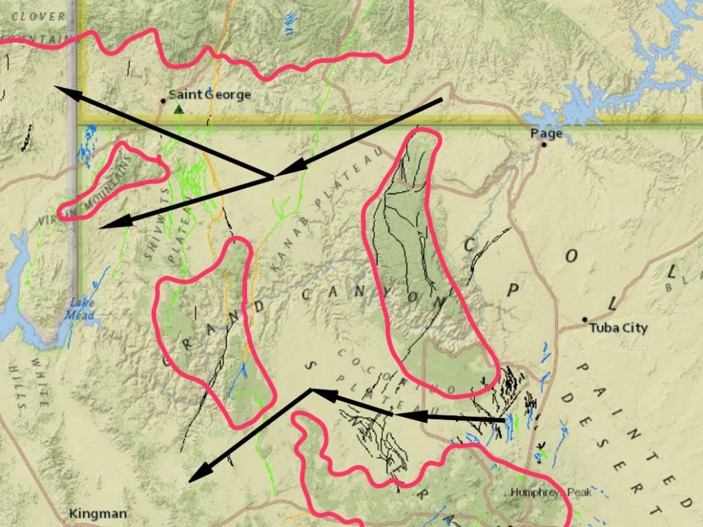
If Caused By Flood Drainage Why is the Grand Canyon Where It IS?: Why does the canyon cross two high ridges when paths north and south are at lower elevations?
The darker green is higher than the lighter green, the red outlines would be the topographic level dividing dark from light. So IF the canyon is formed by catastrophic flood flows draining the purported WWF, then
Does catastrophic flood drainage flow go magically uphill? Creationists claiming the Grand Canyon is due to catastrophic flood drainage got some 'splainin' to do. The topic of this thread is "Why the Flood Never Happened" and this fits into the topic quite well.
Message 7: Northern Route I captured this shot of where rte 89 crosses the ridge north of Grand Canyon:
http://i862.photobucket.com/...onRoute89pass_zps22cb79e8.jpg The contours are at 40ft intervals and the two markers are on the 5600 ft contour with no other contour between them, so we know the highest point is less than 5640 ft. The rims of the canyon are 7250 ft (south) and 7750 (north) ... and the high point of the Kaibab plateau is over 8400 ft ... So the water would need to cut through (7250-5640 =) 1,610 ft of Kaibab Plateau before it gets to the elevation of the Rte 89 pass ... A location that does not show any evidence of a water erosion channel across the ridge. There's another pass a bit more north where another road crosses the Plateau, and its highest elevation is ~5800 ft and the width of water at the 7000 ft elevation is wider than the Grand Canyon ... A location that does not show any evidence of a water erosion channel across the ridge. That's a lot of water to just disappear or magically NOT flow downhill. Southern Route The highest elevation on the southern route shown is ~6460 ft, still ~800 ft below the canyon rim and this too would have a wide span of water at the 7000 ft elevation. A location that does not show any evidence of a water erosion channel across the ridge. Conclusion Any flood flow that could have cut the canyon in its current location with the ridge intact would also have cut drainage channels in these locations. There is no evidence of drainage channels across these passes. There was no flood flow. If flood flow carved the Grand Canyon then there should be at least two other canyons that would have been carved at the same time. And both of those should have been bigger than the Grand Canyon because they would have started with more flow. You have said that at the beginning of the Flood carving the water filled it to the top -- so no matter how you cut the cake there should have been massive channel erosion in these two places. There is no such evidence there (or on any other mountain pass) so your model is false. It doesn't matter what you understand about geology and science this is just plain simple observation: it doesn't take a rocket scientist to look at the topography and understand that flood waters did not drain across these areas at any time. Enjoy. Edited by RAZD, : photo linksby our ability to understand Rebel☮American☆Zen☯Deist ... to learn ... to think ... to live ... to laugh ... to share. Join the effort to solve medical problems, AIDS/HIV, Cancer and more with Team EvC! (click)
|
||||||||||||||||||||||||||||||||||||||||||||||||
|
RAZD Member (Idle past 1427 days) Posts: 20714 From: the other end of the sidewalk Joined:
|
Top 5 Creationist Claims About Grand Canyon: #4 Grand Canyon Rocks Were Made By Noah’s Flood (Part II) | National Center for Science Education
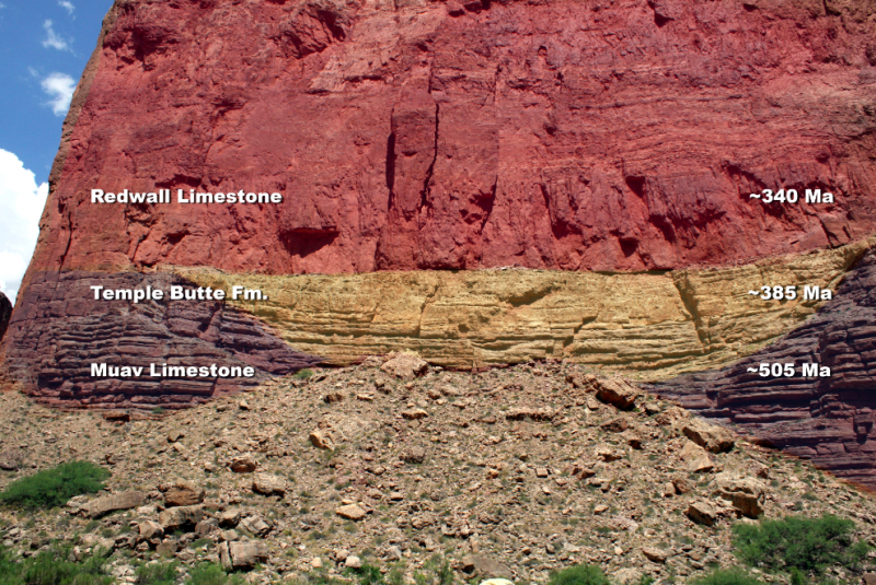
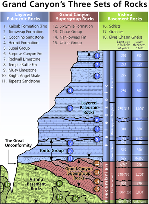
quote: Bold for emphasis That's a river channel Faith. where the Temple Butte Formation fills in the channel cut into the Muav Limestone. One of many such depositions on both sides of the canyon carved by a ... wait for it ... meandering river. Those are layers 7, 8 and 9 in the cross-section we have seen before, and the unconformities here have been pointed out to you before. It is also shown in part 1: Top 5 Creationist Claims About Grand Canyon: #4 Grand Canyon Rocks Were Made By Noah’s Flood (Part I) | National Center for Science Education
Which bears reading as well as the earlier part on claim #5Page not found | National Center for Science Education How do you explain a water channel at that depth? How do you explain it meandering back and forth across the canyon? Temple Butte Formation - Wikipedia
quote: Here are other pictures of other channel crossings, not colorized:
Enjoy Edited by RAZD, : . Edited by Admin, : Rerender for mobile usability. Edited by Admin, : Render with a narrower first image for mobile usability.by our ability to understand RebelAmericanZenDeist ... to learn ... to think ... to live ... to laugh ... to share. Join the effort to solve medical problems, AIDS/HIV, Cancer and more with Team EvC! (click)
|
||||||||||||||||||||||||||||||||||||||||||||||||
|
RAZD Member (Idle past 1427 days) Posts: 20714 From: the other end of the sidewalk Joined: |
yeah, but I thought maybe the colorized picture would make it clear.
Of course you realize that the problem for creationists is that if the canyon was NOT carved by the purported flood then it is obvious that the flood did not occur. They are trapped into it  Edited by RAZD, : .by our ability to understand Rebel American Zen Deist ... to learn ... to think ... to live ... to laugh ... to share. Join the effort to solve medical problems, AIDS/HIV, Cancer and more with Team EvC! (click)
|
||||||||||||||||||||||||||||||||||||||||||||||||
|
RAZD Member (Idle past 1427 days) Posts: 20714 From: the other end of the sidewalk Joined: |
Funny, the Muav and the Temple Butte limestones look identical to me, at least the lower part of the Temple and the Muav, except for the color that's been added to distinguish them, and the barely discernible line that you romanticize into an ancient riverbed. Do riverbeds normally take such a neatly scooped out rounded form? Not that I've ever noticed. Not always but also certainly it happens sometimes, and other views of this channel in different parts of the canyon wall look different. Certainly the bottom portions of riverbeds can be shaped like this and upper banks could have been eroded away with the top of the Temple Butte Formation. And it's not me, Faith, but a geologist that made the colorized picture along the delineation between the formation -- a delineation that is not invented nor imagined but one that can readily be identified in the field. Of course that means going there and getting within arms reach to see clearly the difference between two rocks. The rest of your post is an amusing attempt by you to make up something on the spot to explain this formation. It would be hysterical if it were not pathetic at the same time.
... it doesn't strike me as a great difficulty for the Flood model even if I can't say exactly how it happened. This is you time and again saying that you can't explain it by your model but you don't think it is a problem for your model: the epitome of turning a blind eye to the evidence that time and again shows your fantasy to be wrong. If we took all the times you have said this on this thread alone it would make for a long post, yet you blunder on sure that you can invent some other magic behavior that defies gravity, hydrology, geology and reason.
Message 984: Here are other pictures of other channel crossings, not colorized:
There is an obvious unconformity at the top and bottom of the Temple Butte Formation and the top of the Muav formation -- you can see it clearly in these pictures. This is an unconformity that makes your limestone cave concept insufficient as an explanation, and this is an unconformity that proves your piles of pancake layers fantasy is wrong.
Message 997: ... The ONLY exception, which I allow although I disagree with it, is the Great Unconformity beneath the canyon. ALL the other disturbances occurred to the stack AFTER the layers were all in place. Meandering river in limestone? What? ABE: I'll get to that in the next post. Message 1007: The picture I put up of erosion was to demonstrate the KIND of erosion I expected to see between layers, as opposed to the usual bit of rubble that passes for erosion, not the size of it. ... Just like the meandering stream shown by the Temple Butte formation ... Yes that nasty Temple Butte unconformity shows that your fantasy is false ... But you will pretend that it isn't relevant, not important, don't look behind the curtain ... you'll get around to making up some impossible scenario for it ... But you are only fooling yourself. Enjoy Edited by RAZD, : ... Edited by RAZD, : ...by our ability to understand Rebel American Zen Deist ... to learn ... to think ... to live ... to laugh ... to share. Join the effort to solve medical problems, AIDS/HIV, Cancer and more with Team EvC! (click)
|
||||||||||||||||||||||||||||||||||||||||||||||||
|
RAZD Member (Idle past 1427 days) Posts: 20714 From: the other end of the sidewalk Joined: |
Good idea. Only it would be better if you actually UNDERSTOOD the point I'm trying to make first. Try understanding the point Pollux was making first. You have cited one book and claimed that it was all imagination so therefore all methods of measuring age are imaginary. This is bad logic even for you. But I bet you will never take the challenge to discuss age on that thread and that in the unlikely event you do, that you will quickly make some excuse to leave ...
Age Correlations and An Old Earth, Version 2 No 1 In case you want to try. Or perhaps you would like to take up where mindspawn left off ...
Great debate: radiocarbon dating, Mindspawn and Coyote/RAZD or where S1WC left off ...
Age of the Earth in Stages, Great Debate, S1WC and RAZD only Or I can start another thread just for you. Curious that creationists just seem to disappear when confronted with this evidence. It starts with a tree in the Sierra Nevadas in California that is 5,063 years old and still living, with dead trees still standing that are over 7,000 years old, and with a Bristlecone pine dendrochronology that extends to 6,700 BCE for starters. Simply by counting tree rings, one year at a time. Objective empirical data. The earth is old Faith, very very old: get used to it. Enjoyby our ability to understand Rebel American Zen Deist ... to learn ... to think ... to live ... to laugh ... to share. Join the effort to solve medical problems, AIDS/HIV, Cancer and more with Team EvC! (click)
|
||||||||||||||||||||||||||||||||||||||||||||||||
|
RAZD Member (Idle past 1427 days) Posts: 20714 From: the other end of the sidewalk Joined: |
That half moon shape carved in limestone and filled in with limestone just does NOT suggest a riverbed, sorry. Yet it matches your example for the kind of disturbance that you said should be observable.
That half moon shape carved in limestone and filled in with limestone just does NOT suggest a riverbed, sorry. Yet it is still top and bottom an unconformity in the layers showing erosion of the layers.
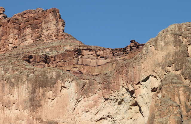
I honestly have NO idea what on earth you think you are saying ... Quite simply that you are wrong. You asked for evidence of erosion, and then deny evidence when it is provided. You state that there are no unconformities above the supergroup, and then deny evidence when it is provided. There is another unconformity at the Surprise Canyon Formation that also shows evidence of erosion between layers.
That's on top of the Redwall formation. That's erosional unconformities
But you will deny it and curl up in your armchair and say you can't see it so therefore it doesn't exist. You are blinded by belief in fantasy ... by your choice. Enjoy. Edited by RAZD, : .by our ability to understand Rebel American Zen Deist ... to learn ... to think ... to live ... to laugh ... to share. Join the effort to solve medical problems, AIDS/HIV, Cancer and more with Team EvC! (click)
|
||||||||||||||||||||||||||||||||||||||||||||||||
|
RAZD Member (Idle past 1427 days) Posts: 20714 From: the other end of the sidewalk Joined:
|
RAZD, you just aren't getting the Grand picture, if you'll pardon the pun. Oh I get it. it. it... Some people think a great floodcovered the whole world with mud pretending to know all they tried hard to show all but it was just another big dud. by our ability to understand Rebel American Zen Deist ... to learn ... to think ... to live ... to laugh ... to share. Join the effort to solve medical problems, AIDS/HIV, Cancer and more with Team EvC! (click)
|
||||||||||||||||||||||||||||||||||||||||||||||||
|
RAZD Member (Idle past 1427 days) Posts: 20714 From: the other end of the sidewalk Joined:
|
You love to declare me wrong based on some undecipherable comment or some picture or other but all you do is create confusion. No Faith, I say you are wrong because of the preponderance of evidence, the repeated occurrences of you saying something, someone shows it is false and you ignore it or make up some impossible fantasy to tell yourself you have a 'reasonable' explanation. Your confusion comes from your lack of understanding, from your fight to hold reality at bay. It's called cognitive dissonance -- cognitive dissonance actually interferes with your ability to understand information that counters strong belief.
What meandering stream? You showed a picture of a scooped-out shape in a wall of limestone, ... What was shown was one picture of one of the places where the prehistoric stream had crossed the canyon -- and the information that this happens in several places because the prehistoric stream meandered.
... with another limestone filling it. ... Curiously what fills an old stream or any depression for that matter is irrelevant: shocking news I know, but what ever sediment is next deposited will fill the depressions in the previous layer. The one for the surprise canyon for instance is filled by different materials.
... It has none of the characteristics of a riverbed. ... Says the person with no knowledge of hydrology.  This is your belief controlling your ability to understand what is before your eyes. What part of a scooped out shape would prevent water from flowing in that cross-section?
.... It's certainly not the sort of erosion one would expect to find on the surface of the earth, ... No Faith, it is very much what you should expect - a channel for river flow that appears in several places.
... , and besides, limestones are formed under water so why would you expect to find aerial features in it? ... Because we see such features in limestones that are exposed -- like the White Cliffs of Dover.
... All these are limestones, the Muav, the Temple Butte and the Redwall. ... So? They are different deposits, and the tops of each show erosion. This is like saying that because each layer was sedimentary that there is some special pleading that prevents erosion between their faces. The problem for you is that your scenario with all this limestone would not have any definition between these layers - it would all be one. That this is not the case is another element of reality demonstrating the erroneous thinking in your fantasy. And the Surprise Canyon Formation is not limestone -- so your logic is incomplete as well as erroneous.
... The Temple Butte is a mixture which also includes sand and clay ... As one should expect from a drainage channel.
... but it fills in the Muav ... As one should expect from a drainage channel in a layer that has had continued erosion.
... and is topped by the Redwall, ... And one would expect another layer of sedimentation to occur at some point.
... both limestones. ... Still irrelevant. We expect layers from additional sedimentary processes, but we don't expect one type of sediment to be more or less likely than any others. It's like throwing a single di -- the previous throw has no effect on the probability of the next throw. None.
... It is certainly no surface feature. ... Curiously your opinion is still not based on facts. It has been pointed out to you before that not only are these unconformities visible, but there is fossil evidence that shows they were surface features.
... It's some kind of sediment soup or slurry that cut a channel in the limestone beneath as it filled it in. Whatever it is, it is consistent with the Flood as it was clearly originally wet sediment and nothing that could remotely be described in terms of former landscape time eras. ... It's hilarious to see you making up ad hoc magical behavior of materials when evidence that you previously said should be visible if the old earth geological explanation of the Grand Canyon were correct is shown to you. Fantasy behavior unknown in the world today ... slurries deposited in sublayers in channels as it carves out material that magically disappears just like the rubble from the Great Unconformity process you describe. Hilarious and pathetic.
... as it was clearly originally wet sediment and nothing that could remotely be described in terms of former landscape time era ... Why geologists should be unable to describe wet sedimentation in an old river course is a real mystery Faith ... ... just because it is only seen almost anywhere?
... Besides, shouldn't it be considered a problem for the OE interpretation to find any sediment cutting into another? ... There are any number of places in the world where you can see river channels carved by meandering streams with old sections of riverbed that have been filled in when the river changed course and annual floods deposited sediments. It is not the sediment cutting the channel Faith, it is sediment filling the channel eroded previously by the river.
... I mean, these are supposedly TIME PERIODS, right? How can you have a time period cutting into another time period? ... It appears that your inability to grasp simple sequences of events is as unlimited when it comes to factual processes as it is when making up fantasy sequences. Surface is deposited ...Erosion occurs ... Rivers form ... Rivers behave like ... rivers and change channels as they behave like ... rivers when meandering ... Later sedimentation occurs and covers both the old riverbeds and the land beside it ... More erosion occurs ... More sedimentation occurs ... New rivers form ... the new rivers behave like ... rivers and change channels as they behave like ... rivers when meandering ... Later sedimentation occurs and covers both the old riverbeds and the land beside it ... That is all that is necessary to explain the Mauv Formation, the Temple Butte Formation, the Redwall Formation and the Surprise Canyon formation. Simple processes you can see happening in the world today.
... How can you have a time period cutting into another time period? ... Today cuts into the past all over the world Faith: that is what erosion is. What you cannot have is the past cutting into the present.
... Well, of course for that particular situation you forget it's a time period. That's all. Now it's a riverbed. ... A riverbed that represents a period in time, a period when erosion was occurring into the sedimentary layer below it, just as (SHOCKING NEWS) rivers do around the globe today.
... A riverbed of course that doesn't look like any actual riverbed on the planet but oh well.
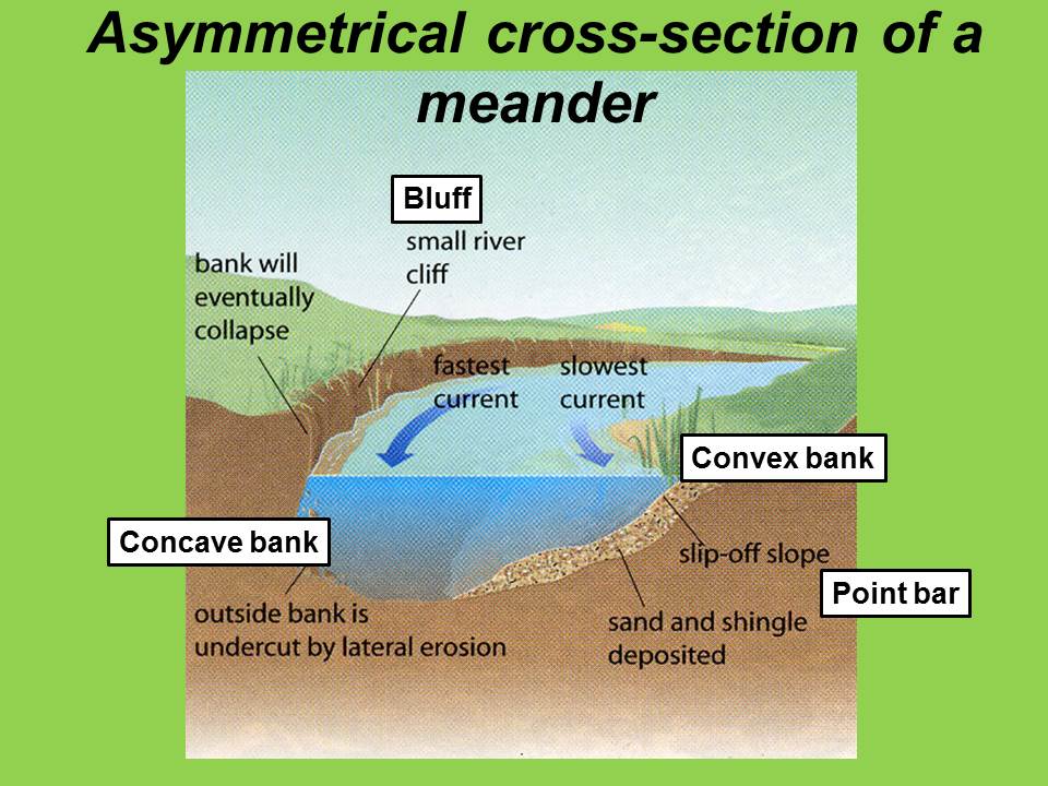
Hydrological flow characteristics to be expected in a stream\river section, showing how river flow action should affect the shape of the channel ... and an actual factual section of the same basic shape. Curiously there are other shapes that we also see:
Section at a bend and a plan view showing how the riverbed would change sections along its length.
Asymmetrical section in Temple Butte formation. Now I kind of have to admire your ability to make up stuff, as you certainly don't do it by half-measures. You go whole hog for denial of reality.
I actually don't know how to explain it, but as I say above since it was originally sediment in wet running form it fits with the Flood and not with your Time Period fantasy. I actually don't know how to explain it, but as I say, the moon is made of blue cheese, from cows jumping over it, and not by some jack and jill fantasy. Riiiiight. You don't know how geology works. You don't know how hydrology works. You don't know how the real world works. Enjoy.by our ability to understand Rebel American Zen Deist ... to learn ... to think ... to live ... to laugh ... to share. Join the effort to solve medical problems, AIDS/HIV, Cancer and more with Team EvC! (click)
|
||||||||||||||||||||||||||||||||||||||||||||||||
|
RAZD Member (Idle past 1427 days) Posts: 20714 From: the other end of the sidewalk Joined:
|
Well, you might as well get ready to welcome them, they're coming. Religious fanatics are already here, they just happen to be christian fanatics (you know, those people that blow up women's clinics and shoot doctors because of fanatical religious beliefs). It's the fanaticism that is dangerous, no matter the source. Enjoyby our ability to understand Rebel American Zen Deist ... to learn ... to think ... to live ... to laugh ... to share. Join the effort to solve medical problems, AIDS/HIV, Cancer and more with Team EvC! (click)
|
||||||||||||||||||||||||||||||||||||||||||||||||
|
|
Do Nothing Button
Copyright 2001-2023 by EvC Forum, All Rights Reserved
![]() ™ Version 4.2
™ Version 4.2
Innovative software from Qwixotic © 2024