|

Understanding through Discussion |
|
|
Register | Sign In |
|
QuickSearch
Summations Only | Thread ▼ Details |
|
Thread Info
|
|
|
| Author | Topic: Why the Flood Never Happened | |||||||||||||||||||||||||||||||||||||||
|
RAZD Member (Idle past 1427 days)  Posts: 20714 From: the other end of the sidewalk Joined: |
I see I was wrong about the shape of riverbeds, so thanks for that. ... Thank you.
... Nevertheless there is something really strange about this "riverbed" being filled with limestone instead of pebbles and the usual river bottom debris. ... and yet (a) it is a different limestone (b) the riverbed will be filled by something if there is another layer of deposition and (c) if the next layer is limestone then it is logical for this to fill the channel. They don't say it is pure limestone. USGS URL Resolution Error Page
quote: bold added for emphasis Looks like the channels were filled with rubble and then overlain by a more homogeneous sediment.
Let's just be clear that what I have been saying all along is that NORMAL EROSION is not seen between the layers, ... ... when you close your eyes to it.
... , and THIS IS NOT NORMAL EROSION either. ... Wrong again.
... This is just a half moon shape in limestone filled in with limestone while the layer above makes a STRAIGHT LINE connection with it. ... ... and wrong again. Other sections are different shapes, as would be expected. The top and the bottom surfaces (neglecting the obvious variations from erosion) form a long wedge shape from one end of the canyon to the other -- again as would be expected per roxrkool's post -- so one or the other (or both) violates your flat surfaces concept. The western end is 5 times the thickness of the eastern end.
... The whole formation is saggy and lumpy, deformation which occurred after deposition of the whole stack, but the connection line was clearly straight and horizontal originally, NOT what one would see from a long time at the surface of the earth. ... and wrong once again. The tops and bottoms of each of the four (count 'em ↠ 4 ↞ ...) layers are not saggy, lumpy or deformed in the same way at any point, each is different -- as would be expected from erosion.
As I said, I don't know how to explain this, but your explanation is certainly not acceptable. As I said, geologists do know how to explain this, but your explanation is certainly doesn't work. Enjoy.by our ability to understand Rebel American Zen Deist ... to learn ... to think ... to live ... to laugh ... to share. Join the effort to solve medical problems, AIDS/HIV, Cancer and more with Team EvC! (click)
|
|||||||||||||||||||||||||||||||||||||||
|
RAZD Member (Idle past 1427 days) Posts: 20714 From: the other end of the sidewalk Joined:
|
Right, all us Christians are out there blowing things up of course and murdering people. We're all just the same, all us religious fanatics. Remember that when the Muslims are about to hack off your head because you won't accept Allah. Not all Christians are religious fanatics just as not all Muslims are religious fanatics, and it doesn't matter which branch of religion a religious fanatic is from if they threaten lives.  by our ability to understand Rebel American Zen Deist ... to learn ... to think ... to live ... to laugh ... to share. Join the effort to solve medical problems, AIDS/HIV, Cancer and more with Team EvC! (click)
|
|||||||||||||||||||||||||||||||||||||||
|
RAZD Member (Idle past 1427 days) Posts: 20714 From: the other end of the sidewalk Joined: |
How does ooze lithify by the way, with nothing pressing on it from above? Several ways. See Limestone - Wikipedia and note that to cover all the different kinds of limestone, their compositions and formation process would fill a page.
Then later, like clockwork, hey it occurs to EVERY layer in the stack somehow or other, kind of like the Emperor's New Clothes I'd say, this DIFFERENT sediment, well, in this case it's just another calcareous ooze that's going to form a different limestone but it COULD have been sand dunes, ... Not quite. The fact that erosion has occurred is not because of clockwork or any plan, rather erosion occurred because the surface was exposed. For a long time. And yes the different layers of limestone have different compositions, hence the difference in colors and contents. (again see the wiki article Limestone - Wikipedia)
Of course it's ONLY in limestone that we see these "riverbeds," ... It's only in limestone that the evidence has been observed, not because they are limestone, but because that is what was on top when the erosion that is observed occurred.
And it shows up RIGHT ON TIME, too, never too early so that it mingles with the calcareous ooze, ... Ever heard of the argument from incredulity logical fallacy? What has happened is what has happened, it was not a predetermined sequence of events.
Except, of course, for the facts I've suggested above. ... Facts? I must have missed those in the flood of frantic fantasy.
Now of course you CAN get a meandering stream between the layers of limestone, in the real world that is. Show me. Enjoyby our ability to understand Rebel American Zen Deist ... to learn ... to think ... to live ... to laugh ... to share. Join the effort to solve medical problems, AIDS/HIV, Cancer and more with Team EvC! (click)
|
|||||||||||||||||||||||||||||||||||||||
|
RAZD Member (Idle past 1427 days) Posts: 20714 From: the other end of the sidewalk Joined: |
the same is said of islam.
but it doesn't matter who pulls the trigger, the gun still shoots. Enjoyby our ability to understand Rebel American Zen Deist ... to learn ... to think ... to live ... to laugh ... to share. Join the effort to solve medical problems, AIDS/HIV, Cancer and more with Team EvC! (click)
|
|||||||||||||||||||||||||||||||||||||||
|
RAZD Member (Idle past 1427 days) Posts: 20714 From: the other end of the sidewalk Joined: |
I really can hardly believe the nuttiness of what you are saying. ... Cognitive dissonance.
... There IS no erosion between layers of the strata of the sort that would have occurred on the surface if exposed for a long time. ... Isn't it amazing how much your undereducated opinion is completely unable to alter reality.
quote: That's four surface levels that exhibit the effects of erosion in addition to the Great Unconformity.
... That "riverbed" is NOT erosion, it's some kind of formation that occurs in limestone, no it is not merely incidental, it has something to do with its being limestone, and otherwise the lines between the layers are flat. Erosion does not flatten things. That is NONSENSE. You have yet to show an example of such erosion that meticulously sticks to the boundary between two limestone layers, eroding down into one and not up into the other, layers you claim are level so there would be no grade to the flow ... This of course is because no such erosion pattern exists.
Oh well. You keep accusing me of unreality but it's you that live there, not I. Curiously you are the one denying objective empirical observable evidence, and unable to support your fantasy with evidence. Enjoy.by our ability to understand Rebel American Zen Deist ... to learn ... to think ... to live ... to laugh ... to share. Join the effort to solve medical problems, AIDS/HIV, Cancer and more with Team EvC! (click)
|
|||||||||||||||||||||||||||||||||||||||
|
RAZD Member (Idle past 1427 days) Posts: 20714 From: the other end of the sidewalk Joined: |
Way back there HBD (herebedragons) put up a few diagrams of layers that extend for huge distances across North America. Nothing you've said is going on in the world now even begins to approach the extent of those layers. But the Flood could easily account for them.
I didn't see that post so I cannot comment. But it's also possible these immense units are actually different formations that were deposited at the same time, but in different basins or along a continental shelf. The west and east coasts of North America are pretty darn extensive and they are all depositing sand, carbonate at the same time. Ten million years from now, they would be linked geologically. Message 448 What the maps show is deposits of the same age, not necessarily the same rock formation as Faith has misinterpreted it. Enjoy.by our ability to understand Rebel American Zen Deist ... to learn ... to think ... to live ... to laugh ... to share. Join the effort to solve medical problems, AIDS/HIV, Cancer and more with Team EvC! (click)
|
|||||||||||||||||||||||||||||||||||||||
|
RAZD Member (Idle past 1427 days) Posts: 20714 From: the other end of the sidewalk Joined: |
Slow moving streams are incapable of moving pebbles. Their riverbeds will accumulate muck whose makeup is a function of the sediment carried by the stream, which is in turn a function of run-off upstream and the material in the landscape the river flows through. There should be a few pebbles and rocks in the sediments of the streambed that fall in from the riverbanks over time, but the vast majority of the bottom of slow moving streams should be a fine muck. And when spring floods occur, the water over the flood plain will be slowing down and depositing fine material as well. This is why flood plains are such good places for agricultural use -- they have good soil because of this process. The larger stones will be deposited near the baseline of the river where it exits the erosion area (mountains) in an alluvial fan. Finer sediments get carried further. One need only look at the muck deposited in and around buildings during floods to see that this consists of fine deposits rather than gravels and sand.
Floating organic debris is also carried by flood waters to the flood plains.  Edited by RAZD, : .by our ability to understand Rebel American Zen Deist ... to learn ... to think ... to live ... to laugh ... to share. Join the effort to solve medical problems, AIDS/HIV, Cancer and more with Team EvC! (click)
|
|||||||||||||||||||||||||||||||||||||||
|
RAZD Member (Idle past 1427 days) Posts: 20714 From: the other end of the sidewalk Joined: |
... To me that's really the main issue: how could a single flood have deposited all these layers??? That's the question a floodist needs to answer. But of course, there is no way to get that across to her. ... And more to the point why did it skip some places but deposit all around it and then put another layer on top of both. It like the mystery of the dog that didn't bark ... Enjoy ps cars do float. for a while ...by our ability to understand Rebel American Zen Deist ... to learn ... to think ... to live ... to laugh ... to share. Join the effort to solve medical problems, AIDS/HIV, Cancer and more with Team EvC! (click)
|
|||||||||||||||||||||||||||||||||||||||
|
RAZD Member (Idle past 1427 days) Posts: 20714 From: the other end of the sidewalk Joined: |
HBD himself, not I, identified the Mississippian as the Redwall limestone, and that particular deposit, the sediment itself, was said by UK creationist Paul Garner on the video I've posted a few times to be recognizable across the US and even in the UK. HBD also identified the Devonian as the Temple Butte formation, not I. He repeated these identifications in his Message 645 as well. I read that as identifying where the unconformity lies in the sequence and which age the Redwall formation is in. Perhaps HBD will clarify. by our ability to understand Rebel American Zen Deist ... to learn ... to think ... to live ... to laugh ... to share. Join the effort to solve medical problems, AIDS/HIV, Cancer and more with Team EvC! (click)
|
|||||||||||||||||||||||||||||||||||||||
|
RAZD Member (Idle past 1427 days) Posts: 20714 From: the other end of the sidewalk Joined: |
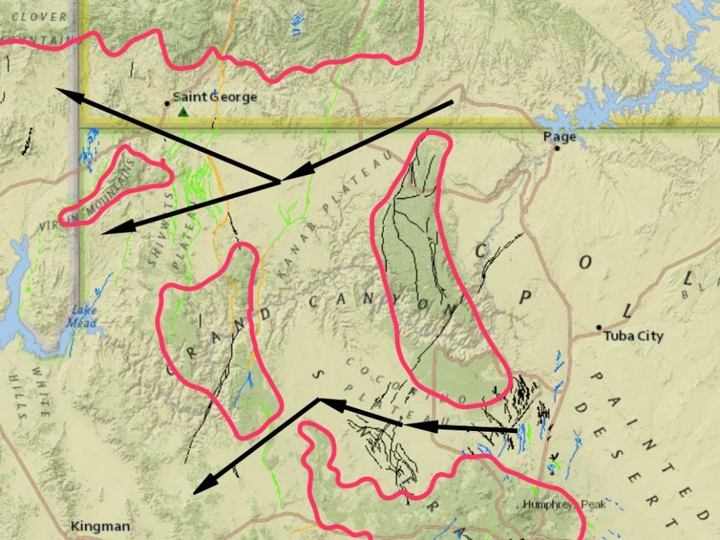
... The enormous size of the canyon requires a HUGE cataclysm to explain it which the Colorado River could not possibly explain And yet this "HUGE cataclysm" erosion started up the slope of a rise that was 1600 ft higher than the pass to the north, which at the level of the rim at the ridge crossing was miles wider than anywhere in the canyon ... ... and the canyon ridge crossing was 800 ft higher that the pass to the south, which also was miles wider than anywhere in the canyon ...
Compare the distance between the red lines in these two locations to the width of the grand canyon in the first picture ... And there is absolutely no evidence of any water carved channel across either of the passes. The purported flood somehow started well over the tops of these features but in the process of drainage somehow missed these wide open locations that would have carried several times the outflow you imagine for the Grand Canyon. Why? See If Caused By Flood Drainage Why is the Grand Canyon Where It IS? for more details. Edited by RAZD, : 2nd pic Edited by RAZD, : fin Edited by Adminnemooseus, : Made the unzoomed versions of the images a bit smaller. Edited by RAZD, : piclinkby our ability to understand Rebel☮American☆Zen☯Deist ... to learn ... to think ... to live ... to laugh ... to share. Join the effort to solve medical problems, AIDS/HIV, Cancer and more with Team EvC! (click)
|
|||||||||||||||||||||||||||||||||||||||
|
RAZD Member (Idle past 1427 days) Posts: 20714 From: the other end of the sidewalk Joined: |
Message 1082: ... . In the case of the GC it would have to do with the shape of the uplifted land and, I think, the cracking in the upper strata, that directed the flow of a huge quantity of water so that it cut out the canyon. it also of course ran all over the southwest and cut the formations of the Grand Staircase and scoured off the Kaibab plateau . ... RAZD you are describing the situation NOW. There was at least another mile or more in depth of strata above the current land surface, that was eroded away, I believe as a result of the uplifting land and the tectonic disturbances that followed the Flood, and right after the Flood the uplifting would most likely just have begun. And it did all this without leaving any trace of any water erosion channel from cataclysmic water flow in either of the north or south locations. Or carving a canyon larger than the Grand Canyon in either location ... which should have happened according to your model. Nothing. How?  Edited by RAZD, : .by our ability to understand Rebel American Zen Deist ... to learn ... to think ... to live ... to laugh ... to share. Join the effort to solve medical problems, AIDS/HIV, Cancer and more with Team EvC! (click)
|
|||||||||||||||||||||||||||||||||||||||
|
RAZD Member (Idle past 1427 days) Posts: 20714 From: the other end of the sidewalk Joined:
|
Where did the water go? ... I believe her model has the ocean bottoms sinking catastrophically as mountains rose, contrary to any know tectonic behavior, and meanwhile the middle east plate was perfectly stationary while everything else moved across oceans and even though the ark landed on a mountain that was formed within days by tectonic action so that Noah and family would not notice any shaking aftereffects. Perfectly reasonable eh?  by our ability to understand Rebel American Zen Deist ... to learn ... to think ... to live ... to laugh ... to share. Join the effort to solve medical problems, AIDS/HIV, Cancer and more with Team EvC! (click)
|
|||||||||||||||||||||||||||||||||||||||
|
RAZD Member (Idle past 1427 days) Posts: 20714 From: the other end of the sidewalk Joined: |
It went South and West into Arizona and California and down the Gulf of California. To the ocean that was also flooded ... but the bottoms suddenly sank catastrophically ... yes? No massive tidal waves eh? None south to the Rio Grande? Curious that I can look at virtually every river basin and see meandering streams and no catastrophic channeling. Edited by RAZD, : .by our ability to understand Rebel American Zen Deist ... to learn ... to think ... to live ... to laugh ... to share. Join the effort to solve medical problems, AIDS/HIV, Cancer and more with Team EvC! (click)
|
|||||||||||||||||||||||||||||||||||||||
|
RAZD Member (Idle past 1427 days) Posts: 20714 From: the other end of the sidewalk Joined: |
By the way, how did the ocean level rise enough, a mile or more above the base of the Grand Canyon and then whatever the depth of the ocean itself is, for the Kaibab limestone to deposit on the bottom of it? They were deposited before the uplift, if you remember that is before the river was cutting meanders into the floodplain. by our ability to understand Rebel American Zen Deist ... to learn ... to think ... to live ... to laugh ... to share. Join the effort to solve medical problems, AIDS/HIV, Cancer and more with Team EvC! (click)
|
|||||||||||||||||||||||||||||||||||||||
|
RAZD Member (Idle past 1427 days) Posts: 20714 From: the other end of the sidewalk Joined: |
LOOK FOR DEPTHS OF NONSTRATIFIED SEDIMENTS. ... What are those? Is this different from the Grand Canyon?
THAT'S WHERE MUCH OF IT WOULD HAVE ENDED UP, WITH THE RIVER RUNNING THROUGH IT. Why no catastrophic channel evidence Faith -- NONE. What you have are meandering streams with alluvial depositions in the flood plains and yes, they are stratified. by our ability to understand Rebel American Zen Deist ... to learn ... to think ... to live ... to laugh ... to share. Join the effort to solve medical problems, AIDS/HIV, Cancer and more with Team EvC! (click)
|
|||||||||||||||||||||||||||||||||||||||
|
|
Do Nothing Button
Copyright 2001-2023 by EvC Forum, All Rights Reserved
![]() ™ Version 4.2
™ Version 4.2
Innovative software from Qwixotic © 2024


 (1)
(1)