
|

Understanding through Discussion |
|
|
Register | Sign In |
|
QuickSearch
Summations Only | Thread ▼ Details |
|
Thread Info
|
|
|
| Author | Topic: Why the Flood Never Happened | |||||||||||||||||||||||||||||||||
Faith  Suspended Member (Idle past 1464 days)  Posts: 35298 From: Nevada, USA Joined: |
If we include these additional layers it only makes your problem considerably worse. Instead of an adjustment of just a mile, now the adjustment is 3 miles. Instead of your catastrophic flow cutting 3000 feet below sea level, now it has to be around 13,500 feet below sea level. That's even more ridiculous than before. That is an absolutely idiotic straw man. The strata built up over two miles ABOVE sea level. Obviously.
You would only be proposing something this ridiculous if you were failing to grasp the implications of the scenario you yourself proposed, so let me lay it out in greater detail. You're claiming that there was an additional 2 miles of sedimentary layers above the current top Kaibab layer, I .. AM .. NOT! Your straw man is getting bigger and more ridiculous by the second.
The strata that were above the current canyon rim were a little over ONE MILE deep, and can be seen in the Grand Staircase to the north. ONE MILE, Percy, you made up a nonexistent extra mile just as you've been making up all kinds of weird stuff and imputing it to me. "which is the current top layer at the canyon. You're also claiming that the region wasn't uplifted at the time, and you're making this claim because you understand that the waters you think flowed through the region could not have flowed uphill. NO! THE EVIDENCE IS THAT THE STRATA WERE FIRST IN PLACE AND THEN THE UPLIFT OCCURRED. I HAVE NO OTHER REASON FOR INSISTING ON THIS ORDER OF THINGS. FIRST THE STRATA WERE LAID DOWN AND THEN THE UPLIFT OCCURRED. WE DISCUSSED THIS WEEKS AGO. THE UPLIFT IS CLEARLY SHOWN ON THE CROSS SECTIONS TO HAVE OCCURRED AFTER THE STRATA WERE ALL IN PLACE. THIS WAS DISCUSSED TO DEATH EARLY IN THIS THREAD OR THE PREVIOUS ONE. This means that the top of this additional 2 miles of sedimentary layers was at the same elevation as the Colorado is now, which is 2200 feet above sea level. I really have no idea what you think you are talking about. You are straw-manning my argument beyond belief, and with this nonsense you've left the world of the rational altogether as far as I can see. The top of the strata would have been a mile or so above the current rim of the canyon or over two miles above sea level. There would have been NO river at that time, and no canyon. There was either still-standing Flood water or there was the standing lake proposed by some creationists. THEN tectonic force uplifted the region, and my favorite theory is that it cracked the uppermost strata (equivalent to the Claron or Brians Head of the Grand Staircase), into which the Flood waters then poured, collapsing the upper strata and excavating and widening the cracks. Again, this all occurred at something over two miles ABOVE SEA LEVEL, and a mile above the Kaibab. THIS IS THE THEORY I'VE BEEN PROMOTING FOR WEEKS, EVEN YEARS, it hasn't changed. At the same time that the water was cutting the canyon it was also eroding away the upper strata in the whole area and carving out the cliffs and canyons of the Grand Staircase. AGAIN IT IS A LITTLE OVER A MILE, IT IS NOT TWO MILES above the Grand Canyon rim.
But it also means the current level of the Colorado was 13,500 feet below sea level immediately after the flood. And there's nothing wrong with it being 13,500 feet below sea level. The rest of us all believe it must have been far below sea level before it was uplifted, but that that was millions of years ago, instead of the thnds of years ago that you believe. Again, this makes no sense at all. Perhaps you should spell out what "the rest of" you all believe about this. None of my view of this has it below sea level and I don't see how you can either. Information at various places on the web has the Kaibab upwarp at over 8000 feet above sea level though much lower in the Grand Staircase area. I haven't found information on how high the uplift itself is, but the strata themselves are over a mile deep in the canyon, all the upper strata having been eroded away. How much of the height is uplift and how much strata I don't know, so I don't know if any of it is below sea level.
But it means that when this catastrophic flow of water crossed the region after the flood that it cut to depth of 13,500 feet below sea level. Pure nuttiness.
And I avoid guessing exactly when things occurred such as the uplift, only that it occurred in the end phase of the Flood, perhaps before it receded, perhaps after it receded.
Are you forgetting? You can't have uplift occurring before the end of the flood, because that would require your catastrophic flow of water to flow uphill, the very problem you're trying to avoid. I know you love your insinuations and accusations and I suppose if it had occurred to me I certainly would try to come up with an explanation that didn't have water flowing uphill, but in fact that isn't how I arrived at the timing here; the fact is that you can see on the cross sections that the uplift occurred after all the strata were in place. Which at one point in this wandering conversation you actually agreed with me about IF I RECALL CORRECTLY.
it was the uplifting which was caused by tectonic movement that began the erosion of the strata by rushing water as I was describing to RAZD, and it is also what cut the canyon, by allowing water to rush into a breach in the strata as I keep theorizing.
You see to be switching back and forth between your mutually exclusive scenarios. I'm aware that you're saying that canyon may have been carved from receding flood water, or that it might have been carved from a catastrophic flow from a released lake. I'm arguing against your lake scenario. Please don't switch to your receding floodwater scenario in mid-stream. Well, the receding floodwater scenario is my own, and I'm not all that up on the breached-dam scenario myself.
Only after this flow of water cut the Grand Canyon was the region uplifted.
No, of course not, exact opposite as I just said, and as I've described many times by now,.. Actually, this *is* what you said in Message 1083 when defending your lake scenario:
Faith in Message 1083 writes: ...and right after the Flood the uplifting would most likely just have begun. AFTER THE FLOOD, Percy, NOT after "this flow of water" -- either from the lake or the standing Flood pouring into the cracks. The uplift occurred at or near the end of the FLOOD, before during or after it began to recede; THEN the cracks occurred as a result of the uplift and the Flood waters poured in, or THEN the dam breached and sent the lake water through. You are simply misreading me.
And you need the uplifting to have only just begun so that when the water catastrophically flows from your lake that it isn't flowing uphill. Right? OK, sure, if there is water above the area, that does avoid the problem of water running uphill, yes of course, which is the problem YOUR COLORADO RIVER would have, which we discussed weeks ago; and the fact is that the uplift occurred after all the strata were laid down by the Flood so my theory has a solution to the problem, but you have no way to surmount the problem for the Colorado River. So yes, standing Flood water or a standing lake, either one would be high enough to do the job required that the river theory could not do.
...allowing either the Flood water or the standing lake water to rush into the cracks and widen them.
Cracks for which there is no evidence. Of course not. They were in the uppermost strata a mile above the current canyon rim, all of which long since washed away. HOWEVER, there IS circumstantial evidence if you look at the Grand Staircase and look at how its cliffs and canyons formed, from CRACKS in the strata it looks like to me, cracks brought about by the same tectonic upheaval that uplifted the Kaibab upwarp and caused the faultings and the magma dike in the GS region etc. Same cracking would have occurred to the extra mile of strata above the Grand Canyon. The tectonic force that caused the uplift would have been the cause of the breaching of the dam if the canyon was cut by the released lake water.
This is all just made up, Faith. Well, of course. One does "MAKE UP" one's theories, and I made mine up from looking at the evidence, especially the cross sections. It's a very nicely consistent theory too, all its parts fit together very nicely and the whole thing fits the facts. All the OE nonsense about how each slab of rock is a time era is also made up.
There's no evidence of any lake, no evidence of any dam, no evidence of any breaching of a dam, no evidence of any catastrophic flow. I would submit that the canyon itself is evidence of catastrophic flow, since no mere river could have cut out that gigantic hole in the ground. As for evidence of the lake etc., I'm still reading Austin's chapter on how the canyon formed. So far he's considered two theories that have been entertained by geologists (did you know that most geologists considered the river theory untenable years ago?) and he's going on to a third before getting to his own.
But the biggest problem is that you need your catastrophic flow to cut 13,500 feet below sea level into the sedimentary layers. If you can prove to me that the existing strata ARE below sea level, you'll have a point. Otherwise the Kaibab is 8000 feet above sea level and depending on how high the uplift itself is that should account for all the GC layers being above sea level.
This isn't a straw man, just the simple implications of your own ideas that you have so far failed to consider. If this sounds ridiculous that's because it is, but that's your fault, not mine. No, it's you that are being ridiculous. The canyon was cut into strata that were stacked over two miles above sea level and then raised further, how much I don't know. There is no implication in any of this that the strata were formed below sea level or the canyon had to be cut below sea level, and as far as I can tell everything you've said about this is weird nonsense.
|
|||||||||||||||||||||||||||||||||
|
Percy Member  Posts: 22479 From: New Hampshire Joined: Member Rating: 4.7 |
I think this is the key statement:
Faith writes: I really have no idea what you think you are talking about. You are straw-manning my argument beyond belief, and with this nonsense you've left the world of the rational altogether as far as I can see. Yes, it's obvious you have no idea what I'm talking about, but that's because you've understood very little of the discussion thus far. As for judging what is rational, you've already established that's your greatest weakness. You're an army of one questioning everyone's judgment except your own. Most people have little problem recognizing reality, and nobody recognizes anything you're saying as reality. Concerning the creation of the canyon, I didn't say anything about strata deposition occurring after uplift. I don't know why you think I did. The reason I assumed you wanted 2 miles of missing strata above the canyon rim is because earlier in the discussion you acknowledged that at one time there must have been a considerable depth of strata above the Claron (visible at Brian Head), otherwise there would have been insufficient overlying strata to compress it into rock. But if you only want a mile of missing strata above the canyon rim then that is fine.
THEN tectonic force uplifted the region, and my favorite theory is that it cracked the uppermost strata (equivalent to the Claron or Brians Head of the Grand Staircase), into which the Flood waters then poured, collapsing the upper strata and excavating and widening the cracks. Well now you're back to your old problem. If you have the region uplifting before the catastrophic flow of water, then the water would have had to flow uphill through the uplifted region. It's impossible for water to flow uphill, and we know that even you know this because back in Message 904 you said this:
Faith in Message 904 writes: Water goes to the lowest level in its path. So you need the catastrophic flow of water to occur after the uplift occurs, because after the uplift occurs the water would have flowed somewhere else, because as we all know, water doesn't flow uphill. But if the catastrophic flow of water occurred before the uplift, that means that the current canyon floor, currently at 2200 feet above sea level, must have been 2 miles lower, or around 8400 feet below sea level. It had to have been that low because it had 2 miles of sedimentary layers above it, and we need the top of that 2 miles of sedimentary layers to have an elevation around 2200 feet above sea level so that your catastrophic flow of water doesn't have to flow uphill through the canyon region. But if the current canyon floor was 8400 feet below sea level, that means your catastrophic flow of water must have cut a channel down 8400 feet below sea level, or 2 miles below the then landscape. Which is, of course, ridiculous. So choose which of two ridiculous scenarios you want to continue with: water flowing uphill into the uplifted region, or water cutting a channel deep below sea level. --Percy
|
|||||||||||||||||||||||||||||||||
|
Faith Suspended Member (Idle past 1464 days) Posts: 35298 From: Nevada, USA Joined: |
I HAVEN'T EVEN READ THIS STUPID POST OF YOURS, MAYBE LATER. DON'T NEED THE ULCER FROM THE STUPIDITY YOU ARE IMPUTING TO ME WHICH IS YOUR OWN.
HERE IS THAT CROSS SECTION AGAIN BY THE WAY. LOOK AT THE ALTITUDE LEVELS AT THE SIDE, IT'S ALL ABOVE SEA LEVEL. THE ONLY PART THAT GOES AT ALL BELOW SEA LEVEL IS THE FAR NORTH END OF THE LOWEST STRATA OF THE GRAND STAIRCASE.
|
|||||||||||||||||||||||||||||||||
|
JonF Member (Idle past 188 days) Posts: 6174 Joined: |
Yeah, screaming that you insist on ignoring the evidence and the consequences of your claims is always effective.
|
|||||||||||||||||||||||||||||||||
|
RAZD Member (Idle past 1425 days)  Posts: 20714 From: the other end of the sidewalk Joined: |
HERE IS THAT CROSS SECTION AGAIN BY THE WAY. LOOK AT THE ALTITUDE LEVELS AT THE SIDE, IT'S ALL ABOVE SEA LEVEL. THE ONLY PART THAT GOES AT ALL BELOW SEA LEVEL IS THE FAR NORTH END OF THE LOWEST STRATA OF THE GRAND STAIRCASE. Message 1083: RAZD you are describing the situation NOW. ... Nuff said. Now lets review again ... I've updated this picture to show some scale:
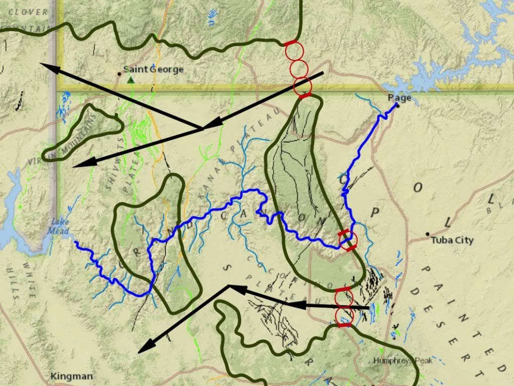
At some point the flood water was above all these features, while today it is below these features. This means that at some time flood water was at the elevation of all these features as the levels went down. At some point the flood level would be at the 7000 ft topo line, and either (a) the erosion at these two paths was occurring or (b) it had occurred, and either way there would be evidence of active erosion in these two locations. The circles show the widths of 3 paths ...
Scaling from the topo map I get a rough diameter for those circles at ~6.5 miles, or 34,320 ft, so two would be 68,640 ft wide and three would be 102,960 ft wide ... and assuming a triangular cross-section for comparison:
So at the point when the flood filled up to the 7,000 ft topo elevation the path to the south would have ~37% of the capacity of the fully carved canyon, which would still be a substantial erosive force ... and yet there is no canyon there, there is no evidence of an erosion channel across this path at all. And the path to the north would have 111% of the capacity of the fully carved canyon, more than the canyon, and yet ... and yet there is no canyon there, there is no evidence of an erosion channel across this path at all. Why?  Edited by RAZD, : why Edited by RAZD, : piclinkby our ability to understand Rebel☮American☆Zen☯Deist ... to learn ... to think ... to live ... to laugh ... to share. Join the effort to solve medical problems, AIDS/HIV, Cancer and more with Team EvC! (click)
|
|||||||||||||||||||||||||||||||||
|
Percy Member Posts: 22479 From: New Hampshire Joined: Member Rating: 4.7 |
Faith writes: I HAVEN'T EVEN READ THIS STUPID POST OF YOURS, MAYBE LATER. DON'T NEED THE ULCER FROM THE STUPIDITY YOU ARE IMPUTING TO ME WHICH IS YOUR OWN. Well, you must have read part of my stupid post because you respond with this misunderstanding:
HERE IS THAT CROSS SECTION AGAIN BY THE WAY. LOOK AT THE ALTITUDE LEVELS AT THE SIDE, IT'S ALL ABOVE SEA LEVEL. THE ONLY PART THAT GOES AT ALL BELOW SEA LEVEL IS THE FAR NORTH END OF THE LOWEST STRATA OF THE GRAND STAIRCASE. The current elevation of the canyon floor is 2200 feet above sea level. If the catastrophic flow of water that created the Grand Canyon occurred before the uplift, then since the top of the canyon was 2 miles above this level just after the flood (the 1 mile of sedimentary layers up to the current canyon rim plus the 1 mile of additional sedimentary layers that is your estimate of what was also there just after the flood), it would have had to have been 2 miles lower just after the flood in order to avoid having to flow uphill. That means that what is now the canyon floor must have been around 8400 feet below sea level just after the flood. This means your catastrophic flow of water must have eroded down 8400 feet below sea level. On the other hand, if the catastrophic flow of water occurred after the uplift, then it flowed uphill. Take your pick: the catastrophic flow of water carved down 8400 feet below sea level, or it flowed uphill. An aside: at some point you have to take some responsibility for the stupid things you say. They can't all be someone else's fault. We're just following a few hundred years of geological research and doing simple math. You, on the other hand, are just making things up. --Percy
|
|||||||||||||||||||||||||||||||||
|
RAZD Member (Idle past 1425 days) Posts: 20714 From: the other end of the sidewalk Joined: |
There is no range given in the second table, it gives the same angle for wet and for dry, not a range. Wet but not submerged. There is a big difference in behavior because of the effect of surface tension in the water holding the sand in place. Underwater this effect is gone and with dry sand it is gone.
No, when deposited by flood water you need to apply the submerged angle of repose. I'm still wondering about this. ... How can it not be underwater when deposited by a flood.
... The paper includes tables comparing angle of repose for sand stacked in air, stacked in air and then submerged, stacked under water, and stacked in air damp. ... Which applies to those conditions if they remain that way.
... . I'd be curious if the angle stays the same as you claim it does when the sand that was wet in any of these scenarios is left alone to dry out. Curiously, that is not what I have said. If you take a stack made when moist -- 45° -- and let it dry out, as the surface dries out it will slump or slide down and when the stack is fully dry the outer shape should be at the dry sand angle of repose -- 34° If you take a stack made underwater -- <30° -- and dry it out it will remain at that angle of repose (or any other angle below the dry sand angle of repose) Do you know why the angle of repose for submerged sand is always lower than the angle of repose for dry sand? I'll give you a hint: the angle of repose is different for different materials because of
Fill in the blanks.  by our ability to understand Rebel American Zen Deist ... to learn ... to think ... to live ... to laugh ... to share. Join the effort to solve medical problems, AIDS/HIV, Cancer and more with Team EvC! (click)
|
|||||||||||||||||||||||||||||||||
|
Atheos canadensis Member (Idle past 3018 days)  Posts: 141 Joined:
|
You can "explain" anything if you don't mind violating the laws of nature, something geologists seem to commit at least as often as they accuse creationists of committing it Now hang on, Faith. You're doing that double standard thing again. Here you are making a big deal about violating the laws of nature, but when I point out to you that it requires a violation of natural law to say the meanders of the GC were caused by the Flood or that an in situ brooding dinosaur was buried by the Flood, you declare it irrelevant. Seems a bit sketchy. Why is violating physics only a problem when you think others are doing it?
|
|||||||||||||||||||||||||||||||||
|
Dr Adequate Member (Idle past 304 days)  Posts: 16113 Joined: |
SOME people on the thread have said HOW water sorts things, OTHERS have said it doesn't sort things, period. If you will quote the things you have mistakenly taken to be contradictory, I shall undertake to explain them to you.
|
|||||||||||||||||||||||||||||||||
|
Atheos canadensis Member (Idle past 3018 days) Posts: 141 Joined: |
SO WHERE ARE YOU, ATHEOS? YOUR CONTENTION HAS BEEN SHOWN TO BE WRONG, OR AT LEAST INCONCLUSIVE. Oh hi there Faith. Sorry, I have been traveling over the holidays or I would have answered your overconfident bellow sooner. Not that I see the point. It has already been pointed out to you that the information you highlight here doesn't actually change the point I made. Note that the angle of repose (AoR) for dry sand is different from the AoR for submerged sand, i.e. sand that is deposited underwater. Even this chart you have posted says that dry sand has a different AoR than submerged sand. I apologize for the confusion I may have caused by imprecisely referring to submerged sand as wet sand. But now it's all cleared up and you're back where you started. Except now you have acknowledged the issue and it will be embarrassing if you decide you don't want to talk about it again. This quote is fairly revealing:
I wasn't going to pursue this topic at all but then I looked up a few things and found that paper, This makes it rather obvious that the reason you had no intention of pursuing this topic was that you had no counterargument to present. Now that you have mistakenly concluded that this chart supports your position you have suddenly become interested again. But now that it has been pointed out that the chart still doesn't say that submerged sand and dry sand have the same AoR, I suspect you will "lose interest" again. I'm guessing that, despite the fact that you are once again discussing what you originally declared to be irrelevant, you will not be interested in providing an explanation for that brooding dinosaur. It seems that things are only relevant when you think (however misguidedly) that you have a good explanation for them. Prove this impression wrong by actually trying to refute my point about the brooding dinosaur.
|
|||||||||||||||||||||||||||||||||
|
Faith Suspended Member (Idle past 1464 days) Posts: 35298 From: Nevada, USA Joined: |
According to this site on Grand Canyon geology
At its greatest hieght the Colorado Plateau was once about three miles above sea level. The rise of the plateau probably prevented the seas from submerging it again and instead the topmost layers were eroded away and carried into the sea. When it was three miles above sea level, over two miles of its height was the strata up to the level of the Claron in the Grand Staircase to the north. If you look at that cross section you'll see all the cracks in that area. Just figure they also occurred in the Grand Canyon area. In the GS area water eroded away the steps, leaving the cliffs; in the GC area it eroded away all the strata above the Kaibab with the exception of one little butte to the south, and cut the canyon. Right at the end of the rise of the Flood water, the uppermost level of the newly laid-down strata, a mile above the level of the current rim, was FLAT and extended for thousands of square miles, and Flood water standing above it, or the huge lake that is the other explanation, would have been higher than its level and when the uplift began and cracked it the water would have been there to run into the cracks. The bottom of the cracks would always be lower than the level of the water and as it deepened more water would rush in, collapsing the strata on both sides and continuing to widen and deepen it. The cross section shows the lowest strata to the north to be below sea level. Before the uplift that was probably also the level of the lowest strata in the Grand Canyon area, which means the current level of the river which Percy keeps going on about would have been a thousand or two feet below sea level, not over eight thousand or thirteen thousand below sea level, and at no point was the canyon CUT that deep in any case. There was no canyon or river at that point, at the end of the rise of the Flood waters, just strata. Then after the strata were all in place to their greatest height the area was uplifted and the canyon started to be cut into the uppermost strata a couple miles above it and all those upper strata eroded away, leaving only some of them in the Grand Staircase area. When the canyon was finally cut all the way down to the current level of the river that level was well above sea level as is shown on the cross section. The catastrophic flow of water did NOT occur before the uplift, that's impossible and I've certainly never said such a thing. The uplift CAUSED the catastrophic flow. First it caused the cracking in the uppermost strata, THEN the water flowed into the cracks. And again, there's no way I can think of that a mere river could have found its way into the track that finally became the GC, but a catastrophic flow of water that originated above the level of the uppermost strata COULD do just that. And just to keep the reference active, here's that cross section again. Note how the Grand Staircase has CRACKS in it, the canyons and cliffs having been formed by them. Also check out the altitudes of various parts of the formations with the levels given along the sides:
Edited by Faith, : No reason given. Edited by Faith, : No reason given. Edited by Faith, : No reason given. Edited by Faith, : No reason given. Edited by Faith, : No reason given. Edited by Faith, : No reason given. Edited by Faith, : No reason given. Edited by Faith, : No reason given.
|
|||||||||||||||||||||||||||||||||
|
Faith Suspended Member (Idle past 1464 days) Posts: 35298 From: Nevada, USA Joined: |
Submerged sand has a lower, not a higher, angle of repose, as you had claimed (not that it matters I suppose, but since you were being so aggressive about challenging me with it you ought to be more up on these things).
I want to know why you think that if it was deposited under water the angle of repose would have remained the same after it dried out. Dry sand has a different angle of repose, even "wet" sand does according to those tables, and it's the same as for dry sand. So, apparently the angle of the crossbedding seen in the sandstone strata is the same as the angle of repose, yes?, which is therefore the angle of repose of either the dry OR the "wet" sand as reported in those tables. The question remains: If the sand was submerged, deposited in the Flood waters, why should it continue to retain the angle of repose of submerged sand after it has dried out, or even after it has dried to the point of being described as "wet," since it is the water content or lack of it that determines the angle? Seems to me this COULD be determined by a kitchen table test of the sort Coragyps has proposed I could do with the kit he's offered to send. Edited by Faith, : No reason given. Edited by Faith, : No reason given. Edited by Faith, : No reason given. Edited by Faith, : No reason given. Edited by Faith, : No reason given.
|
|||||||||||||||||||||||||||||||||
|
Faith Suspended Member (Idle past 1464 days) Posts: 35298 From: Nevada, USA Joined: |
Have to check on some things before I post this.
Edited by Faith, : No reason given.
|
|||||||||||||||||||||||||||||||||
|
RAZD Member (Idle past 1425 days) Posts: 20714 From: the other end of the sidewalk Joined: |
I want to know why you think that if it was deposited under water the angle of repose would have remained the same after it dried out. Dry sand has a different angle of repose, even "wet" sand does according to those tables, and it's the same as for dry sand. The question remains: If the sand was submerged, deposited in the Flood waters, why should it continue to retain the angle of repose of submerged sand after it has dried out, or even after it has dried to the point of being described as "wet," since it is the water content or lack of it that determines the angle? The angle of repose is the maximum angle a slope of material can stand at -- but it can always be a flatter angle, even (gosh) horizontal ... Once deposited and covered by an additional layer there is no mechanism to change the angled layer orientation inside the formation. Sand does not move when it feels like it Faith -- there has to be something pushing it. Curiously, you have already been told this: what is hard to understand about the concept that once deposited and covered the sedimentary structure doesn't shift, doesn't move, doesn't rotate without a cause, a force, a mechanism.
So, apparently the angle of the crossbedding seen in the sandstone strata is the same as the angle of repose, yes?, ... For dry sand, yes.
... which is therefore the angle of repose of either the dry OR the "wet" sand as reported in those tables. No, because "wet" sand does not cross-bed. The only way cross bedding occurs is when the particles are carried by an erosive agent (air or water for instance) and then deposited when the energy\velocity of the agent drops to the point it can no longer carry the particles -- as when wind or current goes over the top of a dune (dry) or sandbar (submerged). The "wet" and "moist" conditions hold the sand particles with surface tension. Underwater the "wet" and "moist" conditions would be quickly dissipated by water currents into "submerged" conditions. On land any wind that could blow particles out of "wet" or "moist" conditions would also dry it.
Seems to me this COULD be determined by a kitchen table test of the sort Coragyps has proposed I could do with the kit he's offered to send. Indeed. The testing mechanism is fairly simple to make and use.
Submerged sand has a lower, not a higher, angle of repose, ... Indeed. Do you know why the angle of repose for submerged sand is always lower than the angle of repose for dry sand? I'll give you a hint: the angle of repose is different for different materials because of
Fill in the blanks. Edited by RAZD, : clrtyby our ability to understand Rebel American Zen Deist ... to learn ... to think ... to live ... to laugh ... to share. Join the effort to solve medical problems, AIDS/HIV, Cancer and more with Team EvC! (click)
|
|||||||||||||||||||||||||||||||||
|
Faith Suspended Member (Idle past 1464 days) Posts: 35298 From: Nevada, USA Joined: |
Once deposited and covered by an additional layer there is no mechanism to change the angled layer orientation inside the formation. Sand does not move when it feels like it Faith -- there has to be something pushing it. Nothing "pushes" it into the angle of repose, it just falls there. I understand it would have to have room to fall, but I would still like to see an experiment or ten done to prove your claim, or disprove it.
Curiously, you have already been told this: what is hard to understand about the concept that once deposited and covered the sedimentary structure doesn't shift, doesn't move, doesn't rotate without a cause, a force, a mechanism. There's no problem understanding this, it's intuitively graspable, but once it became clear to me that it's not some intrinsic shape of the grains but merely their dryness or wetness that causes them to arrange themselves according to one angle of repose or another it simply raises the question in my mind whether a change in dryness or wetness would change the angle, and it seems it should. Some of the tables in that paper report on experiments with changing the conditions of a stack such as stacking sand in air and then submerging it, so they have some idea that it should change its angle and apparently it does though maybe not to the extent one might expect. I'd like to see experiments done that go from wet to dry rather than just dry to wet. [By the way, I may have "already been told" countless things here, but you should know that if a post is insulting or accusatory pr a straw man argument or repetitive or doesn't deal with the issue on my mind at the moment, since this is a huge thread and I get stuff from at least half a dozen people, I simply don't read a lot of it. So you may "already have said" lots of things that simply didn't get to me. I don't see how that can be avoided on a huge thread like this. I don't WANT to read a lot of the stuff I get especially if it's irrelevant to my own concerns, it's too much to ask of me. I read what I want to read.] So, apparently the angle of the crossbedding seen in the sandstone strata is the same as the angle of repose, yes?, ...
For dry sand, yes. ... which is therefore the angle of repose of either the dry OR the "wet" sand as reported in those tables.
No, because "wet" sand does not cross-bed. How odd, it assumes an angle of repose but it doesn't cross-bed, though dry sand does, at ITS angle of repose. How odd. Can you give a reference for this?
The only way cross bedding occurs is when the particles are carried by an erosive agent (air or water for instance) and then deposited when the energy\velocity of the agent drops to the point it can no longer carry the particles -- as when wind or current goes over the top of a dune (dry) or sandbar (submerged). The "wet" and "moist" conditions hold the sand particles with surface tension. So it doesn't just fall into that form although it does just fall into its angle of repose. So you would assume that the formation in northeast Arizona called The Wave, which is made up of that amazing swirly sandstone with crossbedding, wasn't formed in water as I would assume it was, if only because I can't figure out how dry sand in such shapes could lithify.
Underwater the "wet" and "moist" conditions would be quickly dissipated by water currents into "submerged" conditions. Yeah yeah yeah but I'm asking about going FROM submerged conditions to "wet" or "dry" conditions.
On land any wind that could blow particles out of "wet" or "moist" conditions would also dry it. I'm thinking of the condition of its being originally submerged and then the water running out of it leaving it damp or "wet" or even eventually dry.
Seems to me this COULD be determined by a kitchen table test of the sort Coragyps has proposed I could do with the kit he's offered to send.
Indeed. The testing mechanism is fairly simple to make and use. Maybe I'll take him up on his offer. A quart of sand, a pyrex dish etc. Or if I can find a source of different kinds of sand I could set it up myself. Edited by Faith, : No reason given. Edited by Faith, : No reason given.
|
|||||||||||||||||||||||||||||||||
|
|
Do Nothing Button
Copyright 2001-2023 by EvC Forum, All Rights Reserved
![]() ™ Version 4.2
™ Version 4.2
Innovative software from Qwixotic © 2024


 (1)
(1)