|

Understanding through Discussion |
|
|
Register | Sign In |
|
QuickSearch
| EvC Forum active members: 63 (9162 total) |
|
| |
| popoi | |
| Total: 916,385 Year: 3,642/9,624 Month: 513/974 Week: 126/276 Day: 23/31 Hour: 0/0 |
Summations Only | Thread ▼ Details |
|
Thread Info
|
|
|
| Author | Topic: Why the Flood Never Happened | |||||||||||||||||||||||||||||||||||||||||||
|
herebedragons Member (Idle past 877 days)  Posts: 1517 From: Michigan Joined: |
Well, you're a true child of this forum, HBD, defying gravity with aplomb. :facepalm: I really don't know what to say... are you being serious that you don't get this?? I am beginning to wonder if you really don't even believe what you are saying but are simply disagreeing just to disagree. But I guess I will have to take you at face value and assume you really don't get it. I made a sketch of what I am talking about below.
The flow rate is a given because it depends on all the source water from upstream. The width is constrained by the stream banks (the uplift will also lift the banks as well as the bottom). The only variable is the velocity. Of course this is a simplified illustration, but it is the basic principals involved. Faith, this is elementary physics. If you can't get this why should I take anything you say seriously? HBDWhoever calls me ignorant shares my own opinion. Sorrowfully and tacitly I recognize my ignorance, when I consider how much I lack of what my mind in its craving for knowledge is sighing for. But until the end of the present exile has come and terminated this our imperfection by which "we know in part," I console myself with the consideration that this belongs to our common nature. - Francesco Petrarca "Nothing is easier than to persuade people who want to be persuaded and already believe." - another Petrarca gem.
|
|||||||||||||||||||||||||||||||||||||||||||
Faith  Suspended Member (Idle past 1464 days)  Posts: 35298 From: Nevada, USA Joined: |
This doesn't work. With the Grand Canyon region uplifted a mile or more above river level, were the cracks only through the uppermost layers of the uplifted region then the river would have no way to attain that height. It isn't off the wall. Simply replace "river" with your "catastrophic flow" that comes from a lake. With the Grand Canyon region uplifted a mile above the surrounding region, how is your catastrophic flow going to climb up into any cracks. It is not. It's going to flow around. I don't think the uplift is a mile high, just a few thousand feet, although that's high enough now that I see the scenario you have in mind. But this is what makes the lake a better explanation than standing Flood waters, which WOULD drain away around the uplift (although I considered that they could be high enough to cover even the uplift or that the upper strata broke up soon enough to catch the Flood water in the process of the land's rising). But probably the better scenario IS the lake, the lake area also being uplifted on the same plateau. And then because of the disturbance of the uplift itself, spilling into the VERY BIG cracks along the south slope of the uplift.
So I picture these cracks opening up beneath a certain depth of Flood waters so that as they start to drain away some of it finds its way into these cracks in the mounded uppermost strata, breaking off pieces and widening the cracks as it goes.
This is not the scenario I've been addressing. I've been talking about your catastrophic flow. This is NOT a meaningful distinction based on anything I myself have said. I've consistently said the water that would have carved the canyon, that YOU keep calling "the catastrophic flow" would have been produced by EITHER the standing Flood waters as described here OR the lake as described above.
I DO understand about slope retreat, from the erosion of the canyon walls since the canyon was cut, I simply do not believe it is enough to explain the enormous width of the canyon in places, and I do not believe the slope formation needed any more than a few thousand years to develop. Yes, I assume the cut-through would have been vertical, and THEN the walls would have eroded to their present cliffs and slopes. I have never NOT understood this. Again, I do not believe the slope formation needed any more than a few thousand years to develop.
Faith, one of the signs we've become familiar with over the years is that when you're finally forced to object that you do *too* understand something, it means you don't understand it. You didn't understand a waterfall cutting upstream, and you don't seem to understand slope retreat. I also never COMMENTED on anything related to the waterfall cutting upstream or CLAIMED to understand anything concerning it which makes this utterly false. It was a brand new idea to me with that animated graphic in the video. Perhaps you think you described it earlier but nothing even REMOTELY like that graphic was ever said THAT I RECALL, even for me to have misunderstood.
An angled slope in a canyon can only mean that the canyon sides were exposed gradually over a long period of time. That is absolute nonsense. The angled sides were caused by EROSION after having been cut vertically.
If it takes a certain rock layer in the sides of a canyon a thousand years to erode back a foot, and if the angle of the slope of the canyon side at this point is 45 degrees, then it must also have taken the river a thousand years to erode down a foot. The more mild the slope of the canyon walls, the longer it took the river to erode down. What ARE you talking about? The erosion of the WALLS of the canyon has absolutely NOTHING TO DO with the river. Assuming the river was ever big enough to cut the walls, which it would have been had it been a stage of the Flood waters, it would nevertheless not have cut the angles, those were caused by erosion AFTER the river had become a normal river.
On the other hand, if the slope of the canyon wall is very steep or vertical, then it took the river very little time to erode through the rock layers. You are talking gibberish at this point. The steep walls are in the hard rock, the slopes are the eroded material that has collected beneath the eroded areas, on top of other layers or at the very bottom.
Here's a view of part of the Grand Canyon. You say the canyon was eroded quickly, which means vertical sides, but that's not what we see here: BUT THE CANYON HAS BEEN ERODING BY NORMAL YEARLY MEANS SINCE IT WAS CUT, pieces falling off, sometimes big pieces, sometimes small ones, some of it getting into the river and being carried downstream, some of it forming the slopes. THIS HAS BEEN GOING ON FOR MORE THAN FOUR THOUSAND YEARS SINCE IT WAS CUT. THAT is what accounts for the shelves and slopes. GOOD GRIEF this is ridiculous. It may also be wrong to assume the walls were straight up from bottom to top when cut too, as the water could have cut back the uppermost rock farther than lower rock. But then you'd have tiers of completely vertical rocks anyway. Yes it had to start out VERTICAL, either as one wall or in tiers of vertical rocks. BUT THE SLOPES ARE THE RESULT OF YEARLY EROSION SINCE THEN. Stop imputing such idiotic nonsense to me. And stop claiming ANYTHING about what I know or don't know. You haven't yet been right about any of it.
How do you explain that the sides aren't vertical without invoking things about the natural world that simply aren't true, like your idea that the rocks of the canyon were still wet and soft so they could be easily eroded yet somehow didn't get extruded into the canyon (especially at the base with a mile of layers pressing down from above), and then somehow harden into real rock, even the topmost layers that have no overlying layers providing the necessary rock-forming compression. I believe that mere compaction from the weight of the sediments was sufficient to stabilize the strata so that they wouldn't slump when cut. You haven't proved otherwise, you just assert it like everybody else here does as if your own imagination had some special revelatory status. The uppermost strata were compacted sufficiently from more than a mile of strata above them by the time they were cut so that the uppermost layers were also quite solid, the Kaibab limestone being particularly solid which is why its surface remained while the strata above eroded away. I have thought about all this and your imagination has shown itself to be so ridiculously faulty that alone discredits your objections.
The very obvious explanation for the sloping Grand Canyon walls is that the erosion was gradual, providing the necessary great amount of time for slope retreat. What I already described is quite valid. The slope retreat visible in the picture would not have taken more than 4300 years of normal yearly erosion after the walls were cut. That's a LOT of time, no millions of years are EVER needed for the phenomena we can see on this earth as Old Earthers keep imagining. I'm sure you can collect a whole battalion of Old Earthers to confirm your nonsensical misunderstandings of course. Edited by Faith, : No reason given. Edited by Faith, : No reason given.
|
|||||||||||||||||||||||||||||||||||||||||||
|
Atheos canadensis Member (Idle past 3018 days)  Posts: 141 Joined:
|
Okay Faith, it seems very straightforward to me so perhaps I am misinterpreting your position at some stage. Allow me to explicitly state my assumptions about your position.
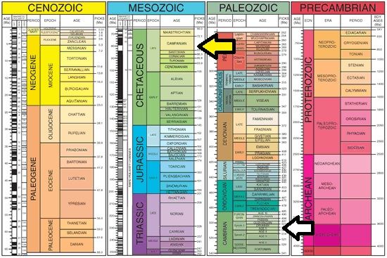
1. You believe that the entire rock record (or maybe just everything from the Paleozoic onward) is the product of the Flood. Is this correct? If not, what portion of the rock record do you consider to be the product of the Flood? 2. You understand that the deposit is terrestrial. I made this assumption because you already conceded this point: Message 806. If you've forgotten why, it's because the brooding dinosaur is a terrestrial dinosaur sitting undisturbed on its nest (Message 743). Therefore it could not have been deposited in an aqueous environment; it would have had to have been transported. 3. Knowing that the dinosaur was deposited in a terrestrial environment, you think that it must have been buried in the early stages of the Flood (Message 746). Okay, do I have that right? Please point out any errors. So anyway, this is where superposition becomes a problem for you. You accept the dinosaur was deposited in a terrestrial environment (or at least you did) so it must have been buried in the early stages of the flood, "before the water level was that high" as you say. If the various strata in the rock record were deposited by the Flood then the strata appearing at the bottom of the record should be those deposited by the earliest stages of the Flood in accordance with the law of superposition. Still make sense? Older stuff gets deposited first. The problem is that the brooding dinosaur is not near the bottom of the rock record. Let's visualize it:
The brooding dinosaur should (having been buried near the start of the Flood) appear near the base of the record, indicated by the white arrow (Note: I have conservatively placed the arrow at the base of the Paleozoic rather than the Precambrian. If you think the entire rock record is the product of the Flood then it should be at the base of the Precambrian). The yellow arrow indicates where it actually appears, not at all near the bottom of the record. Given that the brooding dinosaur is an in situ terrestrial deposit, it only fits into your model if it was buried near the start of the Flood. But its position nearer the top means it can't have been deposited at the start of the Flood unless it violates the law of superposition. It makes perfect sense from the conventional view however.
|
|||||||||||||||||||||||||||||||||||||||||||
|
Faith Suspended Member (Idle past 1464 days) Posts: 35298 From: Nevada, USA Joined: |
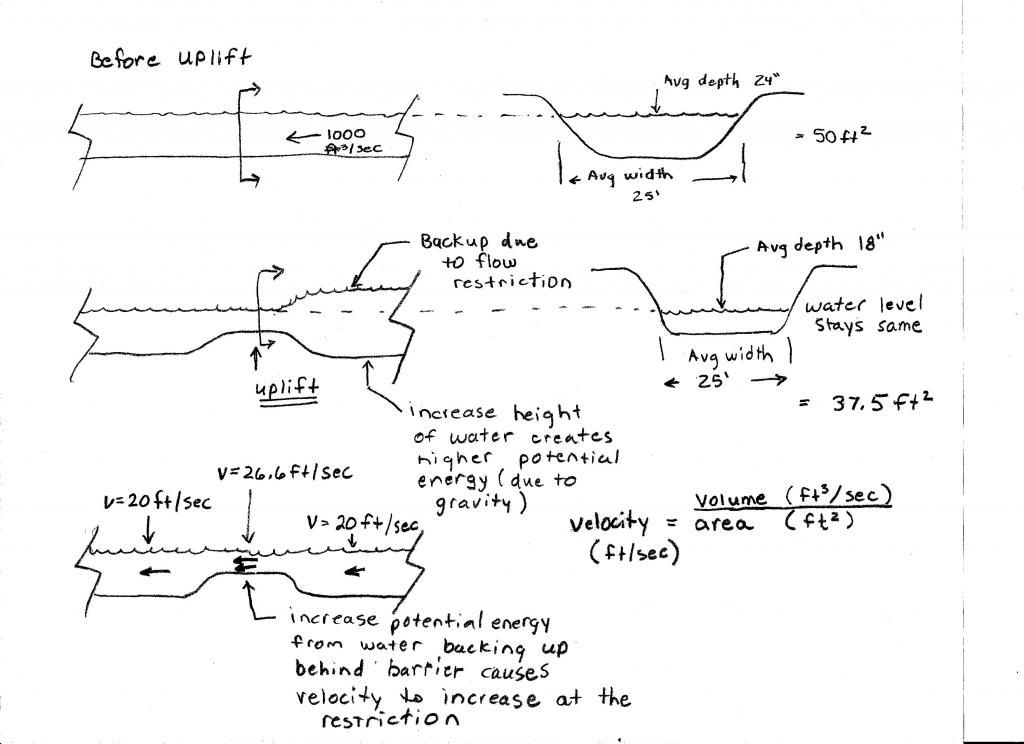
If your illustration represents what you thought you were talking about I'm amazed. You said nothing about the barrier backing up the water and increasing the volume upstream, I'm the one who brought all that up. It seems that WOULD increase the velocity over the uplift, but it would first increase the depth of the water passing over it (since it's increased the depth and volume of the upstream water) so I'm not sure about your velocity formula yet. For sure there's a raised level of the water going over the uplift, which you don't illustrate, which is caused by the backup, but that just increases the possibility of the upstream river's jumping its banks it seems to me.
Well I've been pondering it a while and have to give up for now. Would it really increase the velocity sufficiently to offset its overflowing its banks behind the barrier? Would it really erode down far enough to level it with the former riverbed and deepen the banks on the uplift? etc etc etc. It seems a very odd way to run a river but I have to think about it some more.
|
|||||||||||||||||||||||||||||||||||||||||||
|
herebedragons Member (Idle past 877 days) Posts: 1517 From: Michigan Joined: |
If your illustration represents what you thought you were talking about I'm amazed. You said nothing about the barrier backing up the water and increasing the volume upstream, I'm the one who brought all that up. Well, it wouldn't actually raise the water level, because the water will be trying to find the lowest level possible. I drew it backing up to show you where the energy would come from to push the water through the uplifted section at a higher velocity.
For sure there's a raised level of the water going over the uplift, Somewhat yes. It would depend on how much resistance to flow there is in that area such as rocks or vegetation. The water will want to reach the optimum velocity of 26.6 ft / sec (at the uplift in my illustration) but if there is resistance, it may swell up somewhat, but the upper surface of the water will remain relatively flat.
I'm not sure about your velocity formula yet. Very basic formula. There would be other factors that would come into play such as texture of the river bottom, debris etc. but this is a basic flow calculation. You could rearrange it to say "volume = area * velocity" if that makes more sense.
Would it really increase the velocity sufficiently to offset its overflowing its banks behind the barrier? Would it really erode down far enough to level it with the former riverbed and deepen the banks on the uplift? etc etc etc. It seems a very odd way to run a river It really wouldn't increase the volume of water behind the barrier since the water would constantly be forcing itself through barrier. The upper surface of the water would remain relatively flat. Just visit a local stream sometime. That's exactly how it works. Rapids would be areas of fast moving shallow water (very high energy), which would be followed by a deeper area called a pool where water would be slower moving (lower energy).
but I have to think about it some more I am trying to be patient and understanding and I try to be respectful of your beliefs, but if you have to ponder on very basic matters such as this one, then maybe its time to slow down and go back and learn the basics before trying to tackle the big issues. Maybe a lot of these "misunderstandings" would be cleared up if you could grasp the fundamentals of physics and geology. I really am not meaning this as a personal attack or a slam against you. But that's where so much of the difficulties are coming from in this debate. See, I don't believe that water flows faster through a shallower channel because I believe in an old earth. I am not skeptical that the entire geological column could be scoured up, laid down, eroded and then lithified in less than a year because I have been indoctrinated by old earth philosophies - I have those opinions because I can understand the basics which can then be applied to the more complex problems. It seems to me that you are so intent on proving a young earth and disproving an old earth that you have skipped that valuable step of learning the basics. So much of science can be learned in a totally age neutral way. There is no need to say anything about old earth/young earth when learning about how rivers cut through the landscape. I even tried to show you how the geological column can be age neutral. Again, I am not trying to belittle you, but basic scientific principals seem to elude you. It may be time to redirect your energy into developing a better understanding of the basics. I think you will be less frustrated too. HBDWhoever calls me ignorant shares my own opinion. Sorrowfully and tacitly I recognize my ignorance, when I consider how much I lack of what my mind in its craving for knowledge is sighing for. But until the end of the present exile has come and terminated this our imperfection by which "we know in part," I console myself with the consideration that this belongs to our common nature. - Francesco Petrarca "Nothing is easier than to persuade people who want to be persuaded and already believe." - another Petrarca gem.
|
|||||||||||||||||||||||||||||||||||||||||||
|
Percy Member  Posts: 22479 From: New Hampshire Joined: Member Rating: 4.7 |
Faith writes: I don't think the uplift is a mile high, just a few thousand feet, although that's high enough now that I see the scenario you have in mind. I was trying to describe the scenario *you* had in mind. It would make no sense to ask you to defend some other scenario. I do often find myself trying to call to your attention to implications of your scenario that you seem not to have noticed, but my intention is to always focus on *your* scenario. I didn't say the Grand Canyon region uplifted a mile. I don't know exactly how much the uplift was. I said the uplift took it a mile above what is now river level. It's just a simple fact since the Grand Canyon is about a mile deep. So let's go with your figure of a few thousand feet of uplift, call it 3000 feet. So the Grand Canyon region is 3000 feet higher than the surrounding region, and the cracks are in the topmost layers, let's say cutting down 1000 feet. The bottom of the cracks are 2000 feet above the surrounding region. How does this catastrophic flow from the lake climb that 2000 feet? Let's also recall that your scenario has an additional mile worth of layers (like the Claron layer and so forth) above what is now the top of the Grand Canyon that were subsequently eroded away. If this catastrophic flow couldn't overtop the uplifted Grand Canyon region, then it couldn't have eroded away this mile of layers. Now I assume your scenario holds that the receding flood waters eroded away this mile of strata, but that's not possible. Receding water creates no strong flows that could do that. To prove this to yourself, pile up several shovel fulls of dirt in the middle of your bathtub, fill your bathtub with water, then pull the plug. The pile of dirt will not be much affected by filling and draining the bathtub. Certainly you won't find the draining water eroding off any significant amount of dirt from the top of the pile. You seem to understand this already because you go on to say:
But this is what makes the lake a better explanation than standing Flood waters,... I agree (though it's only a matter of focusing on the less ridiculous), and that's why I've been focusing on your lake scenario.
But probably the better scenario IS the lake, the lake area also being uplifted on the same plateau. Well, this is new. The lake region was uplifted too? You know, if the lake bottom was the same height as the Grand Canyon region then it would have needed sides much higher than the Grand Canyon region to hold the considerable amount of water required to cut the canyon. Where are the sides now? And then the lake region must have experienced subsidence to its current elevation. The lake scenario has other serious problems that I've mentioned before. The Grand Canyon isn't the only place where the Colorado River has carved canyons, it is merely the most spectacular. If you follow the course of the Colorado up river into Utah and then Colorado you find that it has carved canyons everywhere. You need your lake to be atop the Rockies.
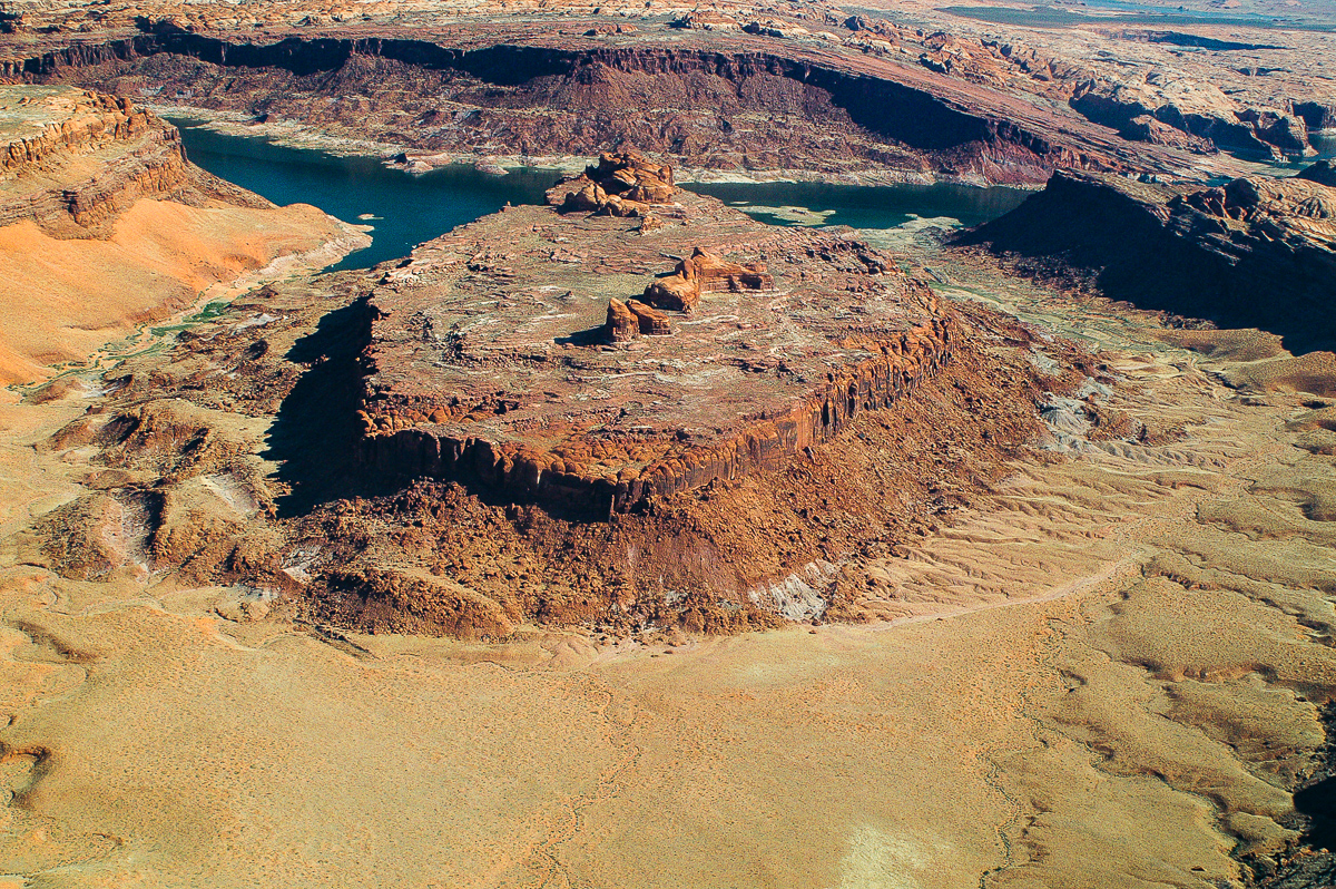
I've consistently said the water that would have carved the canyon, that YOU keep calling "the catastrophic flow" would have been produced by EITHER the standing Flood waters as described here OR the lake as described above. A catastrophic flow could occur from the bursting of a dammed lake, but not from diminishing water levels as the flood ends. I refer you back to the bathtub experiment. It will help you understand how flooded landscapes really behave. About slope retreat, as I've commented before, you have very little feel or intuition or understanding for how the world really works. The sides of a rapidly formed canyon will be vertical, and they will remain vertical once exposed to erosion by weathering. Where softer layers overlay harder layers you might get shelves since the softer layers will erode back more quickly than harder layers. And where harder layers overlay softer layers they will retreat as quickly as the softer layers because where the softer layers erode away the above harder layers will lose their support and eventually the strain will cause breakage and they'll collapse into the canyon. But in both these cases the sides of the canyon will remain vertical. The same lack of understanding about how simple physical processes work is also showing itself in your discussion with HBD about how gradual uplift affects the flow of a river. We had this discussion earlier in the thread, and you didn't understand this then either. I hope his diagram helps. You somehow completely missed the sloping sides of the Grand Canyon in this image:
Yes, the gray material sloping down to the river is scree. Scree isn't canyon sides. Your were supposed to be looking at the sides of the canyon, not the scree. Let your eyes follow the scree upward to higher levels of the canyon, on both the left and right sides of the river. See the sloping sides, especially on the left in the foreground. Also look at the slopes on the right side of the river in the far distance. Slope retreat of miles through solid rock takes millions of years, and the sloping sides of the canyon are a record of how long it took for the river to erode down through those layers. --Percy
|
|||||||||||||||||||||||||||||||||||||||||||
|
shalamabobbi Member (Idle past 2869 days)  Posts: 397 Joined:
|
Following this thread reminds me of Abbott and Costello's
Who's on first.Who's on First? by Abbott and Costello Do I know exactly how the Flood did the layering, of course not, but I do know that water DOES layer sediments and that the Old Earth scenario that attaches a time period of millions of years to a particular sediment is idiotic. Slowly, the forces of nature are wearing the mountains down from the summits, and filling in the lakes from their stream entrances outwards. This implies a natural preference for flat terrain. If everything stayed consistent for all time, the world would be a rather flat and uninteresting place. However, thanks to constantly changing climates and large scale geological movements, like mountain building, we are treated to unending diversity. As nature slowly sculpts the landscape and works to flatten it, occasionally rapid (geologically), large scale disruptions, like the uplifting of mountains, force it to begin anew. What a ROMANTIC piece of nonsense, even "religious" in tone I must say. Personally I think it's remarkable that the planet is as accommodating to human interests as it is, as beautiful as it is, in spite of its basically wrecked condition. Anyway, I think the idea that mountains would erode to flatness is absurd. "A natural preference for flat terrain" is very much romantic nonsense. See, this is what comes of a science that operates entirely on imagination because there is no way to test or check it. In my experience erosion forms gashes and gullies, not flat terrain, water cuts into land etc, and what happened to all that tectonic activity on this "very active" planet, which the video itself started out invoking? Just sort of suspended operations while the mountains collapsed, eh? Over what is it, 500 million years or something like that? Remember your repeated charge that you thought EvC members were forgetting gravity? What else can erosion accomplish besides leveling the planet? "Water cuts into land." Yes and where does that soil that is cut away go? To a lower spot. And what happens to that lower spot? It rises up. Then overall what has occurred? The planet is more level than before.
So at the bottom of the *flood produced* geologic column is the original pristine surface of the earth as it was prior to the flood event? The one that was very much more verdant and tropical than the modern biosphere? Oh no, that's not the idea at all. There's no "bottom" involved, ALL of the geologic column from bottom to top is the evidence of that pre-Flood world, the deposition of all those different sediments in neat horizontal layers, which I think defies any sort of long term explanation but is very compatible with what is known about the behavior of water, then all those fossils of so many forms of life, familiar and unfamiliar, fossils requiring special circumstances to form too but such an abundance of them; and all the fossilized vegetation, some of which has become coal. I think the generally wrecked look of the entire planet is also evidence of the Flood, which is maybe more evident in the desert areas, greenery doing such a nice job of masking it, but I personally think the Earth LOOKS like a wreck, like a great catastrophe must have overwhelmed it. That's what I mean by the evidence being all around us, everywhere we look, but I do think the strata are particularly special evidence of it. Ok, so the earth is torn up and redeposited. But that would have leveled the surface and left the entire planet under water. So now you invoke tectonic activity to raise it back up? Plates crashing into plates as pictured by modern geologists but much faster? Surely you realize that the flood would deposit this load onto the ocean floor as well as onto whatever is left of the continents? And as a side question how does Noah survive such a turbulent event that is so chaotic and energetic that the entire geologic column is floating around in the flood water? The bible seems to describe water levels rising and falling without much mention of the Vitamix blender action you need to move that much soil around.
Well with a hypothetical flood you can generate whatever pressure you like, just by making the flood deeper. Now, THAT is really a misrepresentation of my argument. It wasn't a representation of your argument at all. It was merely an observation of one way a floodist might claim whatever pressure they like. That is all fine as long as the evidence supports the model, whatever it is. Here's a link that will present some more puzzles for you to work on as you put together a model for a global flood that created the geologic column. Good luck.
|
|||||||||||||||||||||||||||||||||||||||||||
|
Percy Member Posts: 22479 From: New Hampshire Joined: Member Rating: 4.7 |
Hi RAZD,
I didn't actually spend too much time analyzing the scenario in that video. I couldn't piece together a coherent narrative using only what they presented, and I'm not sure how much or how accurately the story the scientists were trying to tell was communicated, or even how much they might have agreed with one another. I bet those scientists cringed when they first saw it. Also, there's a lot of disagreement about the age of the canyon, and they didn't even mention that controversy. I did think the video did a good job of illustrating several principles, like the way a waterfall cuts back, and the way erosion levels a landscape (which they screwed up nonetheless by showing the landscape in the foreground erode first with the landscape in the background completely unaffected, the effect of erosion appearing to propagate from foreground to background as if erosion wouldn't have affected all parts of the rugged landscape they showed at the same time - but you tell your animation artists what you want in your best words, and then you get what you get). This is a spectacular image:
RAZD writes:
Incised meanders that are about to be overcut. You can also see the river undercutting the outside curves. Rainbow arch is also there ... It's a fantastic illustration of undercutting at the outside of meanders, which we couldn't see if the river level weren't so low. The normal river level covers the white sides of the canyon, so until the river level lowered those meanders were underwater. I'm guessing the canyon sides are limestone here because of the light color. The reddish color of the upper canyon sides is due to iron in runoff from the surrounding landscape, as can be seen by the vertical reddish streaks in lighter parts of the upper canyon in the distance on the right. It looks like these are recently exposed parts of the canyon sides caused by large portions breaking away, and that the rusty staining is only now beginning, forming vertical streaks where water flows most into the canyon during rainfalls. Notice also how smooth are the formerly submerged portions, more evidence of the sandpaper-like behavior of a sediment laden river like the Colorado. I'm saying these things for general benefit, not because I thought it was stuff you didn't know. I probably missed stuff, please add or correct as necessary. --Percy
|
|||||||||||||||||||||||||||||||||||||||||||
|
herebedragons Member (Idle past 877 days) Posts: 1517 From: Michigan Joined: |
Here's a link that will present some more puzzles for you to work on I watched that video on salt deposits, and I had forgotten that Michigan had one of the largest deposits of salt right under Detroit; 1,200 ft below. The mine was opened in 1910 and closed in 1983. During that time miners removed enough salt to create a 1,500 acre expanse with a 100 miles of roads! And there is still an estimated 71 trillion tons of salt remaining! They reopened in 1998 and produce road salt - something we need a lot of here in Michigan.
Source HBDWhoever calls me ignorant shares my own opinion. Sorrowfully and tacitly I recognize my ignorance, when I consider how much I lack of what my mind in its craving for knowledge is sighing for. But until the end of the present exile has come and terminated this our imperfection by which "we know in part," I console myself with the consideration that this belongs to our common nature. - Francesco Petrarca "Nothing is easier than to persuade people who want to be persuaded and already believe." - another Petrarca gem.
|
|||||||||||||||||||||||||||||||||||||||||||
|
herebedragons Member (Idle past 877 days) Posts: 1517 From: Michigan Joined: |
The normal river level covers the white sides of the canyon, so until the river level lowered those meanders were underwater. I take it this picture is from a location above Glen Canyon Dam, so this would actually be in Lake Powell ?? Wow, it looks like water level is down about 150+ feet! I'm kinda surprised the original channels haven't been completely filled in with sediment. HBDWhoever calls me ignorant shares my own opinion. Sorrowfully and tacitly I recognize my ignorance, when I consider how much I lack of what my mind in its craving for knowledge is sighing for. But until the end of the present exile has come and terminated this our imperfection by which "we know in part," I console myself with the consideration that this belongs to our common nature. - Francesco Petrarca "Nothing is easier than to persuade people who want to be persuaded and already believe." - another Petrarca gem.
|
|||||||||||||||||||||||||||||||||||||||||||
|
Percy Member Posts: 22479 From: New Hampshire Joined: Member Rating: 4.7 |
While poking around for where that image was specifically from I came across this extremely interesting image from the San Juan River (joins the Colorado above Lake Powell):
Obviously no catastrophic flow created these meanders. Looking at the high water mark (top of where the canyon sides are white), I think the broad flat area of that peninsular structure must have been submerged very recently, and I don't mean "recently" as in geological terms, but as in within the past decade or two. But look at how obviously water-eroded are the top surfaces of the higher levels of this landscape. They're either very soft to have been eroded in that way by weathering, or they must have once been river bottom. --Percy
|
|||||||||||||||||||||||||||||||||||||||||||
|
JonF Member (Idle past 188 days) Posts: 6174 Joined: |
Leave us not forget the Goosenecks of the San Juan:
|
|||||||||||||||||||||||||||||||||||||||||||
|
shalamabobbi Member (Idle past 2869 days) Posts: 397 Joined: |
I should have mentioned that after the end credits another video will start. There are seven in all. You can also skip the end credits by clicking on the right for the next segment. They discuss other falsifications of the YEC model. Desert varnish on rocks. Tree rings again. Coprolites. Consilience between radiometric dating of sea floor spreading with molecular clocks of frog species. Two segments on dust from meteor impacts and implications for the YEC model.
All problems for the YEC model. Maybe Faith will explain how these issues will "fall in line."
|
|||||||||||||||||||||||||||||||||||||||||||
|
herebedragons Member (Idle past 877 days) Posts: 1517 From: Michigan Joined: |
I came across this extremely interesting image from the San Juan River It is really hard to get a good perspective of scale in that picture, but those little white specks are boats, so it is an enormous area! I think that is all still part of Lake Powell, so those high water marks could be ~150 feet above water level.
I think the broad flat area of that peninsular structure must have been submerged very recently Probably right, maybe when Lake Powell is all the way full? But Idk, if the white high water mark is 150 above water, then the water level would have to be another 150 feet and Glen Canyon Dam doesn't have that much capacity. Here's an interesting image from a little further upstream on the Colorado but still within Lake Powell. It shows a meander that has been cutoff and is now a meander scar.
But look at how obviously water-eroded are the top surfaces of the higher levels of this landscape. They're either very soft to have been eroded in that way by weathering, or they must have once been river bottom. I noticed this feature in the Grand Canyon too and I have some ideas about it, but I'll have to respond to that later. HBD ABE: original image at Message 1445 Edited by herebedragons, : fixed image/ different image Edited by herebedragons, : No reason given.Whoever calls me ignorant shares my own opinion. Sorrowfully and tacitly I recognize my ignorance, when I consider how much I lack of what my mind in its craving for knowledge is sighing for. But until the end of the present exile has come and terminated this our imperfection by which "we know in part," I console myself with the consideration that this belongs to our common nature. - Francesco Petrarca "Nothing is easier than to persuade people who want to be persuaded and already believe." - another Petrarca gem.
|
|||||||||||||||||||||||||||||||||||||||||||
|
JonF Member (Idle past 188 days) Posts: 6174 Joined: |
I believe that mere compaction from the weight of the sediments was sufficient to stabilize the strata so that they wouldn't slump when cut. Yup. Still don't know anything about lithifaction or it's chemistry. As I said. If you want to claim that "mere compaction from the weight of the sediments was sufficient to stabilize the strata" it's your job to support that claim. Including discussions of the evidence and analyses that show that your claim is false. It's not our job to teach you need to know to support your claims. It's yours. But I'm feeling kind today. http://people.hofstra.edu/...ington/135notes/diagenesis.html
Diagenesis DIAGENESIS IN CLAY MINERALS--A REVIEW Of course you won't try to support "mere compaction from the weight of the sediments was sufficient to stabilize the strata" It's just another fantasy that you made up out of whole cloth. Edited by JonF, : No reason given.
|
|||||||||||||||||||||||||||||||||||||||||||
|
|
Do Nothing Button
Copyright 2001-2023 by EvC Forum, All Rights Reserved
![]() ™ Version 4.2
™ Version 4.2
Innovative software from Qwixotic © 2024

 (1)
(1)