|

Understanding through Discussion |
|
|
Register | Sign In |
|
QuickSearch
| EvC Forum active members: 64 (9164 total) |
|
| |
| ChatGPT | |
| Total: 916,876 Year: 4,133/9,624 Month: 1,004/974 Week: 331/286 Day: 52/40 Hour: 3/3 |
Summations Only | Thread ▼ Details |
|
Member  Posts: 3945 From: Duluth, Minnesota, U.S. (West end of Lake Superior) Joined: Member Rating: 10.0 |
|
Thread Info
|
|
|
| Author | Topic: Continuation of Flood Discussion | |||||||||||||||||||||||||||||||||
|
jar Member (Idle past 422 days)  Posts: 34026 From: Texas!! Joined: |
That's what we do in science; as opposed to religion where conclusions are never allowed to be questioned.
In some religions and some chapters of Club Christian.Anyone so limited that they can only spell a word one way is severely handicapped!
|
|||||||||||||||||||||||||||||||||
|
Minnemooseus Member Posts: 3945 From: Duluth, Minnesota, U.S. (West end of Lake Superior) Joined: Member Rating: 10.0 |
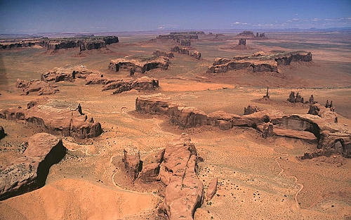
What DO they look like from above? They are randomly shaped with no directional orientation. Disclaimer - General impressions without that much specific data to back them (thus weasel words such as "seem to" and "suspect" used). I suspect that there is indeed some shape and preferred orientation, although it would be because of structural control and not "the flood". In photos the messas seem to at least sometimes have a rectangular plan view outline. In this map, the Oljeto Mesa appears to be generally rectangular with a northwest-southeast orientation of the long axis. There also seems to be some sort of northeast-southwest component there. To some degree, these orientations can also be seen in other mesas. I suspect (and closer study could confirm or deny such) that there is a strong regional orthogonal joint pattern that influences the weathering and erosion patterns (related reading on geology fractures). Moose
|
|||||||||||||||||||||||||||||||||
|
edge Member (Idle past 1734 days)  Posts: 4696 From: Colorado, USA Joined: |
Disclaimer - General impressions without that much specific data to back them (thus weasel words such as "seem to" and "suspect" used).
Generalizations? Here? No way! "Random" is kind of a subjective term, but you are correct.
I suspect that there is indeed some shape and preferred orientation, although it would be because of structural control and not "the flood".
This is always a good default position in western North America. I think that some earlier posts referred to these directions.
In photos the messas seem to at least sometimes have a rectangular plan view outline. In this map, the Oljeto Mesa appears to be generally rectangular with a northwest-southeast orientation of the long axis. There also seems to be some sort of northeast-southwest component there. To some degree, these orientations can also be seen in other mesas.
Even in Colorado, one of the principal structural directions is N40E.. Just say that, and 90% of the time, you will be right. I suspect (and closer study could confirm or deny such) that there is a strong regional orthogonal joint pattern that influences the weathering and erosion patterns (related reading on geology fractures). Ain't life wonderful?
|
|||||||||||||||||||||||||||||||||
|
Percy Member  Posts: 22502 From: New Hampshire Joined: Member Rating: 4.9 |
Faith writes: Just once it would be nice if someone acknowledged that I said something that makes sense. Anyone with a little scientific knowledge and reasoning ability is unlikely to accede to notions that have no evidence and that violate known natural processes and the natural laws of our universe, which is true of most of your ideas. If you'd like acknowledgement that you're making sense then you should develop hypotheses that don't have these fatal qualities. Most people interpret lack of acknowledgement that they're making sense as an indication that perhaps they're not making sense. --Percy Edited by Percy, : Grammar.
|
|||||||||||||||||||||||||||||||||
|
Percy Member Posts: 22502 From: New Hampshire Joined: Member Rating: 4.9 |
Faith writes: What DO they look like from above? They look like this:
AbE: If you'd like to see a satellite view, type "36.94,-110.1" into Google Maps, zoom out a bit, then turn on satellite mode. --Percy Edited by Percy, : AbE.
|
|||||||||||||||||||||||||||||||||
|
Percy Member Posts: 22502 From: New Hampshire Joined: Member Rating: 4.9 |
Faith writes: Good grief, once in a GREAT while I give the Biblical background and you try to pretend everything I've said is derived from it. I responded only to what you said in your message, noting that there was no evidence in support of any of it, much evidence contradicting it, and that some of your terms have no scientific meaning. It's much the same as all your other messages, mere bald assertions with no evidence. You may imagine within your own mind that there's some line of demarcation between the Bible and your own ideas, but both are completely without any evidential support, so any difference that might seem apparent to you is not apparent to anyone else. As I asked before, what evidence do you have that, interpreted by the actual laws of the universe (instead of ones you make up), leads to your conclusions? --Percy Edited by Percy, : Grammar.
|
|||||||||||||||||||||||||||||||||
|
Percy Member Posts: 22502 From: New Hampshire Joined: Member Rating: 4.9 |
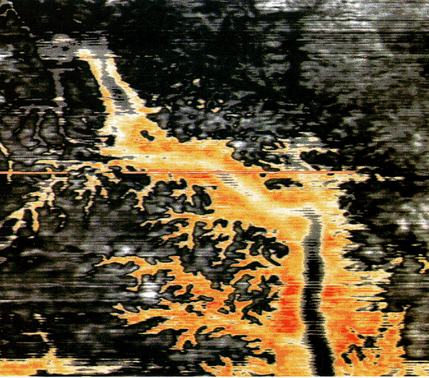
Faith writes: Water does run underground does it not? There are underground rivers are there not? They run in many places quite continually. Yes, there are rivers that run underground, but they have to have an above ground outlet (otherwise they could not flow, would have nowhere to carry sediment away, and would quickly plug up), and they do not have a host of tributaries feeding them. The image is of a complete river system with tributaries and canyons:
The different colors represent different types of material. You asked for evidence of buried buttes and canyons, so here is evidence of a canyon with buttes and mesas, the same as the Grand Canyon, except that it's buried. As explained earlier, the natural processes at work on the surface of the earth can produce canyons, buttes and mesas in uplifted regions through which rivers flow, and if such a region experienced subsidence and became a region of net deposition then any canyons, buttes and mesas would be preserved in the geologic record, as has happened here. One additional note. I parenthesized the fact that an underground river cannot flow if it has no above ground outlet and that it would have nowhere to deposit sediment. Your proposal that an underground river carved the canyon is yet another idea that isn't possible given our understanding of reality. A river cannot flow unless the water has somewhere to flow to, and a canyon cannot be carved unless a river carries away cubic miles of material. Both these basic requirements are absent in a river that flows completely underground. Underground rivers of the type you propose aren't possible. --Percy Edited by Percy, : Typo.
|
|||||||||||||||||||||||||||||||||
|
Percy Member Posts: 22502 From: New Hampshire Joined: Member Rating: 4.9 |
Hi Faith,
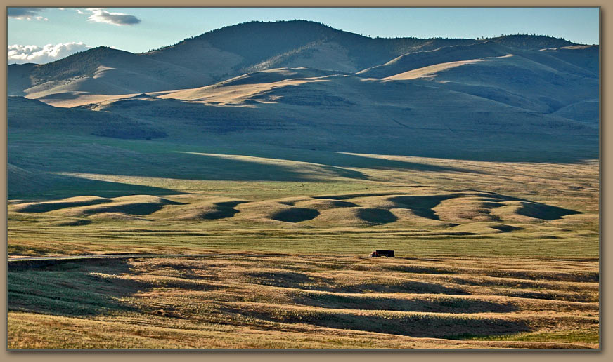
Though I'm replying to a message from Edge, this information is actually for you. It provides just a little more detail. The website again is Ice Age Floods-Discover Glacial Lake Missoula and Lake Bonneville. Here's a bigger version of the image of what Edge called megadunes but that are described at the website as giant ripples (click to expand):
Geologists have worked out that ripples like this form as a result of huge amounts of fast flowing water. The ripples in this image formed as a result of Lake Missoula emptying suddenly. You can see this image on the webpage at Explore Glacial Lake Missoula and the Catastrophic Ice Age Floods. I couldn't find a larger copy of this other image:
Edge will have to confirm, but I believe he presented this image as evidence of the existence of Lake Missoula because the horizontal lines across the mountain side are ancient shorelines. --Percy Edited by Percy, : I inadvertently typed "vertical" when I meant "horizontal", fixed now.
|
|||||||||||||||||||||||||||||||||
|
Percy Member Posts: 22502 From: New Hampshire Joined: Member Rating: 4.9 |
Hi Faith,
Just a little dBCode suggestion first: If you enter "[msg=328]" then you'll get Message 328, which has the additional advantage of providing a hoverbox of information (hover over the link, you'll see what I mean). That should be much easier than cut-n-pasting a URL into a "[url]" dBCode.
Faith writes: Well I still like my post 328 with all the diagrams of the GC-GS area because that massive erosion did all occur after all the strata were in place, which I would attribute partly to tectonic activity. What evidence can you produce of tectonic activity? What rocks are you looking at that you think were broken off of or broken down from larger rocks and then left behind by the flood, either because they were too big or the flood waters abated before they were carried away? Also, I think you're imagining that tectonic activity could break rocks up into pieces small enough to be carried away by your flood. Tectonic strain and earthquakes can produce faults (cracks) in rocks, but they don't generally break large rocks into smaller rocks to a point that would make them more amenable to being moved by water. As tectonic forces and earthquakes relate to erosion, they provide cracks that can provide opportunities for weathering forces, but they don't break entire landscapes into rocks of a size that a huge flood could then remove. Also, we've mapped the oceans pretty well. If tectonic forces had broken down landscapes into smaller rocks that a giant flood then transported to the sea, then we should see that debris all over the ocean floor. So we'd have to point to the oceans as yet another place where evidence for your ideas is absent. --Percy
|
|||||||||||||||||||||||||||||||||
|
edge Member (Idle past 1734 days) Posts: 4696 From: Colorado, USA Joined: |
Here's a bigger version of the image of what Edge called megadunes but that are described at the website as giant ripples (click to expand):
Yes, the story here is that although the dunes follow low areas across the countryside, there is no stream channel. The flows have exceeded the capacity of the existing streams by orders of magnitude. Note also that these features are not eroded away by flowing water, but are deposited by flowing water. There are a number of other features related to this 'breakout' type of flood, but I decided to focus on this one that is not as well known as some of the others.
Edge will have to confirm, but I believe he presented this image as evidence of the existence of Lake Missoula because the vertical lines across the mountain side are ancient shorelines.
I probably should have elaborated on these images, but I was kind of curious to see if Faith would take an interest and ask about them. Yes, the (horizontal) lines are ancient shorelines. There are a large number of them on the mountainside east of Missoula. One theory is that each represents a different generation of Lake Missoula. I'm not so sure about that, but they are definitely shorelines based on wave-washed sand deposits. These are common in many of the intermountain basins of western North America. The most interesting thing about them is that, for the larger lakes, they are presently arched and not perfectly level. This is because of isostatic rebound after removal of the huge amounts of water that previously filled the basin.
|
|||||||||||||||||||||||||||||||||
|
Percy Member Posts: 22502 From: New Hampshire Joined: Member Rating: 4.9 |
Faith writes: I think of the Rockies as being tectonically raised after the Flood. And as with all your other thoughts, you think this in the near complete absence of evidence. There's no evidence of a worldwide flood a mere 4300 years ago, and plenty of evidence that the Rockies began rising around 80 million years ago.
Faith writes: I don't want to fight about my view of the angular unconformity, otherwise I'd include it because I believe all that too was laid down in the Flood. At least the strata were. I don't think Edge is aware of your ideas about how the Grand Canyon Supergroup layers came to be tilted. He barely participated in the Why the Flood Never Happened thread. --Percy
|
|||||||||||||||||||||||||||||||||
|
JonF Member (Idle past 196 days) Posts: 6174 Joined: |
Google maps shows Monument Valley from above. Duh.
|
|||||||||||||||||||||||||||||||||
|
Percy Member Posts: 22502 From: New Hampshire Joined: Member Rating: 4.9
|
Faith writes: The Appalachians were formed by tectonic activity too. Yes. I acknowledge that this is supported by the evidence and makes sense.
All the mountains were formed about the same time when the original continent split at the Atlantic ridge. No. This is contradicted by the evidence and makes no sense. The Appalachians began forming around 480 mya, the North American Plate began moving away from the Eurasian and African Plates around 200 mya, and the Rockies began forming around 80 mya. That's what the evidence tells us. By the way, one key piece of evidence that the Appalachians formed before the separation of North America from Europe is that a piece of the Appalachians is in Ireland.
It merely buckled the Appalachians but it thrust up the Rockies rather precipitously, having a stronger impact on this end of the continent than on the east side. It made the angular unconformities in the GC GS area among other things. There is no evidence of this and it makes little sense. The only evidence here is evidence of your imagination.
It raised the Rockies. Assuming that "it" refers to tectonic forces, then yes, I acknowledge that this is supported by the evidence and makes sense.
It may have been the elevation in that direction that facilitated Flood water runoff. This is not supported by the evidence and makes no sense. While it is true that water will follow a gradient and therefore would flow away from the uplifted Rock Mountains, there's no evidence of any worldwide flood nor of any "water runoff" that resulted from a worldwide flood. --Percy
|
|||||||||||||||||||||||||||||||||
Faith  Suspended Member (Idle past 1472 days)  Posts: 35298 From: Nevada, USA Joined: |
The angular unconformity occurred, in my humble opinion. as a result of the tectonic activity AFTER the Flood. I know it's hard to keep the thoughts of a silly creationist in mind but I HAVE said this many times by now.
I can imagine some scenarios for intraformational disruption, all of them leave behind obvious and diagnostic evidence which is absent in the Grand Canyon section. In fact, the evidence leads to the contrary. This is nevertheless still my hypothesis for now.
That disturbance raised the whole stack, and it was also associated with the release of the volcano or volcanoes beneath the canyon area which issued in lava flows here and there and intrusions into the Precambrian rocks ...
Except that some of them are not intrusions... So?
,,, and the magma dike to the north of the GS which issued in lava at the top of the strata there.
All we are asking is for evidence. Which that dike is.
You can tell all the strata were already in place because the dike just goes straight from bottom to top. It didn't occur during the laying-down of the strata.
Not the Cardenas Basalt. Which I guess occurred during that period? But you also think an exposed Mississippian / Pennsylvanian rock is evidence of whatever happened to that rock during that supposed time period, which is not necessarily the case. Looks to me like all that sagging and sinking of that formation the name of which escapes my aging mind at the moment something Indian sounding, anyway all that most likely occurred after the rock above was eroded away, in other words in "recent" time. Same as the exposure of the Kaibab plateau which occurred in "recent" time and not in the Permian in which the limestone was supposedly laid down. Just because any particular phenomenon occurred at a particular location doesn't mean it occurred in the supposed time frame that location is said to represent. But perhaps the Cardenas is an exception. If you would ever bother to condescend to explain the things you say rather than just asserting them maybe I'd read more of your posts.
Same with the faults, which split the strata from bottom to top.
The younger faults, yes. So what? We know that the region was uplifted sometime in the Tertiary Period. Oh goody, there's something we agree on, since the uplift is associated with tectonic activity which is associated with all that massive erosion and the fault lines and the magma and so on...
An angular unconformity was the result to the north of the northernmost fault, with the Claron remaining horizontal over the tilted strata.
This is a cross-cutting relationship establishing relative age. If you want to prove otherwise, please do so. Your assertion is not evidence. The formation shown on the diagram is though, and I don't see anything there to suggest a difference in age identified by that fault myself. Same layers on both sides of the fault line, those to the south raised, those to the north much lower and tilted but with the Claron in place looking quite identical to its severed counterpart to the south.
Faith writes: There you have an example of an angular unconformity where the horizontal strata were clearly NOT laid down after the lower strata were tilted, because clearly the whole block of strata just dropped on the north side of the fault line, breaking off from the strata on the south side, all as a block. The Claron was broken also, was not deposited after the fault or it would not have deposited flat up against the fault line like that and the upper part of it would have fallen over the cliff and piled up. So there's an angular unconformithy that fits my model. I don't know if the north side dropped or was just tilted by the uplifting of the south side, perhaps you can tell me. But again I see nothing suggesting relative age except of course the fault line itself is younger than everything else, but the layers on both sides should be identical in age.
edge writes: Do you think that faults only move once? Sorry, but the Hurricane Fault system is long lived. Not sure exactly what you mean but if you mean it occurred in stages at earlier times in the laying down of the strata, there should be some sign of that in how subsequent layers were deposited and there doesn't seem to be. That is, the fault shifts the layers relative to each other so that deposition on top of them should be uneven at the fault line. There is of course a problem with the Hurricane Fault since the whole stack is tilted to the north beneath the Claron and I'm not sure what evidence might remain of what you are claiming. Is there any?
The Claron is deformed, but the underlying rocks are deformed even more. We call that a 'growth fault' (although the term is usually applied to faults that do not crop out). What is the significance of the Claron's being deformed and the rocks beneath it also?
So, no, you still have not provided any diagnostic evidence for your scenario. Your rather cryptic (assertional) way of answering me doesn't convince me of that though. As noted before, you seem to be much more invested in doing a snow job than in communicating anything. Edited by Faith, : No reason given.
|
|||||||||||||||||||||||||||||||||
|
Faith Suspended Member (Idle past 1472 days) Posts: 35298 From: Nevada, USA Joined: |
The rolling "megadunes" are interesting but what's the evidence that they are typical of rushing water everywhere? Isn't that area basalt? Is it possible basalt would ripple like that while other sediments might not? Also were layers above that layer also washed away in the same event? This is what I've been guessing for the Monument Valley area and I'm not sure your picture represents that area.
As for the other picture I have no problem believing Missoula existed, and would have left shoreline rings too. But of course I have a question about timing. Have you ever had a stopped up drain that drains slowly and leaves rings as it goes down? Edited by Faith, : No reason given.
|
|||||||||||||||||||||||||||||||||
|
|
Do Nothing Button
Copyright 2001-2023 by EvC Forum, All Rights Reserved
![]() ™ Version 4.2
™ Version 4.2
Innovative software from Qwixotic © 2024