|

Understanding through Discussion |
|
|
Register | Sign In |
|
QuickSearch
Summations Only | Thread ▼ Details |
|
Member  Posts: 3945 From: Duluth, Minnesota, U.S. (West end of Lake Superior) Joined: Member Rating: 10.0 |
|
Thread Info
|
|
|
| Author | Topic: Continuation of Flood Discussion | ||||||||||||||||||||
|
Dr Adequate Member (Idle past 305 days)  Posts: 16113 Joined: |
So half a million years and what I figured was 20 thousand feet in a million years so now it's down to 10 thousand feet since they were formed and they should still have eroded away to dust by that calculation. abe: Sorry the second figure makes it a tenth of that time so 2000 feet should be gone. What does that leave? At its narrowest point, the Channel is twenty miles wide.
|
||||||||||||||||||||
|
Dr Adequate Member (Idle past 305 days) Posts: 16113 Joined: |
We're eroding the CLIFFS, Dr A., not the channel. Eroding the cliffs widens the Channel, Faith.
|
||||||||||||||||||||
|
Dr Adequate Member (Idle past 305 days) Posts: 16113 Joined: |
40 to 60 million years is the age given for the rock from which the hoodoos were carved, by the Old Earthers who wrote the article for the National Park Service, whom I suppose to be real people, but I suppose they could be robots programmed to spout OE stuff. And the age of the rock is different from the age of the hoodoos. This is why I asked you for an instance of someone giving an erroneous date for any given hoodoo, rather that of someone giving an accurate date for the rock.
Do you have some reason to suppose that the hoodoos didn't start eroding at that point? Yes. For starters, if the hoodoos we have now had started being formed then, they wouldn't still be here. You can read some interesting stuff about hoodoo formation here.
The hoodoos have limited life-spans. What you see toward the top of the image is remnants of hoodoos, now transformed into the rounded hill erosions one would expect if normal arroyo wash processes had been dominant throughout. As Sprinkel et al. observe, the rim of Bryce Canyon is a passive topographic feature that retreats backward, estimated at about 4 feet per century, which would add up to 12 miles in a million years....
|
||||||||||||||||||||
|
Dr Adequate Member (Idle past 305 days) Posts: 16113 Joined: |
Sigh. OK. So it's 450 thousand down to 180 thousand years old, so that means that at the rate given by Percy if they are half a million years old they'd have added ten thousand feet to the English Channel, or at the lower age about 2000 feet since they were formed. Is that feasible? Yes. Because of the channel being twenty miles wide at its narrowest point, and a mile being 5280 feet.
|
||||||||||||||||||||
|
Dr Adequate Member (Idle past 305 days) Posts: 16113 Joined: |
But there is no reason whatever to suppose the erosion started recently enough for that to be the case. Since no Bryce Canyon hoodoo could last for millions of years, we may conclude that no given hoodoo in Bryce Canyon has been there for millions of years. That was your argument. That bit was correct. Where you went wrong was that you pretended that geologists claim that the present Bryce Canyon hoodoos are millions of years old, which they aren't. But you were right to say that they can't be.
The fact that they wouldn't be here if it started when of course it did start, right after the cliffs were formed ... * sigh * When were the cliffs formed? Note that the cliffs are different from the rocks and the time since there was a cliff face is different from the time that any given presently existing hoodoo was carved. Edited by Dr Adequate, : No reason given.
|
||||||||||||||||||||
|
Dr Adequate Member (Idle past 305 days) Posts: 16113 Joined: |
So you've explained away the hoodoos and Dover. How are you going to explain away the rate of erosion of the monuments in Monument Valley? I can hardly wait. What is it you don't understand about Monument Valley? I shall be happy to explain it, or as you would apparently phrase it, I shall be happy to explain away it. But perhaps now that you've seen how simple and obvious it is to understand erosion you could have a go at this one yourself.
|
||||||||||||||||||||
|
Dr Adequate Member (Idle past 305 days) Posts: 16113 Joined: |
All the time periods in the Geo Time Table, the CLASSIC Geo Time Table, that follow the strata of the Geo Column up up up and up through time, DO follow the strata, DO follow th physical ascent of the strata. It's only now that we're in the Holocene that it's OK for some reason for it NOT to follow the physical ascent of the strata because the physical ascent of the strata has in fact stopped. I say that's as good as declaring an end to the Geo time Table. Faith, this is drivel. Apart from anything else, the Holocene strata are, in fact, on top. I can't see what can be going through your head when you write stuff like this.
|
||||||||||||||||||||
|
Dr Adequate Member (Idle past 305 days) Posts: 16113 Joined: |
Yeah, but it's stopped and whatever is continuing is continuing NOT on top, so say you all. End of Geo Column, end of Geo Time Scale. This is also gibberish. Sediment is still being deposited. It is being deposited on top of whatever is present, there being no other way for sediment to be deposited. That is what we actually all say. I don't see how this is so hard for you to grasp. It isn't brain science or rocket surgery. Edited by Dr Adequate, : No reason given.
|
||||||||||||||||||||
|
Dr Adequate Member (Idle past 305 days) Posts: 16113 Joined: |
The Geo Column is an identifiable stack of strata that can also be identified by the order of fossils contained in some of the layers. The sediments are different from place to place and there may or may not be fossils in any given portion of the stack, but it is nevertheless an identifiable geologic structure. There shouldn't be any way to confuse it with other depositions. It's a stack, the layers are usually pretty thick, they were clearly laid down originally horizontally, and the contacts between the layers are often knife-edge close. They may be folded or otherwise distorted, but always as a block (although the whole block may not be distorted, such as in the case of the angular unconformity where the upper layers remain horizontal). So, you don't know what the geological column is. Perhaps you should have found out what it was before you started talking about it.
The geological column.
|
||||||||||||||||||||
|
Dr Adequate Member (Idle past 305 days) Posts: 16113 Joined: |
It's no longer even clear what you're trying to be wrong about, or how you're trying to be wrong about it. Yes, if sediment was laid down on top of the structures in that diagram, this would produce an angular unconformity such we can often see in the geological record. What of it?
|
||||||||||||||||||||
|
Dr Adequate Member (Idle past 305 days) Posts: 16113 Joined: |
That's very clever ... No it's not, Faith. It's bleedin' obvious.
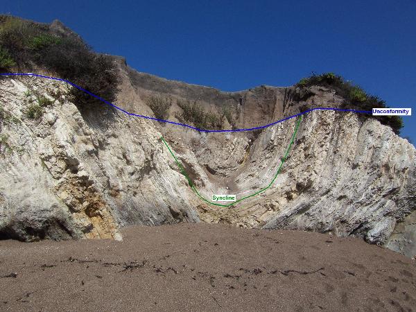
The thing is if a deposition did occur over that formation it would fill in the valleys and I haven't ever seen an angular unconformity in which the upper layers were anything but straight and flat both top and bottom, have you? Yes you have. I know you have, 'cos I've shown you photographs. If they put me in Who's Who right now they'd have to list "Showing Faith things that aren't flat" as one of my hobbies.
Also the upper layers occur over tightly folded lower layers, I've never seen one form over the kind of base in that diagram, have you? In theory that could happen but in reality there's no evidence that it ever does that I know of. Perhaps you can find some but I doubt it. I'm not sure what you're talking about. You mean something like this?
|
||||||||||||||||||||
|
Dr Adequate Member (Idle past 305 days) Posts: 16113 Joined: |
I wanted to see more of the upper part of that picture, but that's OK. As usual it defies the way things are in reality that folded layers would be eroded flat on top like that unless there was more than just weather to work on them, such as a deep stack of sediments above that resisted the movement below. I've seen Roadrunner cartoons that exhibited a better grasp of physics.
|
||||||||||||||||||||
|
Dr Adequate Member (Idle past 305 days) Posts: 16113 Joined: |
What it looks like is that sediment has been deposited on top of rocks that have first been folded and then eroded. It looks exactly like that would look. Can you think why?
|
||||||||||||||||||||
|
Dr Adequate Member (Idle past 305 days) Posts: 16113 Joined: |
It's at times like this that I wonder whether you are actually blind or merely mad.
Edited by Adminnemooseus, : Big off-topic banner.
|
||||||||||||||||||||
|
Dr Adequate Member (Idle past 305 days) Posts: 16113 Joined: |
What I've been calling the Geologic Column is called at Wikipedia the Stratigraphic Column. No. A stratigraphic column is specific to a particular location. (Hence, of course, there is no such thing as "the stratigraphic column".)
|
||||||||||||||||||||
|
|
Do Nothing Button
Copyright 2001-2023 by EvC Forum, All Rights Reserved
![]() ™ Version 4.2
™ Version 4.2
Innovative software from Qwixotic © 2024