|

Understanding through Discussion |
|
|
Register | Sign In |
|
QuickSearch
| Thread ▼ Details |
|
Thread Info
|
|
|
| Author | Topic: Earth science curriculum tailored to fit wavering fundamentalists | |||||||||||||||||||||||||||||||||||||||
|
edge Member (Idle past 1733 days)  Posts: 4696 From: Colorado, USA Joined:
|
I guess what I'm struggling with is calling the scientific position on this "assumptions" rather than conclusions based observed evidence.
I'm not sure what would be intrinsically wrong with assumptions. Do you, or does anyone in your audience go though life without making assumptions? Clearly, some assumptions are valid and others not. What your skeptical 'audience' needs to do is show that the assumptions are not valid if they wish to proceed with the argument. The point here is that uniformitarianism, in its present form (which we term 'actualism') has not been shown to be invalid for the explanation of natural features. Now, if someone wants to be hyperskeptical, that's their problem. I recommend that they not board an airliner for travel purposes.
It seems to me that in the physical realm where we can explore, if floods really did sort by species at some point, then what we would find is fossils in flood sediment sorted by species, etc. We don't have to assume it wouldn't happen -- we can just look at the evidence.
There is a bit of a misunderstanding here. Floods do their sorting (if it really happens) of species in space. Evolution sorts species through time. This notion on your part suggests to me that you still retain the YEC understanding that there is one geological event in the history of the earth, and everything really happened at once. Frankly, it appears to me that you are not being completely honest here.
Again, I'm not trying to argue with an "I'm right" attitude, I'm just trying to figure out how to explain this to my audience. The way the wiki quote is portrayed, it's just as valid to assume "god did it" as to say that gravity is a historical constant - it's a 'he said, she said' situation (or that's how the YECs would see it). It just seems to me that the historical constant of gravity is backed up by evidence rather than assumption.
Uniformitarianism is more than just an assumption. It is a principle that is used to interpret natural phenomena. It has survived since the days of Hutton, though our understanding of what is normal has changed. In our modern usage, it does not exclude catastrophic events such as meteorite impacts, etc. YECs would have us believe that the biblical flood refutes uniformitarianism. However, there has never been any evidence to support such an event. Consequently, the only people who deny uniformiatrianism do so for biblical (i.e. religious) reasons, not scientific ones. Basically, this requires a belief in such ideas as C-decay or alternate states, or magic (that would be supernatural intervention). All of these, of course, leave no evidence behind. Really, if you want to refute a geological principle, you need to show that it is scientifically invalid.
Thanks. Still pondering.
Ponder harder. Edited by edge, : No reason given.
|
|||||||||||||||||||||||||||||||||||||||
|
edge Member (Idle past 1733 days) Posts: 4696 From: Colorado, USA Joined: |
When you have an all powerful god, why would you need to depend on the consistency of natural law and process?
If an all-powerful god actually acted upon that power, science wouldn't work.
|
|||||||||||||||||||||||||||||||||||||||
|
edge Member (Idle past 1733 days) Posts: 4696 From: Colorado, USA Joined: |
So, in reading article after article on carbon dating, I came up with this tidbit from a 1982 NCSE article and it seemed to contradict my understanding. I'd like some help if possible figuring out where my understanding has fallen down (or if the article is just incorrect).
Not sure what your question is. The chart shows a peak 14C level in 1963 which was the year of the Limited Test Ban Treaty was signed, ending atmospheric tests for US, UK and the USSR. The level has been declining ever since. This is what we would expect.The quote in question is from this link: http://ncse.com/...s-to-creationist-attacks-carbon-14-datingAnd here's the quote. I have green highlighted the part I am questioning. quote:Question: Creationists such as Cook (1966) claim that cosmic radiation is now forming C-14 in the atmosphere about one and one-third times faster than it is decaying. If we extrapolate backwards in time with the proper equations, we find that the earlier the historical period, the less C-14 the atmosphere had. If we extrapolate as far back as ten thousand years ago, we find the atmosphere would not have had any C-14 in it at all. If they are right, this means all C-14 ages greater than two or three thousand years need to be lowered drastically and that the earth can be no older than ten thousand years. How do you reply? Answer: Yes, Cook is right that C-14 is forming today faster than it's decaying. However, the amount of C-14 has not been rising steadily as Cook maintains; instead, it has fluctuated up and down over the past ten thousand years. How do we know this? From radiocarbon dates taken from bristlecone pines. The reason this caught my eye is my familiarity with the following 'bomb carbon' chart. If as the chart shows (and I've seen many charts confirming this) C14 levels were still falling dramatically in 1982 after artificially high levels from open air bomb tests, how could C14 be forming faster than it was decaying. I haven't been able to find a graph that continues this reporting to the current day (2005 is the latest I've found and it was still falling at that time) to know what it's doing today. What's up? I would normally consider NCSE a reliable science source. JB China's last atmospheric test was in 1980. I don't know of anyone age-dating objects less than a hundred year old. It seems you might be confusing two time ranges here. ETA: I see that the chart shows declining 14C as the NCSE article states. I also see that the rate of production is still higher than an equilibrium state. That is because the production, while high, is declining eventually back to natural levels. So, the NCSE article is correct. Nulear testing temporarily raised the production level and the amount of 14C in the atmosphere. We are now going back to equilibrium. It is just taking a while. Edited by edge, : No reason given. Edited by edge, : No reason given.
|
|||||||||||||||||||||||||||||||||||||||
|
edge Member (Idle past 1733 days) Posts: 4696 From: Colorado, USA Joined: |
This does not make sense. There are places in this description where you are using the second derivative of the amount of C-14, when only the first derivative is appropriate. If you want to answer the question of why the amount of C-14 is declining, that happens only when the rate of production is less than the rate of removal.
Right, it is confusing. I think Weber discusses variation of the natural 14C, but that is not what the chart emphasizes (particularly since it only goes back to 1955).
|
|||||||||||||||||||||||||||||||||||||||
|
edge Member (Idle past 1733 days) Posts: 4696 From: Colorado, USA Joined: |
I could use some help from the geology experts. From my (inexperienced) research, it appears that Hovland is a legitimate scientist with some relevant cred. It appears that he has thrown out a researched hypothesis regarding the formation of *some* saline giants (and having nothing to do with YEC). It also appears (as usual) that one YEC creationist has run to the mountain tops with this hypothesis as written in stone directly from God and the creationist web sites have picked up on this one guy as a writer of gospel.
Wow, this is another one of those YEC-type explanations that we used to say, 'doesn't approach the level of being wrong'. This started near a decade ago (original paper) and so I'm wondering if it's been largely dismissed or confirmation is in process? Not sure how slow things move in the geology world. It would seem to me that geologists might have ways of looking at the the crystal structure (ignorance alert here) in the salt that could determine if salt was laid down by evaporation or the supercritical process, but from the critique article, it may not be that simple. Before anything else, I will admit that I have not researched nor read all of your references, but after reading the abstract by Hovland, I have a few observations right of the top of my head. My first questions are about the size and shape of the salt deposits: Hovland mentions the GOM salt deposits, which primarily refers to the Luann Salt which, curiously, has a source confined to the Jurassic System in the Gulf area. To me this is kind of weird. To have a regional alteration pattern confined to one age and one rock type that forms a nice, tabular deposit, parallel to stratigraphy, just stretches the imagination. For reference, this map shows how large that deposit is.
If you look at the size of this deposit, one wonders exactly where is the intrusion that caused so much seawater to boil (which it won't do, by the way, due to hydrostatic water pressure). It's got to be huge, and yet there is no evidence of it; not even a gravity anomaly or a remnant thermal anomaly. Another argument is with regard to the Red Sea. We see plenty of salt deposits forming in the evaporative way in the adjacent Afar region (an almost identical and continuous geological setting), so why does Hovland have to reach for a magmatic-replacement origin for the salt? And where are the salt deposits at the modern mid-ocean ridges? Sure, the rocks are enriched in sodium, but never do we see huge salt deposits... Neither do I see any chemical formulas showing the reactions to form such a replacement of sedimentary minerals by salt. Nor do I see an explanation for the purity of the salt beds. The author should be able to show us some replacement textures, even if they are synthetic, to provide some evidence that this could happen. What was the protolith (original rock type) of the 'replaced' bed? What is the composition of the intrusion? Maybe all of this information is reported somewhere in the sources that you cite, but my guess is that they are not. As you note the paucity of information on this subject suggests that it is a red herring. I have no idea (well, maybe one...) why anyone would postulate such an origin of regional salt beds based on such flimsy arguments.
|
|||||||||||||||||||||||||||||||||||||||
|
edge Member (Idle past 1733 days) Posts: 4696 From: Colorado, USA Joined: |
Well, I can say for certain what is motivating Stef Heerema to take Hovland's work and make YEC gospel out of it - there's no need to guess on that one if you read or watch him, but since there's nothing in Hoveland's material anywhere referencing YEC, nor can I find any statements he has made to any YEC site (they would surely promote them), I'm not yet ready to impune Hovland on the basis of any theology. . That of course isn't an endorsement of the quality (or not) of Hovland's work in any way. I ask that question so others with more experience can read and commentWell, I'm getting some conflicting ideas here between the website and the abstract, so I'm going to shut up until I read more and if the discussion goes any further. Just let me say that deposits such as the Afar (modern) and the Green River Basin (ancient), the Luann Salt (ancient) and the Great Salt Lake Basin (modern) do not look like they could be formed in the way that Hovland seems to suggest. But then I'm not sure what he's saying yet, since he also mentions sabkhas, which are a different animal entirely. ETA: And yes, I'm sure that Heerma is using Hovland's work to support the old argument that salt deposits can form in other ways than by evaporation. But he leaves out this statement by Hoveland:
Large, buried salt bodies occur in numerous offshore rift-related sedimentary basins, worldwide. For most practical purposes, the conventional evaporite (solar evaporation of seawater) theory is adequate for explaining these occurrences. Just a moment... The idea is to show that 'evaporites' can form in 'flood' conditions. My counter is that we have a perfectly good explanation that accounts for the actual features of the known deposits and the Hoveland model (which may have some application) is not adequate to explain all deposits. Edited by edge, : Amplify on the arguments
|
|||||||||||||||||||||||||||||||||||||||
|
edge Member (Idle past 1733 days) Posts: 4696 From: Colorado, USA Joined: |
A question driven by total ignorance on the topic:
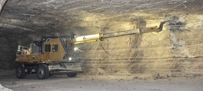
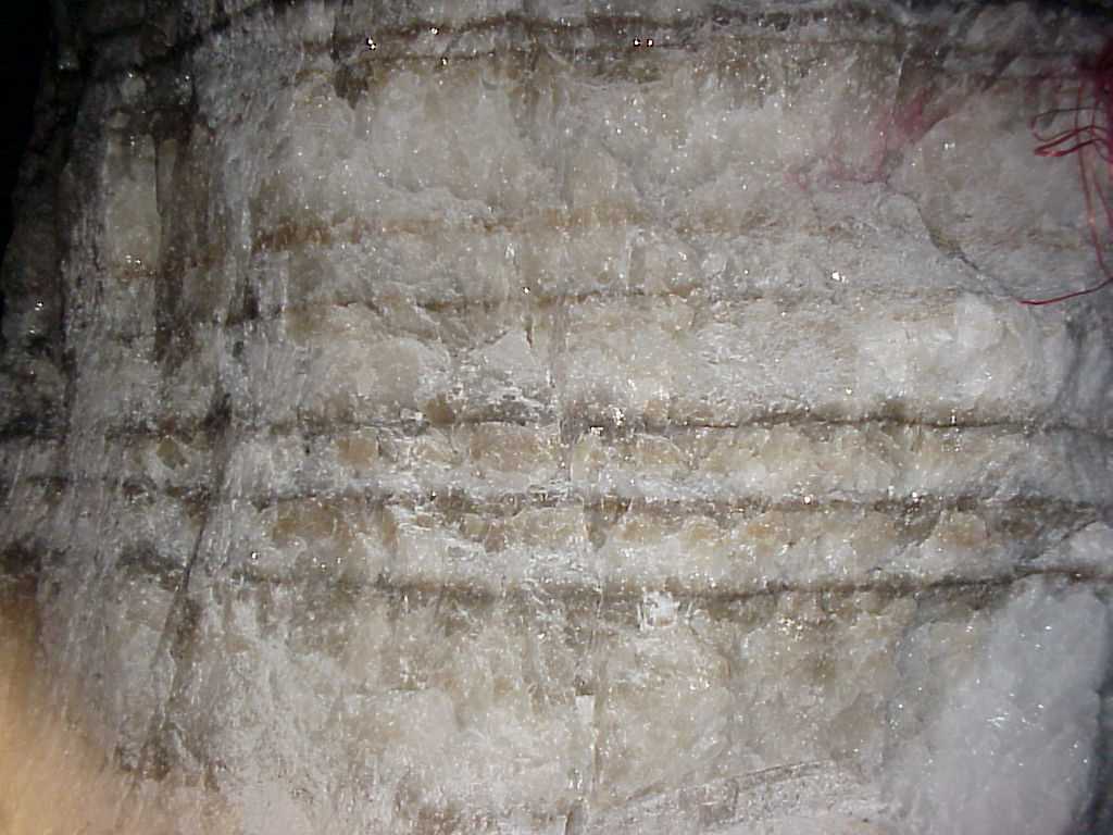
The layering is certainly sedimentary in origin.I do a Google image search on "salt mine" and in image after image I see visible layers in the walls. Would that not be impurity layers in the salt indicative of the normal open air evaporative process - dust, etc? Would halite deposited by the method proposed by Hovland show these distinct layers? Seems if it's done all underground it would be homogeneous with no orderly layers of impurities (if those layers I see are indeed impurities). Now, if one were on the hard-core hydrothermal-replacement bandwagon, one could say that the replacement is so detailed, so precise and so faithful to layering, is a perfect replication of the original sedimentary texture. Over large distances (regional scale), I would say that's never been seen before. Is it recrystallized? Sure, that's the nature of salt deposits. But to present no other metamorphic textures tells us that it is not thermal in origin.
Also, can this halite be dated through radiometric/other? If so I would think that would be a way to distinguish between the methods of deposition in any given deposit.
Radiometrically, no, unless there are volcanic ash layers that could be dated. They could, however, be dated by index fossils, such as pollen grains. Edited by edge, : No reason given.
|
|||||||||||||||||||||||||||||||||||||||
|
edge Member (Idle past 1733 days) Posts: 4696 From: Colorado, USA Joined: |
I would think that you would find some fairly serious thermal alteration in the rocks near any salt deposits that were from Hoveland's mechanism of deposition. I'm pretty sure there is no evidence of that near the Louann - the Cotton Valley Lime sure doesn't show signs of prolonged baking.
Absolutely. Even at 800 degrees C, there should be some kind of zonation of thermal metamorphism, especially considering the size of the system we are discussing. Those temperatures are the equivalent of the final solidification of a granitic magma. These things are pretty well-recognizable by mineralogists. Basaltic magmas (which we would expect in a rifting environment such as the Red Sea) would involve even higher temperatures (up to 1100 C) which would have an even more intense thermal aureole. The whole thing just doesn't make much sense, except in some very narrow applications and even then, I've never seen anything like what Hovland is describing. ETA: His schematic diagram of fluid flows is unlike any that I have ever seen before; and again, it doesn't look realistic. I would still like to see the chemical reactions that would lead to salt precipitating (I seriously doubt actual replacement) in a hydrothermal environment. Edited by edge, : No reason given.
|
|||||||||||||||||||||||||||||||||||||||
|
edge Member (Idle past 1733 days) Posts: 4696 From: Colorado, USA Joined: |
So, my task is to create presentations that can as simply and reliably as possible show two things:
If our experience here is any indication, the task is insurmountable. In 99.9% of cases, religious belief trumps scientific evidence and reasoned interpretation.
1: the evidence is clear that the layers at and above the lowest fossil bearing layers (precambrian?) could not be young. 2: the evidence shows that a Noahic flood didn't happen.
|
|||||||||||||||||||||||||||||||||||||||
|
edge Member (Idle past 1733 days) Posts: 4696 From: Colorado, USA Joined: |
|
|||||||||||||||||||||||||||||||||||||||
|
edge Member (Idle past 1733 days) Posts: 4696 From: Colorado, USA Joined: |
What you'll have there is bands of normal lacustrine or marine sediment, usually mud though of course I can't tell from the photograph.
These are the Michigan Basin salt deposits with which I have actually done test work on.
They are true evaporite deposits.
Such layers are associated with seasonal changes, effectively being varves, or larger-scale alternations are associated with transgressions and regressions, as described for example in this paper. Look particularly at the table at the bottom left of page 414.
I think the changes you are discussing are at a larger scale in the Zechstein Salt. As you can see these beds are almost pure salt and the muds or clays are simply contamination. The zonation that you refer to is excellent evidence for evaporative origin of the salt deposits that no one here has discussed previously. In a lacustrine environment it is possible to predict the order and distribution of salt minerals. Edited by edge, : No reason given. Edited by edge, : No reason given.
|
|||||||||||||||||||||||||||||||||||||||
|
edge Member (Idle past 1733 days) Posts: 4696 From: Colorado, USA Joined: |
I was trying to figure out if the supercritical water method would also sort the dissolved content in the same way.
It would not. Just look at the flow directions. In the Hovland model the continuity is vertical and would result in a vertical zonation along structural pathways. In the evaporative model the continuity is lateral with zonation being in lateral directions controlled by stratigraphic processes.
|
|||||||||||||||||||||||||||||||||||||||
|
edge Member (Idle past 1733 days) Posts: 4696 From: Colorado, USA Joined: |
Being one of the 0.1%, I don't disagree with that at all. I happen to have several family members here who seem particular vulnerable to truth right now so I am hoping for a bit better odds in this specific case. The important thing to me is to be well prepared. When someone is vulnerable to truth and asks an idiot (or even a well meaning ignorant) an important question, a nonsensical answer can really turn them off.
True enough. I'm afraid I get pretty cynical participating in discussions like we have around here sometimes.
|
|||||||||||||||||||||||||||||||||||||||
|
edge Member (Idle past 1733 days) Posts: 4696 From: Colorado, USA Joined: |
To make it clear, I didn't mean to imply that the bands in the photo would be pure mud. Some of them just might be, but they are much more likely muddy salt, or possibly salty mud.
Well, they are almost all impure to some degree. However, the part that is mined is as pure as possible. The samples I've dealt with are light grayish brown with very large crystals up to several mm in dimension. That size would be very difficult if there were a lot of impurities such as clays, etc. If you look at the salt flats in Utah, the salt is almost pure halite, so they look almost pure white, even from space. Go to the Morton Salt website if you want to see some pictures of those facilities. The impurities there are mostly wind-blown silt and pollen, etc. But if it goes on the table, it's got to be clean. If you look at the underground picture on earlier pages, I'm pretty sure that the roof (or 'back') is more of a siltstone, otherwise it wouldn't have the tensile strength to stand up. Pure salt is quite weak, especially in the coarser grained variety and it will crumble, or it will flow if confined. A lot of these features of salt are what make it so economically attractive. If you have a good salt mine in the northern states, just line up the trucks and start counting your money.
|
|||||||||||||||||||||||||||||||||||||||
|
edge Member (Idle past 1733 days) Posts: 4696 From: Colorado, USA Joined: |
That was my uneducated thought as well but I wasn't sure - things that happen exposed to air on the surface would almost certainly look different.
It is absolutely possible, and usually easy, to tell subaqueous volcanic deposits from subaerial deposits. There are all kinds of variations depending on the type of volcanic eruption, its composition and the depositional environment. (Ignorance alert!!) For instance, I would think one could tell by looking at the cooled lava around a volcano and determine to a great degree of certainty if it was an underwater eruption or not. In fact I would think there would be several ways to tell. I know that how things cool (slow or fast) changes how they look under a microscope. Also lava can flow for miles with little fall in the open air, where with rapid water cooling it would not be able to do that. Of course I know shit about volcanos, so that's mere supposition on my part based on other things I do know. ETA: Oh, yeah, and whatever happened afterward. Edited by edge, : No reason given.
|
|||||||||||||||||||||||||||||||||||||||
|
|
Do Nothing Button
Copyright 2001-2023 by EvC Forum, All Rights Reserved
![]() ™ Version 4.2
™ Version 4.2
Innovative software from Qwixotic © 2024
 (1)
(1)