|
QuickSearch
Welcome! You are not logged in. [ Login ] |
EvC Forum active members: 63 (9071 total) |
| |
FossilDiscovery | |
Percy | |
Total: 893,109 Year: 4,221/6,534 Month: 435/900 Week: 141/150 Day: 11/23 Hour: 0/2 |
Thread ▼ Details |
Faith  Suspended Member (Idle past 675 days) Posts: 35298 From: Nevada, USA Joined: |
|
Thread Info
|
|
|
Author | Topic: Evidence that the Great Unconformity did not Form Before the Strata above it | ||||||||||||||||||||||||||||||||||||||||||||||||||||
Percy Member Posts: 20745 From: New Hampshire Joined: Member Rating: 2.2
|
Hi Faith,
I don't see you saying anything new in this thread. These are the same arguments you've made in previous Grand Canyon discussions. This has been pointed out before in this thread (and countless other threads), but your view of what happened is impossible because it requires cubic miles of rock to just disappear. The layers in this diagram represent the layers in the Grand Canyon region as you imagine them before the uplift. The sky blue layer represents the top layer of the supergroup, the tan base is the Vishnu Schist:
You propose that tectonic forces tilted just the supergroup layers and not those above to form this:
This is impossible because it requires cubic miles of rock to just disappear. The sky blue layer and the layers beneath it represent cubic miles and miles of rock, and apparently in your view most of these layers with their cubic miles of rock just disappears. That is impossible. The Grand Canyon Supergroup is the remains of an ancient and typical basin and range formation that occurs as a region is stretched:
We can tell that the region became elevated because this basin and range composed of supergroup layers was then eroded flat, the layers of the supergroup completely disappearing in many areas. Subsidence and/or rising seas or some combination caused the region to become submerged and marine layers began depositing atop the tilted supergroup layers, starting with the Tapeats. --Percy Edited by Percy, : Typo.
|
||||||||||||||||||||||||||||||||||||||||||||||||||||
Percy Member Posts: 20745 From: New Hampshire Joined: Member Rating: 2.2 |
It isn't new. Your claim has always been that the layers of the supergroup and all the layers above them were deposited at the same time by the flood.
In Message 3 and Message 6 PaulK does appear to be saying that the layers were deposited after the uplift. Since that's absurd he must be saying something else. Marine layers could not possibly have been deposited on a terrestrial uplift. I don't know what contours he's referring to when he says, "First it is possible for sediment to drape over existing contours provided friction and adhesion are sufficient to keep it in place." What he says is true in some contexts, but if he's referring to your diagram where you show layers butting up against the sides of the Grand Unconformity, then no. Calling the uplift a "mound" is misleading. The tilt is very, very gradual. The exaggeration of the vertical direction of most diagrams has already emphasized repeatedly in this thread.
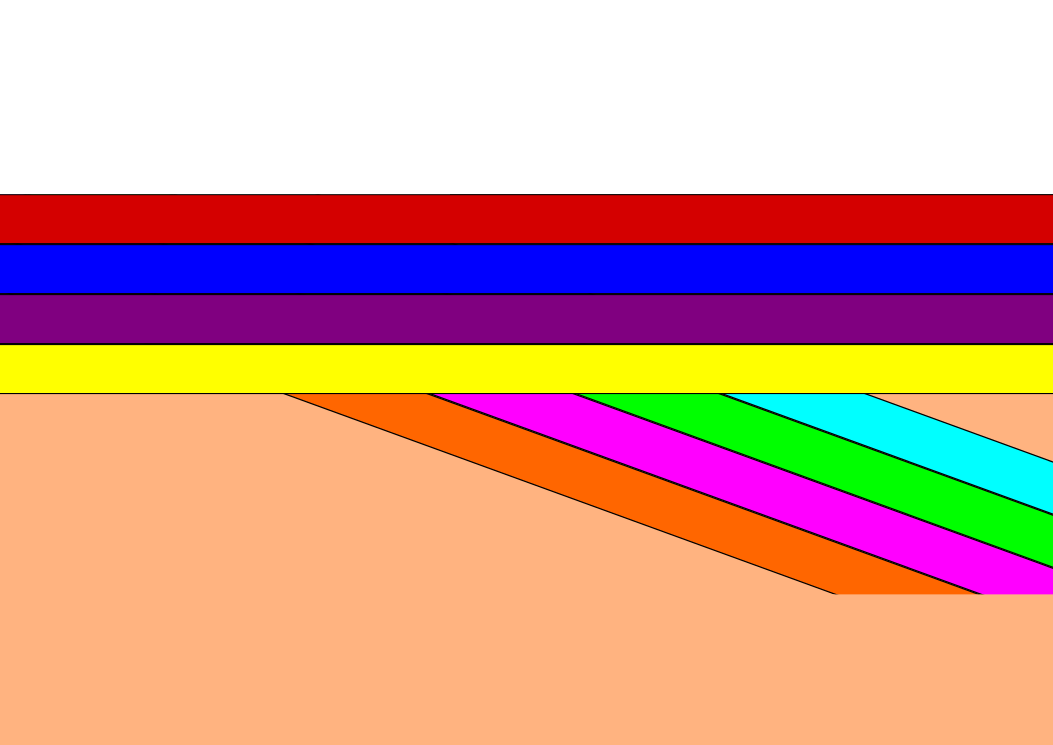
As all diagrams clearly show, the top of the tilted G.U. was eroded fairly flat before more layers were deposited atop it. The differences in radiometric dates make clear that the formation of the G.U. was followed by an immense timespan before the formation of the layers above. --Percy
|
||||||||||||||||||||||||||||||||||||||||||||||||||||
Percy Member Posts: 20745 From: New Hampshire Joined: Member Rating: 2.2
|
No one is claiming the uplift was already present when the layers were deposited, but that's only a 3% slope. Take a foot-long ruler, lie it on a table surface, put a pencil under one end. That's a 3% slope. Layers will have no problem accumulating on such a mild slope. You said this in Message 44:
You're not providing any evidence. Obviously you think you are, so what is it? In your Message 1 you didn't describe any new evidence, just "THINGS TO NOTICE" that were incredibly obvious. Not only had everyone already noticed them, they've been discussed, with you, in previous threads.
That's your problem if you find absurd the process of erosion gradually flattening landscapes. It's a process we can see occurring in the world today, and one we find has happened enumerable times in the past.
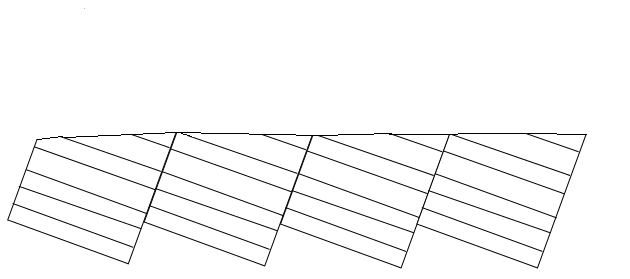
Erosion erodes whatever is there, whether it's been tilted from its original orientation or not. Look at this diagram of the formation of a basin and range again:
Look at the last step in the process, the bottom drawing. This is a typical basin and range. The highest parts of the exposed top portions of the tilted blocks form mountain ranges. The lowest parts of the exposed top portions of the tilted blocks form valleys. Here's my own rendition of the last stage in the formation of basin and range:
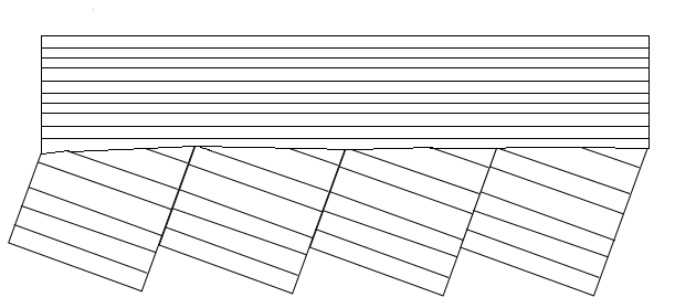
This next diagram shows what happens as the forces of weathering begin to work on the new landscape. The topmost parts of the layers that are sticking up begin to erode away (the mountains) and the eroded material accumulates in the lowest regions (the valleys):
The weathering of the high regions and the transport of the eroded material by the forces of wind and water into the lower regions continues:
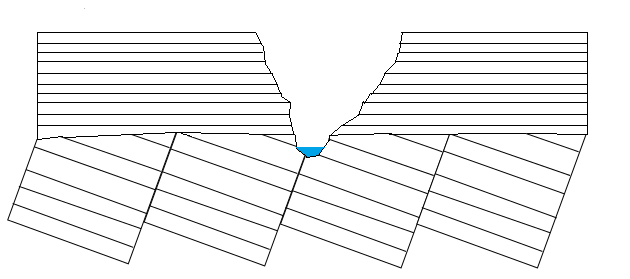
The exposed top layers of the tilted blocks are eroded away until they are completely gone, exposing the layers below which are also eroded, eventually leaving only a flat plain atop tilted layers.
If the region should subside and become submerged then layers will begin accumulating atop them:
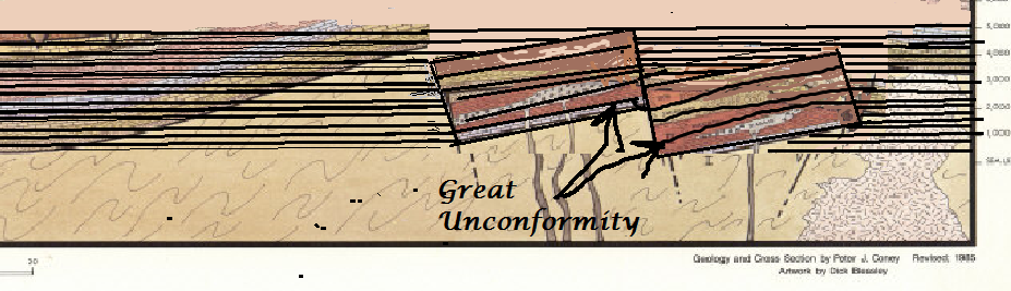
If the region is again uplifted and subjected to erosion and if a river flows through the region as it is uplifted then a canyon will be cut into the layers:
This is what happened at the Grand Canyon. --Percy Edited by Percy, : Fix quote. Edited by Percy, : Typo.
|
||||||||||||||||||||||||||||||||||||||||||||||||||||
Percy Member Posts: 20745 From: New Hampshire Joined: Member Rating: 2.2
|
If by "butted up against it" do you mean the way your diagram shows new layers forming adjacent to the supergroup layers and butting up against them (Your diagram is mislabeled, by the way - what you've labeled the Great Unconformity is actually layers of the supergroup. The Great Unconformity is at the boundary at the very top of the supergroup layers. That boundary is at an angle to the supergroup layers themselves, and your diagram fails to show that, too.):
If this is what you mean, there is no evidence that anything like this ever happened. The Vishnu Schist adjacent to the supergroup layers were already there when the supergroup layers were deposited. When the stretching of the continent caused all the faulting that formed the blocks of basin and range then the lowest supergroup layers slipped to be adjacent to older Vishnu Schist layers. What we see in the region of the Grand Canyon you're looking at is just the very lowest and oldest layers of the supergroup. See my previous Message 88 for a detailed illustration of how the layers at the Grand Canyon formed. --Percy
|
||||||||||||||||||||||||||||||||||||||||||||||||||||
Percy Member Posts: 20745 From: New Hampshire Joined: Member Rating: 2.2 |
But your final comment on the topic was just a couple days ago in Message 131:
So I didn't bother replying to your last message to me, and I didn't poke my nose in as moderator when the topic drifted because you, the thread's originator, had abandoned it. But if your comment that the thread is now off-topic means you want to resume discussing the topic then I think only a statement of what you really meant to say in the OP is needed. --Percy
|
|
|
Do Nothing Button
Copyright 2001-2018 by EvC Forum, All Rights Reserved
Version 4.1
Innovative software from Qwixotic © 2022