|

Understanding through Discussion |
|
|
Register | Sign In |
|
QuickSearch
| Thread ▼ Details |
|
Suspended Member (Idle past 1465 days)  Posts: 35298 From: Nevada, USA Joined: |
|
Thread Info
|
|
|
| Author | Topic: Evidence that the Great Unconformity did not Form Before the Strata above it | |||||||||||||||||||||||||||||||||||||||||||
|
Minnemooseus Member  Posts: 3945 From: Duluth, Minnesota, U.S. (West end of Lake Superior) Joined: Member Rating: 10.0 |
ll right, this needs a lot of clarification. The angular unconformity at Siccar Point is the entire formation that includes both the upper horizontal layer and the vertical layers beneath. This is how I've been regarding the physical presentation of the Great Unconformity as well. To reduce it merely to the eroded contact line makes no sense to me. The unconformity is the contact ("contact line" in cross-section). It is an unconformity because of the nature of the rocks below and above. There is evidence of a major time break - Deposition, folding, erosion, more deposition. Moose
|
|||||||||||||||||||||||||||||||||||||||||||
|
Minnemooseus Member Posts: 3945 From: Duluth, Minnesota, U.S. (West end of Lake Superior) Joined: Member Rating: 10.0 |
From here:
Faith writes: Edge writes: Well, it doesn't have to, I suppose, but it probably did. First of all, the development of a schist (with a platy foliation) is dynamothermal, meaning that there was deformation along with heating. If the intrusion caused the schist development, then there should be some geometric relationship of the intrusion to the orientation of the foliation. That does not appear to be the case. As to the burial origin of the foliation, if that is due to the Paleozoic section being deposited, then the foliation should be closer to vertical. In fact, IIRC, there are some folds in the schist, which would suggest some kind of lateral compression. I wonder if you would be so kind as to translate these paragraphs into simple English for us mentally challenged YECs? I would really like to have some idea what you are talking about. First of all, I think Edge had an error. I think a sentence above should have been "As to the burial origin of the foliation, if that is due to the Paleozoic section being deposited, then the foliation should be closer to horizontal". The greatest pressure is perpendicular to the foliation. The metamorphism of the schist require heat and high pressure. The non-metamorphism of the overlying sediments requires the lack of heat and high pressure. The sediments were not there when the schist metamorphism happened. Vishnu Basement Rocks - Wikipedia:
CORRECTION - The above link was to the wrong location in the article. Below is the correct location. Vishnu Basement Rocks - Wikipedia:
quote: And that unconformity is a nonconformity - It is sediments on top of basement metamorphics and intrusives. Now the above quoted is a bit muddled. But, pressure means deep burial. Per my interpretation of the above quoted, what became the Vishnu Schist was once buried under approximately 25 kilometers of other material (The summit of Mt. Everest is about 9 kilometers above sea level). Perhaps that interpretation is wrong. But if so, that means that 25 kilometers of material was eroded off before the deposition of any of the currently overlying sediments. Before I researched this a bit, my WAG (wild-ass-guess) was that at least 10 kilometers of burial was required for the metamorphism to happen. That's still an Everest height of sediment that had to have been eroded off, before the depostion of the Unkar Group. And that takes time, and that's before any of the sediments were deposited, which requires more time. Not going to happen in 6-10,000 years. Moose Edited by Minnemooseus, : Fix quote box. I don't use [quote] much. Edited by Minnemooseus, : Corrected a link. Had been to the wrong place in the right article. Edited by Minnemooseus, : Neglected to include a closing " mark.
|
|||||||||||||||||||||||||||||||||||||||||||
|
Minnemooseus Member Posts: 3945 From: Duluth, Minnesota, U.S. (West end of Lake Superior) Joined: Member Rating: 10.0
|
The quotes are piling up, but it seems necessary.
Faith writes: Moose writes: The metamorphism of the schist require heat and high pressure. The non-metamorphism of the overlying sediments requires the lack of heat and high pressure. The sediments were not there when the schist metamorphism happened. In my scenario they were and there is no reason to suppose the intense heat reached to that level, especially if the entire region was soaked in Flood water as I hypothesize that it was. The blocks of tilted Supergroup also weren't metamorphosed, I assume for the same reason, but I still think the Vishnu contains the rubble from the Supergroup that is no longer in evidence AS Supergroup. Oddly, one of the layers of the Supergroup is metamorphosed, the Shinumo quartzite. Enough heat and pressure for that without affecting the others? I don't know but that's the lines I'm thinking along. As Edge said in the previous message, there's no way to shut off the metamorphism, especially that radically, at the contact. The sediments would have shown some signs of pressure and heat effects. The schists etc. structures and compositions (see Vishnu Basement Rocks - Wikipedia) are not compatible with a Supergroup protolith (pre-metamorphism form). Re: Shinumo Quartzite - Unfortunately, that name does not require metamophism. It means that the quartz sandstone is so well silica cemented that the rock can break through the sand grains, rather than just between the grains. Besides, you're not going to get metamorphism there, without also getting metaphophism in the neighboring sediments.
Faith writes: Vishnu Basement Rocks - Wikipedia:
Moose writes: The upper contact of the Vishnu Basement Rocks is a major unconformity between it and either the Tonto Group or Unkar Group that resulted from uplift and the deep erosion, by at least 25 kilometres (16 mi), of the Vishnu Basement Rocks and any overlying strata. Am I reading this right? Is this talking about erosion caused by the abrasion between lower and upper rocks? Erosion is the removal of material. If the lower rock/upper rock contact had undergone intense fault activity, I think you would have ended up with as substantial zone of mylonite. Or at least some evidence of fault activity, which there is none.
Faith writes: Moose writes: And that unconformity is a nonconformity - It is sediments on top of basement metamorphics and intrusives. So, on top of the basement metamorphics and intrusives the contact with the sedimentary strata is a nonconformity, but on top of the tilted Supergroup it's an angular unconformity? Is that the idea? As Edge said in the previous message, a nonconformity is a variety of unconformity. But it is a variety that implies a lot of erosion having happened. The other unconformity is an angular unconformity.
Faith writes: Moose writes: But, pressure means deep burial. Per my interpretation of the above quoted, what became the Vishnu Schist was once buried under approximately 25 kilometers of other material (The summit of Mt. Everest is about 9 kilometers above sea level). Perhaps that interpretation is wrong. But if so, that means that 25 kilometers of material was eroded off before the deposition of any of the currently overlying sediments. How would that compare with my Young Earth interpretation of three miles (about 5 km?) of sedimentary layers burying the Vishnu as it formed into schist. On this scenario only the upper two miles of that strata were then eroded away as the canyon was cut and the Grand Staircase as well. Three miles of sedimentary weight not enough "deep burial" to form schist? You would not go from high grade metamorphsim to little or no metamorphism at the contact that is the nonconfromity. Not even if the lower rocks were dry, and the upper rocks were water saturated.
Faith writes: Moose writes: Before I researched this a bit, my WAG (wild-ass-guess) was that at least 10 kilometers of burial was required for the metamorphism to happen. That's still an Everest height of sediment that had to have been eroded off, before the depostion of the Unkar Group. And that takes time, and that's before any of the sediments were deposited, which requires more time. Not going to happen in 6-10,000 years. Unless it's all soaking in a handy-dandy worldwide Flood that then recedes, washing away a two-mile depth of those upper strata as described above. That shouldn't take more than a few months, with then some years after that to lithify the strata into rock etc. Meanwhile the Vishnu should have become schist under all that pressure plus the heat from the magma beneath, IMHO. Wild fantasy, not supported by any geologic study. You're invoking a "Magic Flood", that has no relationship to geologic processes. Moose General reading: Metamorphism - Wikipedia Edited by Minnemooseus, : Autotyped "know" instead of "no". Also added general reading link at end.
|
|||||||||||||||||||||||||||||||||||||||||||
|
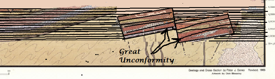
Minnemooseus Member Posts: 3945 From: Duluth, Minnesota, U.S. (West end of Lake Superior) Joined: Member Rating: 10.0 |
So, here's the diagram from Faith's original post.
Faith, how flat is the Great Unconformity? 1) I think you may be reading too much into a diagram that is (hopefully) a rough approximation of reality. 2) What that diagram does show, is that the Great Unconformity (nonconfromity) has itself been tilted and faulted after the deposition of the preCambrian sediments. You are getting a departure from (more or less) flatness and horizontality because of tectonic deformation. Moose
|
|||||||||||||||||||||||||||||||||||||||||||
|
Minnemooseus Member Posts: 3945 From: Duluth, Minnesota, U.S. (West end of Lake Superior) Joined: Member Rating: 10.0 |
I say "But it's not flat...
Good summary of why it's an erosional unconformity and not a thrust fault, but... I would like to see support references for the first two of the above quoted. Moose
|
|||||||||||||||||||||||||||||||||||||||||||
|
Minnemooseus Member Posts: 3945 From: Duluth, Minnesota, U.S. (West end of Lake Superior) Joined: Member Rating: 10.0 |
I'm sensing a degree of bogusity creeping into this discussion. 1) I point out that there is a large vertical exaggeration in that diagram (it even says "vertical scale greatly exaggerated" in the lower left corner). The diagrams vertical dimension is about 14,000 feet, while the (unstated) horizontal dimension is probably several hundreds of miles. 2) The basin is NOT a big (14,000 foot) depression waiting to be filled. Rather, it is a shallow depression which is further subsiding as deposition happens. I would guess that at any point in time, the slope of the deposition surface is actually quite close to horizontal. 3) In the Silurian and Devonian units, the "horizontal" lines of the block pattern are not necessarily representing the bedding planes, especially at the tops of the units. To interpret those lines as bedding would imply that the tops of the Silurian and Devonian units are angular unconformities, when in reality (I strongly suspect) they are conformable contacts (gradational contacts?). Bottom line - I think the bedding of the various units were originally essentially horizontal. Deviations from horizontal are results of post sedimentation deformation. Actually, both sedimentation and deformation are simultaneous processes. Moose Edited by Minnemooseus, : Change subtitle.
|
|||||||||||||||||||||||||||||||||||||||||||
|
Minnemooseus Member Posts: 3945 From: Duluth, Minnesota, U.S. (West end of Lake Superior) Joined: Member Rating: 10.0 |
Well, I think that Moose is right on this. I erred in comparing the locations. And the fact that the diagram shows ages of rocks rather than rock types or formations is a clue. However, I would like to say that I was mainly looking at the variable thicknesses of the units and how they would sag into the basin as they dewatered. First of all, I consider myself a contender for the title of "least competent geologist to have graduated from a reputable university geology department". But I do think what competence I have achieved, is to well recognize my limited competence (and perhaps also others limited competences). Much respect to herebedragons (he has done a lot of good postings), but I do think he sometimes tends to make statements a bit beyond his competence. It's easy to find flaws in creationist reasoning - What I chose to more pursue is to question some responses from the science side. I really don't like seeing dubious rebuttals to creationists. In my original "Bogusity alert" message, I was concerned about overly grand conclusions from A DIAGRAM. Geology diagrams tend to be simplified illustrations (and non-geologists tend to not know or think about that common thing "vertical exaggeration"). I wasn't even thinking about the difference between rock stratagraphic units and time stratagraphic units. Anyway, there may well be some diagenetic (dewatering) sagging, but I think the bulk of the sagging is the basin development itself. For whatever it's worth: Michigan Basin - Wikipedia Tracking down a Michigan map having a scale, it appears that the Michigan basin is about 150 to 200 miles across. That would make the horizontal dimension of:
to be something c. 100 miles, with a basin depth of c. 3 miles. C. 3 miles vertically and c. 50 miles horizontal would be the ratio, or a vertical exaggeration of c. x15. So, reduce the vertical dimension to c. 1/15th to get a more realistic view of the basin. Not much dip there really. ABE - (more or less) true scale image:
Moose Edited by Minnemooseus, : ABE: Added true scale image.
|
|||||||||||||||||||||||||||||||||||||||||||
|
Minnemooseus Member Posts: 3945 From: Duluth, Minnesota, U.S. (West end of Lake Superior) Joined: Member Rating: 10.0 |
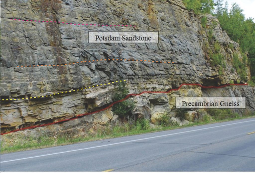
In this picture I'm seeing excactly what HBD is seeing: steeper inclinations of the bedding as we go down the left side of the picture.
It's really hard to say for sure, but my impression is the the sediments are shallow dipping into the face (dipping away from the road). Also, is there a subtle bend in the rock face and road at the center of the photo??? Are we seeing a apparent dip change where there is no real dip change??? Third, you realize that the left side of the rock face is significantly closer to the camera than the right side of the face. This, in itself, would cause the left side bedding to appear to be thicker. In all, I think a lot of grand observations and interpretations are being done on a photo. If you were actually there looking at the rocks, would it be discovered that the dips and thicknesses are actually much more uniform??? Moose
|
|||||||||||||||||||||||||||||||||||||||||||
|
Minnemooseus Member Posts: 3945 From: Duluth, Minnesota, U.S. (West end of Lake Superior) Joined: Member Rating: 10.0
|
Here's the image again. The jog upward in the red line is the portion above the letters "P" through "m" in "Precambrian":
I don't follow the relevance of that detail, but that portion of the red line is flat out wrong. It should be pretty much straight across. Any "jog(s)" there are much more minor. Moose
|
|||||||||||||||||||||||||||||||||||||||||||
|
Minnemooseus Member Posts: 3945 From: Duluth, Minnesota, U.S. (West end of Lake Superior) Joined: Member Rating: 10.0
|
And as Moose stated earlier, the layers have the appearance of dipping downward away from the rock face, so the tilt isn't exclusively left-to-right. There are two variations of the "dip" concept, true dip and apparent dip. If a geologist is talking about "dip", s/he is referring to true dip. Now, dip is the slope (and, to be complete, also the slope direction) of a planar geologic feature. We have been talking about bedding, but a metamorphic foliation is another type of planar feature. To be able to determine the true dip of a feature requires some variety of 3 dimensional exposure. If all you have is a 2 dimensional exposure (which our road-cut photo essentially is), all you can see is an apparent dip. An apparent dip is probably less than the true dip. Indeed, it is possible to have a horizontal apparent dip, and at the same time, a vertical true dip. I have seen bedding exposed on a flat horizontal surface. Without somehow having a third dimension, it is impossible to determine the amount of dip. In the photo, the true dip appears to be fairly shallow and leftward into the rock face. But it is hard to tell from just a photo. But, the bedding lines you see on the rock face only show an apparent dip, which is less than the true dip. In the geological business, a dip has two components, orientation and slope. It is commonly mapped and stated as "strike and dip". The "strike" is the compass bearing of a horizontal line on the bedding face. The "dip" is the slope at a right angle to the strike. A dip could also be stated at a slope measurement and the slope direction. On a geologic map, the dip symbol is a squat "T", probably with a number. The top line of the "T" shows the strike direction and the bottom line of the "T" shows the dip direction. A number will indicate the degrees of slope of the dip. There are also special symbols for horizontal bedding, vertical bedding, and overturned bedding. Foliation dip symbols are different. Bottom line - There is only one true dip at a given location. Any other dips seen are only apparent dips. And on a more vulgar note, there is a special technique for determining the dip direction of near horizontal bedding. It's called the "piss on it" method. Pouring your liquid of choice on the bedding surface, the direction the liquid runs is the dip direction. Moose BTW, did you know that Firefox recognizes "exfoliation" as a correct spelling, but "foliation" as an incorrect spelling.
|
|||||||||||||||||||||||||||||||||||||||||||
|
Minnemooseus Member Posts: 3945 From: Duluth, Minnesota, U.S. (West end of Lake Superior) Joined: Member Rating: 10.0 |
Note in this diagram of the Kaibab Monocline that the thicknesses of the strata vary slightly along the length of a layer but do not accumulate more thickly on the horizontal parts. I don't know if this is a significant issue, but I must stress the "this diagram" part. You're over-interpreting things - This is not intended as being a precise rendering of reality. Your thickness variations are probably, at most, some sloppiness in the document drafting. Moose
|
|||||||||||||||||||||||||||||||||||||||||||
|
|
Do Nothing Button
Copyright 2001-2023 by EvC Forum, All Rights Reserved
![]() ™ Version 4.2
™ Version 4.2
Innovative software from Qwixotic © 2024


 (1)
(1)