|

Understanding through Discussion |
|
|
Register | Sign In |
|
QuickSearch
| EvC Forum active members: 63 (9162 total) |
|
| |
| popoi | |
| Total: 916,332 Year: 3,589/9,624 Month: 460/974 Week: 73/276 Day: 1/23 Hour: 0/0 |
| Thread ▼ Details |
|
Suspended Member (Idle past 1463 days)  Posts: 35298 From: Nevada, USA Joined: |
|
Thread Info
|
|
|
| Author | Topic: Evidence that the Great Unconformity did not Form Before the Strata above it | |||||||||||||||||||||||||||||||||||||||
|
edge Member (Idle past 1724 days)  Posts: 4696 From: Colorado, USA Joined: |
Again, the G.U. contact line is REMARKABLY straight and level in all those photos I posted.
And in all of the photos we posted, it was not so straight and level. But certainly you have a point here. What is it? Why do you insist on
NOBODY said "perfect," the standard I'm using is right there in the pictures: THAT is straight and level.
Good, then you agree that erosion can make a rock terrace that is straight and level, because we have shown them to you.
A question though: if this Supergroup was the root of a mountain range a LOOOONG time ago, with that enormous weight over it for millions of years, why is it sedimentary rather than metamorphic rock:?
Who said it was the 'roots' of a mountain range? And how much weight was there? Remember, the Paleozoic section was not on top of it until it had been eroded. Metamorphic grade is dependent upon geothermal gradient It is entirely possible to have low gradients and preserve the original mineralogy and textures to very deep regions.
|
|||||||||||||||||||||||||||||||||||||||
|
edge Member (Idle past 1724 days) Posts: 4696 From: Colorado, USA Joined: |
That has never happened before. Why even mention it?
Because now we are going down another rabbit hole of what is flat and what is smooth, etc. ...
AND I KNOW PLANAR MEANS SMOOTH. Good GRIEF.
Not in the technical sense...
|
|||||||||||||||||||||||||||||||||||||||
|
edge Member (Idle past 1724 days) Posts: 4696 From: Colorado, USA Joined:
|
YOU DID NOT POST ANY PHOTOS OF THE GREAT UNCONFORMITY AT ALL in this recent discussion.
Sure I did. I posted the one of Siccar Point. It's actually a very rough surface, even in two dimensions.
I'm not explaining things again that were clear enough the first hundred timesl.
Okay, let's put it this way... Why do you care that the unconformity surface is so smooth?
YOU in particular have NOT shown me anything that answers the observation of the level flatness in those pictures I posted.
No. I have shown you tilted rocks below a modern unconformity.
You showed naturally flat surfaces and otherwise completely irrelevant images.
Well, they're all natural. What are you talking about?
And although HBD posted some that sort of qualify, none of them is as horizontal and straight as the examples I gave in Message 213
And I recently showed you one exactly the same with no overlying rocks and yet the only explanation is erosion.
THERE WAS A MOUNTAIN RANGE ON TOP OF IT!!! Site after site says it was the "root" of a mountain range.
I suggest you check your references. The metamorphic complex was likely at the root of a mountain range, but the Supergroup, not so much.
|
|||||||||||||||||||||||||||||||||||||||
|
edge Member (Idle past 1724 days) Posts: 4696 From: Colorado, USA Joined:
|
BURIED VALLEYS AND RIVERBEDS ARE TOTALLY IRRELEVANT. You have obviously not grasped the point.
Actually, they are relevant to the point that unconformities are not just smooth planar. ETA: Faith, I detect your level of frustration. But you can fix that. Learn some geology and see how it all comes together. You don't have to shoehorn everything into a young earth and a flood. Edited by edge, : No reason given.
|
|||||||||||||||||||||||||||||||||||||||
|
edge Member (Idle past 1724 days) Posts: 4696 From: Colorado, USA Joined: |
Faith, how about you check out my post Message 286 and tell me if it satisfies your demands. Please tell us what formed that surface as shown if not erosion?
Then check out me post Message 281 and tell me that the rocks under the modern erosional surface are not tilted.
|
|||||||||||||||||||||||||||||||||||||||
|
edge Member (Idle past 1724 days) Posts: 4696 From: Colorado, USA Joined:
|
THAT IS A TOTALLY IRRELEVANT QUESTION. I NOTICED HOW AMAZINGLY STRAIGHT AND LEVEL THEY ARE AND THAT RAISED THE QUESTION HOW A MILLION PLUS YEARS OF EROSION COULD HAVE DONE THAT.
So you are saying that if it were eroded for millions of year it should look different, maybe rougher? So, why should that be?
NATURALLY FLAT AND LEVEL. UNLIKE SCHIST AND TILTED STRATA. SHEESH.
So, tilted strata are not natural? Naturally planar and tilted? ETA: Ah! I think I see now. You are saying that some of these examples are not erosional, but depositional. You know if you weren't so disagreeabe, we might be able to help you with these things.
YOU NEVER READ ANYTHING I WROTE DID YOU?
I try to read everything you write, but it's a lot of work figuring out what you mean. It's not necessary to be angry when someone asks you for clarification. Edited by edge, : No reason given. Edited by edge, : No reason given.
|
|||||||||||||||||||||||||||||||||||||||
|
edge Member (Idle past 1724 days) Posts: 4696 From: Colorado, USA Joined: |
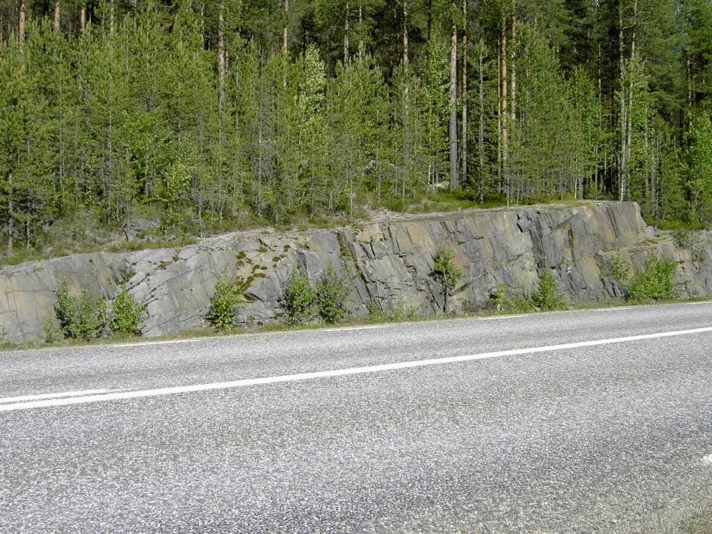
-- That's the sort of formation that is often part of an angular unconformity, and if it was then the upper part washed away and the lower part was then exposed to erosion. Otherwise it was formed by erosion, which IS WHY IT IS NOT STRAIGHT AND LEVEL LIKE MY EXAMPLES IN Message 213 ---
Faith the rock surface is more straight and level than the road in the foreground. You cannot get more 'straight and level'. But have it your way, Faith.
---I can't even see that formation in the distance. ---
That's why I highlighted them with yellow lines. There is also one in the foregound.
|
|||||||||||||||||||||||||||||||||||||||
|
edge Member (Idle past 1724 days) Posts: 4696 From: Colorado, USA Joined: |
I cannot make out the formation in the background.
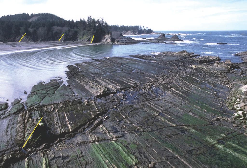
Zoom in on the yellow highlight line in the upper left and you can see the layering in the outcrops.
In this image, the upper contact is smooth and almost flat. The schist has a near vertical, gray, platy schistosity about parallel to the direction of the roadway.
|
|||||||||||||||||||||||||||||||||||||||
|
edge Member (Idle past 1724 days) Posts: 4696 From: Colorado, USA Joined: |
What evidence in this image indicates that the boundary traced by the yellow line was caused by erosion?
The three best pieces of evidence and the ones we have been relying on mostly are: --sedimentary clasts of the lower rock series within the upper --stream channels or karst features cut into the lower series, etc. --the identical appearance of the unconformity surface to the existing surface, along with the lack of any other known process that would form the unconformity surface. Faith's scenario fails to explain all of these. In a more general explanation of unconformities, there are other features such as paleosoils or regolith above the surface and weathering effects below it (I'm pretty sure we have seen evidence of this in the GC). Sometimes there are root systems or other fossil features in the lower sequence (which I may call the footwall from time to time), and things like glacial striations. In some places you might find ejecta from hot springs or geysers.
Faith would like photographic evidence of an angular unconformity at the surface, i.e., one where there's only sky above the unconformity. If I understand her correctly, that's all that's preventing her acceptance that the Grand Unconformity is an erosional surface.
As nearly as I can tell I/we have given her several examples. My most recent being only a couple of posts back (that same picture for the third time, by the way); and actually, the image you include with this post of yours shows a modern surface that would be an unconformity were it buried suddenly by a rise in sea level. Remember, my point in showing the Siccar Point picture is to show that the surfaces are not always 'smooth'. And that location is truly an unconformity.
|
|||||||||||||||||||||||||||||||||||||||
|
edge Member (Idle past 1724 days) Posts: 4696 From: Colorado, USA Joined: |
And this description from Cambrian History of the Grand Canyon Region uses enough technical terms and unfamiliar references as to be indecipherable to many: Put simply, McKee (?) is saying that the surface effects of chemical weathering of rock extend well below the bedrock surface.
quote:The principal points are as follows: 1. Weathering of the Archean rocks has extended downward 10 to 12 feet in many places and as far as 50 feet below the surface in some places. 2. Weathering of Algonkian rocks has been slight, presumably because they are composed of minerals that have already survived at least one cycle of weathering.
Again, put simply, some of the rocks weather more slowly than others, probably due to mineralogy and how broken up they are.
etc...
To a trained person, these points are clear pretty clear. I'm glad someone is interested enough to ask.
etc... What does it mean where it says that weathering has extended downward 10 to 12 feet? Does that mean that there's a dip in the surface of 10 to 12 feet. Of is that what it's referring to when it uses the term "weathered zone", and that the effects of weathering can be observed to a depth of 10 to 12 feet below the contact surface?
If it was eroded away, yes, the surface would depress by that amount. However, in this instance, it means that the chemical effects of weathering affect the bedrock to that depth but the rock is still intact.
|
|||||||||||||||||||||||||||||||||||||||
|
edge Member (Idle past 1724 days) Posts: 4696 From: Colorado, USA Joined: |
I think it would be reasonable for Faith to ask for evidence that the strata are tilted.
Sometimes it would be good for someone to ask for an explanation. In this particular case, it could get into kind of a time-consuming, technical discussion relying on some visual interpretation that could be simply denied (of course, that never happens around here). But if someone really wants to know...
|
|||||||||||||||||||||||||||||||||||||||
|
edge Member (Idle past 1724 days) Posts: 4696 From: Colorado, USA Joined: |
I am, as I said, gradually reading and responding through the thread. Your last three posts contain precisely what I suggested might be helpful a little earlier this morning, thank you. For this particular image, could you clarify what in the image indicates that the layers are tilted?
Not having been there, I'm not exactly sure what the rock type is, but I think you can see the layering which tilts steeply to the left toward the sea. The large flat surfaces face toward the sea and stand at about a 50 degree angle. Those surfaces are cut off at the top where a soil is developed and humans have constructed a lighthouse. On the lower elevations, at wave level, you can see another flat bench starting to develop. Someday if it is uplifted, it will also develop a soil and someone will build on it. The current lighthouse, of course, will be eroded away... Edited by edge, : No reason given.
|
|||||||||||||||||||||||||||||||||||||||
|
edge Member (Idle past 1724 days) Posts: 4696 From: Colorado, USA Joined: |
Far as I know images of how rock erodes aren't available.
So images in Message 312 and Message 284 are not eroded? Not a clue?
|
|||||||||||||||||||||||||||||||||||||||
|
edge Member (Idle past 1724 days) Posts: 4696 From: Colorado, USA Joined: |
So you think the basement rocks of the G.U. were once like the Great Salt Lake? And all that schist and/or tilted strata was buried beneath the surface?
Personally, I think it looked like this Message 257, but you haven't really told me if the surface is smooth or rough in that picture. And then, there is Message 281 which you have not yet addressed.
|
|||||||||||||||||||||||||||||||||||||||
|
edge Member (Idle past 1724 days) Posts: 4696 From: Colorado, USA Joined: |
A question for Faith.
So, are all unconformities prior to the modern one non-erosional?
|
|||||||||||||||||||||||||||||||||||||||
|
|
Do Nothing Button
Copyright 2001-2023 by EvC Forum, All Rights Reserved
![]() ™ Version 4.2
™ Version 4.2
Innovative software from Qwixotic © 2024


 (1)
(1)