|

Understanding through Discussion |
|
|
Register | Sign In |
|
QuickSearch
| Thread ▼ Details |
|
Suspended Member (Idle past 1471 days)  Posts: 35298 From: Nevada, USA Joined: |
|
Thread Info
|
|
|
| Author | Topic: Evidence that the Great Unconformity did not Form Before the Strata above it | |||||||||||||||||||||||||||||||||||||
|
Admin Director  Posts: 13038 From: EvC Forum Joined: Member Rating: 2.1 |
edge writes:
This one is especially interesting to me because it has two generations of wave cut terraces: the large one with the lighthouse on it, and several more recent ones down at the wave line; all indicating uplift of the shoreline at this location near Singley Creek in California. I am, as I said, gradually reading and responding through the thread. Your last three posts contain precisely what I suggested might be helpful a little earlier this morning, thank you. For this particular image, could you clarify what in the image indicates that the layers are tilted?
|
|||||||||||||||||||||||||||||||||||||
|
Admin Director Posts: 13038 From: EvC Forum Joined: Member Rating: 2.1 |
edge writes: Oh good grief. Why is this so difficul?. It wouldn't erode flat if it was tilted, but even if it was tilted it would be nothing like tilted STRATA.
But it is tilted. Do you know how I can tell? Do you think I would have shown you this picture if I didn't check? I think it would be reasonable for Faith to ask for evidence that the strata are tilted.
|
|||||||||||||||||||||||||||||||||||||
|
Admin Director Posts: 13038 From: EvC Forum Joined: Member Rating: 2.1 |
Faith writes: You've given a series of straw man answers. Nothing but denial and evasion. But what on earth could I possibly have expected here anyway? Masters of obfuscation. Edge has provided what you requested, evidence of eroded tilted strata at the surface. If you actually wanted something different then could you please describe it?
|
|||||||||||||||||||||||||||||||||||||
|
Admin Director Posts: 13038 From: EvC Forum Joined: Member Rating: 2.1 |
Faith writes: However, you came up with some examples so you win. This isn't a case of winning or losing, just a case of one point getting across from one side of the debate to the other, in this case that eroded tilted strata exist at the surface. I am, as I have said several times, responding as I read along, so I don't know where the discussion went after this, but we should be clear about what you're saying. Does this mean that there's now agreement that the Grand Uncomformity is an eroded surface?
|
|||||||||||||||||||||||||||||||||||||
|
Admin Director Posts: 13038 From: EvC Forum Joined: Member Rating: 2.1 |
herebedragons writes: I'm not sure this is the situation exactly. I am thinking that she is suggesting the the slip - folding is what caused the "perfectly" planar surfaces, rather than erosion. It is not a scenario you can find in any textbook, so it is something I was thinking about drawing up to show why it's not a feasible mechanism. I think visual aids are making extremely valuable contributions to the discussion. If you can begin illustrating the mechanism Faith is describing, that could be very helpful.
|
|||||||||||||||||||||||||||||||||||||
|
Admin Director Posts: 13038 From: EvC Forum Joined: Member Rating: 2.1 |
Faith writes: And I believe I do look at the big picture. Everybody else is looking at minuscule amounts of erosion between layers in my experience. People may be wondering what you mean by this, particularly since the Grand Unconformity has been described a number of times as potentially representing a couple miles of missing material.
|
|||||||||||||||||||||||||||||||||||||
|
Admin Director Posts: 13038 From: EvC Forum Joined: Member Rating: 2.1 |
Faith writes: I'm not explaining things again that were clear enough the first hundred times. I am asking all participants to repeat clarifications and explanations as many times as necessary. About your claim of "the first hundred times" you explained things, the evidence shows you claiming many times that you've already explained something, but actual explanations seem much more rare.
|
|||||||||||||||||||||||||||||||||||||
|
Admin Director Posts: 13038 From: EvC Forum Joined: Member Rating: 2.1 |
Faith writes: THE FRUSTRATION COMES FROM PEOPLE NOT READING WHAT I WRITE AND NOT THINKING AND IMPUTING RIDICULOUS NOTIONS TO ME. Please leave moderation to the moderators. If you have specific complaints or issues please take them to the Report Discussion Problems Here 4.0 thread. I'm requesting that all participants clarify and explain as often as necessary.
|
|||||||||||||||||||||||||||||||||||||
|
Admin Director Posts: 13038 From: EvC Forum Joined: Member Rating: 2.1 |
Faith writes: You aren't understanding the simplest most obvious things and I can't stand it any more. In case it hasn't been clear from my previous messages, I'd like to encourage responses that seek to clarify and explain rather than blame.
|
|||||||||||||||||||||||||||||||||||||
|
Admin Director Posts: 13038 From: EvC Forum Joined: Member Rating: 2.1 |
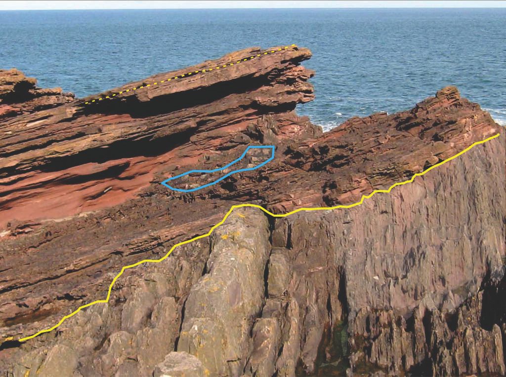
edge writes: Zoom in on the yellow highlight line in the upper left and you can see the layering in the outcrops. Does Faith know about Ctrl-+, etc.?
|
|||||||||||||||||||||||||||||||||||||
|
Admin Director Posts: 13038 From: EvC Forum Joined: Member Rating: 2.1 |
Faith writes: The "upper sequence" being the horizontal strata above the vertical? But it certainly IS that battered: those rocks are barely a shadow of their former selves, nothing left but splinters basically. And surely there was once a huge stack of strata above them too, just as in the GC, long since destroyed by tectonic and other forces. And do try to remember: I don't think of each bedding plane as having been exposed for any great period of time. I'd like to try to clarify for everyone what you're saying. You seem to be saying that the exposed boundary at Siccar Point used to be straighter, in the past following a line closer to the one I've drawn over the actual boundary:
Battering by the fierce weather near the sea has altered this boundary over time, giving it the shape actually shown in the photograph and traced by the squiggly yellow line:
To be clear, you're not saying that feet of rock have been eroded away from this exposed cliff face, eradicating the rock where the boundary was straight, and exposing a previously buried part of the boundary from deeper within the cliff face that is much less flat. That's not what you're saying. You're saying that the forces of weathering actually changed the shape of the boundary itself. Please correct as necessary.
|
|||||||||||||||||||||||||||||||||||||
|
Admin Director Posts: 13038 From: EvC Forum Joined: Member Rating: 2.1 |
Faith writes: I think so. Because people could potentially spend a lot of time responding to what they believe to be your position, it would be very helpful if you could clearly identify when we've accurately understood you. Trying again, your position is that the exposed cliff face that we see today at Siccar Point that shows a very uneven boundary between layers was once deeply buried inside the cliff face, and that before a great deal of rock was eroded away by severe weathering that the boundary that used to be visible was much more straight. And to be clear about what you're not saying, your position is not that we're looking at pretty much the same rock today (the same cliff face) at Siccar Point that we were looking at a couple hundred years ago, but that it was much straighter then. Edited by Admin, : Grammar.
|
|||||||||||||||||||||||||||||||||||||
|
Admin Director Posts: 13038 From: EvC Forum Joined: Member Rating: 2.1 |
Faith writes: If I'm getting you, yes, I'm saying that the presently "exposed cliff face" was eroded after being exposed. But what you've just said, that the cliff face was eroded after being exposed, isn't what people are taking issue with. If that's all you were really saying then everyone would agree with you because every exposed surface is always being eroded, it only being a matter of degree. We're trying to understand what you think happened to transform this from a couple hundred years ago:
Into this today (ignore the blue outlined area):
There are two options:
Or is it something else. Please let us know.
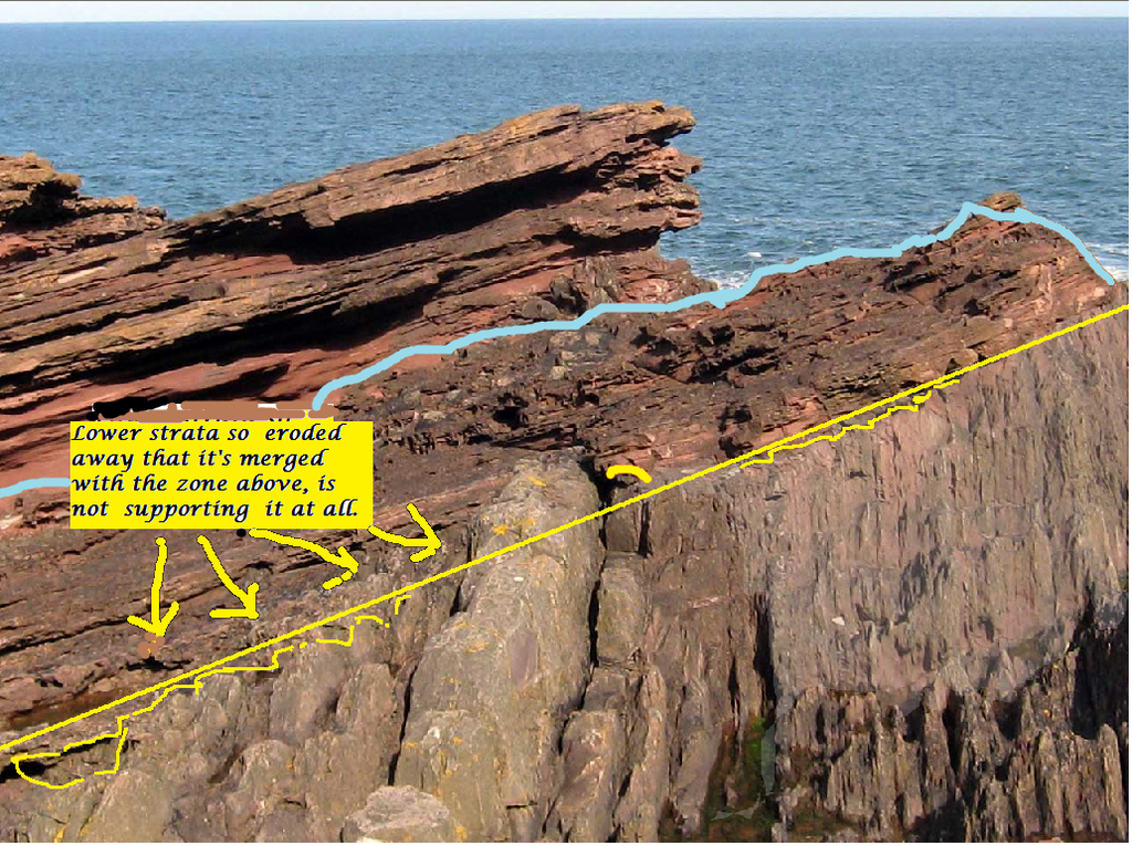
But as I was looking at your version of the picture you marked with the straight line I began to doubt that edge had identified the lower strata correctly anyway. Some of it looks like it belongs in the eroded zone above it. But even if the yellow line were redrawn as you would like, it would still be uneven, right? PS: Edge - Are you deleting photos from PhotoBucket that you've linked to from your messages? And me, too?
|
|||||||||||||||||||||||||||||||||||||
|
Admin Director Posts: 13038 From: EvC Forum Joined: Member Rating: 2.1 |
Faith writes: The drawing I posted I believe represents accurately what was actually there: Distinct upper horizontal and lower vertical sections with a straight contact line. Is this the drawing you mean:
The contact point between the upper and lower layers appears very similar to Edge's photo, fairly straight to the right, fairly uneven to left:
The diagram was drawn from a different angle than the photo, accounting for some of what appear to be differences but probably aren't. Here's an image with some people in it to give you some perspective:
To explain edge's photo of the irregular contact line... Both the diagram and Edge's photo show irregular contact lines, so you need to explain both.
...I figure the upper section was partly eroded away from the lower, could be a matter of inches rather than feet but I'm not sure of the scale, exposing the upper surface of the lower strata to weathering which has made it irregular over the last couple hundred years. ABE: So, rereading, I think your option 2 is closest but it needs the exposure of the upper surface of the cliff face brought about by erosion of the upper section. I'm still not sure what you're saying. Do you mean that the lower layer at the boundary was eroded more than the upper layer, and that the boundary is still straight, it's just that there's now the appearance of being uneven? Here's the image without the yellow line - it might help because it gives a better idea of which layers stick out from the cliff face more than others:
Edited by Admin, : Clarify last para.
|
|||||||||||||||||||||||||||||||||||||
|
Admin Director Posts: 13038 From: EvC Forum Joined: Member Rating: 2.1 |
Faith writes: I spent a little time on that photo and came up with the following: the only part of the lower section that remains above the straight line you drew is the small piece to the right of the dike. My own squiggly yellow line falls below yours. I also outlined in lt. blue the zone that looks more like erosion than like either of the strata sections.
I think you're saying that your squiggly yellow lines represent what you believe to be erosion that has taken place since the time of Hutton. And in Message 424 you said:
To explain edge's photo of the irregular contact line I figure the upper section was partly eroded away from the lower, could be a matter of inches rather than feet but I'm not sure of the scale, exposihg the upper surface of the lower strata to weathering which has made it irregular over the last couple hundred years. ABE: So, rereading, I think your option 2 is closest but it needs the exposure of the upper surface of the cliff face brought about by erosion of the upper section. Since you say my option 2 was closest, here it is:
Admin's option 2 writes:
So it looks like we have an answer now. You're proposing that the unconformity boundary in the Hutton diagram became less straight over time because severe weather deformed it, thereby rebutting Edge's claim that the boundary was originally uneven.
|
|||||||||||||||||||||||||||||||||||||
|
|
Do Nothing Button
Copyright 2001-2023 by EvC Forum, All Rights Reserved
![]() ™ Version 4.2
™ Version 4.2
Innovative software from Qwixotic © 2024