|

Understanding through Discussion |
|
|
Register | Sign In |
|
QuickSearch
| EvC Forum active members: 66 (9164 total) |
|
| |
| ChatGPT | |
| Total: 916,480 Year: 3,737/9,624 Month: 608/974 Week: 221/276 Day: 61/34 Hour: 0/4 |
| Thread ▼ Details |
|
Suspended Member (Idle past 1466 days)  Posts: 35298 From: Nevada, USA Joined: |
|
Thread Info
|
|
|
| Author | Topic: Evidence that the Great Unconformity did not Form Before the Strata above it | ||||||||||||||||||||||||
|
New Cat's Eye Inactive Member |
The larger circled area shows the general disturbance that occurred in the stack at that point, and the smaller circled area shows where the layer itself was broken. These are clear indicators that the layer was already formed when the disturbance occurred that caused the left side to sag. Formed enough to break but soft enough to sag. You're assuming it was just one event when they could have been separate events. The layer could have "sagged" while it was being deposited and then later after it solidified the circled parts broke off.
|
||||||||||||||||||||||||
Faith  Suspended Member (Idle past 1466 days) Posts: 35298 From: Nevada, USA Joined: |
The examples of sag or drape that are described in the quote are consistent with what I've been saying about this occurring with soft but formed layers but not with sediments depositing in the "fluid" or "loose" condition.
Then where is the evidence that the sagging is tectonic? It may not be in the case described in your quote, it may be the result of sedimentary processes themselves as is claimed. The important point for me at the moment is just that drape occurs to FORMED BUT SOFT ROCKS, not newly deposited sediments.
But it's all moot anyway. You are still talking about sediments in a sedimentary environment, not rocks in a tectonic environment.
Actually I've consistently had in mind FORMED LAYERS THAT ARE SOFT ENOUGH TO DEFORM AROUND OBJECTS, neither sediments nor rocks. Soft enough to deform, hard enough to maintain their shape as layers. The underlying rocks, however, are all apparently lithified, metamorphosed etc. and, I'm arguing, probably tectonically pushed upward.
Which is the whole point of this exercise: the Great Unconformity formed the base for sedimentation during Tapeats time. And in many places provided an extraordinarily level platform for the purpose.l.. ...OR the GU formed after the Tapeats was already there.
|
||||||||||||||||||||||||
|
Faith Suspended Member (Idle past 1466 days) Posts: 35298 From: Nevada, USA Joined: |
The fact that it's a FORMED LAYER that had to have sagged AFTER ITS FORMATION. As I've said five billion times already.
But you said they were soft. I must have said "FORMED AS RECOGNIABLE LAYERS BUT SOFT ENOUGH TO DEFORM" at least 9422 times by now. One time I don't say the whole phrase and you forget that?
But be careful about that idea I "conceded" what you say. All I said was that I don't care and it doesn't interest me whether sediments can deposit on a slope or not, I don't regard that as "draping" or anywhere near the basis for a stack of draped layers.
But if they were deposited on a slope then it is a sedimentary environment. I don't know of any other possibility. If the gneiss is 'intruded', I presume it would be along faults. Where are those faults? If those layers were 'formed', why weren't the layers above them 'formed' also? They should show some faults extending from the gneiss into the layers. Maybe you could explain your 'intruded' mechanism a little better. 1. I don't understand your remark about its being a sedimentary environment if they were deposited on a slope. Of course I don't think they were, I'm arguing they were already there when the underlying rocks pushed up into them, already there in a FORMED BUT SOFT ENOUGH CONDITION TO DEFORM or drape around the intruding rock. 2. If faults are a necessity and you don't see any faults I guess I'm stuck with just the impression of the draped sediments as my evidence for the intrusion of the underlying rocks into the Tapeats, and you reject that, so perhaps the argument is at an end for now. 3. bI don't know what you mean by asking why layers above the formed layers weren't formed. I assume they all were formed into layers, which is clearly illustrated in the drawings, don't know how I gave a different impression. Edited by Faith, : No reason given.
|
||||||||||||||||||||||||
|
Faith Suspended Member (Idle past 1466 days) Posts: 35298 From: Nevada, USA Joined: |
The plastic strata in the McKee diagrams was deformed into draping by being pushed up by the underlying rock.
Fine. Show us the mechanism for being 'pushed up'. Show us the faults or shears associated with this tectonic deformation. ABE: Oh, just to clarify, that would be 'evidence'. As I say in my previous post to you, if faults are the evidence you need then perhaps the argument is over for now, since my main evidence is the draping of the sandstone layers, and since you reject that as evidence that's that for now. Perhaps some other evidence will show up. **Back later** Edited by Faith, : No reason given.
|
||||||||||||||||||||||||
|
JonF Member (Idle past 190 days) Posts: 6174 Joined: |
Those are overhangs, not separations. The layers are resting directly on each other, whether or not you they are neatly or messily stacked
|
||||||||||||||||||||||||
|
JonF Member (Idle past 190 days) Posts: 6174 Joined: |
Sedimentary environments can't be sloped? Tell all the ponds and lakes and oceans they're doing it wrong.
Oops, I forgot that you don't define a sedimentary environment as a place where sedimentation is taking place but rather as something else altogether.
|
||||||||||||||||||||||||
|
edge Member (Idle past 1728 days)  Posts: 4696 From: Colorado, USA Joined: |
It may not be in the case described in your quote, it may be the result of sedimentary processes themselves as is claimed. The important point for me at the moment is just that drape occurs to FORMED BUT SOFT ROCKS, not newly deposited sediments.
That is what we would call soft sediment deformation. So, basically, no matter how it happened, you have a sedimentary environment with sands being deposited on an irregular surface. I don't care if it happened on a sloping surface, in cross beds, or as soft sediment deformation - it is sedimentary. Not tectonic.
Actually I've consistently had in mind FORMED LAYERS THAT ARE SOFT ENOUGH TO DEFORM AROUND OBJECTS, neither sediments nor rocks.
Makes no difference: they are soft sediments. They are not rocks until lithified. They are, however, strata.
Soft enough to deform, hard enough to maintain their shape as layers. The underlying rocks, however, are all apparently lithified, metamorphosed etc. and, I'm arguing, probably tectonically pushed upward.
But without evidence, yes.
And in many places provided an extraordinarily level platform for the purpose.l..
For which you have not found any evidence, yet.
...OR the GU formed after the Tapeats was already there.
|
||||||||||||||||||||||||
|
edge Member (Idle past 1728 days) Posts: 4696 From: Colorado, USA Joined: |
1. I don't understand your remark about its being a sedimentary environment if they were deposited on a slope.
If sediments are being deposited, then it is a sedimentary environment.
Of course I don't think they were, I'm arguing they were already there when the underlying rocks pushed up into them, already there in a FORMED BUT SOFT ENOUGH CONDITION TO DEFORM or drape around the intruding rock.
But there is no evidence for intrusion.
2. If faults are a necessity and you don't see any faults I guess I'm stuck with just the impression of the draped sediments as my evidence for the intrusion of the underlying rocks into the Tapeats, and you reject that, so perhaps the argument is at an end for now.
To get the amount of relief shown in the McKee diagrams, a fault should be obvious.
3. bI don't know what you mean by asking why layers above the formed layers weren't formed. I assume they all were formed into layers, which is clearly illustrated in the drawings, don't know how I gave a different impression.
But in this case the deformation does not extend into the overlying rocks. Even in your 'deformed area' the bedding passes through with almost no offset.
|
||||||||||||||||||||||||
|
edge Member (Idle past 1728 days) Posts: 4696 From: Colorado, USA Joined: |
Those are overhangs, not separations. The layers are resting directly on each other, whether or not you they are neatly or messily stacked
Exactly correct. And this argument was predictable. On another thread, we spent a number of pages debating what part of the outcrop was in shadow and what part not... So tedious...
|
||||||||||||||||||||||||
|
Admin Director  Posts: 13023 From: EvC Forum Joined: Member Rating: 1.9 |
Faith writes: It's frustrating to keep being dragged back to that basic argument while the issues that concern me get ignored. Say you really, really want to build a house. You're really anxious to get on with things and build that house, but people keep holding you up and bothering you with details that you don't care about like laying a foundation. Naturally you find it very frustrating, but only until you come to understand the importance of laying a foundation. It's the same here. You keep getting dragged back to basic points because they're the foundation for the issues you're so concerned about. Naturally you find it very frustrating, but they're as important to your issues as a foundation is to a house.
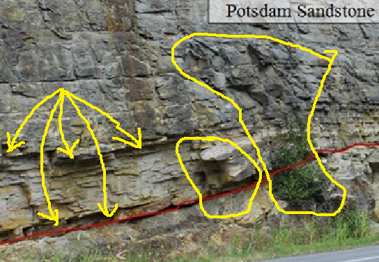
In this case I've marked some indicators of the deformation of the rocks. The arrows point to the contacts between the layers, showing that the layers are separated from each other, not laid neatly one on top of the other as you see in fresh deposition; and I circled places where the rocks broke at the edge, or "hinge" if you will, of the area to the left that sags away from the central area. This is a road cut. Any separation of layers and broken rocks are a result of cutting and/or blasting the rock to make the road cut and of any subsequent weathering due to wind, rain, snow and freeze/thaw cycles.
The larger circled area shows the general disturbance that occurred in the stack at that point,... The larger circled area shows a bush and discolored rock with a more irregular surface, but that's a function of making the road cut. There's nothing to indicate a tectonic disturbance,
...and the smaller circled area shows where the layer itself was broken. The smaller circled area shows rock that was broken when the road cut was created or maybe by later weathering, and a shadow. Again, nothing to indicate a tectonic disturbance. So there's no evidence that tectonic activity changed the tilt of the layers, so the original question remains. What leads you to believe the layers must originally have been horizontal?
|
||||||||||||||||||||||||
|
Faith Suspended Member (Idle past 1466 days) Posts: 35298 From: Nevada, USA Joined: |
Those are overhangs, not separations. The layers are resting directly on each other, whether or not you they are neatly or messily stacked Speaking of cheesy ad hoccism... How you know this is beyond me but I don't feel like fighting it. It really doesn't make any difference to my point because clearly these are disturbed contacts and represent the overall disturbance to the rock we've been talking about. Layers don't deposit with overhangs, that's evidence of displacement after deposition just as separation would be. Evidence for this disturbance is the nice tight contacts between layers above these. Obviously these lower layers collapsed while formed but soft just as I've argued, whether the deformation produced overhangs or separation at the contacts. Strata don't just messily deposit, don't make sloppy contacts. Here's the original again. Note the very tight neat contacts between layers above the ones we are discussing.
Edited by Faith, : No reason given.
|
||||||||||||||||||||||||
|
ThinAirDesigns Member (Idle past 2395 days) Posts: 564 Joined: |
OMG Faith. You do realize that the cut in that picture was jack hammered into swiss cheese and then dynamited into oblivion?
|
||||||||||||||||||||||||
|
Faith Suspended Member (Idle past 1466 days) Posts: 35298 From: Nevada, USA Joined: |
These illustrate draping. Drag folds too.
Drag would suggest shearing. So, where is the evidence for shearing. Well, there are the drag folds themselves for evidence....
But let's look at the schematics a little closer. Do you see in image 'g', that gravels are found adjacent to the Archean body? Gravels are usually found close to their source, so could it be that the Archean hill is the source of the gravels? I would suppose so, and since they appear to be a bit of a distance from the hill and embedded in the sandstone it seems very likely they were sheared off that hill during the intrusion.
Now look at image 'a'. See the dike that is cut off by the unconformity? Do you realize that, according to Steno, that means the dike is older than the unconformity? So, could it be that there was some igneous activity before the Cambrian Tapeats deposition? How does that comport with your scenario of only one igneous event at the end of the geological record. Of is Steno out to lunch on this one? You know what's odd about that? The fact that there is no lava spill indicated at the "unconformity," i.e. the surface of the hill, such as occurred at the top of the Grand Staircase over the Claron, and in other parts of the Grand Canyon. Here it is illustrated as abruptly cut off. I'd guess it was all part of the same tectonic event that created the GU everywhere, and that there WAS shearing involved in the push of the underlying rock up into the Tapeats, which displaced the upper part of the dike. In this case I suppose it should be found somewhere in the Tapeats. Just a guess but it IS odd how it's just cut off like that. I guess you'd say it was eroded away over millions of years before the Tapeats deposited?
Now on to image 'c'. do you see the little squiggly lines in the Archean rocks close to the unconformity? Do you see how they fan away from the high point of the 'hill'? do you think McKee just accidentally drew them that way? To a geologist this pattern indicates downhill 'creep' of layers that were once vertical. We see that in weathering of rocks on a hillside where there is plenty of water and soil development. It was one of Hutton's first observations of the rocks just below the soil of his farm. I don't discount anything on such a diagram and I wondered what those lines indicate. So they indicate VERTICAL STRATA? Into which water has seeped, deforming the layers on the sides? How about water from the already-deposited but formed and still soft and damp sandstone it intruded up into perchance?
In image 'b', as PaulK has mentioned, there is an assymetric draping of sediments coming off the two Archean high points. Do you know what this means? I'd suggest perhaps it means an assymetrical entry of the intruding rock myself, causing asymmetrical drag.
Now, my points are that the drawings indicate a surficial environment for deposition of the Tapeats; and also that McKee put enough detail into the diagrams that I would be shocked to find out that he missed a bunch of faults that uplifted each one of these Archean high points. Seems like you've made a decent case for your view. I still like mine of course and continue to view the draping sandstone as my best evidence, but I also like that embedded gravel for evidence too.
|
||||||||||||||||||||||||
|
Faith Suspended Member (Idle past 1466 days) Posts: 35298 From: Nevada, USA Joined: |
OMG Faith. You do realize that the cut in that picture was jack hammered into swiss cheese and then dynamited into oblivion? Hold your horses, I'm coming to that eventually. Hint: Those layers on the left were SOFT when they sagged into that position. The road cut was made in lithified rock. ABE: Unfortunately I need a break and I suppose there will be another ton of stuff to answer when I get back. Edited by Faith, : No reason given.
|
||||||||||||||||||||||||
|
edge Member (Idle past 1728 days) Posts: 4696 From: Colorado, USA Joined: |
Well, there are the drag folds themselves for evidence....
Ah, good. You are using the presence of drag folds as evidence that they are drag folds.
I would suppose so, and since they appear to be a bit of a distance from the hill and embedded in the sandstone it seems very likely they were sheared off that hill during the intrusion.
Then you can provide evidence for shearing, right?
You know what's odd about that? The fact that there is no lava spill indicated at the "unconformity," i.e. the surface of the hill, such as occurred at the top of the Grand Staircase over the Claron, and in other parts of the Grand Canyon. Here it is illustrated as abruptly cut off.
Well, if that were the case, the it would show that the dike is younger than the unconformity, right? After all, you do understand Steno's principles, don't you?
I'd guess it was all part of the same tectonic event that created the GU everywhere, and that there WAS shearing involved in the push of the underlying rock up into the Tapeats, which displaced the upper part of the dike. In this case I suppose it should be found somewhere in the Tapeats. Just a guess but it IS odd how it's just cut off like that.
And, of course, you can do that?
I don't discount anything on such a diagram and I wondered what those lines indicate. So they indicate VERTICAL STRATA? Into which water has seeped, deforming the layers on the sides? How about water from the already-deposited but formed and still soft and damp sandstone it intruded up into perchance?
So, you think it happened during sometime while the Tapeats still consisted of soft sediments?
I'd suggest perhaps it means an assymetrical entry of the intruding rock myself, causing asymmetrical drag.
And, of course you have some kind of evidence for the kinematics of that intrusion? Can you tell us which direction the older rocks were moving?
Seems like you've made a decent case for your view. I still like mine of course and continue to view the draping sandstone as my best evidence, but I also like that embedded gravel for evidence too.
What is 'embedded gravel'? And perhaps you can show us your evidence that it was emplaced by shearing? Edited by edge, : No reason given.
|
||||||||||||||||||||||||
|
|
Do Nothing Button
Copyright 2001-2023 by EvC Forum, All Rights Reserved
![]() ™ Version 4.2
™ Version 4.2
Innovative software from Qwixotic © 2024