|

Understanding through Discussion |
|
|
Register | Sign In |
|
QuickSearch
| Thread ▼ Details |
|
Suspended Member (Idle past 1464 days)  Posts: 35298 From: Nevada, USA Joined: |
|
Thread Info
|
|
|
| Author | Topic: The Geological Timescale is Fiction whose only reality is stacks of rock | |||||||||||||||||||||||||||||||||
|
PaulK Member Posts: 17825 Joined: Member Rating: 2.2
|
quote: It is worth pointing out again that geology works backwards from the evidence to the scenario, invoking known processes to do so. So this really shouldn't lead you to find any problems.
quote: I think that you are confusing yourself trying to fit reality to something you've already decided. Reconstructions of the landscape are based on the evidence from the rock. They are not even attempts to represent the local area for an entire period of geological time. The textual descriptions are much more informative than the pictures, because they are closer to the evidence. Now the landscape obviously does not sit "on" the rock of the layer being deposited at that time. It doesn't even have to sit on the rock of the next layer down. It has to sit on the next layer, but that layer does not have to be rock.
quote: They aren't exactly the same. Many landscapes will not exist in a depositional environment at all (as you should have been able to work out). The depositional environment is the environment that is doing the depositing.
quote: Which you seem to be reading far too much into. Just accept that it represents a - in some sense typical - landscape from that period. Taking is as anything more would be a mistake.
quote: If the illustrations were meant to in any way give a complete picture of the period you would be correct. However, they are not. If you would just take in the facts you are given you would not confuse yourself so. It should come as no surprise that the prehistoric world had a variety of landscapes or that those landscapes changed over time. The only surprise is that anyone would think otherwise.
quote: I am afraid that your habit of jumping to odd conclusions is your fault, and is responsible for your confusion here. For instance look hereThat is one of the images you chose. Is there anything in the description that justifies your idea that it is intended to represent an entire geological period ? I do not see anything. It seems, instead, to illustrate a particular dinosaur in the sort of setting it would have lived in. It is rather clear that the fault is yours.
|
|||||||||||||||||||||||||||||||||
Faith  Suspended Member (Idle past 1464 days) Posts: 35298 From: Nevada, USA Joined: |
The surface and the near surface, to a lesser or greater degree, are continuously being modified. Whatever survives to be buried deeper has a chance to be lithified into rock. Thank you for that page, I think it will be helpful. But I do have to say that it's all about what is observed now, and I nave no reason to argue with any of that. I'm not sure it can explain what I'm trying to explain though. What I'm trying to deal with is how the strata formed, and I always have to refer to the Grand Canyon walls for what I mean by that -- the deep stack of sedimentary rocks piled one on top of another looking to my eye so very straight and flat. Yes, in some cases even up very close, even knife-edge sharp up close in some places. I understand the idea that sediments/landscapes got stacked up and eventually lithified, but my impression is that this doesn't really work as an explanation for how the geological column formed, meaning again the stack of flat rocks, the strata. I'm hoping to get enough energy to take another run at it. Edited by Faith, : No reason given.
|
|||||||||||||||||||||||||||||||||
|
PaulK Member Posts: 17825 Joined: Member Rating: 2.2 |
quote: I think that you may be forgetting that we have to explain what we actually see in the strata. And that includes the terrain features and other evidence found in terrestrial strata which really do indicate that there were landscapes there, rather than featureless stacks of sediment.
|
|||||||||||||||||||||||||||||||||
|
Admin Director  Posts: 13014 From: EvC Forum Joined: Member Rating: 1.9 |
The replies to Faith still seem far too brief to be comprehensible by themselves.
Just mentioning one point this time, Faith still believes that sedimentary deposits that form life-bearing landscapes can only be deposited upon bare rock, not upon already life-bearing landscapes. (Message 694: "If you look at the strata, understanding that geology represents a time period with a landscape based on the contents of the rock for that time period, then you realize that the landscape has to sit ON the rock just as the rock for that landscape does.") I think Faith believes that geology thinks it happens like this:
One more point: Although it's been mentioned at least several times, I don't think it's been emphasized enough that the ancient landscapes Faith has in mind, the ones from her Message 333 and the ones being discussed, are unlikely to be long term depositional environments. The fate of most land, whether rock or sand or soil, is eventual obliteration through erosion. Here's a series of slides on The Sedimentary Context of Dinosaur Fossils that makes this point in passing. An excerpt:
quote: So when Faith mentions that her thinking derives from looking at the layers preserved in the walls of the Grand Canyon and trying to imagine how they formed, for most of those layers she should not be thinking of terrestrial landscapes but marine. Please, no replies to this message.
|
|||||||||||||||||||||||||||||||||
|
jar Member (Idle past 414 days)  Posts: 34026 From: Texas!! Joined: |
Faith writes: What I'm trying to deal with is how the strata formed, and I always have to refer to the Grand Canyon walls for what I mean by that -- the deep stack of sedimentary rocks piled one on top of another looking to my eye so very straight and flat. Yes, in some cases even up very close, even knife-edge sharp up close in some places. If you want to use the Grand Canyon as an example, there is a thread Exploring the Grand Canyon, from the bottom up. where we began at the bottom and tried to work our way up. It may well help answer your questions. We only got as high as the bottom of the Sixty Mile Formation but at least it does cover how the layers below the Sixty Mile Formation were formed. The processes to explain those layers above the Sixty Mile formation would be the same processes found that formed the layers below the Sixty Mile Formation. There is also the thread How to make sand. that gets into some greater detail on the processes themselves. Edited by jar, : fix sub-title assembled ----> formedMy Sister's Website: Rose Hill Studios
|
|||||||||||||||||||||||||||||||||
|
Faith Suspended Member (Idle past 1464 days) Posts: 35298 From: Nevada, USA Joined: |
Percy writes: Faith still believes that sedimentary deposits that form life-bearing landscapes can only be deposited upon bare rock, not upon already life-bearing landscapes. Well, no, I don't. I'm surprised that all the times I have talked about deposition on landscapes is being overlooked. But in any case there is probably a problem in that I do have a habit of starting from a particular rock in the strata and that has me imagining deposition ON the rock below the rock in question as a starting point. But it doesn't have to be a rock, it can be the sediment from which the rock eventually formed. I shouldn't need a starting point, that confuses things.
(Message 694: "If you look at the strata, understanding that geology represents a time period with a landscape based on the contents of the rock for that time period, then you realize that the landscape has to sit ON the rock just as the rock for that landscape does.") So I'm correcting this from rock to the sediment{s} that eventually become that rock.
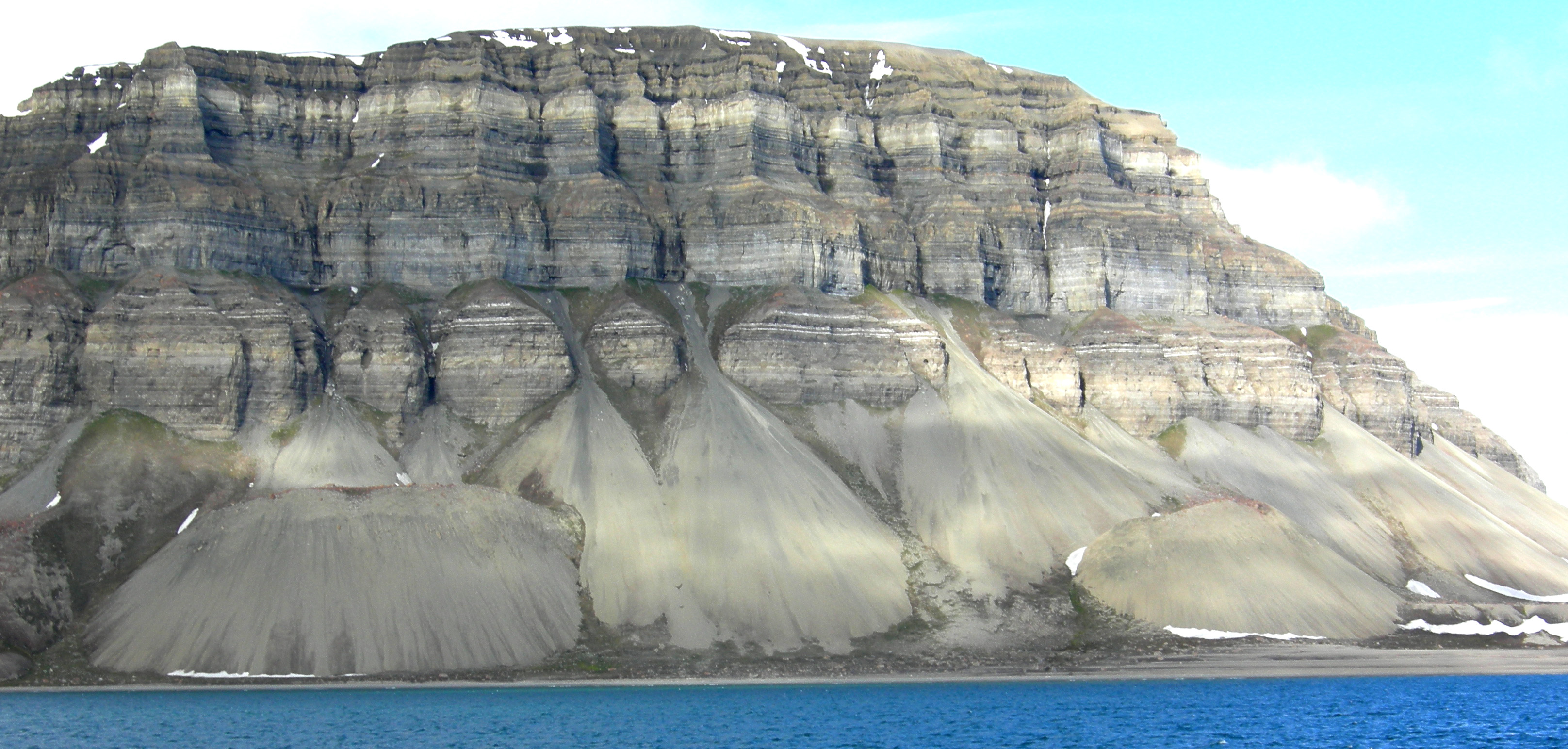
Percy writes: I think Faith believes that geology thinks it happens like this: 1.First there is a landscape of bare rock. I don't call a rock a landscape. I do start from a bare rock in the strata but since that confuses things, make it the sediment from which the rock eventually forms. With the change to sediment from rock the sequence described represents what I've had in mind well enough. Grand Canyon:While the particulars of the formation of any given layer of rock may help visualize the processes involved, I don't regard any particular site such as the Grand Canyon as an example except in the sense that it should provide an image of a deep stack of strata for the sake of visualization. ' But this is another thing I'm realizing I may need to change in this project: I'm considering that I may not need to identify time periods at all because the processes I'm trying to visualize are simply about getting from a landscape to a rock and the time periods assigned to formations may not be necessary to that effort. I'm not entirely sure yet and I may have to come back to the time periods, but for now the idea is to stick to the strata alone and leave out the time periods. It's the time periods that the illustrations of pMessage 333 are intended to represent, rather than layers of rock so I may find that I have to return to the time periods. But for now I'm thinking just in terms of the layers of rock as the former landscapes, and the problem is just getting from landscape to rock without regard to the time periods involved (except, yes, it would help to keep in mind whether I'm talking about a marine environment or a land environment). And in that case any example of strata should do, such as this stratified hill in a picture from the Geomorphology site Moose linked to. It's an illustration of the formation of talus but the strata are quite clear in it:
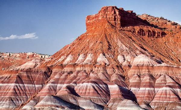
And here's the Chinle formation again, because it too shows a clearly stratified hill and it definitely contains fossils:
Nice straight tight strata in both of those pictures. So to reformulate the problem here: if all strata represent a deposituional environment, the problem now has become explaining how such strata were ever a landscape populated by creatures now represented by their fossils within each layer of rock, and how that landscape became that rock with those fossils in it. The Grand Canyon is a nice neat example because of the variety of rocks and the many time periods represented, but perhaps any strata will do for what I'm trying to figure out. Perhaps. You can tell me why or why not. Edited by Faith, : No reason given. Edited by Faith, : No reason given.
|
|||||||||||||||||||||||||||||||||
|
jar Member (Idle past 414 days) Posts: 34026 From: Texas!! Joined: |
First a few specifics.
In the first picture the emphasis is not on the layers but rather the talus (scree) which are the piles of weathered material seen at the base. There is no information given on what the make-up of the individual layers are so I can only guess at the composition but shale, mudstone, limestone and sand stone seem indicated. But note the actual variations between the different processes that formed each layer. So where would those types of materials form? The Chenile Formation is more interesting since it is a great example of a continental formation. The make-up of the processes there also vary over time and show landscapes ranging from erosive water born deposits to lakes to wetlands and also some wind born deposits like sand dunes. AbE: What is important is that both examples (as well as all the other examples) show a succession of changing landscapes over time with each process forming a layer of material that is indicative and unique to the processes involved. Edited by jar, : see AbE: Edited by jar, : applin spallin so ----> showMy Sister's Website: Rose Hill Studios
|
|||||||||||||||||||||||||||||||||
|
PaulK Member Posts: 17825 Joined: Member Rating: 2.2 |
Well here's the simple outline although we will probably have to consider specific examples to get into the details.
Sediment is deposited. On land it will be subject to weathering, and on land or sea material produced by the life living there - including shells and bodily remains - will be mixed in with it. Eventually conditions will change. On land this may mean a period of erosion which will tend to flatten and even remove layers of past sediment (consider the hoodoos as a particularly dramatic example - their removal by erosion is a flattening of the local landscape). Or it may just mean the deposition of a different sediment. As the sediment builds up, the lower layers will, under the pressure of the material on top of them - be converted to rock.
|
|||||||||||||||||||||||||||||||||
|
Faith Suspended Member (Idle past 1464 days) Posts: 35298 From: Nevada, USA Joined: |
May I ask whether anybody besides me has a problem with the idea of landscapes (whether marine or terrestrial) resolving down to such neat straight tight contacts between strata as shown in those pictures in my post above (Message 711)?
Edited by Faith, : No reason given. Edited by Faith, : No reason given.
|
|||||||||||||||||||||||||||||||||
|
ringo Member (Idle past 432 days)  Posts: 20940 From: frozen wasteland Joined: |
Faith writes:
I don't think anybody is suggesting that every one of those layers represents an entire landscape.
May I ask whether anybody besides me has a problem with the idea of landscapes (whether marine or terrestrial) resolving down to such neat straight tight contacts between strata as shown in those pictures in my post above (Message 711)?
|
|||||||||||||||||||||||||||||||||
|
PaulK Member Posts: 17825 Joined: Member Rating: 2.2 |
Not in the abstract, especially given the limitations of the photographs, and the fact that we know that they are far from the whole story.
If you want to get into a detailed discussion then let's do that. But simply pointing at a couple of photographs is not nearly enough.
|
|||||||||||||||||||||||||||||||||
|
jar Member (Idle past 414 days) Posts: 34026 From: Texas!! Joined: |
Faith writes: May I ask whether anybody besides me has a problem with the idea of landscapes (whether marine or terrestrial) resolving down to such neat straight tight contacts between strata as shown in those pictures in my post above (Message 711)? Great question and the answer is that there are likely other folks than you who have a hard time understanding reality but for most of us there is no problem at all. AbE: The key is that many examples simply are not smooth flat level transitions. The Appalachians is a great example. Right now material is being deposited on slopes, up and down, still far from level but at the same time we know that the high points are being worn and weathered away and that material is being deposited in the valleys and given enough time the final result would be a relatively flat surface. Edited by jar, : see AbE:My Sister's Website: Rose Hill Studios
|
|||||||||||||||||||||||||||||||||
|
14174dm Member (Idle past 1129 days) Posts: 161 From: Cincinnati OH Joined:
|
The transition from one stratum to the next is not always a sharp line. Sometimes the transition is messy.
I did some hunting for "paleosols" which are buried soil layers. When a layer of sediment lies exposed for some time, physical & chemical weathering, biological activity, etc. change the characteristics of the sediment to soil. Some of the characteristics of soils can be found in rock layers after lithification. I found one geology thesis by Joseph John Beer. No particular reason, it just popped up and was a thorough document.
Earth & Environmental Research | Swenson College of Science and Engineering Unfortunately I can't figure out how to post individual pages to this forum. On page 30-31, section 3.1.1 , an example is the author's description of the top of one of the rock layers showing signs of having been a surface soil.
The paleosols formed in the Moenkopi parent material range from 1-7 meters thick....(Figure AI.8). Grain-size of these paleosols is variable, ranging from medium grained sand to dominantly silt and clay. In most cases, especially where the paleosol is finer grained, these rocks weather to form resistant, light-colored ledges (Figures 3.1.1-1, AI.12, AI.41). .... Evidence of soil fabrics include large root traces and burrows; however, often the identification of such features is difficult because the rocks are extensively bioturbated and have undergone multiple stages of oxidation/reduction (Figure AI.8). So this top of this rock layer was, while still sediment, exposed to the air long enough for minerals to leach deeper into the sediment (lighter color), have plants grow (root traces) and animals thrive (burrows). More evidence of soil formation is found in a higher layer as described in pg 33-34 section 3.1.3.
A well-developed gleyed oxisol, similar in nature to the paleosol described in section 3.1.1, marks the base of the Monitor Butte Member immediately above the coarse-grained deposits of the Shinarump Member in White Canyon, at Jacob’s Chair (MS 19), and in Red Canyon (MS 21). At Jacob’s Chair, the paleosol is fine-grained and nearly 6 meters thick. .... Remnant sedimentologic horizonation is crude, however pedogenic indicators such as crayfish burrows and rooted horizons indicate slow overall soil accumulation under highly fluctuating hydrologic conditions. Again, burrows and roots. On page 41, figure 3.1.5-2 shows burrows in the rock to the left of the hammer. A summary of the history of the area is shown on page 65 with the oldest scene A at the bottom of the page. The figures show erosion, deposition, and soil development through time to match the evidence in the rocks. When landscapes are discussed as existing between the rock layers it is because geologists in the field found and documented evidence of time & life - soil development, root traces, and burrows.
|
|||||||||||||||||||||||||||||||||
|
Faith Suspended Member (Idle past 1464 days) Posts: 35298 From: Nevada, USA Joined: |
I don't think anybody is suggesting that every one of those layers represents an entire landscape. I wondered about that myself. But I've been getting the impression 1) that every sediment implies its own depositional environment, 2) and even a very thin layer of sediment could represent a very long time according to the reckonings of the Geological Timescale But it's a question: Perhaps someone will come along and give the official answer from Geology. ABE: And to anyone who is impatient to get the discussion going, I'm still becalmed in the doldrums. But eventually I suppose I can resume. Edited by Faith, : No reason given. Edited by Faith, : No reason given. Edited by Faith, : No reason given.
|
|||||||||||||||||||||||||||||||||
|
jar Member (Idle past 414 days) Posts: 34026 From: Texas!! Joined: |
Faith writes: But it's a question: Perhaps someone will come along and give the official answer from Geology. There is no and hopefully never will be any official answer. Such things are the province of dogma and mythology.
Faith writes: 1) that every sediment implies its own depositional environment, Correct. The process and environment determine the material.
Faith writes: 2) and even a very thin layer of sediment could represent a very long time according to the reckonings of the Geological Timescale It could or it could represent a shorter period like a season or year. Such things will depend on the characteristics of the specific sample.My Sister's Website: Rose Hill Studios
|
|||||||||||||||||||||||||||||||||
|
|
Do Nothing Button
Copyright 2001-2023 by EvC Forum, All Rights Reserved
![]() ™ Version 4.2
™ Version 4.2
Innovative software from Qwixotic © 2024
 (1)
(1)