|

Understanding through Discussion |
|
|
Register | Sign In |
|
QuickSearch
Summations Only | Thread ▼ Details |
|
Thread Info
|
|
|
| Author | Topic: Evolution. We Have The Fossils. We Win. | |||||||||||||||||||||||||||||||||||||||||||
|
jar Member (Idle past 415 days)  Posts: 34026 From: Texas!! Joined: |
Faith writes: Water sorts sediments without mixing them. Layers formed by rivers. Dumping sediment on still wet rock adds mixture and lumpiness. Problem Yet a flood cannot sort layers in the order found in reality and in fact the way water does sort objects is direct evidence that what exists is NOT the result of a flood. Once again, no flood sorts objects like fossils by the specific type of critter involved or sort millions of repeating dark colored silt covered by light colored silt. The Biblical Flood is simply a really silly idea. Edited by jar, : fix sub-title
|
|||||||||||||||||||||||||||||||||||||||||||
|
edge Member (Idle past 1727 days)  Posts: 4696 From: Colorado, USA Joined:
|
In concert with the enormous pressure from above I'm getting more sure that that's what happened.
Of course you become more certain. That is the nature of religious belief.
I started thinking in terms of a volcano because of what I read years ago about there being a volcano there. All the granite in the area is a clue too.
So, you are going to ignore the cross-cutting relationships and age dates, along with the different compositions and stratigraphic relationships, and claim that you read about a volcano, once upon a time. This is what you provide as your evidence. Fine. I think we know where you are coming from. Your statement that your speculation is based on evidence rings hollow.
|
|||||||||||||||||||||||||||||||||||||||||||
|
edge Member (Idle past 1727 days) Posts: 4696 From: Colorado, USA Joined: |
You didn't explain how the boulder broke off from the Shinumo.
I thought it was pretty obvious. The boulder was eroded from the Shinumo hills that rose high above sea level.
How does this "beach" end up in the geological column by the way?
Simple. It is buried. I thought you had a basic understanding of Walther's Law.
You didn't answer whether there is erosion.
Of course there is. That's the whole point.
Woulda coulda shoulda. The whole physical layout of the supergroup in relation to all the other features of the Grand Canyon fits my hypothesis superbly. What implies the strong force from the side is the position of the supergroup up against the Tapeats and the mounding of the strata over it. I could not care less whether some bits of it fit yours.
So, I take it that you are not going to address my evidence. I'm shocked. Edited by edge, : No reason given.
|
|||||||||||||||||||||||||||||||||||||||||||
|
edge Member (Idle past 1727 days) Posts: 4696 From: Colorado, USA Joined:
|
Good grief, what is the necessity of making this ridiculously obvious pronouncement?
The point is made in the next few statements where I point out reasons why the Tapeats is not continuous across the continent.
If you can't see the flatness in the walls of the Grand Canyon you've got a BIG problem
Sure, the layers are tabular. The problem is that you extend this observation to the rest of the planet, when actually it does not go beyond the Colorado Plateau. These 'landscapes' that you envision did not exist at the Grand Canyon. They were flat seafloors for the most part, continually taking sedimentation, even as the depositional environment was changing. Hence, there were no dinosaurs or mammals, just sea life that moved as their environment moved and left fossils when they died. Landscapes do not become rocks. Terrestrial creatures are seldom preserved because they are not buried, but eroded away.
|
|||||||||||||||||||||||||||||||||||||||||||
Faith  Suspended Member (Idle past 1466 days)  Posts: 35298 From: Nevada, USA Joined: |
You didn't explain how the boulder broke off from the Shinumo.
I thought it was pretty obvious. The boulder was eroded from the Shinumo hills that rose high above sea level. Hills indeed. The Shinumo was never anything but a layer in the basement rocks beneath the Grand Canyon, from which a piece thrust into the upper strata when the tectonic upheaval that split the continents moved all those rocks horizontally. How does a boulder of quartzite with a diameter of fifteen feet get "eroded" from anything anyway?
How does this "beach" end up in the geological column by the way?
Simple. It is buried. I thought you had a basic understanding of Walther's Law. This idea that beaches can become rocks in a stack of rocks, or any other landscape for that matter, is just way too bizarre for me. The efforts to show how it could have happened are imaginative but impossible.
You didn't answer whether there is erosion.
Of course there is. That's the whole point. Great. So I'll stop describing the contact between the Supergroup and the Tapeats as "abraded" and say it's eroded. As long as there is evidence of disturbance at the contact it fits my hypothesis well enough.
Woulda coulda shoulda. The whole physical layout of the supergroup in relation to all the other features of the Grand Canyon fits my hypothesis superbly. What implies the strong force from the side is the position of the supergroup up against the Tapeats and the mounding of the strata over it. I could not care less whether some bits of it fit yours.
So, I take it that you are not going to address my evidence. I'm shocked. I guesws so. At some point the futility of having my arguments unfairly trashed over and over does get to me and it's just time to stop. Edited by Faith, : No reason given. Edited by Faith, : No reason given. Edited by Faith, : No reason given.
|
|||||||||||||||||||||||||||||||||||||||||||
|
Faith Suspended Member (Idle past 1466 days) Posts: 35298 From: Nevada, USA Joined: |
The point is made in the next few statements where I point out reasons why the Tapeats is not continuous across the continent. That's utterly irrelevant to the point I was making, which is that these rocks aren't just local.
Sure, the layers are tabular. The problem is that you extend this observation to the rest of the planet, when actually it does not go beyond the Colorado Plateau. All the strata are originally flat wherever they are found. The main difference with those in the GC/GS is that so many of them remained flat for such a depth while strata in other locations are often found tectonically distorted, buckled, bent, twisted. Besides, this is NOT the problem since you've done nothing but deny and deny and deny that there is any flatness or tabularity at all. I can't even make a simple obvious point about flatness without being told I'm wrong even about that. This kind of futility nobody should ever have to endure. It's a form of abuse.
These 'landscapes' that you envision did not exist at the Grand Canyon. Yes, that is correct, I tend to blur the canyon with the Grand Staircase since they are really a unit. The illustrations of landscapes apply to the rocks in the Grand Staircase which is where the dinosaurs are located.
They were flat seafloors for the most part, continually taking sedimentation, even as the depositional environment was changing. Hence, there were no dinosaurs or mammals, just sea life that moved as their environment moved and left fossils when they died.
So what? The task I described can still be done with the Triassic period which is one of those amply illustrated at Google image with loads of foliage and Animalia. It is that sort of landscape that has been addressed too, such as by Modulus. Why don't you address it? Describe how the Triassic landscape became the Triassic rocks.
Landscapes do not become rocks. Terrestrial creatures are seldom preserved because they are not buried, but eroded away. Of course landscapes become rocks. They have to if your idiotic time periods explanation makes any sense at all. Fossils in the rocks are supposedly the remains of what actually lived on that spot, --abe: DON'T YOU DARE DENY THIS AFTER SO MANY HAVE SAID SO FOR THREAD AFTER THREAD /abe -- so show how they got there from their original habitat, or, how the habitat itself got there. The same processes must describe the marine layers too of course. Edited by Faith, : No reason given. Edited by Faith, : No reason given. Edited by Faith, : No reason given. Edited by Faith, : No reason given. Edited by Faith, : No reason given.
|
|||||||||||||||||||||||||||||||||||||||||||
|
Percy Member  Posts: 22480 From: New Hampshire Joined: Member Rating: 4.8
|
And the point is to get from the scenario to the rock. Yes. Were you able to understand the comments on your thinking? I think the key points were:
--Percy
|
|||||||||||||||||||||||||||||||||||||||||||
|
edge Member (Idle past 1727 days) Posts: 4696 From: Colorado, USA Joined:
|
Of course landscapes become rocks.
The way I define a landscape sure. And they do exists. However, the way you define landscape, no, they cannot be preserved as you insist.
They have to if your idiotic time periods explanation makes any sense at all. Fossils in the rocks are supposedly the remains of what actually lived on that spot, -
Or maybe they are not included. You seem to insist the the rock be a snapshot of the actual environment.
-abe: DON'T YOU DARE DENY THIS AFTER SO MANY HAVE SAID SO FOR THREAD AFTER THREAD /abe
I will say as I please. Your notion of 'landscapes' is not what most people think. And the fact is that the Paleozoic formations at the GC had no landscape to preserve. It was a seafloor.
-- so show how they got there from their original habitat, or, how the habitat itself got there.
This question makes no sense. The habitat is whatever the depth of water and source of sediment required.
The same processes must describe the marine layers too of course.
I am discussing the GC formations. There was no 'landscape' to be preserved. You continue to confuse the issue by going back and forth between marine and terrestrial environments. They are different.
So what? The task I described can still be done with the Triassic period which is one of those amply illustrated at Google image with loads of foliage and Animalia. It is that sort of landscape that has been addressed too, such as by Modulus. Why don't you address it? Describe how the Triassic landscape became the Triassic rocks.
The Triassic terrestrial deposits that you mention are lowland deposits. As Percy has mentioned, higher elevations were more subject to erosion and not well preserved. That is why we see rivers and swamps and in the CP area, along with some great ergs.
Besides, this is NOT the problem since you've done nothing but deny and deny and deny that there is any flatness or tabularity at all. I can't even make a simple obvious point about flatness without being told I'm wrong even about that. This kind of futility nobody should ever have to endure. It's a form of abuse.
This is patently wrong. I mentioned the tabular nature of the Grand Canyon section in the very post you are responding to. I said, "Sure, the layers are tabular." My position has always been that the Colorado Plateau and the Grand Canyon do not represent the whole world. In terrestrial rocks, Percy's description holds. You can have deposition but it frequently fills in topography and is not laterally extensive. Even the great Jurassic sandstone formations of the Colorado Plateau do not extend far east into Colorado.
|
|||||||||||||||||||||||||||||||||||||||||||
|
edge Member (Idle past 1727 days) Posts: 4696 From: Colorado, USA Joined:
|
Hills indeed. The Shinumo was never anything but a layer in the basement rocks beneath the Grand Canyon, from which a piece thrust into the upper strata when the tectonic upheaval that split the continents moved all those rocks horizontally.
There is no evidence for thrusting.
How does a boulder of quartzite with a diameter of fifteen feet get "eroded" from anything anyway?
It's called gravity.
This idea that beaches can become rocks in a stack of rocks, or any other landscape for that matter, is just way too bizarre for me. The efforts to show how it could have happened are imaginative but impossible.
Once again, I thought you had a rudimentary understanding of Walther's Law. What happened?
Great. So I'll stop describing the contact between the Supergroup and the Tapeats as "abraded" and say it's eroded. As long as there is evidence of disturbance at the contact it fits my hypothesis well enough.
Now I'm not sure you understand what erosion is. There is no fault, no thrust and no abrasion. It is an erosional unconformity.
I guesws so. At some point the futility of having my arguments unfairly trashed over and over does get to me and it's just time to stop.
If you can't handle the disagreement, then you are probably frustrated due to your lack of experience and knowledge. That is not the fault of anyone but you.
|
|||||||||||||||||||||||||||||||||||||||||||
|
Percy Member Posts: 22480 From: New Hampshire Joined: Member Rating: 4.8
|
Hi Faith,
About your quoting, there was a time when you were getting the indentation reversed, then you learned to get it right, I assume by using the "Peek Mode" radio button that is displayed just above the message you're replying to. Now you're once again getting the quote indentation reversed, which makes it tough to follow your messages, and which makes it more work for you because of the extra typing instead of just placing the [qs] codes around a cut-n-paste. Could you please return to quoting with correct indentation? In this message I'll reverse your reversed quoting so that it is correct. This is a reply to your Message 875 and Message 876 to Edge. Replying to Message 875:
Faith writes: edge writes:
How does a boulder of quartzite with a diameter of fifteen feet get "eroded" from anything anyway? Faith writes:
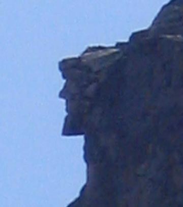
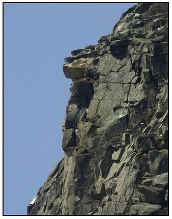
I thought it was pretty obvious. The boulder was eroded from the Shinumo hills that rose high above sea level. You didn't explain how the boulder broke off from the Shinumo. Here in New Hampshire we used to have a famous geological formation in the White Mountains called the Old Man in the Mountain. Here's what it used to look like:
It was so famous it has remained an iconic symbol of New Hampshire for over a hundred and fifty years. It's a mainstay of New Hampshire license plates, and it appears on the reverse of the New Hampshire quarter dollar:
Alas, nothing is forever, and in 2003 cracks that had been appearing for years due to the forces of weathering and erosion finally took their toll, and the Old Man in the Mountain now looks like this:
The missing rock is now at the bottom of Franconia Notch. It's kind of sad, really. When I was young we used to drive by the Old Man in the Mountain every Sunday on our way to the Unitarian Church. But that's what Edge means when in his reply in Message 879 he says that gravity caused the large boulder of quartzite to come to rest on the Tapeats beach below, once the forces of erosion and weathering caused it to break off the Shinumo hills above.
Hills indeed. The Shinumo was never anything but a layer in the basement rocks beneath the Grand Canyon, from which a piece thrust into the upper strata when the tectonic upheaval that split the continents moved all those rocks horizontally. What evidence of thrusting are you looking at? What evidence of the horizontal movement of rocks are you looking at? You appear to be ignoring evidence instead of accepting what it tells you.
edge writes: Faith writes: How does this "beach" end up in the geological column by the way? Simple. It is buried. I thought you had a basic understanding of Walther's Law. I'm surprised that Edge thinks you have a basic understanding of Walther's Law. You still think of Walther's Law as what happens when water rapidly inundates a landform. That's not Walther's Law. The actions of Walther's Law take a great deal of time because they require the geological processes of erosion, weathering, transport, and sedimentation. The results of these processes take a great deal of time to accumulate to the point where they register in the geological record. The layers in the geological record for which Walther's Law played a role were not laid down sequentially. They were laid down simultaneously, just at different distances from shore. At the same time that a sandstone layer is being deposited at or near shore, mudstone layers are being deposited further from shore, limestone layers yet even further from shore, and pelagic layers out in the deep sea far from shore. With the gradually changing elevation of the land the shoreline will move gradually either inland or out to sea, and the type of deposit at a given location (sand, mudstone, limestone, pelagic) will change depending upon the new distance from shore. That land slopes down to the sea and then continues sloping down once beneath the sea guarantees that sedimentary layers following Walther's Law cannot be precisely horizontal. They will follow the slope of the land.
Faith writes: This idea that beaches can become rocks in a stack of rocks, or any other landscape for that matter, is just way too bizarre for me. The efforts to show how it could have happened are imaginative but impossible. The processes of Walther's Law cannot be impossible since that is what is observed to be happening today at shorelines all around the world.
Faith writes: edge writes: Faith writes: You didn't answer whether there is erosion. Of course there is. That's the whole point. Great. So I'll stop describing the contact between the Supergroup and the Tapeats as "abraded" and say it's eroded. As long as there is evidence of disturbance at the contact it fits my hypothesis well enough. What you're calling a "disturbance" at the interface between the Grand Canyon Supergroup and the Tapeats is actually, in proper terminology, an unconformity, and if you now agree that the unconformity was caused by erosion, which requires it being at the surface, then you have to give up on your earlier idea that the Supergroup tilted while buried, something that is not supported by any evidence.
Faith writes: edge writes: Faith writes: Woulda coulda shoulda. The whole physical layout of the supergroup in relation to all the other features of the Grand Canyon fits my hypothesis superbly. What implies the strong force from the side is the position of the supergroup up against the Tapeats and the mounding of the strata over it. I could not care less whether some bits of it fit yours. So, I take it that you are not going to address my evidence. I'm shocked. I guess so. At some point the futility of having my arguments unfairly trashed over and over does get to me and it's just time to stop. I guess that presenting evidence that shows your arguments untenable could be characterized as trashing them, but there is nothing unfair about it. Evidence is the currency of debate here. If your arguments do not stand up in the face of evidence then you lose the debate. Edge is pointing out that a "strong force from the side" would create folds and fractures in the Supergroup's rocks, and that the absence of these folds and fractures means there could have been no "strong force from the side". He also said that there is "no fault, no thrust and no abrasion. It is an erosional unconformity." A "strong force from the side" could not tilt the Supergroup strata while buried. Tectonic forces that tilt strata would have affected the overlying layers (the Tapeats and above) in the same way as the Supergroup. As has been pointed out many times before, tilting buried layers isn't possible as it requires many cubic miles of strata to simply disappear. Replying to your Message 876:
Faith in Message 876 writes: The point is made in the next few statements where I point out reasons why the Tapeats is not continuous across the continent. That's utterly irrelevant to the point I was making, which is that these rocks aren't just local. If you go back to your original point in Message 840, the word "local" never even appears, nor in any of your other messages in this recent dialog with Edge:
Faith in Message 840 writes: The strata in some cases cover thousands of square miles of unbroken flatness, between others of similar flatness. The Tapeats covers most of North America, so does the Redwall Limestone. Really, this is not how the surface of the earth is built up. It doesn't happen. This whole scenario is absurd. I don't know how you or any geologist got yourself persuaded of such nonsense. You don't say "local", but you do refer to the Tapeats and the Redwall Limestone as covering "most of North America." As Edge points out, the Tapeats is not continuous across the continent. You can't just look at the Tapeats in the Grand Canyon region and declare that it has the same qualities everywhere else that it does there. It thickens and thins and in some places pinches out completely. You wouldn't call a table top that thickens and thins and has holes and varying elevations above the floor as flat across its entire extent - why would you describe the Tapeats that way? Both the Tapeats and the Redwall Limestone exist only in the western US, specifically in Arizona, California, New Mexico and Utah.
Sure, the layers are tabular. The problem is that you extend this observation to the rest of the planet, when actually it does not go beyond the Colorado Plateau. All the strata are originally flat wherever they are found. The main difference with those in the GC/GS is that so many of them remained flat for such a depth while strata in other locations are often found tectonically distorted, buckled, bent, twisted. In many locations the strata are flat for great extents, and in many locations they're not. The structure of strata vary according to what tectonic forces the region has experienced.
Besides, this is NOT the problem since you've done nothing but deny and deny and deny that there is any flatness or tabularity at all. How can you describe Edge as having denied and denied and denied that there is "any flatness or tabularity at all" when you just quoted him saying, "Sure, the layers are tabular."
I can't even make a simple obvious point about flatness without being told I'm wrong even about that. What Edge actually said was that the layers are flat in the Colorado Plateau region, but that that isn't true in other regions. You basically just said the same thing: "The main difference with those in the GC/GS is that so many of them remained flat for such a depth while strata in other locations are often found tectonically distorted, buckled, bent, twisted."
This kind of futility nobody should ever have to endure. It's a form of abuse. You're creating your own futility and abuse.
They were flat seafloors for the most part, continually taking sedimentation, even as the depositional environment was changing. Hence, there were no dinosaurs or mammals, just sea life that moved as their environment moved and left fossils when they died.
So what? The task I described can still be done with the Triassic period which is one of those amply illustrated at Google image with loads of foliage and Animalia. It is that sort of landscape that has been addressed too, such as by Modulus. Why don't you address it? Describe how the Triassic landscape became the Triassic rocks. If Modulous has already described it, why do you need Edge to describe it again?
Landscapes do not become rocks. Terrestrial creatures are seldom preserved because they are not buried, but eroded away. Of course landscapes become rocks. They have to if your idiotic time periods explanation makes any sense at all. As he indicates in his reply in Message 878, Edge is differentiating between the actual definition of a landscape and your own definition of landscape. I'm not actually clear on how either of your are defining "landscape," some clarification would be helpful.
Fossils in the rocks are supposedly the remains of what actually lived on that spot,... As Edge points out, strata are not snapshots of what lived in that location. The odds of any life dying in circumstances that encourage preservation is small. Fossil vegetation is extremely rare. Fossils of small creatures are less rare but still very rare. Fossils of larger creatures are rare. The fossils found in any strata are only a partial picture of what lived there.
--abe: DON'T YOU DARE DENY THIS AFTER SO MANY HAVE SAID SO FOR THREAD AFTER THREAD /abe -- Of course a strata will predominantly have fossils of life that inhabited the region, but it is possible for life outside the region to be carried downstream and become buried in a lowland area or even in coastal waters.
...so show how they got there from their original habitat, or, how the habitat itself got there. Like Edge, I'm unable to make sense of this question. Are you asking what forces are responsible for creating the various types of habitats that can exist? If so, how is that relevant to the discussion?
The same processes must describe the marine layers too of course. I think the processes responsible for creating habitats would differ between land and sea. For example, there are no rivers in the sea. Erosion is not much of a factor beneath the waves. Water doesn't flow down submerged mountains. There's no rain. And again, how is this relevant to the discussion? --Percy Edited by Percy, : Spelling.
|
|||||||||||||||||||||||||||||||||||||||||||
|
Faith Suspended Member (Idle past 1466 days) Posts: 35298 From: Nevada, USA Joined: |
I can't keep the quote order in mind for some reason.
Your example of the eroded "face" is about a kind of rock that is more easily eroded than quartzite:Wikipedia says: Quartzite is very resistant to chemical weathering and often forms ridges and resistant hilltops But I find the whole landscape idea absurd anyway. The Shinumo is a layer of quartzite among other layers, it's not a hill in a landscape, just as the Tapeats is a layer of sand in a depth of strata and not a beach.
Hills indeed. The Shinumo was never anything but a layer in the basement rocks beneath the Grand Canyon, from which a piece thrust into the upper strata when the tectonic upheaval that split the continents moved all those rocks horizontally. What evidence of thrusting are you looking at? What evidence of the horizontal movement of rocks are you looking at? You appear to be ignoring evidence instead of accepting what it tells you I have an overview of the whole geological situation in the canyon area based on that cross section that has been referred to so many times in the past, and the overview is what dictates the horizontal movement and the thrusting. The schist and the granite are also pretty much confined beneath the Paleozoid strata. There are photos of the Tapeats as a hard shelf of rock showing both its flat horizontality and its position on top of those rocks. The quartzite is the only rock that penetrated into the Paleozoic strata. The strata were pushed up by the Supergroup, it did not penetrate the Tapeats as the quartzite did. This is just one piece of evidence that all the basement rocks were confined beneath the strata when the Supergroup was tilted. Tilted and obviously pushed upward into the Tapeats. The quartzite was the only rock capable of benetrating the Great Unconformity because it is harder than the others. The mounding or rise over the Supergroup is evidence that the strata were already in place when the tilting occurred because strata would not deposit neatly on such a mound. I know you disagree but you are wrong to disagree. All the strata are originally laid down flat and horizontal everywhere, and except for that hill or rise over the Supergroup that is what is seen in the canyon area too: straight flat strata in the cross section and in most of the photos of the walls of the Grand Canyon. The main evidence of horizontal movement is the boulder which is a quarter mile from its origin.But the tilting of the Supergroup is also evidence of that, as it is in any angular unconformity. Yes Geology interprets all of this differently, I disagree and have a different interpretation. Once I've got the whole scenario in mind Edge's little pieces of evidence, such as whether a surface is "abraded" or not are simply irrelevant. I also interpret Walther's Law to apply with a rapid rise of water and not just a slow rise. Why not? The slow rise is just an element of the standard Geo interpretation which I disagree with. But also the idea that Walther's Law defines the Tapeats as a former "beach" is ludicrous. Are all the basement rocks we see in the GC underneath that beach? Did the sea retreat that far that we now have a canyon in a desert where the beach used to be? I suppose this will be insisted upon but I can't buy it. Walther's Law applies to the ordering of the strata but the Tapeats was a "beach" for a very short period in the rapid rising of the sea and the rapid deposition of the layers.
What you're calling a "disturbance" at the interface between the Grand Canyon Supergroup and the Tapeats is actually, in proper terminology, an unconformity, and if you now agree that the unconformity was caused by erosion, which requires it being at the surface, then you have to give up on your earlier idea that the Supergroup tilted while buried, something that is not supported by any evidence. Well, we have a definitional problem here. Erosion is simply disturbed rock, rubble, and it does not have to have occurred at the surface, it can also occur between strata and I would assume when one rock moves in contact with another. There is enough evidence of the tilting of the Supergroup while buried in the mounding of the strata over it. As long as I have a clear idea of how all this worked together, and the evidence for it I've already mentioned, Edge's preoccupation with the lack of things like faulting is simply irrelevant. The overall scenario works, so the small scale evidence has to give. He's always going to be thinking in his own paradigm and I'm always going to be thinking in mine where his observations are irrelevant. I'll try to get back to this later. Edited by Faith, : No reason given. Edited by Faith, : No reason given. Edited by Faith, : No reason given. Edited by Faith, : No reason given. Edited by Faith, : No reason given.
|
|||||||||||||||||||||||||||||||||||||||||||
|
PaulK Member Posts: 17825 Joined: Member Rating: 2.2
|
quote: Nobody is calling the Shinumo quartzite a hill in a landscape. It would be fairer to call it the bones of an ancient landscape including a number of hills. (I.e. it was rock at the time the landscape existed). Or islands, rather than hills, as they were when the Tapeats was being deposited. And the Tapeats certainly seems to have been deposited at a shoreline, down to the marks left by ripples.
quote: That isn’t evidence for your ideas. It only tells us that the absence of the evidence is a problem for your ideas. Which we already knew.
quote: That’s your assumption, not evidence.
quote: Which is better explained by the conventional view, as having been eroded from the Shinumo when it was already lithified and buried in the sediment that became the Tapeats
quote: And the evidence favours the interpretation of conventional geology. Your interpretation doesn’t even make sense.
quote: In other words you have your fantasy and the evidence against it doesn’t matter. If the angular unconformity formed in the way you say there should be abrasion - you claim that there was abrasion. The lack of any evidence of abrasion is quite damning.
quote: That’s because you are so determined to find evidence of the Flood you fail to understand what you are talking about. The particular sequences you are talking about are produced by the different environmental zones along a coastline. The rise or fall of the water is only relevant in that the zones move with it. But the Flood is supposedly dominated by huge amounts of suspended sediment. Natural production would be irrelevant. Really - we can’t know what the Flood would do but you somehow know that it would naturally mimic the sequences produced by slow changes in sea level? Why?
quote: That is a really odd argument. The only thing you reject is the timescale and yet the environmental changes obviously make more sense in the long timescale proposed by science. If even you imagine that the region was submerged you can hardly have a sensible objection.
quote: Well, yes you have a problem. Rock rubbing against rock would be abrasion for which there is no evidence.
quote: There is obvious evidence against it. The fact that the major fault in the supergroup obviously occurred before the upper strata were deposited, for one. This is the usual Grand Staircase diagram and it really is obvious.
quote: It doesn’t work, you don’t have any significant evidence for it, and the evidence against it is quite sufficient to refute it.
quote: No, the basic problem is that your thinking is apologetic (and in a bad way) and anti-scientific. You are trying to force fit everything into your scenario so naturally you dismiss contrary evidence as irrelevant - evidence only counts if you think it supports your scenario (and even there your bias causes you to make obvious mistakes). Geology, as a branch of science places the evidence first. And placing the evidence first proves you utterly wrong. That’s why you have to ignore or misrepresent so much of it. Edited by Adminnemooseus, : Fix a quote box.
|
|||||||||||||||||||||||||||||||||||||||||||
|
Taq Member  Posts: 10038 Joined: Member Rating: 5.3 |
Faith writes: Besides, this is NOT the problem since you've done nothing but deny and deny and deny that there is any flatness or tabularity at all. I can't even make a simple obvious point about flatness without being told I'm wrong even about that. It is your flat denial that water deposition creates flat deposits that is most troubling. You are amazed that water can produce deposits that span thousands of square miles, yet features like the Mediterranean Sea cover nearly 1 million square miles. 70% of the Earth is currently under water. Where is the problem?
|
|||||||||||||||||||||||||||||||||||||||||||
|
NoNukes Inactive Member
|
Faith writes: but this steady diet of debunker while refusing even to see how clever my scenario is If my signature file was not already full... Under a government which imprisons any unjustly, the true place for a just man is also in prison. Thoreau: Civil Disobedience (1846) "Give me your tired, your poor, your huddled masses yearning to breathe free, the wretched refuse of your teeming shore. Send these, the homeless, tempest-tossed to me, I lift my lamp beside the golden door! We got a thousand points of light for the homeless man. We've got a kinder, gentler, machine gun hand. Neil Young, Rockin' in the Free World. Worrying about the "browning of America" is not racism. -- Faith I hate you all, you hate me -- Faith
|
|||||||||||||||||||||||||||||||||||||||||||
|
Percy Member Posts: 22480 From: New Hampshire Joined: Member Rating: 4.8
|
Faith writes: I can't keep the quote order in mind for some reason. Not quote order. Quote indentation. If you cut-n-paste the quoted text using Peek Mode it all just works itself out automatically.
Your example of the eroded "face" is about a kind of rock that is more easily eroded than quartzite: Wikipedia says: Quartzite is very resistant to chemical weathering and often forms ridges and resistant hilltops The Shinumo includes both quartzite and sandstone, and everything erodes eventually. Here's our old friend:
Just for reference, here's a link to the high resolution version:xxxxxx  ub_list_no_initialsort%2Cpub_date%2Cpub_list_no%2Cseries_no;lc:RUMSEY~8~1&mi=0&trs=2]-->Geologic Cross Section of the Cedar Breaks - Zion - Grand Canyon Region ub_list_no_initialsort%2Cpub_date%2Cpub_list_no%2Cseries_no;lc:RUMSEY~8~1&mi=0&trs=2]-->Geologic Cross Section of the Cedar Breaks - Zion - Grand Canyon Region It's hard to read "Shinumo" in the low-res version, but what looks like a little lump sticking up into the Tapeats and Bright Angle Shale beneath the Grand Canyon is the Shinomu Quartzite layer. At one time this was ocean front with cliffs of sandstone and quartzite. Quartzite boulders would occasionally break off the cliffs and tumble down to the beach below or perhaps crash into the shallow waters offshore.
But I find the whole landscape idea absurd anyway. The Shinumo is a layer of quartzite among other layers, it's not a hill in a landscape, just as the Tapeats is a layer of sand in a depth of strata and not a beach. This is incorrect. That lump of Shinumo Quartzite was once a long stretch of island in a great sea. The island's coastline would have consisted of cliffs and beaches.
Hills indeed. The Shinumo was never anything but a layer in the basement rocks beneath the Grand Canyon, from which a piece thrust into the upper strata when the tectonic upheaval that split the continents moved all those rocks horizontally. What evidence of thrusting are you looking at? What evidence of the horizontal movement of rocks are you looking at? You appear to be ignoring evidence instead of accepting what it tells you I have an overview of the whole geological situation in the canyon area based on that cross section that has been referred to so many times in the past, and the overview is what dictates the horizontal movement and the thrusting. What do you mean by overview? Do you mean your own summary description, and is that what follows? If so, then how can you have an overview that "dictates the horizontal movement and the thrusting"? Only evidence can dictate what happened.
The schist and the granite are also pretty much confined beneath the Paleozoic strata. There are photos of the Tapeats as a hard shelf of rock showing both its flat horizontality and its position on top of those rocks. As Edge has pointed out, and I reexplained in my previous message, the Tapeats is only roughly flat and certainly not horizontal. It gets thicker and thinner and in some places is completely pinched out.
The quartzite is the only rock that penetrated into the Paleozoic strata. The Shinumo Quartzite did not penetrate up into the Paleozoic strata. Rather, after the Supergroup became exposed at the surface and was exposed to the forces of erosion the Shinumo, because it was harder, it eroded more slowly than the other Supergroup layers. That's what happens to harder rock or at least rock that is capped by harder rock - it sticks up from the surrounding landscape, like Monument Valley:
These buttes are sticking up from the valley floor because they eroded more slowly than the surrounding landscape, not because they were thrust up from below.
The strata were pushed up by the Supergroup, it did not penetrate the Tapeats as the quartzite did. I think what you're saying is that the Paleozoic strata were pushed up by the Supergroup, and that only the Shinomu Quartzite layer penetrated the Tapeats. This has at least a couple problems. First, much of the elevated region is underlain by granite, not the Supergroup, so it must have been the entire region that included both the granite and the Supergroup that was pushed upward. It wasn't just the Supergroup that was pushed upward. There is no known way for just the Supergroup but not the granite to exert an upward force anyway. And second, your view that the Supergroup strata were at one time parallel to the Paleozoic strata and then were later tilted is problematic, as mentioned earlier. It requires cubic miles of rock to simply disappear. Just look at the above image of the Grand Staircase and extend the lines between the supergroup layers to the right into the Paleozoic layers. That represents the original extent of the Supergroup layers. If all that rock was originally present beneath the Paleozoic layers, then where did it go when the Supergroup layers tilted? Since it is nowhere to be found, and since cubic miles of rock can't simply evaporate into thin air, this cannot be what happened. And third, any upward force on the Supergroup, even in the form of an uneven force (meaning more on the right side then the left in the diagram, i.e., a tilting force), would be transmitted to the Paleozoic layers also. Just as the granite pushing upwards would have transmitted that force to the Bass formation at the bottom of the Supergroup, the Bass formation would have transmitted the force to Hakatai, which in turn would have transmitted it to the Shinumo, and in turn to the Dox, and in turn to the Tapeats, and in turn to the Bright Angel Shale, and so forth right up to the Kaibab at the top. This is what we see in the uplift of the Grand Staircase region. All the strata from the basement granite to topmost layers were uplifted. It isn't possible for only deeply buried strata to be uplifted - uplift of deeply buried strata couldn't fail but to uplift the layers above them.
This is just one piece of evidence that all the basement rocks were confined beneath the strata when the Supergroup was tilted. Tilted and obviously pushed upward into the Tapeats. It isn't a "piece of evidence" or even evidence at all, just faulty thinking.
The mounding or rise over the Supergroup is evidence that the strata were already in place when the tilting occurred because strata would not deposit neatly on such a mound. The Supergroup was tilted long before the overlying layers were deposited, and it was uplifted right along with all the other layers in the Grand Canyon region.
I know you disagree but you are wrong to disagree. You can say that when you have a scenario that doesn't violate a basic law of nature, the law of conservation of matter.
All the strata are originally laid down flat and horizontal everywhere,... Sedimentation tends to fill in the lowest areas first and hence tends to level out a landscape, but unless the slope is too great it will also tend to conform to a landscape. The strata are only mostly flat and approximately horizontal. The more closely the strata are examined the less flat they appear, and varying strata thickness makes horizontality impossible.
The main evidence of horizontal movement is the boulder which is a quarter mile from its origin. A quarter mile is a very, very short distance geologically. The sea could easily have eroded the Shinumo back a quarter mile from the time when the boulder fell into the Tapeats.
But the tilting of the Supergroup is also evidence of that, as it is in any angular unconformity. The tilting of the Supergroup tells us that long before there were any Paleozoic layers there was uplift in the region (perhaps even a mountain building event) that tilted the layers. The tilted uplifted region was gradually eroded away until only what we see now was left. The region subsided gradually taking it beneath the waves and resulting in the deposit of marine layers on top of it, beginning with the Tapeats, Bright Angel Shale and Muav Limestone, which were likely deposited simultaneously though not in the same location. While the Tapeats was being deposited relatively close to shore, the Bright Angel Shale was being deposited further away from shore, and the Muav Limestone was being deposited in shallow waters far from shore. As the coastline moved inland the locations where these layers were being deposited moved with it.
Yes Geology interprets all of this differently, I disagree and have a different interpretation. What is happening geologically isn't open to interpretation. What we see happened in the strata we can see happening today. You may be unable to admit this to yourself, but that doesn't lend any validity to your "interpretation."
Once I've got the whole scenario in mind Edge's little pieces of evidence, such as whether a surface is "abraded" or not are simply irrelevant. Denigrating the clear evidence of geology doesn't make it disappear.
I also interpret Walther's Law to apply with a rapid rise of water and not just a slow rise. Why not? Why can't Walther's Law apply to a rapid rise of water? Because Walther's Law requires the slow geologic processes of erosion, weathering and transport to bring the sedimentary products to the sea (the lowest point) where they are differentiated by particle size into sand, mud, and pelagic sediments and sink to the bottom according to particle size/density and water energy.
The slow rise is just an element of the standard Geo interpretation which I disagree with. Inundating a landscape with flood water does not produce differentiated sedimentary deposits. Floods everywhere just leave mud behind. The 2011 Japan tsumami left only a thin layer of mud behind.
But also the idea that Walther's Law defines the Tapeats as a former "beach" is ludicrous. The Tapeats strata represents a former coastal area. As subsidence brought the coastline further and further inland, the area on the immediate coast that was beach moved with it. If the Shinomu Quarzite boulder found in the Tapeats first came to rest on a beach it would have eventually found itself submerged and buried in sand as the land continued subsiding and the coastline continued moving inland.
Are all the basement rocks we see in the GC underneath that beach? Again, the Tapeats represents coastal deposits.
Did the sea retreat that far that we now have a canyon in a desert where the beach used to be? Most of the layers in this region are marine. The region rose above and sank beneath the waves at least a couple of times while the Paleozoic layers were being deposited.
Walther's Law applies to the ordering of the strata... No, Walther's Law describes a geologic process that occurs over long periods of time as land sediments are transported to sea coasts as coastlines move both inland (subsidence or rising sea levels) and out to sea (uplift or lowering sea levels).
...but the Tapeats was a "beach" for a very short period in the rapid rising of the sea and the rapid deposition of the layers. Floods do not strip landscapes down to bedrock and then deposit sorted sediments with sorted fossils and sorted radiometric ages.
What you're calling a "disturbance" at the interface between the Grand Canyon Supergroup and the Tapeats is actually, in proper terminology, an unconformity, and if you now agree that the unconformity was caused by erosion, which requires it being at the surface, then you have to give up on your earlier idea that the Supergroup tilted while buried, something that is not supported by any evidence. Well, we have a definitional problem here. Erosion is simply disturbed rock, rubble,... This would be incorrect. Erosion is the gradual wearing away of soil and rock by the forces of rain, wind and flowing water.
...and it does not have to have occurred at the surface,... Erosion can only occur where there is rain, wind or flowing water, which occurs almost exclusively on the surface, the only exceptions being some caves.
...it can also occur between strata... Erosion cannot occur between strata. That would require flowing water. Underground water exists in aquifers. An aquifer is permeable rock through which water can (slowly) flow. Water in an aquifer cannot erode the rock nor carry sediment.
...and I would assume when one rock moves in contact with another. The rock beneath the ground is not moving around except under special circumstances like earthquakes.
There is enough evidence of the tilting of the Supergroup while buried in the mounding of the strata over it. As described above and in numerous other messages, the tilting of buried layers without affecting overlying layers and with no place for the missing cubic miles of rock to go is impossible.
The overall scenario works,... If in reality your scenario worked then you would have answers for the objections.
He's always going to be thinking in his own paradigm and I'm always going to be thinking in mine where his observations are irrelevant. Edge's observations involve evidence, while your "paradigm" is contradicted by the evidence. --Percy
|
|||||||||||||||||||||||||||||||||||||||||||
|
|
Do Nothing Button
Copyright 2001-2023 by EvC Forum, All Rights Reserved
![]() ™ Version 4.2
™ Version 4.2
Innovative software from Qwixotic © 2024