|

Understanding through Discussion |
|
|
Register | Sign In |
|
QuickSearch
| EvC Forum active members: 63 (9162 total) |
|
| |
| popoi | |
| Total: 916,385 Year: 3,642/9,624 Month: 513/974 Week: 126/276 Day: 23/31 Hour: 0/0 |
Summations Only | Thread ▼ Details |
|
Thread Info
|
|
|
| Author | Topic: Evolution. We Have The Fossils. We Win. | |||||||||||||||||||||||||||||||||||||||||||
|
Percy Member  Posts: 22479 From: New Hampshire Joined: Member Rating: 4.7
|
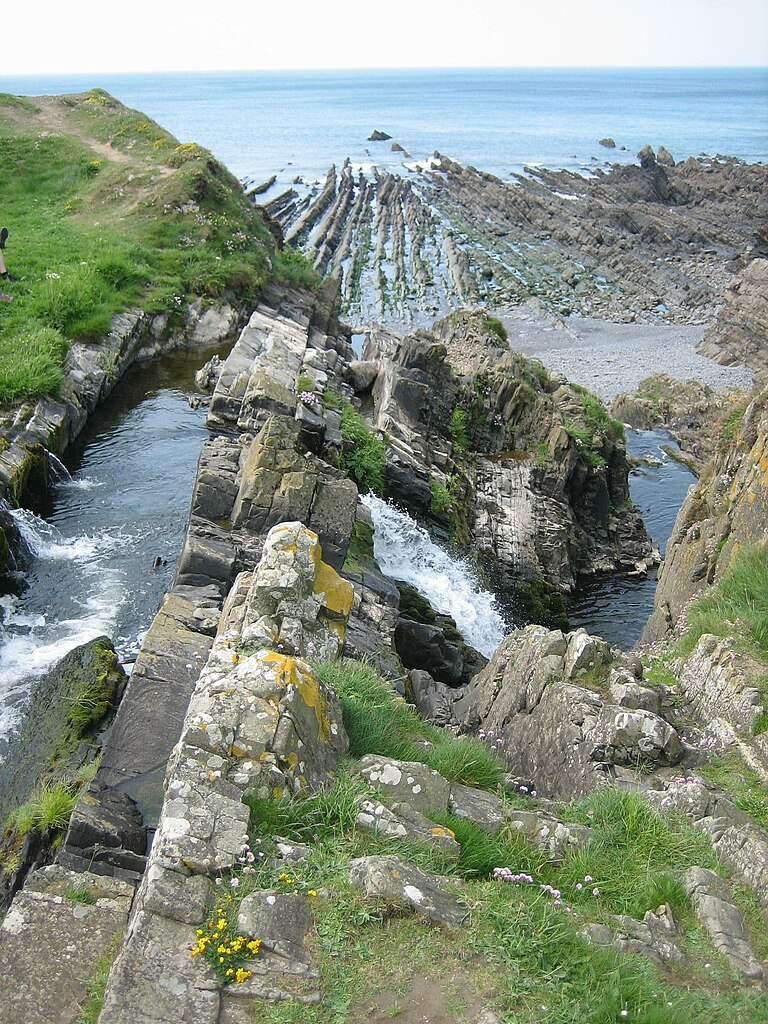
Faith writes: I don't know what the picture is supposed to demonstrate,... You mean this picture?
This is Welcombe Mouth Beach in North Devon, England. Here's a better image that puts things more in perspective:
What look like plowed up rows of sand are actually the eroded edges of tilted strata. That's why Edge said that if this bench were to become buried beneath sediments that it would form an angular uncomformity. Maybe this one is even better, because in the foreground it shows more clearly that what look like plowed up furrows are rocks that are prominent on the left and then become smaller and smaller as you look toward the right. This image blows up pretty big and the details should be easy to see:
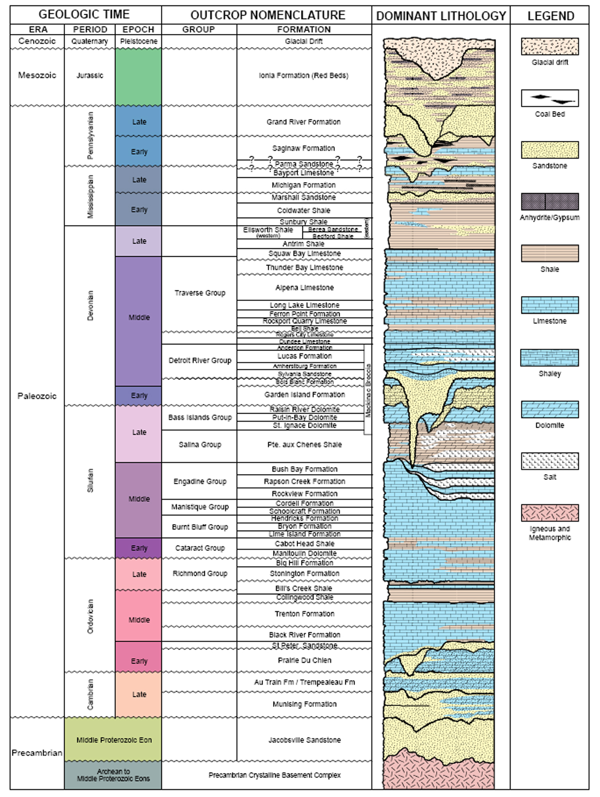
...don't get the point about "numerous valleys and hills within the Lower Peninsula sedimentary rocks as the diagram shows,"... Here's the diagram again. I'm posting my version rather than Edge's because although his has more detail you said you couldn't see it. I don't think the two images are of the exact same stratigraphic column, but I don't think they're too far apart either. An example of hills and valleys can be seen not too far from the top of the diagram where the Parma Sandstone overlays the Bayport Limestone.
What does it have to do with the geologic column? It's a stratigraphic column of the Lower Peninsula that fits into the framework of the geologic column. The original point Edge was making in his Message 2370 was that strata contacts can be (in your words) "lumpy and irregular and composed of all kinds of mixed sediments". --Percy
|
|||||||||||||||||||||||||||||||||||||||||||
|
Percy Member Posts: 22479 From: New Hampshire Joined: Member Rating: 4.7 |
Faith writes: If it can be proved from physical evidence then it isn't religion, it doesn't matter that it started from the Bible. Proving it from the physical evidence is what I'm trying to do, and of course I think I'm doing a pretty good job. If a candidate for office campaigned hard but got zero votes, which is what you've accomplished here, do you think she'd be justified in concluding she had done a pretty good job?
Please do not address posts to me that you mean for somebody else, just as a way to insult me. Very little would be said about you if you didn't keep making absurd claims about yourself, such as how brilliant you are and what a great job you're doing, and if you didn't keep casting insults at the concepts and evidence presented to you, such as that they're mere illusions or paradigm dependent interpretations or mental cobwebs. Focus on facts and arguments.
I don't know if you succeeded in demonstrating anything about flat planar features to anybody else, but you did manage to mystify and insult me so I guess you can congratulate yourself. If you don't understand something then ask questions and discuss details. It is because you instead express incredulity and are hostile to information and explanations that Edge said he didn't think you'd understand, and that he thought what your doing is religion, not science. --Percy
|
|||||||||||||||||||||||||||||||||||||||||||
|
Percy Member Posts: 22479 From: New Hampshire Joined: Member Rating: 4.7 |
Faith writes: You talk about "fossils" but also about things growing where they were found, which of course fossils can't do. I think Moose may have misspoke a bit in his second paragraph. He wasn't supporting your flood scenario but introducing a point against it. When he said "life (as fossils) were growing where they were found" what I think he meant to say was that life became entombed and eventually became fossils in the same environment where they lived. I think he used the crinoid fossil as an example because it fit his point so well, an animal that lives in a single place its entire life attached by a stalk to a rock. Here's his image:
And here's a page of information about it: HUGE CRINOID FOSSIL - SEIROCRINUS SUBANGULARIS. It was found in shale (just what you'd expect for an animal living in offshore waters) from the Jurassic period. When it died it was buried in silt and mud, eventually buried deeply enough to lithify the silt and mud and fossilize the crinoid. The slab also contains a few belemnites - they're the thin wedge-like shapes. One lies directly across the crinoid stalk near the person's left hand.
Maybe I'd see how some creatures could be deposited live and grow in place if I could picture better what you are talking about. Moose doesn't describe it, but the crinoid (and the belemnites) lived in an offshore environment within a few miles of the coast. Runoff from land or sediment from streams and rivers flowed into the sea. The heaviest sediment, mostly sand, fell out of suspension at or very near the coast, where beaches form. The lighter sediment such as silt and mud could not fall out of suspension in the energetic water of the coast (the waves), so it was carried further out to sea where, in quieter waters, it slowly fell out of suspension to the sea floor. A common rate of deposition would have been on the order of inches per thousand years. In this environment sea creatures' life was unimpeded by the very, very light fall of sediments, far, far too slow to actually bury anything and preserve it before sea scavengers consumed it, but burials of recently dead life would still happen. I think one common way would be during heavy rains or storms or during spring melt when huge sediment loads could be suddenly swept into the oceans from runoff from land and from rivers and streams, or sediments could be swept up by stormy seas from sea bottoms. Moose and/or Edge might want to comment on how they see burials occurring. --Percy
|
|||||||||||||||||||||||||||||||||||||||||||
|
Percy Member Posts: 22479 From: New Hampshire Joined: Member Rating: 4.7 |
Faith writes: I guess there's no point in repeating how I see it, is there? Well, that depends. Are you going to repeat something that in the past you've ignored rebuttals?
The historical sciences are all unprovable mental conjuring. Apparently you are going to repeat an old rebutted claim. So to repeat just one of the many forms of rebuttal, and yet you like forensics, which is the study of evidence left behind in the past. Perhaps you heard about the recent arrest of the Golden State Killer based upon DNA evidence from over 30 years ago. There is no statute of limitations on the age of evidence. Ancient evidence is how we know about ancient civilizations, for instance this Canaanite tomb:
Their claims can't be tested or replicated. So they've got a whole complex edifice built only out of imagination, and if you really carefully examine it you can see it doesn't hold together. Eventually it will collapse but I guess it's going to take a while. So if you believe claims about the ancient Canaanites can't be tested or replicated, why? And if you believe they can, then how old does evidence have to be before you believe it cannot be tested or replicated, and why? --Percy
|
|||||||||||||||||||||||||||||||||||||||||||
|
Percy Member Posts: 22479 From: New Hampshire Joined: Member Rating: 4.7 |
Faith writes: Well, thanks for trying but I still can't see how you'd get a flat horizontal rock like those in the geo/strat column from that landscape. Edge didn't reply, so I'll provide an answer. This is the image Edge provided:
As explained earlier, this is Welcombe Mouth Beach in North Devon, England. What appear to be furrows of sand are actually the rocky edges of strata tilted at some steep angle, approximately 45° judging by other images I found that I won't bother to present here. Here's the image that provides a more broad view of the beach:
If you blow this image up you can see that it is quite detailed. In the foreground you can see the rocks extending out into the water, and it is much easier to tell that they are rock and not sand. You can also see that the beach extends on down into and beneath the water representing what in geology is called a bench. The active water along the beach (in the form of waves and storms) is gradually eroding the cliff walls, and the products of erosion fall onto the beach where they are worked by the water into smaller and smaller rocks, pebbles, sand and tiny particles. Sediment is also delivered to the beach through runoff from the land. Only heavy sediments like sand, rock, pebbles, etc., will settle out in this active water near the shore. Any finer and lighter particles washed into the ocean from the land or created by the active water grinding rock and sand into finer and lighter particles will not be able to settle out near the beach and will be carried out to sea into quieter waters where they will gradually fall out of suspension. Take a careful look at the cliff face that lines the beach. Even if sea levels remain the same the cliff face will gradually erode away inland. Gentle wave action has a small effect over time just grinding away at the sand and grinding sand against the rock, while huge waves created by storms can crack rocks clean away from the cliff face. As the cliff face erodes inland the beach moves inland with it, leaving behind it a layer of sand deposited atop the edges of the tilted strata that can be so clearly seen sticking out of the sand in the first image of this message. The sediments atop the tilted strata would constitute an angular unconformity. Edge said that that angular unconformity might come to exist someday, but I don't think that's right. I think the angular unconformity is already there, because a large area of those tilted layers are already buried by a layer of sand. The sand is unlithified and unconsolidated, but I still think the term strata applies, though Edge and Moose will have to confirm. In any case it is certainly a layer of sand atop tilted strata, which is an angular unconformity. The area over which these tilted strata are buried by a layer of sand is likely huge, extending miles out into the ocean, because a million years ago the cliff face was not where we see it today. Ignoring rising and falling sea levels that no doubt occurred through various ice ages, and ignoring any uplift and subsidence that might have occurred, that cliff face would have been a few miles further out to sea to the west (west is to the right in the second image). It is highly likely that beneath the waves those tilted strata are already buried for many miles beneath a layer of sand, in other words, an angular unconformity. (Rock cliffs exposed to the sea erode at variable rates ranging from a half mile to 6 miles per million years depending upon a number of factors, like rock type, degree of exposure, whether freezing is a factor, temperature variation, number and intensity of storms, etc., see How to explain variations in sea cliff erosion rates? Insights from a literature synthesis.) Just in case you doubt cliff faces erode, check out this article about Norfolk’s disappearing village. The village of Happisburgh, Norfolk, England, is gradually disappearing into the sea as a cliff face of incompletely consolidated sand (hard but crumbly and not yet rock) is eroding at the rate of about 160 feet per decade. That's much, much faster than solid rock erodes, but it gives you an idea of how cliff faces recede:
And while it didn't involve a cliff face, perhaps you recall when they moved the Cape Hatteras Light Station (a lighthouse) in 1999. It was originally built 1500 feet from the ocean way back in 1870, but erosion of the shoreline caused the ocean to begin lapping at its foundations during storms, and they finally moved it far enough from the coast to keep it safe for another hundred years. Perhaps an aerial image of Welcombe Mouth Beach would be helpful. It's on the southeastern coast of England, south across the Bristol Channel from Wales. This is Google Maps, so you can zoom in and out, and you can drag the image around. Drag the image and view northward - you'll see that the beach with these tilted strata sticking up through the sand goes on for miles. Click on "View larger map" to put the map into a whole tab for easier viewing:
If the put on your scuba suit and swim westward out from the beach along the sea floor you will first encounter only sand, but after you swim some distance from shore the sand will give way to silt and mud. The bottom of the sand layer is likely already under a great deal of pressure, probably in the neighborhood of at least 300 pounds per square inch including the weight of the sea water. It is no doubt already beginning to push water out of the interstices between sand particles and causing some minerals to dissolve - consolidation has begun. As you swim from the beach out to sea the observed transition from a top layer of sand to a top layer of silt and mud is witness to Walther's Law in action. Silt and mud far from shore are being deposited simultaneously with sand nearer to shore. The simultaneous and adjacent deposition of different sediments combined with a migrating land/water boundary is the classic situation that causes layers to be one atop the other and is the very definition of Walther's Law. --Percy
|
|||||||||||||||||||||||||||||||||||||||||||
|
Percy Member Posts: 22479 From: New Hampshire Joined: Member Rating: 4.7 |
kjsimons writes: That and they ranged in size from ~2mm to over 700mm. Hard to believe they they could all be the same species with that variation in size. I didn't know the size variation was that great. That's a variation of 350×. Faith would no doubt cite dogs as having a large size variation, and they do. But calculating it out by height, the Chihuahua can be as small as around 4 inches tall, while the Great Dane is around 40 inches tall, a variation of a mere 10×. --Percy
|
|||||||||||||||||||||||||||||||||||||||||||
|
Percy Member Posts: 22479 From: New Hampshire Joined: Member Rating: 4.7 |
Faith writes: Oh is that all this thing is about, those dips in the strata? The irregularities in the contacts between strata have a great deal of variety and are not just dips.
Way way back when we were discussing the Grand Canyon I drew a pictute to show how it SHOULD look if there had been any erosion on the surface and it looked like that diagram. As has been explained many times, erosion smooths out a landscape. It's like sandpaper for landscapes. Mountains and hills and rises are eroded, the products of erosion in the form of sediments are transported to lower areas, and over time the landscape becomes level. The exception is when water forms streams and rivers, which cuts channels into landscapes. Here's the diagram again:
So what caused the irregular contacts between strata if not erosion? I'd prefer an Edge or Moose answer, but I haven't seen yet where they've tackled this, so I'll take a stab at explaining the topology of the top few contacts. Remember the vertical is exaggerated. In case it helps anyone I found this paper full of information about the Geology of Michiganand the Great Lakes, though I only found it helpful on only a couple minor points during this exercise. From top to bottom:
I'll stop there. Moose/Edge: feedback much appreciated. Hope I wasn't too far off.
I drew another one with hills and valleys and a river too. Is that the point? Well, hooray, finally there's some erosion to report. Well, not really. While erosion is responsible for the unconformities (cessation of deposition is another possible cause of unconformities, but it's always seemed unlikely to me), the actual final surface that represents the contact between strata is usually going to be due to Walther's Law. Land surfaces are likely only preserved intact when rapidly inundated, which probably doesn't happen that often. Ours is an active but not frequently a catastrophic planet. In general sea levels slowly rise and fall, landforms slowly uplift and erode.
Take it back. There's salt in the layers, and that causes changes after the strata were laid down. Oh well. Again I'll need confirmation from real geologists, but I think the salt layers lying between limestone layers may represent warm shallow seas that receded/evaporated, and that the salt layers between shale layers may represent coastal areas that receded/evaporated. There is no deformation of the layers above the salt layers, so they caused no changes. Remember, the vertical scale is exaggerated. Salt deposits that rise through strata and can cause distortions and faulting typically involve massive amounts of salt, and these skinny salt layers don't appear to have migrated at all. Question for Edge/Moose: why the irregular left edge of the diagram? --Percy
|
|||||||||||||||||||||||||||||||||||||||||||
|
Percy Member Posts: 22479 From: New Hampshire Joined: Member Rating: 4.7
|
Faith writes: Hey I'd much prefer it if you ignored me altogether than give a really good argument that kind of treatment. If the only person who thinks something is a good idea is the person who came up with the idea, guess what?
I dismiss you, feel free to dismiss me. Please. The way my participation here has worked out is that when someone posts misinformation or erroneous information or fictional information on a subject that interests me I usually respond to try to correct it, along with explanations about why the information was problematic.
Yes I believe a trilobite is a trilobite and that they had prodigious genetic diversity, different eyes and the works, one genome, lots of variability. Yes. You believe that trilobites were a single species in the absence of evidence for this idea, and in the presence of evidence that trilobite diversity far exceeded what any single species could include.
Read further where I distinguish between humans and chimps. They are not the same Kind. Kind is not a word with a definition.
And again, do please dismiss all my posts. If you post bad information I will respond. If you post good information I will faint. --Percy
|
|||||||||||||||||||||||||||||||||||||||||||
|
Percy Member Posts: 22479 From: New Hampshire Joined: Member Rating: 4.7 |
Faith writes: In short, in trying to be quantitative, we are nitpicking to attack an idea that is complete horse ca-ca from its conception. The idea should be dismissed with as little effort as needed to do the job. I somewhat share your sentiments but feel a little differently. I think given her level of knowledge (which is maintained at a low level by her information filter system that accepts and rejects information based not on evidence but on its conformance with her prior beliefs, analogous to the way Trump values loyalty over competence (Rudolf Giuliani - I just can't stop shaking my head, and they're probably still drinking toasts to him in Mueller's offices)) that Faith is pursuing a strong argument. The abundance of fossils and where they're found in the strata could, if the data fell her way, provide evidence for the flood. Of course the information completely rebutting her idea is already known, but not by her - she's rejected it. So I believe that if Faith wants to waste her time with her "abundance of fossils" argument, her approach must be quantitative rather than qualitative. She must establish a threshold of a quantitative measure of abundance, where below that level says no flood, and above that level says flood. She must quantify the fossils period by period from the Quarternary all the way back to the beginning - when she reaches the Torian and before the paucity of calcareous fossils will be like a light bulb going on (it's fun to read that last phrase in Tim Conway's voice as Mr. Tudball). But she won't do this, of course. She'll continue arguing that the abundance of fossils proves the flood despite not knowing how abundant fossils really are. --Percy
|
|||||||||||||||||||||||||||||||||||||||||||
|
Percy Member Posts: 22479 From: New Hampshire Joined: Member Rating: 4.7 |
jar writes: True Dat, but in Faith's majic flood stuff doesn't get deposited in the oceans; it gets deposited on the continents. You didn't quote anything so I can't tell what I said that drew this response, but I think we have the same understanding of Faith's scenario. Heavy rains washed all the land's sediments into the oceans, and then the sediments were redeposited on the land as the ocean flooded across the land in a series of waves. The major problem with this is that if sediments came from the land and then were returned to the land, then if the depth of sediments after the flood was sufficient to lithify them, then the depth of the sediments before the flood was also sufficient to lithify them. This means the antediluvian land sediments were mostly rock and could not have been washed away into the sea by 40 days of rain, or even 1000 days of rain.
And remember that in Faith's universe it is not just the sediments on land today but all the material above the Vishnu schist. Again, not sure what I said that drew this response, but if you're thinking of my calculation that sediments on land are only 10% of ocean volume at the time of the flood, then the calculation of sediment volume was performed by using the average height of land above sea level (about a half mile) and multiplying by total land area (about 197 million square miles). The calculation of flood ocean volume was calculated by taking the current ocean volume (320 million cubic miles) and adding to it the volume of five more miles of water (to cover Mount Everest) which is another billion cubic miles. Doing the math, ratio of land sediment volume to ocean volume is 7%, but I rounded up to 10% to make the figures as favorable for Faith as possible. But even at 10% the argument is still completely unfavorable to her. Sediments of only 10% of the total ocean are not going to suffocate sea life, so she has no means of killing off sea life unless she changes to a salinity argument. And dead fish float shortly after death because of gasses inflating the body, decreasing the density, thereby increasing the buoyancy. In Faith's scenario most fish should be found in the topmost layer. So much of what Faith needs to happen is impossible by natural means that it's inexplicable that, as a believer that God caused the Flood and realizing that her scenarios are not described in Genesis, she doesn't just say that God did whatever she needs done. These divine actions would not be in the Bible either, but that quality only puts this approach on an equal footing with her attempts at naturalistic explanations. But "God did it" has the big drawback of making God a jester or a liar or worse. --Percy
|
|||||||||||||||||||||||||||||||||||||||||||
|
Percy Member Posts: 22479 From: New Hampshire Joined: Member Rating: 4.7 |
Faith writes: Since not all the sea life died I believe it was the sediments in the water that killed the ones that did die. See my previous message, especially the next to last paragraph. --Percy
|
|||||||||||||||||||||||||||||||||||||||||||
|
Percy Member Posts: 22479 From: New Hampshire Joined: Member Rating: 4.7 |
Faith writes: I do not believe in a "supergenome" although I considered that possibility for a while. I now explain the great genetic diversity before the Flood and therefore in the saved creatures on the ark, as due to the much less junk DNA, probably almost none, and therefore a lot more functioning genes. Can you take us through the thinking process you employed in abandoning the supergenome concept and adopting the reduced junk DNA approach, with particular focus on the evidence that drove this thinking process? --Percy
|
|||||||||||||||||||||||||||||||||||||||||||
|
Percy Member Posts: 22479 From: New Hampshire Joined: Member Rating: 4.7 |
Here's the diagram again:
Faith writes: I'm not exactly sure what the salt does but there are quite a few cross sections where the strata sag as a unit when there is a salt layer in the mix. Looks like it percolates down through the sediments when dissolved, rises up through the sediments as domes when some condition is reached, enough of it? There is no sign of anything like this in the salt layers in the diagram.
But it isn't just the salt that causes the "erosion" I see. Large salt deposits can cause the formation of salt domes, distortions of strata and faults, but not erosion. Erosion is a surface process. What is it that you think you see in the diagram that you're calling erosion? Each layer is labeled so there should be little problem identifying what in the diagram you're looking at.
There's a lot of limestone and dolomite and other soluble rocks in the stack, all suggesting the "erosion" occurred after deposition. Karst topography results from the dissolution of the rocks you mention, limestone and dolomite. I suppose that there's a technical sense in which karst processes could be called erosion, but they're not. I can only guess that you're looking at the Bois Blanc Formation, and a little below that the Raisin river Dolomite, the Put-in Bay Dolomite and the St. Ignace Dolomite. The Garden Island Formation that lies just below the Bois Blanc Formation is mostly dolomite with some limestone, which might explain the funny pattern they used to color it in (yellow with dots which is supposedly for sandstone, but it also has horizontal lines, so they must have accidentally left it out of the key - the Garden Island Formation is definitely not sandstone). You'll notice that the Pointe aux Chenes Shale is also colored in with a pattern that does not appear in the key, dark tan but with the dolomite angled lines, but it is definitely shale. I again seek Edge/Moose confirmation, but these do look like karst topography. If this is what you mean by erosion then although it is not erosion but is a karst topography, you are correct that it occurred after deposition. By definition karst structures cannot form in a unit until after the unit has been deposited. The dip of the Sylvania Sandstone through all these layers and even into a bit of the Bush Bay Formation appears to be a stream or river cut. I'm going to throw myself on the mercy of Edge and Moose for an interpretation of the irregular top and bottom contacts of the Garden Island Formation. If erosion was involved then it occurred while at the surface. If it was karst processes, which seems much more likely, it occurred after burial. There definitely was no erosion of any buried layers. --Percy
|
|||||||||||||||||||||||||||||||||||||||||||
|
Percy Member Posts: 22479 From: New Hampshire Joined: Member Rating: 4.7 |
Faith writes: I copied the picture into a Word document where I could zoom it much larger, and have a better sense of the scale. I couldn't see the ocean in the background before. On Windows, hitting CTRL-+ (that is, hold down the control key and then hit the plus key) bumps up the size of your browser tab by one increment. Just keep hitting CTRL-+ until the image is big enough. You may have to pan around to see the part of the image you're interested in. To return the browser tab to it's original size hit CTRL-0 (that's a zero, not an "O"). On Mac same thing, except use the CMD key instead of the CTRL key.
I still have absolutely no idea how my "landscapes" are "demolished by transgressing seas." What transgressing sea for starters? And I see nothing getting "demolished" in the picture, just a lot of lumpy ridges, and certainly nothing that could become a flat sedimentary rock of the sort seen in the geo/strat column. Don't see it, no idea what you mean. And the idea you'd get angular unconformities from what, further deposits of sediment? makes no sense at all. Why wouldn't the sediment just fill in the "valleys." Edge addressed these issues in Message 2631, but I went into it at greater length in Message 2638 and Message 2708. I see that you've posted replies to them, but I haven't read that far in the thread yet. The thread is still growing faster than I'm reading. A couple days ago I was only 60 messages behind, now I'm 130. Moose must be laughing at me right now because I try to discourage him from doing temporary thread closures. --Percy Edited by Percy, : Typo.
|
|||||||||||||||||||||||||||||||||||||||||||
|
Percy Member Posts: 22479 From: New Hampshire Joined: Member Rating: 4.7 |
Faith writes: Try imagining something that fits the actual evidence that has creatures buried together. It's easy to pretend something else is probably what happened, suits your bias, but it didn't happen. I'm not able to see how this addresses what I said in Message 2630 - could you explain? To save you from having to go back to that message, here is the content again:
Faith writes: In fact that could help account for the distribution, couldn't it? Bigger animals, more bloating and gasses, more buoyancy, would have to affect the distribution somehow. Bigger animals also have more body tissues and heavier skeletons (the cross sectional area of bones has to grow by the cube of the length to support the additional weight). Ratio of fat to muscle is also a factor. I don't think you can reach any firm conclusions about the effects of body size.
There couldn't possibly be any more randomness to how things were buried if these factors are taken into account than if they were all just dead weight. I doubt these factors explain all the sorting but they certainly have to be taken into account. I don't know what that first sentence means, but you've never explained how the flood could be responsible for fossil distribution.
Some animals must have been overtaken and buried on the spot, so this would only apply to any that were carried along in the water. I don't think you can say anything definitive until you know how big is each wave, how far inland does each wave travel, and how much sediment does each wave deposit? One comment I will make is that you seem to be imagining an extremely heavy sediment load if you're imagining it possible that a wave of this sediment could sweep across, say, a fleeing zebra and bury it all at once. Seems something more like mud than water. Given that we now know that all current land sediments are only 10% of ocean volume at the time of the flood (I calculated and posted this a day or two ago) such a heavy sediment load seems very unlikely. And the problem of keeping all the sediments in their proper layers in the oceans only grows worse. And the likelihood that these sediments would be thick enough to suffocate any sea life also becomes very unlikely.
I still think habitat, and something about how ocean water itself sorts things because of its own propensity to divide into layers according to temperature, and its separate currents and so on, all need to be considered all together. How do you plan to take account of the effects of temperature on ocean currents, sediment, and corpse distribution? There's also the effect of accelerated drifting continents on ocean currents. And ocean salinity also affects currents. For example, increased fresh water from melting Greenland glaciers decreases the salinity of the North Atlantic. Normally the water flowing into the North Atlantic from the Gulf Stream cools and sinks (because cooler water is denser) and flows back down south along the sea floor. But fresh water is less dense than salt water, so the decreased salinity reduces the ability of the North Atlantic's waters to sink. This could, eventually, have an impact on the Gulf Stream and affect the climate of Europe. The Gulf Stream is what gives Europe a moderate climate. For example, London is way further north than Quebec, but it has a climate more like Washington, D.C.
Sorting wouldn't be from the very bottom to the very top of the geologic/stratigraphic column because it was laid down in layers, so some layers or groups of layers would be sorted according to whatever principles apply. Couldn't decipher this.
But if thinking in terms of sorting by weight through the whole geo column, then there would be no reason for the bigger animals to be at the bottom according to sorting by size and weight. I couldn't decipher this, either, but I agree with the part about there being no reason for larger animals to be at the bottom. To me it seems like serendipity governs. Any corpse not immediately buried by sediments would sink at a later time dependent upon whether its lungs filled with water, and if so how long that took, and how long gases took to float the corpse, and how long it took the gases to release and for the corpse to sink. That's a lot of different things that could happen. There would be a lot of different outcomes. Imagine this scenario: Two zebras are running side by side fleeing an oncoming wave that washes over them. One of the zebras is immediately entombed, the other is not but is drowned and is carried along by the water. It's lungs do not fill with water and so it floats. When the wave recedes the zebra is carried back out to sea. How does it end up in the correct strata with the other zebra? --Percy
|
|||||||||||||||||||||||||||||||||||||||||||
|
|
Do Nothing Button
Copyright 2001-2023 by EvC Forum, All Rights Reserved
![]() ™ Version 4.2
™ Version 4.2
Innovative software from Qwixotic © 2024

 (1)
(1)