|

Understanding through Discussion |
|
|
Register | Sign In |
|
QuickSearch
| EvC Forum active members: 65 (9164 total) |
|
| |
| ChatGPT | |
| Total: 916,422 Year: 3,679/9,624 Month: 550/974 Week: 163/276 Day: 3/34 Hour: 0/0 |
| Thread ▼ Details |
|
Thread Info
|
|
|
| Author | Topic: Did the Flood really happen? | ||||||||||||||||||||||||||||||||||||||||||||
|
RAZD Member (Idle past 1426 days)  Posts: 20714 From: the other end of the sidewalk Joined:
|
And of course you would know because you've seen a worldwide Flood. And of course you would know because you've seen a worldwide Flood.
Why should the Flood produce perfection? Sometimes you all say it could produce only a jumble, and then when I agree it wouldn't produce perfect geological columns everywhere now you complain that it's not perfect. ... Why not? What makes you want perfection? Honey, you never say anything too specific. Curiously, I don't ask for perfection, what I ask for is consistency, and that includes consistency with the all the known evidence. ALL the evidence. For instance you have yet to define specifically what you mean by the geological column / time scale, and your concept of "THE Flood" changes to suit your argument/s of the day. You have no evidence to show that it does anything you say (and that's a lot of different things that water simply doesn't do). Evidence, not (repeated) assertion/s. Objective empirical evidence (except you don't seem to know what that is ...). But you also missed the point I was making (so maybe I need to be clearer) - that the sedimentary deposits in each location stack one on top of the other, not in random patterns.
The Flood didn't do any dancing and what do you mean by "several times around?" I picture the ocean rising up over the shore line of this ONE CONTINENT (that's all there was at the time) depositing a layer or part of a layer with each wave until the whole land area was under a great depth of water (I have no idea how deep since the layers would have added a lot to the land's depth), and there would be different sediments deposited on different parts of the continent, in some places the layer wouldn't be complete for lack of sufficient sediment and in others it would be far thicker than the rest of the same layer elsewhere. ... Which is different from your previous argument du jour of large waves washing around the world laying down different layers with each wave. The question either way is how come the layers stack on top of the previous layers instead of in random places? In the geological (science), the explanation is that they are being deposited in the same basins year after year, decade after decade, century after century, millennia after millennia ... basins that are defined geologically by being low points, sea/ocean floors, lake floors, valleys, etc. ... ie - what's to keep these Dancing Magic Flood deposits from landing just anywhere? Someone famous once said that if you say what is true you don't have to remember what you said. AND Still unanswered (by you) are the questions raised by the Green River Varve formation, continental land area adjacent to the Grand Canyon / Staircase continental land areas:
quote: Science, including actual geology, physics, astronomy, and yes biology, explain these facts in a manner that is consistent with known processes observed today, consistent with all the known evidence and consistent from one field of science to another. And ... btw ... there is ongoing deposition in the 6 basins (ie low areas) within the Green River Formation (see map above). Isn't it curious that evidence keeps turning up pesky little details that derail your ad hoc unsupported arguments. Enjoy Edited by RAZD, : grmrby our ability to understand RebelAmericanZenDeist ... to learn ... to think ... to live ... to laugh ... to share. Join the effort to solve medical problems, AIDS/HIV, Cancer and more with Team EvC! (click)
|
||||||||||||||||||||||||||||||||||||||||||||
|
RAZD Member (Idle past 1426 days) Posts: 20714 From: the other end of the sidewalk Joined: |
... Mountains are not where seashells (bivalves, in this case) originate, and neither Leonardo nor you think that. ... Actually Leonardo argued against the bivalves growing in the rock formation on the mountains, because of the different ages of the shells. Enjoyby our ability to understand RebelAmericanZenDeist ... to learn ... to think ... to live ... to laugh ... to share. Join the effort to solve medical problems, AIDS/HIV, Cancer and more with Team EvC! (click)
|
||||||||||||||||||||||||||||||||||||||||||||
|
RAZD Member (Idle past 1426 days) Posts: 20714 From: the other end of the sidewalk Joined:
|
Faith, I am updating information on the timing of the Green River Varves in comparison to the Grand Canyon.
They are an Eocene epoch formation, the Eocene is part of the Cenozoic era. Geological Time Scale (wiki). The existing layers of the Grand Canyon were laid down prior to this, during the Paleozoic and Mesozoic eras, and the erosion of the plateau, and then the carving of the Grand Canyon occurred in the Cenozoic era. There is a very interesting and information filled pdf graphic at Geologic Time Line of the Grand Canyon:
This graphic shows information on paleogeography, sea levels, rocks, tectonism, magmatism, and life. +There is a geological column in the center with additional detail v other columns that have been posted. What this shows is the order that everything occurred in the Grand Canyon area (including the staircase). There is also a lot of back-up text there too, from the U of Arizona. The second page has a cross section of the Canyon. What this means for the Green River Formation is that it (deposition of fine sediment varves of alternating color, over 6 million pairs) occurred while the Grand Canyon was being formed (eroded). Enjoy Edited by RAZD, : + Edited by RAZD, : test signatureby our ability to understand RebelAmericanZenDeist ... to learn ... to think ... to live ... to laugh ... to share. Join the effort to solve medical problems, AIDS/HIV, Cancer and more with Team EvC! (click)
|
||||||||||||||||||||||||||||||||||||||||||||
|
RAZD Member (Idle past 1426 days) Posts: 20714 From: the other end of the sidewalk Joined:
|
... but I can't read that bright white chart. ... You can download the PDF from Geologic Time Line of the Grand Canyon and then print it or whatever else you do to look at websites. Now I can adjust the brightness of the screen on my computer, and you should be able to do the same.
... I also should add I suppose that I'm so allergic to the standard interpretation of these things ... What it shows is the relative timing of events, and it shows a geological column for the Grand Canyon and the Staircase. This should coincide with whatever interpretation you make, because that order is literally written in stone. It shows volcanic activity at the end of the Mezozoic era and in the Cenozoic era. It shows much tectonic activity throughout the time covered by the geologic column (from 4.55+ billion years ago to the present) And it shows the stages in the evolution of life with the nested hierarchy of the major groups of life. This speaks to the types of fossils found in the different layers. This leads to the question of magic sorting of fossils to match radiometric ages of the layers. Enjoy Edited by RAZD, : sigby our ability to understand RebelAmericanZenDeist ... to learn ... to think ... to live ... to laugh ... to share. Join the effort to solve medical problems, AIDS/HIV, Cancer and more with Team EvC! (click)
|
||||||||||||||||||||||||||||||||||||||||||||
|
RAZD Member (Idle past 1426 days) Posts: 20714 From: the other end of the sidewalk Joined: |
You are of course thinking of a scientific fact that would challenge the truth of the Bible. So do you have one? Not the Bible, just the interpretation that the earth is young, And the interpretation that a world wide flood occurred, For starters. Enjoyby our ability to understand RebelAmericanZenDeist ... to learn ... to think ... to live ... to laugh ... to share. Join the effort to solve medical problems, AIDS/HIV, Cancer and more with Team EvC! (click)
|
||||||||||||||||||||||||||||||||||||||||||||
|
RAZD Member (Idle past 1426 days) Posts: 20714 From: the other end of the sidewalk Joined: |
There is no scientific fact that challenges that biblical event. ... Except history of areas that have not experienced any flood. Like the mountaintops of the Sierra Nevada White Mountains with continuous growth of Bristlecone Pines for over 8000 years. For starters.
... The dating methods are not verifiable. Except that the correlations between the dating methods show consistent agreement. IE -- one dating method verifies the other, and is in turn verified by a third. Denial is not refutation. Enjoyby our ability to understand RebelAmericanZenDeist ... to learn ... to think ... to live ... to laugh ... to share. Join the effort to solve medical problems, AIDS/HIV, Cancer and more with Team EvC! (click)
|
||||||||||||||||||||||||||||||||||||||||||||
|
RAZD Member (Idle past 1426 days) Posts: 20714 From: the other end of the sidewalk Joined:
|
Oh nonsense, RAZD, all that has been explained many times. I don't know if the bristlecone pines survived the Flood or grew up afterward and your dating is as usual wrong, but the mountains grew up AFTER the Flood, one of the results of the tectonic activity that began AFTER the Flood and probably caused the draining of the Flood water too. Volcanoes also were the result of the tectonic movement and therefore so were the volcanic mountains. Explained many times but not substantiated by any facts. Fantasies are not facts. Meanwhile the dating methods, particularly the ones in Age Correlations and An Old Earth, Version 2 No 1, show continuous, consistent dating of objects, both by annual counting methodologies (tree rings, ice layers, etc) and by radiometric methodologies. These have also been correlated with known historical dates and show consistent accuracy. For instance Volcanic deposits can be dated both by radiometric decay data and by the ages of the layers bedded on top of, below, and between the ash and lava layers. You simply cannot deposit ash layers between sediment layers by a flood myth and stay true to reality and the way things work.
The dating methods are the ONLY thing you have and yes they corroborate each other, although I do suspect that a really honest examination of them would turn up confirmation bias and other reasons to question them, ... This is your typical avoidance approach to reality Faith: you try to ignore it and pretend it is somehow, someway, erroneous. It isn't. There is just too much cross correlation ... unless the whole universe is imaginary, or it was fabricated by a capricious god who mocks you.
... and in any case they are unverifiable in the sense that you can't go back in time to check them out, all you have is what you can see in the present. ... And what we have in the present are different levels of radioactive isotopes in different layers of sediment. Isotopes that cannot be sorted by any known mechanical/physical system. Levels that are explained by consistent radioactive decay over many many years. We have this with different decay strings and different sets of the pertinent decay isotopes, each with their own half-life, and this means that the proportions of the decay isotopes for one decay string to the decay isotopes in the second decay string change with each year of decay. The proportions found in the layers are consistent with each decay string dating for every layer investigated. This is simply not possible to achieve with water sorting of sediments. That is what we call verification in science. You can deny it, but that just makes you wrong.
... And everything else supports the Flood. Especially the strata and the bazillions of fossils. The strata are really totally inexplicable on the Time Periods scheme when you really put your mind into trying to figure out how huge slabs of rock thousands of square miles stretching across whole continents were what each Time Period left behind, a sheer flat slab of rock, RAZD. And huge flat rock where all the fossils are found that you think lived in that period which is now nothing but a rock. It's physical impossible. Nope. We know there was a vast, shallow inland sea, and the deposits of sediments and fossils are consistent with that landscape. Thousands of square miles is minuscule compared to the bottom of the pacific and atlantic oceans, so when you really put your mind to it, the reality emerges. The geological/ecological changes over long periods of time explain the data perfectly. Let me remind you of the Green River Shale Varves, found along the Green river, tributary to the Colorado river, upstream of the Grand Canyon.
quote: Six million years of annual varves ... meaning six million dark layers and six million light layers. That's 12 million layers of fine materials deposited over time. One after the other. And you can't explain how one such light/dark layer pair could form during a flood. The there are the pollen fossils:
quote: That is but a small section I copied out of the paper. It's quite extensive. You can sign up to read the whole article on-line for free. If you are interested in facts and reality. The pollen is also deposited in an annual pattern, confirming and verifiying the varve layering is an annual phenomenon. The reality overwhelms your simplistic fantasy. The evidence shows that the earth is old, very very old. Your mythology cannot explain the evidence of old age except by magical intervention, which means that everything (including religious texts) is imaginary or fake. Enjoy Edited by RAZD, : .by our ability to understand RebelAmericanZenDeist ... to learn ... to think ... to live ... to laugh ... to share. Join the effort to solve medical problems, AIDS/HIV, Cancer and more with Team EvC! (click)
|
||||||||||||||||||||||||||||||||||||||||||||
|
RAZD Member (Idle past 1426 days) Posts: 20714 From: the other end of the sidewalk Joined:
|
Why on earth would pollen grains in a slab of shale be a problem for the Flood? If anything it's confirmation. AbE: You go on to say that pollens accumulate on some pattern consistent with the varve layers, but that doesn't describe the situation of a huge bunch of them being found together in a shale slab. ... Because the pollen grains only occur in the dark layers, as they are released in the spring of the year. The light layers are from the dry seasons and they have no organic material, including no pollen. Each dark layer has accumulations of pollen, each light layer does not. Six million each.
... What that shows is that the pollen got collected together in the Flood and deposited with the fine silt and clay particles that became the shale. So that pattern confirms the annual layering, not swirly bathtub rings or some other ridiculous fantasy. AND you still have not explained how the different materials are sorted into 12 million layers alternating between dark and light layers: epic fail
... and deposited with the fine silt and clay particles that became the shale. ... And you and I have discussed the glaring problem with this: those materials have different settling rates, so for them to settle out of ONE imaginary flood event, you and your imaginary flood need a fantastical mechanism that sorts faster settling material from slower settling material, so that the faster settling material doesn't all settle out first and you end up with only two layers, one dark layer, and one light layer. No such mechanism exists or can ever have existed without invoking magic. While I on the other hand, only need normal deposition of sediments over time, with the normal observed behavior of such materials, with the alternating layers accumulating with the alternating seasons of the year, year after year. Simple, normal, and what we see occurring today. No magic, no mystery, no problems. And that is just scraping the surface of what the Green River Varves tell us. The varves extend over 40,000 square miles in area with these wafer-thin varves. So according to the evidence, and the known normal behavior of materials, there was no WW Fantasy Flood. Enjoy Edited by AdminPhat, : fixed broken linkby our ability to understand RebelAmericanZenDeist ... to learn ... to think ... to live ... to laugh ... to share. Join the effort to solve medical problems, AIDS/HIV, Cancer and more with Team EvC! (click)
|
||||||||||||||||||||||||||||||||||||||||||||
|
RAZD Member (Idle past 1426 days) Posts: 20714 From: the other end of the sidewalk Joined:
|
With all your complaining about my Flood explanation of how the pollens all got collected in a single slab of shale, you haven't said anything to explain how that could happen on YOUR theory. Well for starters, as usual, you are wrong: it is not on one single layer of shale, every single dark layer contains pollen -- that's 6 million layers. It is distributed to each layer as they are formed by the sediment, with the pollen appearing in the dark organic layer and not in the light layer. Curiously, I DID explain it, TWICE:
Message 1311: Because the pollen grains only occur in the dark layers, as they are released in the spring of the year. The light layers are from the dry seasons and they have no organic material, including no pollen. Each dark layer has accumulations of pollen, each light layer does not. Six million each. .... While I on the other hand, only need normal deposition of sediments over time, with the normal observed behavior of such materials, with the alternating layers accumulating with the alternating seasons of the year, year after year. Simple, normal, and what we see occurring today. No magic, no mystery, no problems. Now I'll also add another tidbit: the density of the pollen in the layers is not constant, it varies from low in the bottom of the dark layers to high in the top layers --- and that matches the pattern of annual release of pollens by plants. so now you have another sorting problem to explain ... AND you have still failed to provide a mechanism to do the sorting at such a fine scale that layers less than the thickness of a dime are laid down one atop the other, consisting of fine materials that would be swept up by any current passing over them. It just gets worse ... for you. Enjoyby our ability to understand RebelAmericanZenDeist ... to learn ... to think ... to live ... to laugh ... to share. Join the effort to solve medical problems, AIDS/HIV, Cancer and more with Team EvC! (click)
|
||||||||||||||||||||||||||||||||||||||||||||
|
RAZD Member (Idle past 1426 days) Posts: 20714 From: the other end of the sidewalk Joined:
|
... Sedimentation is a weird idea, somehow it's expected to come along for no good reason, just one particular sediment, and somehow create huge flat sedimentary rocks from time to time. ... Don't you ever dust? If you never dusted what would happen? Enjoyby our ability to understand RebelAmericanZenDeist ... to learn ... to think ... to live ... to laugh ... to share. Join the effort to solve medical problems, AIDS/HIV, Cancer and more with Team EvC! (click)
|
||||||||||||||||||||||||||||||||||||||||||||
|
RAZD Member (Idle past 1426 days) Posts: 20714 From: the other end of the sidewalk Joined:
|
Sedimentation of just ONE sediment that falls down from mountainsides just doesn't compute. ... What do you mean by "ONE sediment?" One type of sediment? Dust is one type of sediment. What happens when you don't dust? It accumulates, doesn't it? Yes or No When they blow over lakes and oceans and settle they sink to the bottom and become uniform layers on the bottom.
... Dirt, including the dust that settles in houses, isn't likely to be made up of a single sediment, and yet the strata are mostly composed of layered single sediments. Betraying again that you don't know what you are talking about. Types of rock are classified by the way they form:
quote: The different kinds of clastic sediments are classified by dominant (largest or most common) particle size. So sandstones are mostly sand sized particles and siltstones are mostly silt sized particles -- but they can have random large particles and they can have smaller particles. Deposition over ocean or sea basins provides a sorting method by particle size, and we can discuss Walther's Law again. This gets us to your next claim
Not to mention that this sediment has to form a huge FLAT STRAIGHT NAKED ROCK that covers the entire territory where you claim there was once a body of water ... As in a large inland sea or an ocean bottom. We see evidence of such large inland seas in the west and midwest because of the fossil shorelines. The area where the Green Lake Varves formed for instance was covered by large lakes.
You don't bother about the Flood so you can just make up whatever you want that you think accounts for it. But a huge quantity of water accounts for it very nicely. A large quantity of water ... over a long period of time (liked 6 million years in the case of the Green River formations). This is shown by the evidence of shorelines, aquatic life fossils (plant and animal), etc. A brief event like a temporary flood would not leave the kind of evidence that is observed, nor can it explain the sorted particle sizes in the sediments and fossils.
AND again, it's impossible for there to have been a landscape where there is now a slab of rock in the geological column. Why? and what do you mean by "landscape?" -- a living surface not covered by water? We have seen many instances of this, so I am curious why we can see something that is impossible? Enjoyby our ability to understand RebelAmericanZenDeist ... to learn ... to think ... to live ... to laugh ... to share. Join the effort to solve medical problems, AIDS/HIV, Cancer and more with Team EvC! (click)
|
||||||||||||||||||||||||||||||||||||||||||||
|
RAZD Member (Idle past 1426 days) Posts: 20714 From: the other end of the sidewalk Joined:
|
This image includes demarcation lines segregating layers by their geological period and maybe will help. Note as well that the heavy black lines are unconformities -- surfaces that were eroded before the next layer/s deposition occurred. Then there are the aerial deposits and the evaporites .... Enjoyby our ability to understand RebelAmericanZenDeist ... to learn ... to think ... to live ... to laugh ... to share. Join the effort to solve medical problems, AIDS/HIV, Cancer and more with Team EvC! (click)
|
||||||||||||||||||||||||||||||||||||||||||||
|
RAZD Member (Idle past 1426 days) Posts: 20714 From: the other end of the sidewalk Joined: |
I'm never talking about some kind of PERFECT homogeneity for pete's sake, this is just a silly straw man. The overall homogeneity is however only something ... ... deposition over large bodies of water could accomplish. AND this explains the imperfections as well as the large levelish deposition. Enjoyby our ability to understand RebelAmericanZenDeist ... to learn ... to think ... to live ... to laugh ... to share. Join the effort to solve medical problems, AIDS/HIV, Cancer and more with Team EvC! (click)
|
||||||||||||||||||||||||||||||||||||||||||||
|
RAZD Member (Idle past 1426 days) Posts: 20714 From: the other end of the sidewalk Joined: |
... The teensy weensy little roughtnesses on the surface of some of the strata that show the effects of run-off between the layers, ... Except that this is a fantasy of yours and not based on actual physical behavior of rocks and water. The depositions above the unconformities do not show the effect of erosion, only the ones below the unconformities. And whole river cutouts that are filled with the size rocks found in riverbeds and which are then buried under later depositions. Hardly "teensy weensy" - especially when you can see them from across the canyon.
Big wowsy ... ... fantasy without any evidentiary basis, pure hokum. What you ignore does not vanish from the actual face of the earth. Enjoyby our ability to understand RebelAmericanZenDeist ... to learn ... to think ... to live ... to laugh ... to share. Join the effort to solve medical problems, AIDS/HIV, Cancer and more with Team EvC! (click)
|
||||||||||||||||||||||||||||||||||||||||||||
|
RAZD Member (Idle past 1426 days) Posts: 20714 From: the other end of the sidewalk Joined: |
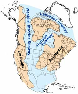
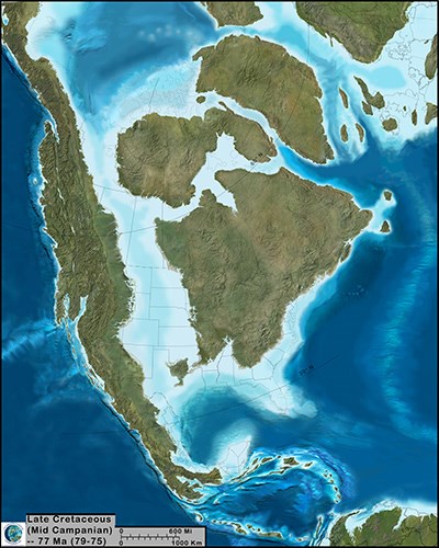
Deposition over large bodies of water as an alternative to the Flood is really funny since it is actually ... ... based on evidence.
quote: By google for Cretaceous inland sea images I find several showing different stages of innundations.
Based on evidence of sea plants and animals, fossil shorelines, etc. Enjoyby our ability to understand RebelAmericanZenDeist ... to learn ... to think ... to live ... to laugh ... to share. Join the effort to solve medical problems, AIDS/HIV, Cancer and more with Team EvC! (click)
|
||||||||||||||||||||||||||||||||||||||||||||
|
|
Do Nothing Button
Copyright 2001-2023 by EvC Forum, All Rights Reserved
![]() ™ Version 4.2
™ Version 4.2
Innovative software from Qwixotic © 2024