|

Understanding through Discussion |
|
|
Register | Sign In |
|
QuickSearch
| EvC Forum active members: 63 (9162 total) |
|
| |
| popoi | |
| Total: 916,363 Year: 3,620/9,624 Month: 491/974 Week: 104/276 Day: 1/31 Hour: 1/0 |
| Thread ▼ Details |
|
|
| Author | Topic: Introduction To Geology | |||||||||||||||||||||||||||||||||||
|
RAZD Member (Idle past 1424 days)  Posts: 20714 From: the other end of the sidewalk Joined: |
Hi Dr Adequate, thanks.
One of the other aspects of chemical weathering is that rocks form a crust over time, and the existence or absence of this crust can be used to determine if some stone artifacts have been worked or occur naturally. Relative thicknesses of this crust can also be used to form relative dating of exposed rocks. Enjoying your articles.by our ability to understand Rebel American Zen Deist ... to learn ... to think ... to live ... to laugh ... to share. Join the effort to solve medical problems, AIDS/HIV, Cancer and more with Team EvC! (click)
|
|||||||||||||||||||||||||||||||||||
|
Dr Adequate Member (Idle past 303 days)  Posts: 16113 Joined: |
I did briefly mention weathering rinds in the "how do we know" section.
Dating is a topic that I'll come to much later, in fact practically at the end.
|
|||||||||||||||||||||||||||||||||||
|
Dr Adequate Member (Idle past 303 days) Posts: 16113 Joined: |
Glaciers
Introduction A glacier is a mass of ice moving on the surface of the Earth. In this article, we shall discuss how glaciers form and move; we shall discuss the geological features associated with glaciers; and we shall show how recognizing these features can allow us to tell where glaciers have been in past ages of the Earth's history.
Formation and motion of glaciers A glacier forms at an accumulation point, that is, a place where more snow accumulates than melts. This snow then piles up and compacts under its own weight to form ice. Even if this happened on a perfectly level surface, as the ice mounted up it would eventually start to squidge outwards under the pressure of its own weight; and often glaciers will form on mountaintops, where gravity is also a factor. Under the effects of pressure and/or gravity, the ice will flow. A glacier flows in two ways: by sliding along its base, and by "plastic flow" of the molecules of ice within the glacier. You may recall from science class that ice tends to melt under pressure; this means that the base of a glacier is often lubricated by water. The overall speed of a glacier can be measured by simple methods: hammer a stake into a glacier, wait a while, come back, and see how far it's moved. The speeds so measured range from centimeters to meters per day, depending on the glacier. One significant different between the flow of ice and the flow of water is this: a river is pulled downwards by gravity. This happens to glaciers too, when flowing downhill; but glaciers are also pushed by the pressure behind them: as a result, glaciers can and do flow uphill. Once in motion, the ice in the glacier will keep flowing until it reaches a point where the ice ablates: either it reaches the sea, breaking up into bergs, or it reaches a zone where the climate is warm enough to melt the advancing glacier. In the latter case, the end of such a glacier represents an equilibrium state at which the rate of melting is just sufficient to balance the rate of flow of the glacier. Now, while this equilibrium is maintained, the glacier as a whole will stay still. The ice in the glacier moves, starting off at the accretion point and ending up at the ablation point, but the glacier as a whole stays in one place: it is like a conveyor belt of ice moving from accumulation to ablation. The length of the glacier will change with the climate: for example, if the climate gets warmer around the ablation end of the glacier, then the glacier won't be able to progress as far before reaching a zone in which the rate of melting equals the rate of flow, so the glacier will retreat (note that the ice in the glacier will still be moving forward while this is going on). Conversely, of course, a drop in temperature will let the glacier get further from the accumulation point. Changes at the accumulation site of the glacier will also affect its length: the more it snows at the accumulation point, the greater the volume of flowing ice, and the further it will get before it melts. It follows that global cooling will cause glaciers to extend further from accumulation points, and global warming will see them extend less far, or vanish entirely if they temperature rises so much that the snow melts at the former point of accumulation. Types of glacier A glacier originating where the snow accumulates on a mountaintop and flows down the mountain is known as a valley glacier or an alpine glacier: the terms are synonymous. The larger glaciers, such as can be found today covering the surface of Greenland and Antarctica, are known as continental glaciers, or sheet glaciers or ice sheets. Again, these are synonymous and the diversity of terms does not indicate that some sort of distinction is being drawn. Whereas valley glaciers flow downwards from the point of accumulation, the sheet glaciers of Greenland and Antarctica flow outwards in all directions from the point of accumulation.
Erosion associated with glaciers A glacier moving over a landscape will sweep up topsoil and loose rocks as it goes, transporting them towards the ablation end of the glacier and revealing the bedrock beneath. This bedrock will be polished by the passage of the ice over it; it will also be grooved and scored in the direction of travel by the rocks contained in the glacier: such groves are known as striations or striae, and the rocks are said to be striated. The picture below shows an example of striation:
The passage of a glacier will produce debris of all sizes, from enormous chunks of rock plucked from the bedrock to very fine rock flour produced by the grinding action of the glacier. A valley glacier will also carry along any rock fragments that fall from the valley walls. Some glaciers, known, reasonably enough as "rock glaciers" consist mostly of rocks cemented together by ice. One erosional feature commonly associated with glaciers is the roche moutone, caused when a glacier slides over a hummock of bedrock. As the glacier slides up the hill, it polishes and striates it; flowing down the other side, it plucks fragments from the rock, leaving a steeper and more ragged face in its wake. A valley glacier will created a bowl known as a cirque at the accumulation point, with about a quarter of the rim of the bowl missing in the direction in which the glacier eaves the cirque. A mountain eroded by glaciers will have a rugged, jagged topography, with knife-edge ridges where two cirques or glacial valleys adjoin. The valleys carved out by a valley glacier will have a characteristic U-shaped cross-section quite different from that produced by a river, which produces V-shaped valleys.
Deposition associated with glaciers The rock fragments transported and deposited by glaciers are known as till. It is unrounded and unsorted by size. This may not sound very remarkable, until we reflect that the action of wind or water cannot produce sediments like this: such an unsorted jumble of shards is characteristic of glacial action. In a valley glacier, there will be concentrations of till along the border of the glacier, where it has been plucked or ground from the valley sides. Such an accumulation of till is known as a lateral moraine. Where two valley glaciers meet, lateral moraines will merge into medial moraines in the middle of the larger glacier so formed, as shown in the aerial photograph below.
Ground moraine is till deposited over a wide area either when the till on the underside of the glacier lodges against something, or when a glacier retreats in response to climatic changes. Ground moraine is often found in small hills, shaped somewhat like the back of a spoon, known as drumlins. No-one is really sure how these form, but the fact that they are composed of till and found in conjunction with other signs of glacial action confirm that they are glacial in origin; also, they are invariably found oriented with their long axis in the direction of the flow of the glacier (as determined by study of striations, roches moutones, etc). At the ablation end of a glacier, the sediments transported by the glacier will be dumped to form an end moraine, resulting in a ridge of till in the same convex shape as the lobes typically found at the end of a glacier. Beyone the ablation zone, where the glacier melts, the water from it will be carried away, typically in a braided stream (a term which we shall explain in depth in our article on rivers). This will carry with it the lighter sediments, known as outwash, which will be deposited in front of the glacier as an outwash plain. One interesting sedimentary feature can be seen in lakes fed by glacial waters (proglacial lakes). In summer, relatively coarse outwash of sand and gravel will be deposited in these lakes; in winter, when the lake freezes over, the calm conditions below the ice allow fine particles of clay and of organic material to settle. The result is the formation of couplets of sedimentary material, one fine, one relatively coarse, repeated over and over, each couplet being known as a varve. Because the deposition of varves is an annual event, the study of varves is of interest in dating. Kettles are another feature we associate with glaciers. When a glacier retreats, we often observe that it leaves a large block of ice behind it. The outwash sediment from the retreating glacier will then build up around the orphaned block of ice. When it has melted, which may take many years, the result is a depression in the outwash plain: this is a kettle. If it lies below the water table, it will fill up to produce a small lake with outwash banks.
Former glaciers: how do we know? It is not difficult to detect the passage of a glacier, even if it is no longer present: for if you take away the glacier, you are still left with the patterns of deposition and erosion that glaciers produce; and these are highly distinctive and cannot be produced by other mechanisms. We may note that we can see glaciers disappearing today: for example, Glacier National Park in Montana has at the time of writing only 26 named glaciers, down from 150 in the year 1850; so our statements about what evidence former glaciers leave behind are by no means hypothetical, but rather are based on direct observation. With all former glaciers, whether valley glaciers or continental glaciers, we see characteristic patterns of erosion: we see such things as bedrock polishing, striation, roches moutones, and so forth. We also see till. As we have remarked, till is a very distinctive sort of sediment, which cannot be produced by the action of wind and water, as shown by its unsorted, unrounded nature. The arrangement of till can also be quite distinctive; a pile of till in a crescent-shaped end moraine admits of no other explanation except that a glacier deposited it there. The picture below shows a scene which any geologist would instantly recognize as glacial in origin: we are looking at the shallow (downstream) side of a striated roche moutone liberally scattered with glacial till.
Erratic boulders, when we find them, present another blatant clue. An erratic boulder is one which, in terms of the rock of which it is composed, has nothing in common with the geology of its surroundings, and which must have been transported to its present location over some distance; in some cases, hundreds of kilometers. Ice, as we can observe, can transport such enormous rocks; water and wind do not. We are therefore left with some unambiguous signs of former glaciers. When we see smoothed bedrock marked with striations leading to a semi-circular moraine of unrounded and unsorted rocks, many of them way out of their original geological context, beyond which is what looks suspiciously like an outwash plain, there is really no other conclusion that we can draw, except that we are looking at where a glacier once flowed and terminated. Besides the erosional and depositional features already mentioned, glaciers leave behind some highly distinctive landforms. Consider the for example the photograph below, taken in North Cascades National Park. There is no longer a glacier present, and, indeed, a lake has formed at the former accumulation point. (Such a lake is known as a tarn.)
Despite the absence of any actual ice, the reader should have no trouble in recognizing the landforms associated with a valley glacier, which are as clear and distinctive as an elephant's footprint. Here, surely, is the great bowl of a cirque, and just where we would expect to find it, near the peak where the temperatures are lowest; in the foreground, where the rim of the cirque is open, we see a valley with the distinctive U-shaped cross-section of a glacial valley, where the glacier once exited the cirque. Sheet glaciers do not carve out such distinctive forms, but they do leave large-scale clues behind. They often expose large expanses of bedrock. They also erase the drainage systems that were present in the landscape before their arrival, so that after they retreat, the landscape is poorly drained: such features are a sign to geologists to look for other indications of glaciation. We should mention a couple more signs of glaciation. The first of these is isostatic rebound. Ice is heavy: for reasons that we shall go into more thoroughly in our articles on tectonics, the weight of a continental glacier should press the crust of the Earth down into the mantle, and, when the glacier is gone, the Earth's crust should slowly "bounce" back up. This happens rapidly enough as to leave its marks over mere centuries: so, in parts of Scandinavia, we can see former harbors now standing uselessly distant from the sea. Today, the rate of rebound in post-glacial areas is measured directly by a GPS monitoring system called BIFROST: the maximum rate of rebound is about 1 cm/year. This on its own would not prove the former presence of glaciers, but in combination with the less ambiguous signs of erosion and deposition, the phenomenon of rebound does confirm the hypothesis of glaciation. There is one more prediction that we can make and confirm. We can use geological dating methods, of which more will be said in later articles, to establish the times at which sheet glaciers covered northern North America and Eurasia. Now, if we are correct in attributing these striations, moraines, and so forth to glacial action, then we ought to find that at the same time, we have other evidence of a colder climate, such as flora and fauna adapted to colder climates; lower sea levels caused by water being locked up in continental glaciers; temperature-dependent changes in the composition of shells; and so forth. And this is exactly what we do find, providing an independent confirmation of an ice age. We shall deal more fully with these topics in later articles on geological dating methods and on paleoclimatology; for now we shall simply note that these techniques can be used, and that they confirm what we can learn from studying landforms, sediments, and erosional features. Edited by Dr Adequate, : No reason given. Edited by Dr Adequate, : No reason given. Edited by Dr Adequate, : No reason given. Edited by Dr Adequate, : No reason given. Edited by Dr Adequate, : No reason given.
|
|||||||||||||||||||||||||||||||||||
|
Pressie Member Posts: 2103 From: Pretoria, SA Joined: |
Dr Adequate writes:
Thanks for your article Dr Adequate. It really is appreciated. We can use geological dating methods, of which more will be said in later articles, to establish the times at which sheet glaciers covered northern North America and Eurasia. A very large percentage of contributers to this forum are from North America (with a minority from Eurasia). Most of them don't realize we get similar conclusions on other continents and islands. What they don't realize is that the rocks on those continents and islands are studied, too. Africa, South America, Australia, Antartica, Indonesia, etc., observe similar phenonema, as well. (In India they get the same results as in the South Eastern parts of Africa, Western Australia and parts of Antarica when considering the occurrence of ice-sheets).
|
|||||||||||||||||||||||||||||||||||
|
Dr Adequate Member (Idle past 303 days) Posts: 16113 Joined: |
Africa, South America, Australia, Antartica, Indonesia, etc., observe similar phenonema, as well. (In India they get the same results as in the South Eastern parts of Africa, Western Australia and parts of Antarica when considering the occurrence of ice-sheets). I had the impression that it was much harder to do paleoclimatology in more distant geological periods (apart from saying: well, it must have been cold, look at all the evidence of glaciation) so when I was talking about the tie-in between dating and paleoclimatology, I restricted my remarks to the most recent Ice Age. I shall be mentioning glaciation on other continents when I discuss continental drift.
|
|||||||||||||||||||||||||||||||||||
|
Pressie Member Posts: 2103 From: Pretoria, SA Joined: |
We actually do have evidence for the last ice age (when the ice sheets covered most of North America and Eurasia), a few thousand years ago. Them rocks have no reason to tell porkies.
Edited by Pressie, : Couldn't say "lie", replaced it with "tell porkies".
|
|||||||||||||||||||||||||||||||||||
|
Dr Adequate Member (Idle past 303 days) Posts: 16113 Joined: |
We actually do have evidence for the last ice age (when the ice sheets covered most of North America and Eurasia), a few thousand years ago. Them rocks have no reason to tell porkies. This comment doesn't relate to my post. Of course we have evidence for a recent Ice Age, I've made that clear. Let's start again. My point at the end of the article was that we can look at things which are (claimed to be) evidence of glaciation and find some support for this claim by finding independent evidence that it really was very cold when this (supposed) glaciation took place. This is admittedly a minor argument when compared with the fact that it looks exactly like glaciation took place, but I thought it was worth mentioning as another converging line of evidence. When I raised this point, I specifically mentioned North America and Eurasia, i.e. I was talking about the most recent Ice Age(s). I know that there were other Ice Ages affecting other continents, but I didn't mention them. Why not? Because I have the impression (I may be wrong) that when we're looking at earlier geological periods, it is for technical reasons harder to find evidence of the cold independent of glaciation --- the best evidence that it was cold in (for example) East Africa during the Permian would be the evidence of glaciers. But I couldn't in this context adduce that as evidence that it was cold without involving myself in circular reasoning.
|
|||||||||||||||||||||||||||||||||||
|
Pressie Member Posts: 2103 From: Pretoria, SA Joined: |
That's fine Dr Adequate, I concede that you are right.
We do have other geological evidence for the last ice age. Edited by Pressie, : Added a sentence
|
|||||||||||||||||||||||||||||||||||
|
Minnemooseus Member  Posts: 3944 From: Duluth, Minnesota, U.S. (West end of Lake Superior) Joined: Member Rating: 10.0 |
...and in fact glaciers flow more swiftly near the top, as can be determined by hammering a flexible metal rod into a glacier and leaving it for a year or so: the rod will be bent at the top in the direction of flow. The glacial horizontal velocity is greatest at the top because the that is the sum of all the flowage from bottom to top, not because the the plastic flow at the top is the greatest. Plastic flow will approach zero as depth approaches zero. The below left is, as I understand it, your image of the bent rod (flow direction left to right); The below right is how I believe it would actually bend:
o              o
                           o                      o
                        o                            o
                      o                                o
                     o                                  o
o o Added by edit: The above right is also wrong - See message 72 for what I think is correct. Or something like that. Something to look at:
Source Moose Edited by Minnemooseus, : Change ID. Edited by Minnemooseus, : See above.
|
|||||||||||||||||||||||||||||||||||
|
Dr Adequate Member (Idle past 303 days) Posts: 16113 Joined: |
Yes, you're right, that sentence is a mess. I shall amend it, thank you.
|
|||||||||||||||||||||||||||||||||||
|
Dr Adequate Member (Idle past 303 days) Posts: 16113 Joined: |
The below left is, as I understand it, your image of the bent rod (flow direction left to right); The below right is how I believe it would actually bend:
o              o
                           o                      o
                        o                            o
                      o                                o
                     o                                  o
o o Or something like that. The ice at the top may have the lowest rate of flow, but doesn't it also have the highest velocity? --- In any case, I've just removed what I said for now. On reflection, I probably shouldn't have said it in the first place. I want to keep this series of articles as compact as possible, so I really shouldn't be talking about the physics or chemistry of any process unless it relates to the evidence that that process has taken place. Now whichever way the rod bends, it doesn't help us to determine whether some area of land was once subject to glaciation, so I have no idea why I brought it up. Edited by Adminnemooseus, : Put the "code" code in the quote box, to preserve raw formatting.
|
|||||||||||||||||||||||||||||||||||
|
Minnemooseus Member Posts: 3944 From: Duluth, Minnesota, U.S. (West end of Lake Superior) Joined: Member Rating: 10.0 |
First of all, I blotched the "bent rod" diagram. It should have been:
o
                           o
                            o
                              o
                                 o
o The horizontal displacement at the bottom is greater because the internal plastic flow is greater. The other diagram in message 69...
...illustrates the total displacement in a certain amount of time (the vertical velocity profile). As it says at diagram bottom: AC is total movement, AB is sliding at the glacier base, and BC is the internal plastic flow. Actually, the various BC's are summations of all the internal plastic flow from the base up to a given height. The vertical velocity profile line approaches vertical at the ice top surface because the plastic flow rate approaches zero.
The ice at the top may have the lowest rate of flow, but doesn't it also have the highest velocity? The top ice has the highest flow rate (velocity) relative to the base of the glacier (or in general, the fixed rock). That's because it is the sum of all the flow rates, bottom to top. You can't really see the vertical flow rate profile because it's buried in ice. You can see the lateral flow rate profile. But the essence of it all is that glaciers advance by some combination of basal slip and internal plastic flow. I believe that in some cases the glacier base can frozen to the rock below - There is no basal slip component. If there is no basal slip component, then there is also no erosion happening. By the way, glaciers retreat when the front ablation rate (melting etc.) exceeds the flow rate. The glacier does not start flowing the opposite direction. Moose Added by edit: I'm still not sure I didn't blotch up some of that plastic flow theory. Edited by Minnemooseus, : See above.
|
|||||||||||||||||||||||||||||||||||
|
Dr Adequate Member (Idle past 303 days) Posts: 16113 Joined: |
The horizontal displacement at the bottom is greater because the internal plastic flow is greater. But isn't it the total movement at a given depth that determines the displacement of the rod at that depth?
By the way, glaciers retreat when the front ablation rate (melting etc.) exceeds the flow rate. The glacier does not start flowing the opposite direction. I thought I'd made that quite clear. P.S: I did. It says: "if the climate gets warmer around the ablation end of the glacier, then the glacier won't be able to progress as far before reaching a zone in which the rate of melting equals the rate of flow, so the glacier will retreat (note that the ice in the glacier will still be moving forward while this is going on)". Edited by Dr Adequate, : No reason given.
|
|||||||||||||||||||||||||||||||||||
|
Dr Adequate Member (Idle past 303 days) Posts: 16113 Joined:
|
Deserts
Introduction In this article we shall discuss the forces that shape deserts, and discuss how geologists can use this knowledge to identify rocks that are the lithified remains of former deserts. We shall use some terms that have been introduced in previous articles on Sedimentary Rocks and Mechanical Weathering and Erosion; the reader who has not already read these articles may find it useful to go back and do so.
Causes of deserts The immediate cause of a desert is, by definition, lack of rainfall. This itself can have a number of causes, which are not mutually exclusive: an area can be a desert for more than one reason. * High-pressure deserts. In zones of high atmospheric pressure, the ability of air to contain moisture is increased, resulting in little rainfall. Examples include the Sahara, Arabian, Thar, and Kalahari deserts, and the desert regions within the Arctic and Antarctic circles. * Mid-continent deserts. Areas in the middle of a continent can receive little rainfall simply because rain, originating from evaporation of seawater, will tend to fall before it can reach the middle of a large continent. Modern examples are the Turkmenistan, Gobi, and Great Australian deserts (the Great Australian Desert is also in a region of high pressure). * Rain-shadow deserts. Rain will tend to break over mountains, so the presence of mountains can prevent rain from the sea from coming inland. Examples of rain-shadow deserts include the Mojave desert in the rain-shadow of the Sierra Nevada, the Patagonian desert in the rain-shadow of the Andes, and the Iranian desert in the rain-shadow of the Zagros mountains. * Upwelling deserts. Finally, a desert may be by the coast and not in the rain-shadow of any mountains, but be adjacent to where a cold current of water rises to the ocean surface, reducing evaporation. Examples include the Atacama desert, the Western Sahara, and the Namib desert; these are all also in high-pressure zones.
Deserts and water Although rainfall is rare in deserts, its effects are important in understanding the geology and ecology of deserts. It is characteristic of deserts that they exhibit internal drainage: that is, the water input to the desert in the form of rain or runoff from mountains does not flow out of the desert in the form of a river, but rather evaporates within the desert: this produces some highly typical depositional features.
Alluvial fans and bajadas. Deserts are often found associated with mountains: indeed, as we have seen, in some cases the mountains are the indirect cause of the desert. Runoff from rain on the mountains erodes them and transports the sediment downslope: when the sediment-rich water loses energy at the foot of the mountains, it forms a braided stream which rapidly deposits all but the lightest sediment in an alluvial fan (alluvial because it is formed by running water, and "fan" because this is the shape in which it is deposited). Two or more adjacent alluvial fans can merge to form what is known as a bajada. The photograph below shows an alluvial fan in Death Valley. The braided fanlike patterns made by the streams that deposited it are clearly visible.
Playa lakes. These are temporary lakes, which, being shallow and fed only by intermittent rainfall, dry up in the arid climate of the desert, leaving behind a flat, heat-cracked bed of clay, known as a playa. If the water contains any dissolved minerals these will be deposited on top of the clay layer as the water evaporates, leaving an evaporite bed of such minerals as halite, calcite, gypsum, borax, or trona, depending on the rocks that were their source. Repetition of this process builds up alternating layers of detrital and evaporite sediments. The photograph below shows the surface of a playa.
Oases. Oases are small lakes in the desert. These have a number of causes: they can be fed by springs; they can be deflation lakes, where erosion has caused a hollow the bottom of which lies below the water table; or they can be intermittent lakes filled by occasional rainfall and runoff.
Deserts and wind Deserts are the only places where wind is a major factor in erosion and deposition: soil bound by moisture and vegetation is harder for the wind to budge than loose, dry particles. Wind has a number of effects. First, it can remove the sand and other light particles from the surface. leaving bare rock or the stoney mosaic surface known as a desert pavement as shown in the photograph below.
Second, it can erode rocks by abrading them with the particles it carries: the photograph below shows the effects of wind erosion in a desert environment.
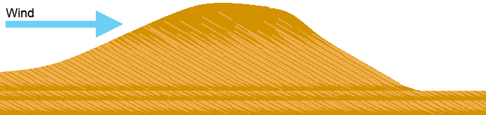
Thirdly, it can pile sand up into dunes, giving us our stereotypical image of a desert. A sandy desert is known as an erg. The dynamics and shapes of dunes vary depending on how variable the regional winds are. The animation below may however be considered a cross-section of a typical dune, lying with its long axis at right-angles to the direction of the wind. The wind transports the sand up the windward (stoss) side of the dune, to build up just over the crest of the downwind (lee) side of the dune. It accumulates until it reaches a critical angle at which it must avalanche, at which point the accumulated sand slides down the lee face of the dune to form a grainflow lamina.
The result of the transport of grains from stoss to lee is that the dune will move downwind. However, it will not always erode completely on the stoss side, instead leaving behind it a set of cross-beds composed of the bottom of the grainflow laminae, as we have shown in our diagram. Then the next sand dune to pass that way can deposit another discontinuous set of cross-beds on top of that set (and on top of any sand that may have been deposited by the wind between the passing of the two dunes). By this process, set after set of cross-beds build up. The cross-bedding is informative in a number of ways. First, it shows us that the sand was deposited in dunes: we shall discuss in the next section how we can determine that these dunes were caused by currents of wind and not water. Secondly, you will note from our diagram that the gradient of a grainflow lamina tends to become shallower at the bottom: this feature can be seen in the cross-beds in the photograph. Now, tectonic events are quite capable of turning rocks sideways or upside-down. The curves of the cross-beds are one of a number of features, known as way-up structures, that allow geologists to determine which way was originally up: the curves are concave in the up direction, convex in the down direction. In the case shown in the photograph, we can see that the sandstone is still the right way up. Thirdly, the crossbeds show us the prevalent direction of the winds, as we shall discuss later on in the articles on paleoclimatology.
Lithified deserts: how do we know? There are a number of features that we can use to identify sedimentary rocks that are the lithified remains of ancient deserts. In this section we shall review some of them. Desert sand is quartz, and the resulting sandstone will be quartz sandstone. This is not a definitive criterion for recognizing aeolian sandstone, since quartz sandstone can be formed under other conditions. We may, however, safely say that arkose sandstone or graywacke is not aeolian sandstone. Desert sands tend to be well-rounded, as a result of long abrasion, and well-sorted by size, and this is what we find in the grains of aeolian sandstone. Much, though not all, desert sand is colored, the grains being stained on the outside with iron oxides such as haematite, goethite and limonite, giving it a range of colors through red and orange to yellow. However, some desert sands are not stained in this way, so we cannot definitively say that sandstone lacking this feature is not desert sand. Cross-bedded features reveal transport by a current of wind or water. We can distinguish between the two cases by various features: for example, wind-formed dunes result in much bigger sets of cross-beds; also, aeolian sandstone uniquely exhibits pinstripe laminae, very narrow stripes only a few grains thick consisting of finer grains than are found in grainfall laminae. Playa deposits are extremely distinctive, and leave geologists no doubt that what they are looking at was once desert: they can only be formed by repeated episodes of deposition in and evaporation of a playa lake. Finally, we can look at the fossils, which, in a desert should be of land plants and animals, and of freshwater organisms in those rare places where the geology indicates a former oasis. No marine fossils should be found.
Case study: the Navajo sandstone As an example, consider the Navajo Sandstone of the southwestern United States, a formation which extends over 400,000 square kilometers of northern Arizona, northwest Colorado, Nevada, and Utah, and which is 600 meters thick at its thickest point. You can read about it here and here. * The sand, which is cemented together by calcite, silica, and haematite, is very pure quartz sandstone without clays or feldspars. * The sandgrains are well-sorted, consisting mainly of medium-sized grains; and well-rounded. The photograph below shows a microscopic view of grains in the Navajo sandstone that have been crumbled gently by hand from the surrounding matrix. On the left are medium-sized grains from a grainflow lamina; on the right are predominantly finer grains from a pinstripe lamina.
* In most of the Navajo sandstone, the grains are richly stained with iron oxides; this again can be seen in the photograph above. * The sandstone shows large cross-bedded features, of a type only observed to form in desert winds. The photograph showing crossbedded sandstone in the section on deserts and winds, above, is from the Navajo formation. * The sandstone exhibits pinstripe laminae, uniquely characteristic of aeolian sanddunes. * The sandstone contains layers of evaporites characteristic of playa lakes. * The sandstone contains no marine fossils, but instead contains fossils of land reptiles including Protosuchus, Ammosaurus, and Segisaurus. It contains fossilized footprints of land animals. It contains fossilized land plants including conifers, horsetails and ferns; root casts and stumps of trees can be found. * The land plants and animals and their footprints are found in association with rare thin interdune deposits consisting of lenses of limestone containing freshwater shells, indicating the presence of temporary freshwater oases (temporary, that is, in terms of a geological timescale); this is discussed here. In short, the Navajo sandstone was once a large sandy desert. Edited by Dr Adequate, : No reason given. Edited by Dr Adequate, : No reason given. Edited by Dr Adequate, : No reason given.
|
|||||||||||||||||||||||||||||||||||
|
Dr Adequate Member (Idle past 303 days) Posts: 16113 Joined:
|
Volcanic Ash
Introduction Volcanic ash is the name given to the fine particles of igneous rock produced by a volcano. As such, the name "volcanic ash" is a misnomer, since "ash" means a residue after incineration: the name is left over from times when people thought that volcanic ash really was ash. In this article we shall discuss the origin, transport, and lithification of volcanic ash, and as usual we shall consider how we can recognize volcanic ash, and its lithified counterpart (tuff) in the geological record. It will be helpful for the reader to have already read the main article on igneous rocks before reading this article.
Origin and dispersal of volcanic ash A volcanic eruption can throw off a fine spray of lava into the atmosphere as well as or instead of producing a cohesive lava flow. Because it originates as a fine spray, the droplets of lava often cool too rapidly to form a crystal structure; instead, they form an amorphous solid (a glass), although sometimes cooling may be slow enough for minerals to form. Sometimes the ejecta will also include particles of material torn by the eruption from the solid rock forming the volcano. Collectively, these fine airborne particles are the constituents of volcanic ash. These particles can be distributed in two different ways. If the volcano is sufficiently forceful, it can throw the volcanic ash high into the air, where it will be distributed by wind. Particles transported in the way can travel great distances: for example, ash from the eruption of Krakatoa was carried all the way to the island of Sumatra. Alternatively, the ejected material can be transported in a pyroclastic flow. In this case, the ash-filled air is denser than the surrounding air because of its load of ash, and for this reason mixes poorly with the surrounding air, and so can travel over great distances (200 kilometers or more) before finally dissipating. The current can travel particularly far if it finds its way into a pre-existing channel such as a river valley.
Tuff Lithified volcanic ash is known as tuff. This comes in two varieties. Welded tuff has its origins when the beds of volcanic ash, when they form, are hot enough for the clasts to compact and weld together. Cemented tuff is produced by the same cementing mechanism that cements together the clasts of coarse-grained sedimentary rocks such as sandstone.
Volcanic ash: the igneous sediment Volcanic ash is, obviously, an igneous rock: it comes out of volcanoes, and you can hardly get more igneous than that. However, in many ways it behaves like a sediment. As geologists say, it's "igneous when it goes up, and sedimentary when it comes down." For one thing, volcanic ash consists of small clasts, just like other sediments; also, as we have seen, it can undergo cementation just like the process that cements together sand grains to make sandstone. The image below is a scanning electron microscope image of a single clast from the eruption of Mt. St. Helens.
Another feature that makes volcanic ash sedimentary in nature is that it can form graded beds like a sediment, with smaller particles on top. If the ash is shot high into the air, then the larger particles, the mass of which is better able to overcome air resistance, will settle first. If, on the other hand, the ash is transported by pyroclastic flow, then again the ash will still grade upwards from coarse to fine: as the current disperses and fails, the size of the particle that it can transport decreases, and so at any particular point in its path the particles that it deposits will decrease in size. (However occasionally, depending on the behavior of the volcano, the flow can also increase in speed, leading to inverse grading.) Finally, ash beds resemble other sediments because they are a good place to find fossils. Inhaling volcanic ash tends to shred the lungs of animals, and if the ash bed is reasonably thick the bodies will undergo rapid burial, leaving them well-preserved. However, volcanic ash is also igneous, and for this reason displays a number of features that make it of special interest to geologists. A particular volcanic eruption is a single event at a particular point in time: when we see a horizontally continuous layer of volcanic ash, we know that it was all laid down at the same time, and whatever is immediately beneath it was a snapshot of the landscape as it was just before the eruption. Such a geological feature is known as an event horizon. This is by no means true of sedimentary rocks in general. Just because you have a continuous horizontal stratum of, for example, sandstone, this does not necessarily mean that the beds at one end were laid down at the same time as the beds at the other end, as we shall discuss in a later article. Furthermore, each volcanic eruption has its own chemical signature: the exact mix of chemicals in one volcanic eruption will be different from another. This means that even if a layer of volcanic ash is not exposed everywhere, so that we cannot directly observe that it is a single layer, we can still check whether two exposed areas of volcanic ash do or don't belong to the same eruptive event. Finally, unlike sedimentary rocks, volcanic ash and the rocks that form from it can be dated directly.
Volcanic ash and tuff: how do we know? It takes no subtle chain of reasoning to know that volcanic ash or tuff found in the geological record is indeed volcanic ash or tuff. For when a volcano erupts, we can watch volcanic ash beds being formed: and the beds in the geological record look like that. This appearance is even more evident under the microscope. In the photograph below we show a photomicrograph of welded tuff, where the clasts have been squashed and welded together (the larger, white fragments are broken crystals included in the ash). Note the distinctive shape of the clasts: no-one looking at welded tuff under a microscope could mistake it for anything but welded tuff.
Finally, we may note that since ash and tuff are igneous in origin they have a chemical composition that lies on the usual felsic-ultramafic spectrum of igneous rocks: so we may speak of "rhyolite ash" or "basaltic tuff". So chemically there can be no doubt that volcanic ash and tuff are igneous in origin: but the fact that they are clastic means that we can't confuse them for any other sort of igneous rock. These considerations mean that geologists can be confident of identifying volcanic ash and tuff when they find them in the geological record. Edited by Dr Adequate, : No reason given. Edited by Dr Adequate, : No reason given.
|
|||||||||||||||||||||||||||||||||||
|
|
Do Nothing Button
Copyright 2001-2023 by EvC Forum, All Rights Reserved
![]() ™ Version 4.2
™ Version 4.2
Innovative software from Qwixotic © 2024


 (1)
(1)