|

Understanding through Discussion |
|
|
Register | Sign In |
|
QuickSearch
Summations Only | Thread ▼ Details |
|
Thread Info
|
|
|
| Author | Topic: Why the Flood Never Happened | |||||||||||||||||||||||||||||||||||||||||||||
|
RAZD Member (Idle past 1427 days)  Posts: 20714 From: the other end of the sidewalk Joined: |
But you say there are differences between the Palouse and the GC as uf that should be news to me. Didn't I say that myself? What is the cause for the differences Faith -- why are they different? and not a little different they are a lot different.
Sorry RAZD I can't follow that post. Look at the detail the the Grand Canyon map -- the lines are lines of constant elevation at 25 meter (~82 foot) intervals. The bunched lines show where it is steep (cliffs) and the spaced lines show where it is flattish (plateaus) and you can see the meanders in the cliffs as well as the river. Enjoyby our ability to understand Rebel American Zen Deist ... to learn ... to think ... to live ... to laugh ... to share. Join the effort to solve medical problems, AIDS/HIV, Cancer and more with Team EvC! (click)
|
|||||||||||||||||||||||||||||||||||||||||||||
|
RAZD Member (Idle past 1427 days) Posts: 20714 From: the other end of the sidewalk Joined:
|
It's either too big or too small. Big I can make out topological lines but only in very small sections at a time, small I can't make out those lines at all. hold down key and hit the <+> key to make bigger or the <-> key to make smaller. Scroll around to follow the river -- you can use arrow buttons or the window slide buttons.
but here is a .png that Jon made from it:
If you download it (save as) then it won't be popping back and forth between big and small. Spend some time on the tributaries too, not just the canyon, particularly Meadow Creek the big one to the south -- how does it still connect and flow into the Grand Canyon when it would be running uphill with the uplift? Enjoy Edited by RAZD, : frack coding thanks Jonby our ability to understand Rebel American Zen Deist ... to learn ... to think ... to live ... to laugh ... to share. Join the effort to solve medical problems, AIDS/HIV, Cancer and more with Team EvC! (click)
|
|||||||||||||||||||||||||||||||||||||||||||||
|
RAZD Member (Idle past 1427 days) Posts: 20714 From: the other end of the sidewalk Joined:
|
Yes, that makes a major difference in how the two areas were sculpted. Stiill damp sedimentary layers would carve a LOT easier than basalt, accounting for the huge width and depth of the GC. Still damp sediments don't form cliffs either. It's that nasty angle of repose question that Atheos canadensis keeps asking ...
Again, you can't compare a worldwide Flood to "a flood." Again, this ain't standard "flood flow." Again, this is basic hydrodynamics. But not applicable to this particular scenario. Why not Faith -- because it doesn't work? What makes water behave differently for you than for the rest of the world?
The idea here is this: ... My best guess is ... ... I'm just spelling out my version ... ... seems to me ... ... according to my version of the YEC view, ... That's how I'm getting that the water flowed in from all sides ... But not what the evidence shows. Opinion and guessing have been shown to have very little effect on reality.
In this case the water at the bottom had to flow into the cracks because that's where the cracks were. Fill the tub with water and then pull the plug. The bottom water runs out first. ... Ah ... nope. The water flows down to the drain from directly over it. It will form a 'whirlpool' where the top waters will go down the drain before the water at the very bottom. Try putting drops of ink in the water and seeing what really happens. Again this is basic hydrodynamics and is well documented. Top water is always faster moving because there is less friction there. The deeper water is the more pressure there is, the more pressure there is the more friction there is resisting movement -- even for water particles against water particles. So again it comes down to energy gradients
The water that was standing over the whole stack of strata would find its way into those cracks, just as it was doing up in the Grand Staircase area too and indeed all over the Southwest. ... So it was violently going nowhere?
The water was starting to drain away, west and south from this area, and the whole canyon length must have been cracked in the upper strata and the water flowed west and eventually out into California. There is an east-west slope too and the water from the western area would have started flowing away already so the more easterly water followed suit. Where did it go? The usual theory is that the sea floor dropped at the end of the Flood and that's where all the water went. And you can model this and see that the flow would be entirely different under that scenario. Water over the top of the grand canyon rims would flow in the direction of least resistance to the depressed area, with top water flowing first. And we have an example of this with the Palouse river post glacier flood over-topping the ridge between the Palouse and the Snake river and wearing it away to change course directly to the Snake river. That this did not happen at the Grand Canyon means that your fantasy did not happen.
... and cracks developed on the south side of the mound running east-west. Probably very LONG cracks ... The water that was standing over the whole stack of strata would find its way into those cracks ... And then it would sit there while the waters above flowed south and east. There are underwater cracks all over the world and flow doesn't magically happen in them. What make the water flow Faith?
... but the water exited west and eventually, weeks later? months later? years later? centuries later? settled down to a river, a fast and deep powerful river at first, then much later the river we now see. Which is, curiously, exactly the flow pattern in the Palouse river, but the canyon shape is quite different ... why again is that? Enjoy.by our ability to understand Rebel American Zen Deist ... to learn ... to think ... to live ... to laugh ... to share. Join the effort to solve medical problems, AIDS/HIV, Cancer and more with Team EvC! (click)
|
|||||||||||||||||||||||||||||||||||||||||||||
|
RAZD Member (Idle past 1427 days) Posts: 20714 From: the other end of the sidewalk Joined:
|
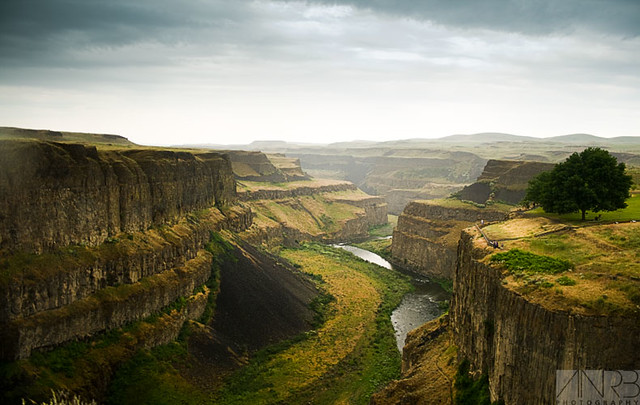
Se also the channeled scablands which you have ignored so many times. Or the Palouse river that cut through basalt forming a U shaped channel just like the U shaped channel from Mt St Helens:
One is harder than the Grand Canyon rock and one is softer than the Grand Canyon rock, yet both show the same U shaped channel due to catastrophic cascading flow ... the sides of the canyons are different because of the different materials, the wide flat bottom is due to the hydrodynamics of catastrophic cascading flow. So, Faith, you are boxed in by evidence that contradicts your thinking. Notice that in both cases we have a meandering stream left in the catastrophic cascade canyons. There are flat areas in the Grand Canyon that could support catastrophic cascading flow to some degree, however you still have over 1000 feet of V-shaped canyon down to the current river level, geography that supports gradual erosion of this section of the canyon, where the cliffs follow the meanders of the river that has incised into the rock to these depths. For your scenario, the meandering stream could only form after the catastrophic cascade finished and after the river "settled down" (if you can call historic spring flow "settled") ... so any incising of the canyon bottom would be done by standard erosion of sandstone and limestone rock, already lithified -- according to your fantasy -- by the flood pressure which is now gone with the catastrophic cascade flows ... Here are four cropped portions of the big topomap detailing this:
And you still need a long period of erosion to get that deep. In lithified rock ... ... because (a) your mechanism for lithifying the rock is now gone away and (b) the cliffs are too vertical for non-lithified deposits. Enjoy. Edited by RAZD, : clrty Edited by RAZD, : added meandering stream Edited by RAZD, : gc img Edited by RAZD, : added Edited by Admin, : Reduce image width. Edited by RAZD, : .by our ability to understand Rebel☮American☆Zen☯Deist ... to learn ... to think ... to live ... to laugh ... to share. Join the effort to solve medical problems, AIDS/HIV, Cancer and more with Team EvC! (click)
|
|||||||||||||||||||||||||||||||||||||||||||||
|
RAZD Member (Idle past 1427 days) Posts: 20714 From: the other end of the sidewalk Joined: |
You've got in both cases a VERY LOW WALL OF SEDIMENT compared to the miles deep stack of the GC. Sorry, no comparison. Exactly, Faith, very good, glad you noticed that ... because that is HOW catastrophic cascading flow erodes -- it makes a wider canyon than it is deep because the sides are easier to erode than the bottom. That is why the Grand Canyon cannot have been formed this way. And don't try to use cracks to explain it -- the Palouse cut-off followed a fault line through the ridge ... and still made a wide flat bottomed channel. Everything you say happened we can find evidence of ... the problem (for you) is that they don't look like the Grand Canyon because it didn't form that way. Enjoy.by our ability to understand Rebel American Zen Deist ... to learn ... to think ... to live ... to laugh ... to share. Join the effort to solve medical problems, AIDS/HIV, Cancer and more with Team EvC! (click)
|
|||||||||||||||||||||||||||||||||||||||||||||
|
RAZD Member (Idle past 1427 days) Posts: 20714 From: the other end of the sidewalk Joined:
|
JonF - I believe she is talking about the layers that made the staircase cliffs
So they were stacked up way over the top of the canyon rim, causing the sediments to lithify, and then they were eroded by the catastrophic cascade while they were still wet before lithifying and then the river deep into the still unlithified sediment but as soon as the sides were exposed they litified due to all that weight that is now gone ... do try to keep up. Enjoy Edited by RAZD, : piclinkby our ability to understand Rebel☮American☆Zen☯Deist ... to learn ... to think ... to live ... to laugh ... to share. Join the effort to solve medical problems, AIDS/HIV, Cancer and more with Team EvC! (click)
|
|||||||||||||||||||||||||||||||||||||||||||||
|
RAZD Member (Idle past 1427 days) Posts: 20714 From: the other end of the sidewalk Joined:
|
I'm just trying to fit your concepts into real geology Faith
Since lithification is apparently a technical term, I'd rather say "hardened." verb (used with object), lithified, lithifying.1. to change (sediment) to stone or rock. hardened[hahr-dnd] Show IPA adjective 1. made or become hard or harder. 2. pitiless; unfeeling. 3. firmly established or unlikely to change; inveterate: a hardened criminal. 4. inured; toughened: a hardened trooper. 5. rigid; unyielding: a hardened attitude. Doesn''t appear to be a geological term, but there is a hardness test used by engineers to categorize the properties of various materials. What hardness are you thinking of?
But well-hardened from the compression of sediments above. That aren't there anymore so there is no additional hardening -- so they should be in the state we see today ... rock that takes a long time to erode. As soon as you start your erosion scenario your "hardening" scenario is de facto finished, caput, ended, and no longer applicable because all those over layers are now gone. You can't just pretend that the material world changes behavior to suit you, whether it is water or sediment or rock.
No, I never said they lithified when exposed, you are making things up. They were already hardened enough not to slump, but quite easily sculpted by rushing water. ... and by every other source of erosion -- wind, rain, seeping groundwater, freeze-thaw cycles ... anything easy to carve will have an angle of repose that is less than the canyon walls. In fact you can see many places where erosion of the sediments follows that nasty unforgiving angle of repose between sections of vertical rock ... these occur as the sides collapse as the river cuts deeper. Easy to cut also means easy to fracture, to break into smaller pieces and fall down until an angle of repose is built up. It doesn't work Faith. Enjoyby our ability to understand Rebel American Zen Deist ... to learn ... to think ... to live ... to laugh ... to share. Join the effort to solve medical problems, AIDS/HIV, Cancer and more with Team EvC! (click)
|
|||||||||||||||||||||||||||||||||||||||||||||
|
RAZD Member (Idle past 1427 days) Posts: 20714 From: the other end of the sidewalk Joined:
|
There are many rivers in this world that are a lot more powerful than the Colorado that didn't even begin to cut a canyon. There is no way that river in its current form cut that canyon. The difference being ... {drumroll} ... uplift. That river in its current form eroded through three (3) lava dams ... Enjoy.by our ability to understand Rebel American Zen Deist ... to learn ... to think ... to live ... to laugh ... to share. Join the effort to solve medical problems, AIDS/HIV, Cancer and more with Team EvC! (click)
|
|||||||||||||||||||||||||||||||||||||||||||||
|
RAZD Member (Idle past 1427 days) Posts: 20714 From: the other end of the sidewalk Joined:
|
The canyon meanders. How do you reconcile this with your model, Faith? Your continued silence on the matter is proof that you know just as we do that such a reconciliation is impossible. Actually the bottom of the canyon shows extensive incised meanders within the overall canyon boundaries ... that also meander more than a catastrophic cataclysmic cascade could cause:
These three detail sections almost overlap in the portion of the canyon from Meadow Creek (seen in the right hand detail) west. The cliffs shown by closely packed topo lines are over 1000 feet high, and they follow the meanders of the river below, thus they are incised for that depth. This meandering would only occur after Faith's river "settled down" to normal behavior, after the rocks had gotten as hard as they could get before the overlying sediment was removed, rocks that had to be as hard as they are today because there is no other means to harden them except long geological processes. These portions of the canyon of cliffs closely following the meandering river can only occur after all of Faiths frantic fantasy hand waving has finished. And there is no more time to dig this deep a channel in the rocks we see today. Faith also has not explained Meadow Creek to me yet. It flows into the Grand Canyon from the south through land that rises to the south rim. Enjoy. Edited by Admin, : Reduce image width. Edited by RAZD, : piclinksby our ability to understand Rebel☮American☆Zen☯Deist ... to learn ... to think ... to live ... to laugh ... to share. Join the effort to solve medical problems, AIDS/HIV, Cancer and more with Team EvC! (click)
|
|||||||||||||||||||||||||||||||||||||||||||||
|
RAZD Member (Idle past 1427 days) Posts: 20714 From: the other end of the sidewalk Joined: |
correct, but don't confuse Faith with facts ...
 Edited by RAZD, : Enjoyby our ability to understand Rebel American Zen Deist ... to learn ... to think ... to live ... to laugh ... to share. Join the effort to solve medical problems, AIDS/HIV, Cancer and more with Team EvC! (click)
|
|||||||||||||||||||||||||||||||||||||||||||||
|
RAZD Member (Idle past 1427 days) Posts: 20714 From: the other end of the sidewalk Joined: |
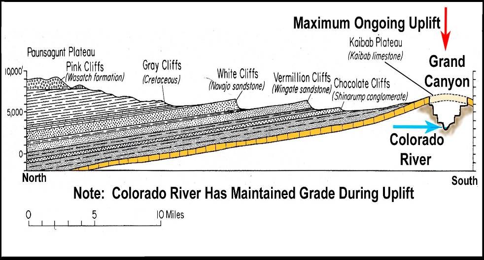
The falls exist because of uplift. It's an extreme example of what happens on the downriver side of an uplift. Both the downriver and upriver side get eroded away. And because there are different layers with different "hardness" ... from that slide show again:
And we can measure the erosion rate for the falls to move upriver and see where it has been and then calculate how low it took to get to where it is today. Enjoy.by our ability to understand Rebel American Zen Deist ... to learn ... to think ... to live ... to laugh ... to share. Join the effort to solve medical problems, AIDS/HIV, Cancer and more with Team EvC! (click)
|
|||||||||||||||||||||||||||||||||||||||||||||
|
RAZD Member (Idle past 1427 days) Posts: 20714 From: the other end of the sidewalk Joined:
|
... I'd post some pictures of my own but I still haven't figured out how to do it so I'll link as usual to my blog where I've posted them. You've been here some 12 years and you haven't figured out how to post pictures? Steps:
Leave no spaces between the dbcodes and the picture urls Or you could peek at my codes below
And now you cannot say that I haven't taught you anything ... Enjoyby our ability to understand Rebel American Zen Deist ... to learn ... to think ... to live ... to laugh ... to share. Join the effort to solve medical problems, AIDS/HIV, Cancer and more with Team EvC! (click)
|
|||||||||||||||||||||||||||||||||||||||||||||
|
RAZD Member (Idle past 1427 days) Posts: 20714 From: the other end of the sidewalk Joined:
|
I'm still sort of waiting for an "aha" moment to hit some Old Earthers about this. Aha! Hoodoos were carved by wind and by freeze/thaw cycles, not water. And thus they are evidence of extended dry periods rather than floods. Enjoy.by our ability to understand Rebel American Zen Deist ... to learn ... to think ... to live ... to laugh ... to share. Join the effort to solve medical problems, AIDS/HIV, Cancer and more with Team EvC! (click)
|
|||||||||||||||||||||||||||||||||||||||||||||
|
RAZD Member (Idle past 1427 days) Posts: 20714 From: the other end of the sidewalk Joined: |
I do strongly agree that it would help a great deal if Faith could somehow come to understand that what scientists think is based upon evidence, not speculation. Another thing to emphasize is that no sedimentary layer (AFAIK) covers the entire earth -- they all have bare spots, and this also flies in the face of her flood layering concept. (in addition to the sorting problem which no creationist will tackle). Enjoy.by our ability to understand Rebel American Zen Deist ... to learn ... to think ... to live ... to laugh ... to share. Join the effort to solve medical problems, AIDS/HIV, Cancer and more with Team EvC! (click)
|
|||||||||||||||||||||||||||||||||||||||||||||
|
RAZD Member (Idle past 1427 days) Posts: 20714 From: the other end of the sidewalk Joined: |
... What's really needed is what HBD showed on a diagram a while back, a depth of erosion that cuts into lower layers, and lots of it making a mess of the horizontal impression even at a great distance. ... Why? Why should a channel mess up other areas Faith? Or are you saying there should be multiple channels? This was posted by DrA in Message 518:
The red layers are covered by dark gray layers which are covered by light gray layers ... These layers all slant up from right to left ... The top is irregular cutting across these layers from right to left ... and near the left end it dips down far into the dark gray layer. Why doesn't this satisfy you that erosion occurred? Enjoy.by our ability to understand Rebel American Zen Deist ... to learn ... to think ... to live ... to laugh ... to share. Join the effort to solve medical problems, AIDS/HIV, Cancer and more with Team EvC! (click)
|
|||||||||||||||||||||||||||||||||||||||||||||
|
|
Do Nothing Button
Copyright 2001-2023 by EvC Forum, All Rights Reserved
![]() ™ Version 4.2
™ Version 4.2
Innovative software from Qwixotic © 2024


 (1)
(1)