|

Understanding through Discussion |
|
|
Register | Sign In |
|
QuickSearch
| EvC Forum active members: 64 (9164 total) |
|
| |
| ChatGPT | |
| Total: 916,839 Year: 4,096/9,624 Month: 967/974 Week: 294/286 Day: 15/40 Hour: 1/3 |
Summations Only | Thread ▼ Details |
|
Thread Info
|
|
|
| Author | Topic: Why the Flood Never Happened | ||||||||||||||||||||||||||||||||||
|
herebedragons Member (Idle past 885 days)  Posts: 1517 From: Michigan Joined: |
No, it's what I've been complaining about as a VIOLATION of the physical laws of the universe, and even go on to object to in that same post you are answering here. It makes absolutely NO sense to me that water would cut deeper into upraised land, NONE whatever. Let me see if I can make sense of this part of it for you. Let's start with a river flowing over a flat plain. It is 24" deep (average), 25' wide and flowing at a rate of 1000 cu. ft./ min. It would have a velocity of 20 ft./ min. Now, imagine an area of the river uplifts 6". At that point the water would only be 18" deep but would retain to same width of 25' and the same flow rate of 1000 cu. ft./ min. This would mean that the velocity would have to increase to 26.6 ft./ min to maintain that same flow rate. This would be a 33% increase in velocity and would provide 33% more energy for erosion of the up-lifted portion. It would also increase the sediment load to the downstream portion (since erosion rates have increased at the uplift) and increase erosion of the downstream section somewhat as well. Now once the uplifted section is eroded level, the section uplifts again and the cycle repeats. Do this several times and the uplifted portion will eventually be above the original water level, but the river bottom will remain level with the portion that has not been uplifted. Yes, if the uplift occurred faster than the river could down-cut, it would eventually create a dam that the river would have to go around, or build up behind until it breached the dam. So it doesn't violate the physical laws of the universe, it relies on the physical principal that faster moving water has more energy than slower moving water.
YOU KNOW, ONE THING IT WOULD BE REALLY GOOD TO HAVE FOR THIS DISCUSSION, AND I'VE LOOKED FOR IT FROM TIME TO TIME, IS A REALLY CLEAR TOPOGRAPHICAL MAP OF THE COLORADO PLATEAU. I'VE SEEN A LOT OF THEM BUT IT'S HARD TO GET A FEELING FROM THEM FOR THE DIFFERENT ALTITUDES OF DIFFERENT LOCATIONS. The problem is that the area is enormous! You can find really good topo maps of areas of the canyon, but to make a map that is viewable on your computer screen requires that the map scale be quite high and so, not very usable in this context. One of the best sources for topo maps is the USGS. You can download free PDF files here at the USGS Store. Navigate to the GC area, change the selection to "MARK POINTS", place a mark at the point you want a map of, then click on the marked point to view available maps. Then select the map you want to download. I downloaded the GC 1984 30x60 grid. HBDWhoever calls me ignorant shares my own opinion. Sorrowfully and tacitly I recognize my ignorance, when I consider how much I lack of what my mind in its craving for knowledge is sighing for. But until the end of the present exile has come and terminated this our imperfection by which "we know in part," I console myself with the consideration that this belongs to our common nature. - Francesco Petrarca "Nothing is easier than to persuade people who want to be persuaded and already believe." - another Petrarca gem.
|
||||||||||||||||||||||||||||||||||
|
RAZD Member (Idle past 1432 days)  Posts: 20714 From: the other end of the sidewalk Joined: |
The second part of this makes sense, great, "ONCE INCISED" it's just going to cut deeper, great. So far so good ... Good.
... but if over time meanders on a plain build the river level higher with deposits as that quote I posted claims, I'm no longer sure about all this. Those deposits occur when the water floods over the banks and the flow slows down. This is how flood plains develop in flat areas, this is why flood plains are fertile soils, because of the depositing of fine materials (particles smaller than sand). These would be seasonal occurrences (spring floods, Nile river monsoon floods, etc)
But the first part is still like something from down the rabbit hole. How can UPLIFT "instigate" headcutting? This sort of thing is said all the time here and just threatens to make my head explode. Say I do an experiment like the one in the video with the large box of dirt (I wish I could do that sort of thing), and I get a little river running across a flattish surface (I'd first wet it and pack it hard so the water wouldn't dig into it the way it did in the video), having fun watching it make meanders etc. Say the box is suspended by cables and I can crank up the whole box to lift it to a higher level. I am NOT going to get that little river cutting more deeply into the dirt. Or do you say otherwise? You would need to tilt it a little bit to ensure the flow crosses the box. With a little trial and error you could find a slope that allow the water to flow across the surface but doesn't erode it. You would also need to play with the flow rate to find the point where it would meander rather than just flow straight down. Your "thought experiment" problem is that you are simply lifting the whole enchilada so that doesn't really model what happens at the boundary of the uplift. You need to divide your box in two and then lift one an inch or two compared to the other to create a small waterfall\erosion zone. This should erode the bottom from that point upstream similar to what is shown in the video, but it may not get all the way to the other end of the box yet -- with homogeneous material (sand) it will cut the top of the erosion hot spot faster than the base and end up with a sloped bottom from the lift point to the upstream end of the box. The bottom of the channel will erode until it reaches the point where is is flat enough that erosion does not occur anymore, and this could be steeper than the slope you started with as there could be a range of slopes below which the erosion doesn't occur and where meanders occur. The material that is eroded from the first (upstream) box will either be deposited in the second (downstream) box in a delta like manner, deposited along the flow as it meanders across the lower box (creating oxbows), or carried through the second box (depending on the slope of the box and the water flow rate). Lift the first box another inch and the process will continue. With several repeats you should be able to incise the upstream section across the box. You can also do it with three hinged panels so that as the upstream end is lifted the middle section gets tilted to a greater slope creating a sloped erosion zone. This should still result in an incised channel from the tilted section upstream and a delta or flat meandering stream that spreads deposits out in the lower section.
And certainly if the uplift occurs in the path of a river so that there is an incline the river would have to climb to keep its path, it's not going to run along the uplift at all but around it, or pool up in front of it. If it were a point uplift and that occurred before the meander were incised I would agree. If it were a ridge uplift across the path of the river then it would cause the water to collect on the upstream side until it reached a level it could flow over the crest of the ridge. This could be modeled with the 3-section hinged box by lifting the upstream hinge if the box sides are tall enough to contain the water behind the ridge. Again it is possible that with the whole apparatus tilted to the maximum slope where meandering occurs that a small lift of the hinge area would still leave the upstream side with a downslope for the water to flow over. This should create an erosion zone at the hinge such that you can continue to lift the hinge slowly and the water will continue to cut through and erode back down while the side at the hinge lift zone become incised. Follow?  Now your box model just became a little more difficult.by our ability to understand Rebel American Zen Deist ... to learn ... to think ... to live ... to laugh ... to share. Join the effort to solve medical problems, AIDS/HIV, Cancer and more with Team EvC! (click)
|
||||||||||||||||||||||||||||||||||
|
Percy Member  Posts: 22499 From: New Hampshire Joined: Member Rating: 4.9
|
Here's a topological map of Arizona:
--Percy
|
||||||||||||||||||||||||||||||||||
|
RAZD Member (Idle past 1432 days) Posts: 20714 From: the other end of the sidewalk Joined: |
Lake waters would not gather in an uplifted region, and there's no evidence of a lake ever overlaying the entire Grand Canyon area. Austin's "Lake" is based on filling the land up to the ridge rim and flooding both sides. The "lake" is then the area east of the ridge, but the plan shows water on both sides.
This requires water flowing uphill into the Glen Canyon area. And what about the canyons upstream from Glen Canyon in Canyonlands National Park in Utah? And what about the canyons upstream from that in Colorado? Your lake that releases a catastrophic flow needs to be higher in elevation than all the canyons it supposedly creates, which puts it atop the Rockies. It fills up to Page and the Powell Dam and then merges with Lake Powell in the plan that I saw, and fills in a little over that. He doesn't "uncut" Glen Canyon so it is just not mentioned\considered as far as I can see.
Faith Message 1389: ...apparently picturing it draining away completely into the canyon from about its center. If you think of it that way you could have it completely filling up something like Glen Canyon before draining away and leaving that canyon there. This does not explain the formation of Glen Canyon.  by our ability to understand Rebel American Zen Deist ... to learn ... to think ... to live ... to laugh ... to share. Join the effort to solve medical problems, AIDS/HIV, Cancer and more with Team EvC! (click)
|
||||||||||||||||||||||||||||||||||
|
herebedragons Member (Idle past 885 days) Posts: 1517 From: Michigan Joined: |
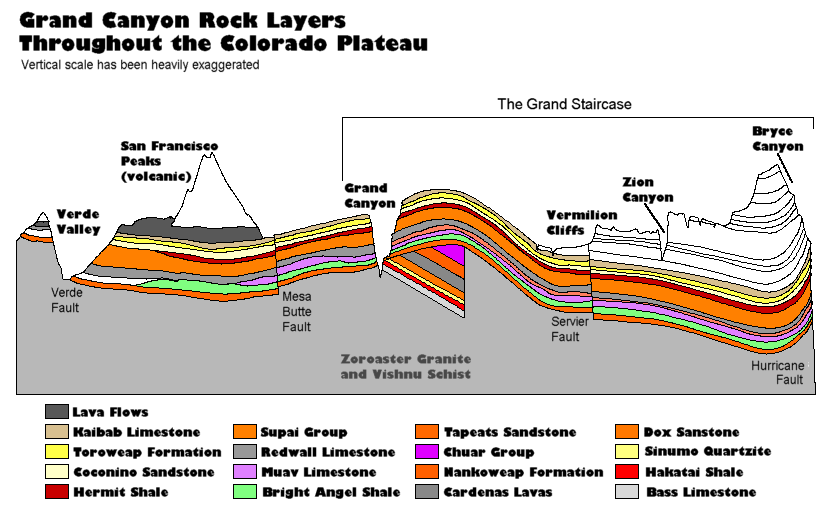
BEFORE THE REGION WAS UPLIFTED, first we have the strata laid down FLAT for thousands of square miles, I understand what you have been trying to say regarding this point, but it is simply wrong. Why is the Coconino 65 feet thick at one end, 600 feet thick in the middle and 57 feet thick on the other end? Not flat. Why is the Tempe Butte limestone 100 feet thick to non-existant? Not flat. Why does the Mauv limestone end abruptly near the Mesa Butte fault and the underlying Bright Angel Shale contact the Redwall limestone above it? Not flat. Why does the Hermit Shale end near the San Francisco peaks as does the Bright Angel Shale? Not flat. And include the erosional features between the layers that have been pointed out numerous times. Not flat. What you seem to have difficulty wrapping your head around is how such deep sediments could have been laid down. How could there be a build up of a mile or two of sediment unless there was two or three miles of water initially? What you need to consider is that the continental crust floats on the underlying mantle and as weight is added it can sink into the mantle. At some point, the crust becomes weaker since the underlying metamorphic rocks are incorporated into the mantle and volcanic activity occurs. We observe these phenomenon today and it explains the features well.
If you look at this image again and consider the questions I asked above, then draw your diagram based on actual thicknesses of the layers. Maybe draw one layer at a time so that the top of each layer is flat when laid down, I think you will find a trend towards the area forming a basin as subsequent layers are formed. Finally, there is no reason why an area cannot go for a long period of time without major orogenies. Why do you think there MUST be a major orogeny in the Grand Canyon stack prior to the uplift? HBDWhoever calls me ignorant shares my own opinion. Sorrowfully and tacitly I recognize my ignorance, when I consider how much I lack of what my mind in its craving for knowledge is sighing for. But until the end of the present exile has come and terminated this our imperfection by which "we know in part," I console myself with the consideration that this belongs to our common nature. - Francesco Petrarca "Nothing is easier than to persuade people who want to be persuaded and already believe." - another Petrarca gem.
|
||||||||||||||||||||||||||||||||||
|
herebedragons Member (Idle past 885 days) Posts: 1517 From: Michigan Joined: |
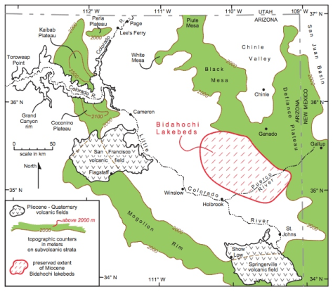
Austin's "Lake" is based on filling the land up to the ridge rim and flooding both sides. The "lake" is then the area east of the ridge, but the plan shows water on both sides. It appears the both Austin and the geologist in the video the shalamabobbi presented in Message 1297 simply used the contour lines on a map such as Percy presented (not sure of the elevation) to establish the boundaries for these giant lakes. The main problem I see is that there is a much easier exit for the waters just north of the Arizona border where highway 89 runs between Big Water and Kanab. Which is what you have brought up several times ... Why is there no canyon there? Another problem is the evidence for Lake Bidahochi (Lake Hopi) is much more restricted than what they are saying. It certainly is not a "megalake", at least according to the known deposits.
Also, in the video, he mention that the Bidahochi deposits were green shale (?) which can only be laid down in deep water. But everything else I have read about Lake Bidahochi suggests it was very shallow and ephemeral. Who is right? What do you think about this guy's explanation for the formation of the canyon? He incorporates Lake Bidahochi, but doesn't make it the central player. It seems to give the cutting process a boost in the early stages. HBDWhoever calls me ignorant shares my own opinion. Sorrowfully and tacitly I recognize my ignorance, when I consider how much I lack of what my mind in its craving for knowledge is sighing for. But until the end of the present exile has come and terminated this our imperfection by which "we know in part," I console myself with the consideration that this belongs to our common nature. - Francesco Petrarca "Nothing is easier than to persuade people who want to be persuaded and already believe." - another Petrarca gem.
|
||||||||||||||||||||||||||||||||||
|
JonF Member (Idle past 195 days) Posts: 6174 Joined: |
YOU KNOW, ONE THING IT WOULD BE REALLY GOOD TO HAVE FOR THIS DISCUSSION, AND I'VE LOOKED FOR IT FROM TIME TO TIME, IS A REALLY CLEAR TOPOGRAPHICAL MAP OF THE COLORADO PLATEAU. Previously posted: http://www.fleming-group.com/Misc/GC/GCT.html. Scroll with the arrow keys, zoom with the + and - keys. Edited by JonF, : No reason given.
|
||||||||||||||||||||||||||||||||||
Faith  Suspended Member (Idle past 1472 days)  Posts: 35298 From: Nevada, USA Joined: |
BEFORE THE REGION WAS UPLIFTED, first we have the strata laid down FLAT for thousands of square miles,
I understand what you have been trying to say regarding this point, but it is simply wrong. Why is the Coconino 65 feet thick at one end, 600 feet thick in the middle and 57 feet thick on the other end? Not flat. Why is the Tempe Butte limestone 100 feet thick to non-existant? Not flat. Why does the Mauv limestone end abruptly near the Mesa Butte fault and the underlying Bright Angel Shale contact the Redwall limestone above it? Not flat. Why does the Hermit Shale end near the San Francisco peaks as does the Bright Angel Shale? Not flat. Oh good grief, do I REALLY have to say "RELATIVELY FLAT" every single time I describe this obvious fact? There is no reason why the layers would have had to be PERFECTLY flat for crying out loud. Do I HAVE to point out every place where a sediment comes to an end and layers connect and disconnect in odd ways? Yes I KNOW all that. I don't expect the Flood to have created perfection in its layering, why do you? It's really remarkable that it is as consistent as it is. Far more consistent than could possibly be explained on the ridiculous OE scheme. You guys can make a problem out of ANYTHING for the creationist, making a big production out of a gnat-sized problem, while swallowing a camel if it's an Old Earth claim of course.
And include the erosional features between the layers that have been pointed out numerous times. Not flat. There are NO erosional features that occurred at the surface of the earth for millions of years.
What you seem to have difficulty wrapping your head around is how such deep sediments could have been laid down. I have NO problem with this, where are you getting this idea?
How could there be a build up of a mile or two of sediment unless there was two or three miles of water initially? This I have thought about. Why do you assume I haven't? I figure it represents roughly the depth of the land mass that was there before the Flood being redeposited in the form of segregated strata. The water was to rise a certain height above the land mass. I assume it did so.
What you need to consider is that the continental crust floats on the underlying mantle and as weight is added it can sink into the mantle. At some point, the crust becomes weaker since the underlying metamorphic rocks are incorporated into the mantle and volcanic activity occurs. We observe these phenomenon today and it explains the features well. And your point is?
If you look at this image again and consider the questions I asked above, then draw your diagram based on actual thicknesses of the layers. Maybe draw one layer at a time so that the top of each layer is flat when laid down, I think you will find a trend towards the area forming a basin as subsequent layers are formed. That is absolute nonsense. Loose or waterborne sediments are not going to form a basin when laid down one on top of another. They are going to form a horizontal surface no matter what is beneath them; a deposition would fill in any basin if it existed beneath it. In other words they are going to follow GRAVITY, which so many here seem to forget exists. There is no reason to try to reflect every variation in the depth of a particular layer.
Finally, there is no reason why an area cannot go for a long period of time without major orogenies. I don't use the word "orogeny" because I don't think it's about mountain building per se. I don't believe the Great Unconformity was ever the base of a mountain range. I'm talking simply about TECTONIC MOVEMENT. If you believe the time table given for the building of the strata from the Great Unconformity up through the top of the Grand Staircase you come to I think Dr. A said 700 or so million years, but it's in the hundreds of millions anyway. That's a LONG time between tectonic movements. AFTER all the strata were laid down THEN we get what is usually called the "Laramide Orogeny" which is the NEXT tectonic movement after the one that supposedly created the Great Unconformity, again on the OE timetable, those hundreds of millions iof years later, and this time we get all the visible disturbances on the cross sections, the UPLIFT, the MAGMA INTRUSIONS such as the one that issues in the lava field at the top of the Grand Staircase, the FAULT LINES, the CUTTING of the cliffs/stairs and canyons in the GS as well as the Grand Canyon itself.
Why do you think there MUST be a major orogeny in the Grand Canyon stack prior to the uplift? I'm observing the facts on the cross section, I never said there MUST be anything of the sort. You ought to KNOW that's what caused the uplift, nothing else could have. SOMETHING had to cause the disturbances described above to have occurred after all the strata were in place and tectonic movement had to be the cause. And again, although I believe it DID push up the Rockies and DID uplift the GC region I think it gets across its effects better to call it tectonic movement rather than "orogeny." Oh but I guess you are really asking why I think there should have been tectonic movement during all those hundreds of millions of years between the two recognized "orogenies?" The answer is that I believe geologists simply haven't noticed that their timetable requires that tectonic activity DIDN'T occur for such a long time because they assume this is an active planet and all kinds of disturbances are going on all the time, which is in fact stated at the beginning of the video shalamabobbi posted. I'm the one noticing that their timetable requires this hiatus in the supposed very active activity of the planet, I don't think Old Earthers have noticed the implications of their own timetable. Once it's pointed out then everybody indignantly claims it's perfectly normal to expect such a long time of no activity. Well, go back and watch the first minute of that video: this is an ACTIVE PLANET, you know, with lots of ONGOING activity all the time. Rox did say in response to this idea that she agrees and that there must have been such activity during those hundreds of millions of years and she supposed it occurred but wasn't reflected on the cross section. Edited by Faith, : No reason given. Edited by Faith, : No reason given. Edited by Faith, : No reason given.
|
||||||||||||||||||||||||||||||||||
|
Tanypteryx Member  Posts: 4443 From: Oregon, USA Joined: Member Rating: 5.0 |
Hi Faith,
I have been wondering why there are so many distinctly different layers of sediment from your flood? I would expect a world wide flood that was supposedly carrying this huge load of material to have deposited one huge layer of sediment uniformly world wide. I would think it would have all the largest, densest material at the bottom grading to finer and finer material at the top. This is what hydrology and physics tells us to expect. Instead, we get dozens of layers of completely different materials and no uniformity world wide. In the American SW we see a lot of these layers exposed in the various canyons, and cliffs, but really, nothing I have seen resembles the simplistic cross section drawings that you seem to like.
Not only are the vertical and horizontal scales way off, but the only erosional and other disturbance features shown are the canyons and some uplift. Why are there so many distinct layers and why they are ordered the way they are, with sandstone on top of limestone and then more limestone and then maybe shale and so on. Why wouldn't all the sandstone and all the limestone, etc. be deposited together? Maybe you explained this and I missed it.What if Eleanor Roosevelt had wings? -- Monty Python One important characteristic of a theory is that is has survived repeated attempts to falsify it. Contrary to your understanding, all available evidence confirms it. --Subbie If evolution is shown to be false, it will be at the hands of things that are true, not made up. --percy
|
||||||||||||||||||||||||||||||||||
|
Atheos canadensis Member (Idle past 3025 days)  Posts: 141 Joined: |
I've had in mind that the water hadn't yet reached its zenith, why do you assume otherwise? I never said such a thing. And I still can't fathom your silly idea about violating superposition. I get so impatient with this kind of nonsense I just can't stick around to try to figure it out, it makes NO sense, and it's obviously just another of the dozens and dozens of objections and accusations by overactive imaginations, a lot of it plain ridiculous, that I have coming at me all the time here. Why should I take yours seriously? Faith, I appreciate that fact that you try to answer many posts from many posters. I am less impressed by the fact that you only tend to do so until you run out of counterarguments and then declare it irrelevant. I will clearly state the law of superposition and succinctly explain why it is a problem for you, that way you won't have to spend time understanding. I do this trusting that your confusion is sincere and not merely a evasive fabrication. The law of superposition basically sates that strata lower in section were deposited before and are older than the strata that are higher in section. The Problem: The dinosaur is preserved undisturbed in terrestrial deposits. The only way that works with the Flood model is if it were buried at the very start of the Flood. But it appears near the top of the rock record, no near the bottom which one would expect if it had been deposited at the start of the Flood. Do you see the problem? Please explain what you don't understand about this and I will clarify. The same problem applies to trackways. Trackways appear throughout the record, including the very uppermost layers. Are you claiming that there was still ground available to be walked upon in the very last stages of the Flood? That doesn't sound very biblical.
|
||||||||||||||||||||||||||||||||||
|
Faith Suspended Member (Idle past 1472 days) Posts: 35298 From: Nevada, USA Joined: |
Let's start with a river flowing over a flat plain. It is 24" deep (average), 25' wide and flowing at a rate of 1000 cu. ft./ min. It would have a velocity of 20 ft./ min. Now, imagine an area of the river uplifts 6". At that point the water would only be 18" deep but would retain to same width of 25' and the same flow rate of 1000 cu. ft./ min. What guarantees that after being reduced to a depth of 18 inches it would retain the same width and the same flow rate? The lower six inches of the river now have the task of climbing the six inch slope or being backed up at that point and swelling the river behind it. Doesn't that do something to the flow rate? If it doesn't, at least it increases the volume of the river behind the slope. If it has high banks then I suppose the width can be counted on to remain more or less the same but at some point this backing up could cause the earlier part of the river to exceed the banks as the thwarted lower six inches WILL add up. Do you see what I'm saying?
This would mean that the velocity would have to increase to 26.6 ft./ min to maintain that same flow rate. Uh huh, the velocity "would have to increase" IN ORDER TO "maintain that same flow rate," sure, but who says the flow rate must be maintained and what is going to make the velocity increase? I would expect that the upper 18 inches of the flow would just go on flowing at its usual rate since it's level and there's nothing to impede it yet, but speed up? Don't see how. I don't see how the flow rate could possibly be maintained at this point. Seems to me we have a modified dam situation here and there's still that lower six inches that isn't getting over the slope and has to be backing up the upstream part of the river as described above. So if the volume increases back there, then we have a deeper river higher on its banks, and the part going over the slope is going to be deeper too, and that should affect things somehow, but I'm not sure in much of a positive direction for the antigravity theory being proposed here. That lower six inches is still not getting over that slope and still backing up etc. I'd have to have some big boxes of dirt to play in to check all this out but it looks like what you've done is simply assume that SINCE the velocity would have to increase to maintain the same flow rate, that somehow that actually happened, although there is no way on known principles of physics that could be the case.
This would be a 33% increase in velocity and would provide 33% more energy for erosion of the up-lifted portion. "Would be" of course. But also couldn't be on this planet.
It would also increase the sediment load to the downstream portion (since erosion rates have increased at the uplift) and increase erosion of the downstream section somewhat as well. Again, of course: IF.
Now once the uplifted section is eroded level, the section uplifts again and the cycle repeats. Do this several times and the uplifted portion will eventually be above the original water level, but the river bottom will remain level with the portion that has not been uplifted. Uh huh, again IF. But as I say above I see no reason to assume the velocity is going to increase, I see nothing that would make that happen. Therefore the flow rate is going to decrease, not increase as it goes over the uplift, and the water is going to back up and swell the upstream part of the river, very likely to the point of overflowing its banks, which is what I'd expect of the effect of a barrier in the path of a river, even a low barrier. There is not going to be any increase in erosion of the uplifted river bottom. There COULD be a build-up of sediment in front of the slope, however, since it isn't going to be able to get up the slope, that's something to think about. Well, you're a true child of this forum, HBD, defying gravity with aplomb. Edited by Faith, : No reason given.
|
||||||||||||||||||||||||||||||||||
|
Faith Suspended Member (Idle past 1472 days) Posts: 35298 From: Nevada, USA Joined: |
ABE: Oh sorry, I thought this post was by HBD, now I see it was Tanypteryx. Well, please ignore references to HBD.
===============
I have been wondering why there are so many distinctly different layers of sediment from your flood? I would expect a world wide flood that was supposedly carrying this huge load of material to have deposited one huge layer of sediment uniformly world wide. Well SURE you would, HBD, as does everybody who FIRST encounters the idea, which is obviously your situation. But water DOES layer sediments. This is seen in river deltas and even in the oceans. It is also seen in various experiments designed to demonstrate it. See Berthault experiments. You can also make beautiful layers of coffee and cream by pouring the cream very carefully into a glass of coffee, or the other way around I forget, something to do with principles of suspension in liquids. Do I know exactly how the Flood did the layering, of course not, but I do know that water DOES layer sediments and that the Old Earth scenario that attaches a time period of millions of years to a particular sediment is idiotic.
I would think it would have all the largest, densest material at the bottom grading to finer and finer material at the top. This is what hydrology and physics tells us to expect. Uh huh, of course you would, the guy who thinks a river is going to speed up when it encounters an upward slope. And again I don't know how the Flood sorted it all, I just know there is no other REASONABLE explanation for how it IS sorted.
Instead, we get dozens of layers of completely different materials and no uniformity world wide. In the American SW we see a lot of these layers exposed in the various canyons, and cliffs, but really, nothing I have seen resembles the simplistic cross section drawings that you seem to like. Um, watch that video shalamabobbi posted way back there now. In just about every frame there is a shot of the Grand Canyon showing its obvious original horizontality -- I say "original" because clearly it's been eroded and sometimes broken and slumped since it was laid down but it was ORIGINALLY horizontal, which is what is seen on the cross sections. In fact original horizontality is a PRINCIPLE OF GEOLOGY. And why should there be any uniformity to the layers across the world anyway? Where do you get such expectations of what a worldwide Flood would have done? Cross sections ARE simplistic but unless they are really really bad they should reflect what is actually there and since every one I've seen agrees with every other I think we can count on that much. Edited by Faith, : No reason given. Edited by Faith, : No reason given. Edited by Faith, : No reason given. Edited by Faith, : No reason given. Edited by Faith, : No reason given.
|
||||||||||||||||||||||||||||||||||
|
Faith Suspended Member (Idle past 1472 days) Posts: 35298 From: Nevada, USA Joined: |
But the first part is still like something from down the rabbit hole. How can UPLIFT "instigate" headcutting? This sort of thing is said all the time here and just threatens to make my head explode. Say I do an experiment like the one in the video with the large box of dirt (I wish I could do that sort of thing), and I get a little river running across a flattish surface (I'd first wet it and pack it hard so the water wouldn't dig into it the way it did in the video), having fun watching it make meanders etc. Say the box is suspended by cables and I can crank up the whole box to lift it to a higher level. I am NOT going to get that little river cutting more deeply into the dirt. Or do you say otherwise?
You would need to tilt it a little bit to ensure the flow crosses the box. With a little trial and error you could find a slope that allow the water to flow across the surface but doesn't erode it. You would also need to play with the flow rate to find the point where it would meander rather than just flow straight down. I would expect to aqccomplish that by keeping the box level but simply patting the dirt into a very slight slope from top to bottom. I did have that in mind.
Your "thought experiment" problem is that you are simply lifting the whole enchilada so that doesn't really model what happens at the boundary of the uplift. No, but in the original statement nothing was said about the boundary, the whole message is simply that "uplift instigates headcutting." But OK, let's assume the boundary part was unintentionally excluded. So really you are dealing with the same situation I just answered HBD about. This river is flowing along and it encounters an UPSLOPE. ABE: But in this case I'd expect it to lose its meanders altogether. To get the meanders to incise shouldn't the whole meandering part of the river be uplifted? Never mind, I suppose this is what you have in mind preserving by hinging the box. But unfortunately now I'm SO lost I think you do have to start over. Sorry /ABE.
You need to divide your box in two and then lift one an inch or two compared to the other to create a small waterfall\erosion zone. Or I'd simply build half the wet packed dirt an inch or two higher than the other half so that the water flowing from the lower level will eventually encounter the higher. I assume I'd be building a gradual slope up to the higher level as well.
This should erode the bottom from that point upstream similar to what is shown in the video, This I don't see. In the video the water wasn't dealing with an upward slope, it was simply eroding upstream across a plateau. In fact one thing that was odd about that video was that it didn't take into account that there would have been an upslope onto the uplift that the river would have had to encounter as it came down from the Rockies; it had the river running down and across the plateau with no upward slope at all in its path. ABE: It also showed no meanders although the plateau was shown as fairly flat /ABE
but it may not get all the way to the other end of the box yet -- with homogeneous material (sand) it will cut the top of the erosion hot spot faster than the base and end up with a sloped bottom from the lift point to the upstream end of the box. This is where a diagram or an animated graphic would be helpful because I'm really not getting the picture here at all. Also I wouldn't use sand, it would have to be "dirt," mostly clay I suppose, so that it would pack hard when wet. Anyway I'm not getting your picture at all and since you seem to be describing what happens when a river encounters an upslope I can't see the animated graphic in the video as applying at all.
The bottom of the channel will erode until it reaches the point where is is flat enough that erosion does not occur anymore, and this could be steeper than the slope you started with as there could be a range of slopes below which the erosion doesn't occur and where meanders occur. The material that is eroded from the first (upstream) box will either be deposited in the second (downstream) box in a delta like manner, deposited along the flow as it meanders across the lower box (creating oxbows), or carried through the second box (depending on the slope of the box and the water flow rate). Lift the first box another inch and the process will continue. With several repeats you should be able to incise the upstream section across the box. You can also do it with three hinged panels so that as the upstream end is lifted the middle section gets tilted to a greater slope creating a sloped erosion zone. This should still result in an incised channel from the tilted section upstream and a delta or flat meandering stream that spreads deposits out in the lower section. Too bad, I'm completely lost now. I didn't expect you to keep up the separate boxes idea, the waterfall erosion idea doesn't seem to fit the situation of a river's having to climb a slope, and the whole picture you are pursuing just isn't working.
And certainly if the uplift occurs in the path of a river so that there is an incline the river would have to climb to keep its path, it's not going to run along the uplift at all but around it, or pool up in front of it.
If it were a point uplift and that occurred before the meander were incised I would agree. If it were a ridge uplift across the path of the river then it would cause the water to collect on the upstream side until it reached a level it could flow over the crest of the ridge. This could be modeled with the 3-section hinged box by lifting the upstream hinge if the box sides are tall enough to contain the water behind the ridge. Yes, or I could just build the ridge into the dirt.
Again it is possible that with the whole apparatus tilted to the maximum slope where meandering occurs that a small lift of the hinge area would still leave the upstream side with a downslope for the water to flow over. This should create an erosion zone at the hinge such that you can continue to lift the hinge slowly and the water will continue to cut through and erode back down while the side at the hinge lift zone become incised. Since the whole picture has become so confused I think I have to ask you to start over again if you would please. But I would comment at this point that hyour expectation that an erosion zone would be created at the hing such that by slowly lifting the higher level even higher "the water will continue to cut through and erode (back down) while the side at the hinge lift zone becomes incised" sounds to me like it's the same kind of impossible gravity-defying scenario HBD was describing. But again, there's too much confusion in the picture here to conclude much about it. First you have to prove that coming to an upslope would cause the river to do that waterfall erosion thing. I don't see how that would happen. The water is moving in the wrong direction for that. And if it did happen and the river bed kept being eroded upstream that would only make it harder for the water to navigate the upslope that was encountered.
Follow? Sorry, no, as said above.
Now your box model just became a little more difficult. Changing the terrain which requires the hinged sections already makes it more difficult than I wanted it to be but that part's not the problem as much as the rest of what you've said. Edited by Faith, : No reason given. Edited by Faith, : No reason given. Edited by Faith, : No reason given. Edited by Faith, : No reason given. Edited by Faith, : No reason given. Edited by Faith, : No reason given.
|
||||||||||||||||||||||||||||||||||
|
Faith Suspended Member (Idle past 1472 days) Posts: 35298 From: Nevada, USA Joined: |
The law of superposition basically sates that strata lower in section were deposited before and are older than the strata that are higher in section. Of course.
The Problem: The dinosaur is preserved undisturbed in terrestrial deposits. The only way that works with the Flood model is if it were buried at the very start of the Flood. Totally lost me. Please describe the "terrestrial deposits," sandstone I presume, and explain why on earth that would mean it would have to be buried at the very start of the Flood.
But it appears near the top of the rock record, no near the bottom which one would expect if it had been deposited at the start of the Flood. Do you see the problem? Please explain what you don't understand about this and I will clarify. Do not see the problem, as explained above.
|
||||||||||||||||||||||||||||||||||
|
Faith Suspended Member (Idle past 1472 days) Posts: 35298 From: Nevada, USA Joined: |
Since I happened to mention this phenomenon in a post above I thought it would be nice to find an illustration of it. I couldn't find one of the sort I had in mind but I did find a discussion of the phenomenon itself, by somebody who also took a picture of his glass of coffee after he'd poured milk into it and it made the distinct layers I was talking about.
He was astonished by it but I used to frequent an espresso caf run by Italians, long before Starbucks existed, where they prided themselves on pouring their lattes and macchiatos with beautiful layers in clear glass, and they did a much better job of it than the picture this guy links to, often creating many thin distinct layers of beautifully graded shades, and I also think, but I can't prove this, that the gradations weren't necessarily in order from top to bottom but varied throughout the glass. That may not be a true memory, don't know, but thought I'd mention it. Also, the discussion on that site about how temperature difference causes the layering is wrong because you make lattes and macchiatos with hot espresso plus hot steamed milk. I think it must simply have to do with the different weight or other qualities between milk and coffee. What this phenomenon may or may not have to do with water's layering of sediments I'm not going to speculate, but it does seem to suggest there might be some connection for at least some situations. Edited by Faith, : No reason given. Edited by Faith, : No reason given.
|
||||||||||||||||||||||||||||||||||
|
|
Do Nothing Button
Copyright 2001-2023 by EvC Forum, All Rights Reserved
![]() ™ Version 4.2
™ Version 4.2
Innovative software from Qwixotic © 2024