|

Understanding through Discussion |
|
|
Register | Sign In |
|
QuickSearch
| EvC Forum active members: 66 (9164 total) |
|
| |
| ChatGPT | |
| Total: 916,471 Year: 3,728/9,624 Month: 599/974 Week: 212/276 Day: 52/34 Hour: 2/1 |
| Thread ▼ Details |
|
Suspended Member (Idle past 1466 days)  Posts: 35298 From: Nevada, USA Joined: |
|
Thread Info
|
|
|
| Author | Topic: Evidence that the Great Unconformity did not Form Before the Strata above it | |||||||||||||||||||||||
Faith  Suspended Member (Idle past 1466 days) Posts: 35298 From: Nevada, USA Joined: |
Done so already. And what is your model anyway? Just a bunch of suppositions looks like to me.
|
|||||||||||||||||||||||
|
Faith Suspended Member (Idle past 1466 days) Posts: 35298 From: Nevada, USA Joined: |
This is an ordeal with a malfunctioning space bar. Must have splashed something on it.
Anyway.
The "upper sequence" being the horizontal strata above the vertical? But it certainly IS that battered: those rocks are barely a shadow of their former selves, nothing left but splinters basically.
And how do you know their 'former selves'? They are sandstone strata aren't they? Have you ever seen sandstone deposited in such a fragmented splintery condition?
But that's not even the point here. The point is that if the weathering is so severe at the unconformity, why is there anything left of the uppermost layers? Odd question seems to me. How long would you expect it to take? Wouldn't there have been more sandstone there that got eroded down to this level?
Think of it this way. Why is the uppermost dashed yellow line still intact? If you were correct, it should be battered to tiny splinters and scattered across the North Sea. It has simply been eroded DOWN to this level in the last 4500 years, sandstone over and around it being slowly weathered away, leaving this pathetic splintery bunch of rock.
By the way, I have outlined in blue some clasts of the lower sequence within the upper. How do you suppose they got there? That's like the quartzite boulder embedded in the Tapeats back at the GC. It represents the zone of abrasion between upper horizontal and lower folded strata in MY model of what happened, pieces of the lower formation ending up in the lowest part of the upper.
And surely there was once a huge stack of strata above them too, just as in the GC, long since destroyed by tectonic and other forces.
And all of the time they were eroded, they were protecting the unconformity at this point... Yes, but on my model that wouldn't have been long as I think the tectonic and volcanic activity that destroyed them occurred in the last stage of the Flood, as the water was receding. After that some strata was left, probably somewhat more than we see here now, and in much better condition, at which point the harsh weather went to work on it.
And do try to remember: I don't think of each bedding plane as having been exposed for any great period of time.
Then neither has the unconformity been exposed to the elements for a great period of time. Correct, only thousands of years rather than millions. Enough to make quite a wreck of it but not enough to reduce it to dust yet.
|
|||||||||||||||||||||||
|
Faith Suspended Member (Idle past 1466 days) Posts: 35298 From: Nevada, USA Joined: |
As for the rest of your post and previous posts, they are pretty much self-serving, fantastic, unconstrained nonsense Speaking of there being no reason to continue this ridiculous discussion.... Edited by Faith, : No reason given.
|
|||||||||||||||||||||||
|
Faith Suspended Member (Idle past 1466 days) Posts: 35298 From: Nevada, USA Joined: |
Because people could potentially spend a lot of time responding to what they believe to be your position, it would be very helpful if you could clearly identify when we've accurately understood you. Trying again, your position is that the exposed cliff face that we see today at Siccar Point that shows a very uneven boundary between layers was once deeply buried inside the cliff face, and that before a great deal of rock was eroded away by severe weathering that the boundary that used to be visible was much more straight. And to be clear about what you're not saying, your position is not that we're looking at pretty much the same rock today (the same cliff face) at Siccar Point that we were looking at a couple hundred years ago, but that it was much straighter then. If I'm getting you, yes, I'm saying that the presently "exposed cliff face" was eroded after being exposed. But as I was looking at your version of the picture you marked with the straight line I began to doubt that edge had identified the lower strata correctly anyway. Some of it looks like it belongs in the eroded zone above it. Edited by Faith, : No reason given.
|
|||||||||||||||||||||||
|
Faith Suspended Member (Idle past 1466 days) Posts: 35298 From: Nevada, USA Joined: |
Most of that is off topic.
|
|||||||||||||||||||||||
|
Faith Suspended Member (Idle past 1466 days) Posts: 35298 From: Nevada, USA Joined: |
Faith writes: If I'm getting you, yes, I'm saying that the presently "exposed cliff face" was eroded after being exposed. But what you've just said, that the cliff face was eroded after being exposed, isn't what people are taking issue with. If that's all you were really saying then everyone would agree with you because every exposed surface is always being eroded, it only being a matter of degree. We're trying to understand what you think happened to transform this from a couple hundred years ago: ...Into this today (ignore the blue outlined area): There are two options: 1.The part of the boundary exposed a couple hundred years ago happened to be straight. In the couple hundred years since, the cliff face has eroded back a number of feet, enough to expose a different part of the same boundary, one that happens to be much more uneven. 2.The cliff face we see today is basically the same one as a couple hundred years ago. In the couple hundred years since, severe weathering has caused the straight boundary to deform and become very uneven Or is it something else. Please let us know. Hard to follow so many different options. But I'll just try to state more clearly what I had in mind. The drawing I posted I believe represents accurately what was actually there: Distinct upper horizontal and lower vertical sections with a straight contact line. To explain edge's photo of the irregular contact line I figure the upper section was partly eroded away from the lower, could be a matter of inches rather than feet but I'm not sure of the scale, exposihg the upper surface of the lower strata to weathering which has made it irregular over the last couple hundred years. ABE: So, rereading, I think your option 2 is closest but it needs the exposure of the upper surface of the cliff face brought about by erosion of the upper section. Edited by Faith, : No reason given. Edited by Faith, : No reason given.
|
|||||||||||||||||||||||
|
Faith Suspended Member (Idle past 1466 days) Posts: 35298 From: Nevada, USA Joined: |
But even if the yellow line were redrawn as you would like, it would still be uneven, right? Somewhat but not a lot.
|
|||||||||||||||||||||||
|
Faith Suspended Member (Idle past 1466 days) Posts: 35298 From: Nevada, USA Joined: |
I spent a little time on that photo and came up with the following: the only part of the lower section that remains above the straight line you drew is the small piece to the right of the dike. My own squiggly yellow line falls below yours. I also outlined in lt. blue the zone that looks more like erosion than like either of the strata sections.
'
Edited by Admin, : Remove the URL from the image - it makes zooming the image very inconvenient.
|
|||||||||||||||||||||||
|
Faith Suspended Member (Idle past 1466 days) Posts: 35298 From: Nevada, USA Joined: |
But you don't think erosion can reduce a landscape to dust even in a hundred billion years, so why would you expect the GC to be "reduced to dust." Not flat level dust.
And besides, the GC has been reduced to dust. That's a lot of solid organized dust if so.
|
|||||||||||||||||||||||
|
Faith Suspended Member (Idle past 1466 days) Posts: 35298 From: Nevada, USA Joined: |
Perhaps my basic rejection of the idea of how such an unconformity develops makes it too hard for me to think in such terms at all. Certainly I think I get that it's the horizontal surface that cuts across the folded strata but I reject the whole idea of the order of things presented in your diagram. Maybe that is causing all the miscommunication? Perhaps it would help if you applied your diagram to Siccar Point with a view to explaining where we are misunderstanding each other.
|
|||||||||||||||||||||||
|
Faith Suspended Member (Idle past 1466 days) Posts: 35298 From: Nevada, USA Joined: |
Thanks. Could be that I guess. I've blown on it but no change. I do have canned air but never used it. They say to remove a certain tab but the likely candidate doesn't want to come off.
|
|||||||||||||||||||||||
|
Faith Suspended Member (Idle past 1466 days) Posts: 35298 From: Nevada, USA Joined: |
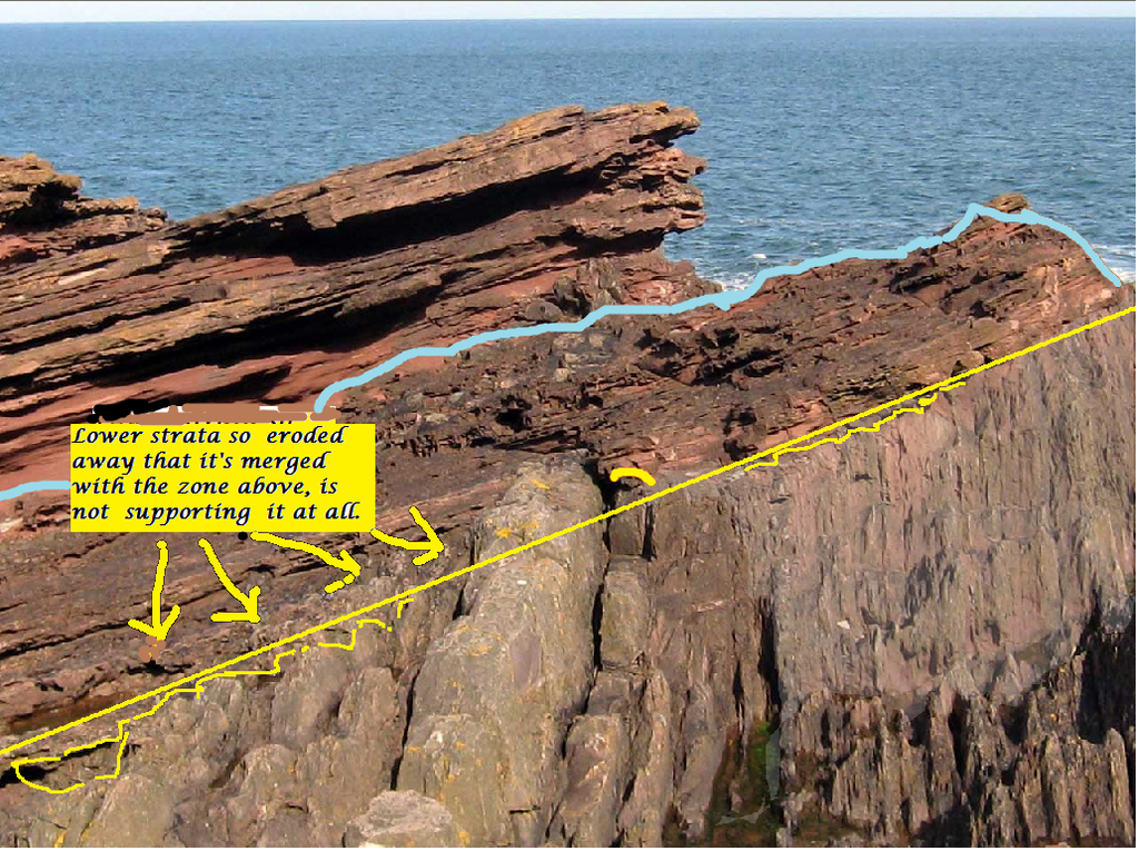
I realized there are eroded stumps of the strata of the lower section that should be highlighted too so I marked them on another version of the photo:
Edited by Faith, : No reason given. Edited by Faith, : No reason given.
|
|||||||||||||||||||||||
|
Faith Suspended Member (Idle past 1466 days) Posts: 35298 From: Nevada, USA Joined: |
The fact that you ask if I understand an unconformity the way you presented it in that diagram does give a possible direction to go in toward possibly understanding this endless experience of miscommunication.
Clearly, you and edge both think within Geological definitions. Let me explain what I do or think I do or try to do: I try to stick to what I think are simple ordinary descriptions of the physical phenomena I'm talking about. I am quite willing to use any geological terms that will better communicate what I'm trying to say,but some geological terms are so intimately bound up in Old Earth interpretations that I reject, it would cause at least as much if not more communication confusion if I used them while at the same time trying to explain my different interpretation. I think this may be at least some part of the problem but I'm not sure. I do, though, try to find simple descriptive words for what I'm talking about, that I assume anyone could understand. When I use the word "strain" I mean it the way it is used in normal nontechnical English. When I talked about rocks that are "naturally" flat -- as opposed to lumpy rocks like schist and folded strata -- such as the Kaibab plateau and the tops of buttes, it would never have occurred to me that could be misunderstood. Now, obviously this isn't working. Edge seems to completely misunderstand or not even be able to read at all, some descriptions I think are nothing but simple English. I'll even go back to a post that to him makes no sense and to me it's perfectly clear and it seems to me he just couldn't have read it because it's all there. Then of course when I do describe my own alternative view of what happened he just dismisses it completely. So, if this sort of thing accounts for the miscommunications maybe it can be the basis for sorting some of it out. Or maybe it's just hopeless and this says why. Edited by Faith, : No reason given. Edited by Faith, : No reason given.
|
|||||||||||||||||||||||
|
Faith Suspended Member (Idle past 1466 days) Posts: 35298 From: Nevada, USA Joined: |
That's beautiful. Now find us one that has a level flat surface. And hard as schist too.
Edited by Faith, : No reason given.
|
|||||||||||||||||||||||
|
Faith Suspended Member (Idle past 1466 days) Posts: 35298 From: Nevada, USA Joined: |
No, but it does have to be level if not totally tabletop flat and smooth. I go by the STRAIGHT lines shown in Message 213.
|
|||||||||||||||||||||||
|
|
Do Nothing Button
Copyright 2001-2023 by EvC Forum, All Rights Reserved
![]() ™ Version 4.2
™ Version 4.2
Innovative software from Qwixotic © 2024