|

Understanding through Discussion |
|
|
Register | Sign In |
|
QuickSearch
| Thread ▼ Details |
|
Suspended Member (Idle past 1465 days)  Posts: 35298 From: Nevada, USA Joined: |
|
Thread Info
|
|
|
| Author | Topic: The Geological Timescale is Fiction whose only reality is stacks of rock | |||||||||||||||||||||||||||||||||||||||||||
|
Admin Director  Posts: 13014 From: EvC Forum Joined: Member Rating: 1.9
|
After seeing the complaint Faith registered yesterday at Message 503 I read this thread forward from Message 547 to the end. I think the sense people have is correct, that despite many varied explanations Faith still doesn't understand geology's view of how a living landscape becomes part of the geological column. Dr Adequate's list of Faith excerpts in Message 601 makes clear how poorly it is understood how a landscape (such as the one I'm looking at now from my porch of trees and underbrush and dead leaves and birds and squirrels and chipmunks) becomes a minute part of a possibly miles thick layer of rock.
There's another point I've seen alluded to several times over the past 150 messages that I also think is important, that the fate of most terrestrial landscapes is obliteration through slow erosion, explaining why most layers in the geological column are marine. The soil in much of my state is just passing through on its way from the mountains to the sea. As long as the mountains exist then the net of incoming and outgoing soil is in balance and our landscape changes little across the centuries. But when the mountains are gone millions of years from now this chunky hilly landscape will disappear, worn down to a plain and possibly even disappearing beneath the waves. i'm still in a busy period, so my moderation efforts will be slight. I see Adminnemooseus has been looking in and keeping discussion on-topic. Please, no replies to this message.
|
|||||||||||||||||||||||||||||||||||||||||||
|
Admin Director Posts: 13014 From: EvC Forum Joined: Member Rating: 1.9 |
In Message 620 I think Faith may have provided some significant clues to where the problem lies:
Faith in Message 620 writes: I'm trying to talk about the UNIQUE situation of forming a landscape ON TOP OF A HUGE FLAT SLAB OF ROCK (which as the geo column was forming would have been the uppermost surface in the column, or the latest rock/time period representative to have formed.) But the more difficult problem is how that new landscape eventually becomes a new rock in the strata, as it must because that's the evidence in the geo column itself: one rock on top of another rock, with an assumed landscape "in between," meaning the landscape that grew on top of the former rock/time period and eventually became a rock on top of that rock/time period. This indicates three areas of misunderstanding:
Faith invariably pronounces my interpretations wrong, but even if they are I still think reaching a mutual understanding on these points would help advance the discussion. To Faith I would say that at this point people are not looking for a concession that they are right and you are wrong. It's just that no one, least of all modern geology, has suggested any of the ideas you are objecting to. If you think the actual ideas of geology are wrong then discussing the evidence and reasoning that led you to that conclusion should be very helpful. Please, no replies to this message.
|
|||||||||||||||||||||||||||||||||||||||||||
|
Admin Director Posts: 13014 From: EvC Forum Joined: Member Rating: 1.9 |
In Message 646 Faith takes a sincere stab at trying to understand what is being described. Edge and PaulK make attempts to answer, but their answers are very short and assume that Faith will be keeping their earlier explanations in mind and integrating them into her understanding, which I don't think is fair. The explanations must be repeated whole.
Faith appears to think that modern geology believes or at least requires these things:
This paragraph from Faith's Message 646 is enlightening. Though phrased as questions, she provides a good summary of what geology actually believes happens as sediments accumulate upon a landscape:
Faith in Message 646 writes: ABE: I guess I need to take more time trying to vconstruct the sequence here. Landscape is getting buried by sediments, habitat for many cratures going away. But we can assume that another landscape is growng up on top of it and they find a home there. This may take what, a few thousand years? More? Is this the same kind of landscape or ar3e things evolving already? Maybe we need a whole series of landscapes getting buried and new ones growing up? Maybe this goes on for a few million years and we are now in the next time period as assigned to the rocks. But the rest of the paragraph is very difficult to make sense of:
Now we've got the original time period/rock deeply buried with lots and lots of stuff on top of it. But that rock is one in a stack of rocks. Are all the time periods growing here at once? What about all that extra sediment to bury the landscape and turn it into rock? Doesn't that have to disappear so that what is actually seen in the strata is all that we see? Figuring out the thinking behind these questions is probably important. AbE: Please, no replies to this message (Jar replied before I added this - it contains some good explanations). Edited by Admin, : Fix point 4. Edited by Admin, : AbE.
|
|||||||||||||||||||||||||||||||||||||||||||
|
Admin Director Posts: 13014 From: EvC Forum Joined: Member Rating: 1.9 |
Faith writes: Percy keeps raising substantive issues and then saying I'm not allowed to respond to them. I've been raising issues that I've hoped would become the focus of discussion. I strongly encourage everyone to concentrate on these points. Please don't respond to me because I'm not a participant in the discussion, just a moderator.
By the way I can't look at your maps. My eyes can't handle glare these days and those are blinding. Too bad because I'd like to be able to see them. Screen brightness is adjustable. It can be diminished to view the images, then turned up again. Or you could try sunglasses. Please, no replies to this message.
|
|||||||||||||||||||||||||||||||||||||||||||
|
Admin Director Posts: 13014 From: EvC Forum Joined: Member Rating: 1.9 |
The replies to Faith still seem far too brief to be comprehensible by themselves.
Just mentioning one point this time, Faith still believes that sedimentary deposits that form life-bearing landscapes can only be deposited upon bare rock, not upon already life-bearing landscapes. (Message 694: "If you look at the strata, understanding that geology represents a time period with a landscape based on the contents of the rock for that time period, then you realize that the landscape has to sit ON the rock just as the rock for that landscape does.") I think Faith believes that geology thinks it happens like this:
One more point: Although it's been mentioned at least several times, I don't think it's been emphasized enough that the ancient landscapes Faith has in mind, the ones from her Message 333 and the ones being discussed, are unlikely to be long term depositional environments. The fate of most land, whether rock or sand or soil, is eventual obliteration through erosion. Here's a series of slides on The Sedimentary Context of Dinosaur Fossils that makes this point in passing. An excerpt:
quote: So when Faith mentions that her thinking derives from looking at the layers preserved in the walls of the Grand Canyon and trying to imagine how they formed, for most of those layers she should not be thinking of terrestrial landscapes but marine. Please, no replies to this message.
|
|||||||||||||||||||||||||||||||||||||||||||
|
Admin Director Posts: 13014 From: EvC Forum Joined: Member Rating: 1.9 |
A few suggestions:
|
|||||||||||||||||||||||||||||||||||||||||||
|
Admin Director Posts: 13014 From: EvC Forum Joined: Member Rating: 1.9 |
Some brief suggestions about where to focus discussion:
Also, please let's leave the snarky stuff out of the discussion. The goal shouldn't be to convince Faith that geology is correct but to inform her what geology actually says. Information presented while the recipient is of a skeptical mind is often simply lost. When enough of or the right kind of information has been communicated and accepted then previously presented but rejected information must be repeated. That is the nature of discussions on controversial topics. AbE: Please, no replies to this message. Edited by Admin, : AbE
|
|||||||||||||||||||||||||||||||||||||||||||
|
Admin Director Posts: 13014 From: EvC Forum Joined: Member Rating: 1.9 |
Despite Faith's comments in Message 778, I think Edge and Jar are pushing closer to making clear how a landscape like those we see today becomes part of the strata buried within the Earth.
In Edge's Message 776 I made his middle diagram of the Florissant more readable by providing it a white background. The non-horizontal sedimentary layers with curving interfaces in the former lake are worth noting.
|
|||||||||||||||||||||||||||||||||||||||||||
|
Admin Director Posts: 13014 From: EvC Forum Joined: Member Rating: 1.9 |
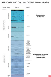
Some help interpreting this chart would be useful:
Is there a higher quality version of this chart? The text is very difficult to read. Here are my interpretations, please correct as necessary. Is it correct that the left side of the chart is just the geological periods, provided as a reference? And to the right of the geological periods are the stratigraphic details from different locations in western Illinois, namely around Colchester, around Warsaw/St. Louis (which are 140 miles apart), and around St. Clair/Moccasin Springs? (The layers at the very top of the diagram mention no location.) At each of these locations mentioned the geographic periods that have no layers are simply not represented at that location. Either layers deposited during those periods were later eroded away, or no layers were deposited for those periods, or some combination of deposition then erosion then deposition then erosion, etc., leaving behind what we see today. So at Colchester (the layers about a third of the way down the diagram) some Pennsylvanian layers are present, but nothing from before that. What is beneath those layers? Igneous base rock? In any case, this means that the interpretation of modern geology is that in the geologic periods before the Pennsylvanian that either nothing was deposited at this location, or whatever was deposited was later eroded away down to bedrock. Then during the Pennsylvanian the layers we currently see were deposited. There were once sedimentary layers above what we see now at Colchester, but those have been eroded away. What we know about them can only be implied from locations where those layers were not eroded away, or possibly by their sedimentary remains at some other location. And 30 miles west in Warsaw and over a hundred miles south in St. Louis there are no Pennsylvanian layers, but there are older Mississippian layers and beneath them even older Devonian layers. Possibly the layers seen at Colchester were deposited here too but were later eroded way. Alternatively there might have been no deposition in this location during the Pennsylvanian. There's not enough information in the diagram to tell. And around Moccasin Springs (200 miles south of Warsaw and 50 miles south of St. Louis) there are no Pennsylvanian, Mississippian or Devonian layers, but there are older Silurian layers and beneath those even older Ordovician layers. If there were ever Quarternary, Pennsylvanian, Mississippian or Devonian layers at this location, there is not enough information in the diagram to tell. Maybe layers were deposited during some or all of those time periods and later eroded away, maybe not. This diagram is even more difficult to read and needs a better version:
Edited by Admin, : Clarification.
|
|||||||||||||||||||||||||||||||||||||||||||
|
Admin Director Posts: 13014 From: EvC Forum Joined: Member Rating: 1.9 |
I think this would be a very helpful clarifiation. This is from Jar's Message 785:
jar in Message 785 writes: And in the following picture we are seeing sections from one location not from several different locations.
The gaps simply represent material that is missing and the intersections of those areas where there is material in reality fit together but with unconformities. Is that correct? Are we seeing that the layers in that column really are not flat and smooth and do show internal signs of erosion and deposition? This was my original interpretation, but then I became uncertain and wondered if the top of each of the four stratigraphic columns represents a modern topography at four different locations in western Illinois. They all slope downward toward the west, so perhaps that's because they're bounded on the west by the Mississippi River?
|
|||||||||||||||||||||||||||||||||||||||||||
|
Admin Director Posts: 13014 From: EvC Forum Joined: Member Rating: 1.9 |
edge writes: jar writes:
The could locally be flat,... Are we seeing that the layers in that column really are not flat and smooth and do show internal signs of erosion and deposition? Here's the diagram again:
The boundaries between adjacent stratigraphic layers that are not unconformity boundaries appear to be very flat and straight in the diagram, but I'm guessing that Jar was actually asking about the uncomformable boundaries between the stratigraphic groups. For example, the bottom of the next to last stratigraphic section includes the Wapsipinicon and Hsing ss formations (apologies for misspellings, the text is fuzzy), and they appear to be above a sloping and irregular unconformity.
...but as the thicknesses of the formations and little channel slots show, these are continental sediments. They do not persist across the continent. Is there a typo here, because this appears to say that they are and are not continental sediments.
|
|||||||||||||||||||||||||||||||||||||||||||
|
Admin Director Posts: 13014 From: EvC Forum Joined: Member Rating: 1.9 |
edge writes: This was my original interpretation, but then I became uncertain and wondered if the top of each of the four stratigraphic columns represents a modern topography at four different locations in western Illinois.
They represent the topography from west to east after erosion to those levels. They represent terrain, aka 'landscape' which is then buried by the next transgression. Here's the diagram again:
So, for example, the Wapsipinicon, Hsing ss and Cedar Valley formations at the bottom of one stratigraphic section actually lie directly on top of the bottommost stratigraphic section at an unconformity boundary.
They all slope downward toward the west, so perhaps that's because they're bounded on the west by the Mississippi River?
The Illinois Basin occurs to the east, so that is where the sediments are thicker, especially for the Tippecanoe sequence. Erosion occurred earlier at the edges of the basin. I don't understand the part about there being a basin to the east, since the slope of the unconformities is downward to the west.
|
|||||||||||||||||||||||||||||||||||||||||||
|
Admin Director Posts: 13014 From: EvC Forum Joined: Member Rating: 1.9 |
edge writes: As I mentioned, I guess this is way too technical. My intent was to show the presence of erosion in the geological record and the inundation of pre-existing landscape in a way that showed the strata and how they formed. My apologies for the confusion Please continue as you have. Let's get the information out there, and people like me can ask questions as necessary.
|
|||||||||||||||||||||||||||||||||||||||||||
|
Admin Director Posts: 13014 From: EvC Forum Joined: Member Rating: 1.9
|
jar writes: It's from World geologic provinces and the important part is the table below the image that has links to a short description of each type of structure. Reading the descriptions in relation to the image may help us understand the general trends that are going on in different areas simultaneously. We can see where general activity is happening, where nothing much is happening, where the general direction is up or down. Elaborating on this in a post might be helpful. Although Faith will deny it as soon as attention is called to it, she doesn't accept that the particles that make up sediments are eroded from higher regions and carried by wind, water and gravity to lower regions (see Message 789: "Why so consistently flat and straight as if there were some rule that erosion would have to totally obliterate a mountain range before anything could be deposited in its place."). So I think it might be helpful to describe how the light blue regions are orogens, high regions undergoing erosion that produces sediments that are eventually deposited in lower regions like the darker blue basin regions and orange shield regions.
|
|||||||||||||||||||||||||||||||||||||||||||
|
Admin Director Posts: 13014 From: EvC Forum Joined: Member Rating: 1.9 |
I suggest focusing on these areas:
That's enough for today. Please, no replies to this message.
|
|||||||||||||||||||||||||||||||||||||||||||
|
|
Do Nothing Button
Copyright 2001-2023 by EvC Forum, All Rights Reserved
![]() ™ Version 4.2
™ Version 4.2
Innovative software from Qwixotic © 2024