|

Understanding through Discussion |
|
|
Register | Sign In |
|
QuickSearch
| Thread ▼ Details |
|
Thread Info
|
|
|
| Author | Topic: The TRVE history of the Flood... | |||||||||||||||||||||||||||||||||||||||||||||||||||
|
edge Member (Idle past 1732 days)  Posts: 4696 From: Colorado, USA Joined: |
Since you recognize these imaginary unconformities so easily, please identify the six that are supposedly represented on the chart of the Cratonic Sequences and give their geographic location. Thank you.
Well, I am familiar with some of them having worked in the areas; and I have mentioned some to you already in different context. One is the Zuni sequence which ended with the formation of an unconformity on which dinosaurs walked and the coal fields of the eastern Rocky Mountains and the high plains. Another is your favorite, the Sauk Sequence which started with inundation of the unconformity at the base of the Tapeats Sandstone. This one is not called the 'Great Unconformity' for nothing. It is truly continental in scale. Another that I am familiar with is the Absarokan Sequence which started during the Pennsylvanian Period, in 'guess where.' Do you remember what I said about that? If you click on the links for each sequence located on the Wikipedia page that I posted earlier, you can go to a description of each sequence with more detail. I may try to do that again later when I have some time. Once again, I refer you to Coyote's questions. What you see here is personal experience with actual data and it is all being presented to you by Pressie, Coyote and myself. With what can you match that experience?
|
|||||||||||||||||||||||||||||||||||||||||||||||||||
|
edge Member (Idle past 1732 days) Posts: 4696 From: Colorado, USA Joined: |
Your posts are too cryptic for me to follow, and I think you should post the link again instead of asking me to go find it.
Okay, it's going to take more work than I thought. I had thought that there were direct links, but I've been to too many Wiki sites to remember properly Here is an example: Lets talk about the Tippecanoe Sequence, mid-Ordovician to early Devonian in age. Here is a quote from John Morris, of all people:
quote: So, the Tippecanoe Sequence, as described by Morris is bound at top and bottom by unconformities. The basal unit, overlying the lower boundary is the Saint Peter Sandstone. In that case, where ever we see the Saint Peter Sandstone, it should overlie an unconformity which is the lower bound to the Tippecanoe Sequence. Here is a diagram showing the Saint Peter Sandstone and equivalent sandstone formations across North America. http://www.icr.org/i/articles/af/st_peter_sandstone_wide.jpg So, if you want to find that unconformity, just go to any location within the brown-colored area on the map. Drill a borehole if necessary. You will find the unconformity. I'm not sure, but the basal Tippecanoe (St. Peter Sandstone) may correlate with parts of the Old Red Sandstone in northern Europe, attesting to the intercontinental status of the Tippecanoe Sequence. Now, do you really want me to do this for each sequence and each boundary in the chart that you presented? Edited by edge, : No reason given.
|
|||||||||||||||||||||||||||||||||||||||||||||||||||
|
edge Member (Idle past 1732 days) Posts: 4696 From: Colorado, USA Joined: |
OK, what do these unconformities look like? How would I recognize it?
You have been shown a number of unconformities, mostly denied by yourself. Some are only known by mapping large areas, others by age dates. I have already explained to you about erosional surfaces, paleosoils and trace fossils.
And tell me again what the significance of these unconformities is understood to be?
They represent missing geological record and are boundaries between major geological events.
Not if there is reason to think they all follow pretty much the same pattern Morris described.
Eventually they would. This one was relatively easy, however.
ABE: By the way, the link to the St Peter Sandstone article only goes to a tiny map of the US.
I believe there are two links in the post.
|
|||||||||||||||||||||||||||||||||||||||||||||||||||
|
edge Member (Idle past 1732 days) Posts: 4696 From: Colorado, USA Joined:
|
You mention Coyote's questions. I can't find them. Please keep in mind that sometimes I can't digest everything in your posts; probably often. Sometimes it's a big accomplishment to get any of it and the rest has to be ignored.
Well, like with so many disciplines, people spend years studying these things at university. I can't apologize for it being a complex science.
I'm used to Coyote mostly making remarks about radiometric timing and may not have read the post you are talking about in the first place. And I usually regret having any conversation at all with Pressie so I wouldn't get that reference either. You're hard enough to deal with hut there are others who are actually harder.
Well, Pressie is a bit impatient, but it wouldn't hurt to learn something from his posts. Coyote has a different approach being an archaeologist, but the tools and reasoning are very similar to geology. I understand both.
AND: I don't expect to match anybody's experience. If it's clearly articulated it can be very helpful to hear about it, but sometimes people are good workers in their field but not good with words. If I get a clear picture of what someone is talking about then it may raise questions that help organize my Flood point of view, not that such a result would please you of course.
The impression is that you are not learning anything; in fact it seems more that you refuse to learn anything. That is frustrating to people who have spent their careers studying a scientific profession. In fact, in many cases, it is insulting.
|
|||||||||||||||||||||||||||||||||||||||||||||||||||
|
edge Member (Idle past 1732 days) Posts: 4696 From: Colorado, USA Joined:
|
I was answered that subsidence of the land could be the explanation and I explored that possibility in a later post. But nobody gave any information about whether or not subsidence is considered to have occurred.
There were a couple of people who provided information about subsidence. We can elaborate on that all you want. However, there is another phenomenon going on. As I recall none of this was considered by the resident Geologists. I would still like to hear how they account for the necessary great depth of the water at the end of all those separate transgressions. As this diagram shows, sedimentary formations of the Phanerozoic can be very thick on the edges of the continents or basins, and thin toward the center of the continental landmass. So that the oceans do not have to be as deep as you seem to think they should be to stack a very thick package of sediments. As you go to the left, the formations become fewer and they become thinner; and in some cases can pinch out completely. Part of this effect is due to later erosion, but I think it's pretty clear that thicker sections are outbound from the continental core.
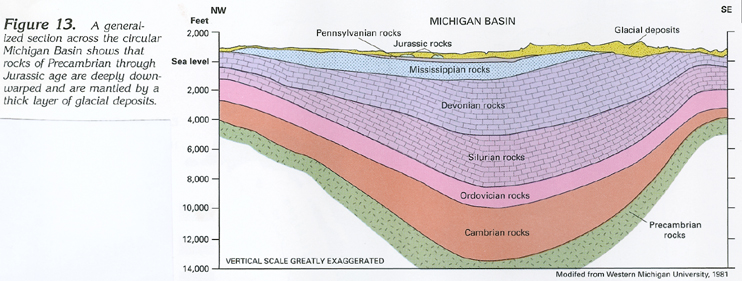
Here is a cross section of the Michigan Basin. I'm not sure how to get this situation without subsidence of the basin.
Sometimes the subsidence is accompanied by uplift along fault zones. Here is a cross section of the Paradox Basin where the ocean would be to the left and the basement rocks have been uplifted along a fault and shed coarse debris (conglomerate) into the basin on the right side and more fine grained sediments out into the sea.
Again, I don't see how to get this pattern without some kind of relative subsidence of the basin. Here is a schematic diagram of the moat around the Hawaiian Islands caused by loading of the oceanic crust. Note that as the asthenosphere is displaced, it flows outward to form a 'wave' beyond the moat.
This is evidence for crustal rocks subsiding into the asthenosphere to form basins that can accept thicker sequences of sediments. IIRC, Tertiary muds reach depths of almost 50,000 feet in the Gulf of Mexico (that we know of). Of course that includes some water, but it shows how thick sedimentary sections can grow.
|
|||||||||||||||||||||||||||||||||||||||||||||||||||
|
edge Member (Idle past 1732 days) Posts: 4696 From: Colorado, USA Joined: |
Basins have NOTHING to do with the layers of the Cratonic Sequences.
Another bombastic statement from you. The cross sections clearly show that the cratonic sequences are thicker and the formations more numerous in the basins (by which I am including the ocean basins).
|
|||||||||||||||||||||||||||||||||||||||||||||||||||
|
edge Member (Idle past 1732 days) Posts: 4696 From: Colorado, USA Joined: |
I think that if you and Edge discuss his Michigan Basin diagram it will help explain how sediment layers form that are far thicker than the depth of water: ...
The intent was to show two things. 1. Evidence for subsidence.2. Thinning of the cratonic sequence over the continental crust. The latter is another concept that I'd like to introduce because Faith has complained the the water has to get exceptionally deep in order to deposit the cratonic sequences on higher parts of the craton; and therefor must have been due to the flood. My point is that, no, it doesn't need to be all that deep. My last diagram was to show how the crust (continental or oceanic) can sink into the asthenosphere during subsidence. I didn't expect such a agressively disagreeable reaction.
|
|||||||||||||||||||||||||||||||||||||||||||||||||||
|
edge Member (Idle past 1732 days) Posts: 4696 From: Colorado, USA Joined:
|
"Thicker and more numerous in the basins?" I'm sorry but I can't begin to fathom what this has to do with the problem I'm posing.
Your assumptions are a case in point. What do basins have to do with layers deposited flat all the way across the continent? Clearly, the sediments are not uniform across the continent. These diagrams, based on oil exploration are pretty conclusive.
What do basins in which all layers were already formed ...
But they weren't already formed. The layers show the same transgressive sequence as the crattonic sequences.
... have to do with the problem of sea level rises required to cover each transgression's sedimentary deposits, ultimately to the point where it's had to rise as high as Noah's Flood would have?
They show that the layers thin and pinch out as higher levels of the craton are approached. Therefor sea level did not reach the deep-water proportions that you surmise.
That is, the known geological column is a few miles thick.
But they are not as thick over the craton. In fact, there is ample evidence that the sediments pinched out against an emergent land mass.
Whether it was laid down in "packages" by six separate transgressions of the sea, or one at a time, over hundreds of millions of years, the level of the sedimentary deposits would be rising with each deposition, so the water which deposited them also had to rise to cover it all.
Except for the simple fact that we know subsidence occurs. That is indisputable from the diagrams (and many more, if you want) that I presented. We also know that there is a mechanism for subsidence which includes loading by sediments.
And that means it had to rise just about as high as Noah's Flood. Which makes this whole scenario good evidenced for that event.
Except that there is not nearly the thickness on the craton, so the water was simply not that deep. And, in fact, there were shorelines preserved in those sediments which means that there was an emergent, actively eroding land mass.
If you are saying something about deposition without water, where in the column did that occur?
Well, for one it occurs in volcanic fields and sand ergs. But, wrt to the cratonic sequences they are irrelevant. I don't know where you came up with that.
|
|||||||||||||||||||||||||||||||||||||||||||||||||||
|
edge Member (Idle past 1732 days) Posts: 4696 From: Colorado, USA Joined: |
Why do you post such utterly stupid comments Faith. New layers are being deposited across the entire continent every single day.
In fact, without basin formation, the geological record would look very different and we wouldn't have an accurate understanding of sedimentation. Interestingly, prior to plate tectonic theory, the formation of huge, deep sedimentary basins was though to be an early phase of mountain building. It was the only explanation available. Maybe someone older than I (heh, heh ...) can remember those days.
|
|||||||||||||||||||||||||||||||||||||||||||||||||||
|
edge Member (Idle past 1732 days) Posts: 4696 From: Colorado, USA Joined:
|
What does "emergent" describe?: But actively eroding, yes, exactly what the Flood would have done as it receded.
The problem is that there was active erosion occurring throughout the deposition of all of the cratonic sequences. If you don't know what emergent means, I haven't the words to help you.
Your descriptions are not easy to follow but I haven't seen in anything you've said anything that changes what I've said.
Of course not. You are a YEC. And of course it's hard to follow. It's not as simple as YECs imagine.
The height of the craton is irrelevant, ...
In a way, this is correct. Mountain ranges are not necessarily considered part of the craton. However, it is clear that they existed and that the shed debris into the shallow cratonic seas.
... subsidence in local basins is irrelevant.
It is relevant to the degree that is shows how the sedimentary units vary across the continent. In other words, is shows how cratonic sequences vary in thickness. It shows the reasoning regarding 'shallow epeiric seas'.
For the transgressions to have laid down the enormous depth of the geological column that actually exists, the sea level would have to have approached that of Noah's Flood.
As I have pointed out repeatedly, the depth need not have been all that great. And more to the point, it need not have covered the higher parts of the continent composed of mountainous areas.
I argued all this in previous posts and I guess I'm going to have to go find them all. The unconformities would have been caused by the regression of each sequence, which would of course have been very rapid, not your slow millions of years affair, and the erosion probably removed a lot more than a layer or two.
Of course. The problem you have is that there are unconformities throughout the period of your flood.
Percy said you were talking about deposition of thick sediments without water, not I. So since you weren't, end of subject.
Almost certainly a misunderstanding on your part. I have reviewed the exchange and I see nothing to that effect.
I gave a much better reason for the pinching out, but leaving that aside for the moment, why should the height of the craton have anything to do with how much water it would have taken to lay down the entire geological column across the continent?
Ummm .... Because in a rising sea, it would take longer to cover higher areas?
The regressing water would have caused the "unconformities" as Morris described, by eroding them away, so would also have eroded sediments on the higher craton. It should simply have erased the upper layers, not pinched them out.
I never said that it did.
The thinning could have been the effect of deposition over the higher land, but could just as well be the effect of the sinking of the strata into the basin AFTER they were all laid down.
Well, exactly. The higher parts of the craton were not under water and receiving sediments for the same amount of time. The problem with your scenario is that each sedimentary unit is thicker in the basin, so it had to have been some effect that was present at the time of sedimentation, i.e. subsidence.
Since the image is of a basin and not flat deposition over the craton.
Don't know what you mean here. Of course the craton is on the side of the diagram.
But again, there is nothing in what you've said to change what I described. Presumably the transgressions laid down the entire geological column to a depth of miles, ...
But not everywhere.
... because that is seen in many places, especially of course in the Grand Canyon, and that requires the rising of the sea level as I described. The presence of the craton has nothing to do with that.
You realize that the GC sequence is part of a basin, do you not? Many of the formations do not exist across the continent, and if they do they thin to the east.
|
|||||||||||||||||||||||||||||||||||||||||||||||||||
|
edge Member (Idle past 1732 days) Posts: 4696 From: Colorado, USA Joined: |
The reason they look flat today is because of the geological process of compaction. The environments that they represent (not are), could have been very different when they were on the surface and they were not necessarily flat when they were being laid down.
Over short distances, the contacts can look quite 'flat'. However, in detail they are not flat and regionally they can thicken and thin and even disappear entirely. Layers get a lot flatter over time as they build up, and it takes time. For instance, in the Grand Canyon area, the Coconino sandstone varies from about 60 feet to over 600 and back to 60 going from east to west across the GC area. This can hardly be called 'flat'. There is no equivalent formation in Kansas, so we cannot consider it to be continental in scale. And yet, we see Faith say the same thing over and over again, that these sedimentary units are 'flat' with parallel top and bottom, and are continentally extensive. The point is that these deposits are quite thick at the margins of the cratons or in the interior basins, and thin across the craton if they even exist there.
|
|||||||||||||||||||||||||||||||||||||||||||||||||||
|
edge Member (Idle past 1732 days) Posts: 4696 From: Colorado, USA Joined: |
4000 feet vertically is about the same as 40 miles horizontally (4000 feet vertically, ~200,000 feet horizontally). A vertical exaggeration of about x50 (if I did the math correctly). Without the vertical exaggeration the diagram would look something like: In which you can't see anything, which is why vertical exaggeration is used. The strata are, in reality, still close to horizontal. Moose Heh,heh ... Yes. The layers appear to be 'flat', even perhaps, in the sense that Faith writes. However, the point is that the cumulative layers are thicker in the center of the basin and some of them do not exist at the margins. So, if you were budgeting to drill an oil field in the Ordovician, you'd better plan accordingly. Vertical exaggeration accentuates this observation. But it does have its disadvantages too. Edited by Adminnemooseus, : {Note - ... - Adminnemooseus} Edited by edge, : No reason given. Edited by Adminnemooseus, : Edge fixed his error, which eliminated the need for my previous edit material, which I have now removed.
|
|||||||||||||||||||||||||||||||||||||||||||||||||||
|
edge Member (Idle past 1732 days) Posts: 4696 From: Colorado, USA Joined: |
I've read up through Faith's Message 615, and I think the most important part of your explanation that still hasn't gotten across is how a shallow sea can leave behind miles-thick sedimentary deposits. Once this point is clear then sedimentary deposits across the craton can be explained.
Well, the first point is that the sedimentary rocks are not as thick on th higher parts of th craton. In fact, some of the formations were never deposited because the seas never rose high enough to cover the craton or the mountain belts built on continental crust. The thickest sections are on the craton margins or in intracratonic basins. This includes the Grand Canyon area. The second point is that both continental and oceanic crust will subside due to loading by sediment and other tectonic factors. This means that sediment can continue to stack up without increasing the water depth. Hope this helps.
|
|||||||||||||||||||||||||||||||||||||||||||||||||||
|
edge Member (Idle past 1732 days) Posts: 4696 From: Colorado, USA Joined: |
The last time you pressed a heavy hot iron on a wrinkled shirt, did it stay wrinkled?
I got nice flat wrinkles. 
|
|||||||||||||||||||||||||||||||||||||||||||||||||||
|
edge Member (Idle past 1732 days) Posts: 4696 From: Colorado, USA Joined:
|
After all, as the evo side frequently protests, the Ordovician is a time period not a bunch of rocks (OSLT).
Okay, to clarify (and I'm not much of a stickler on things like this) the official terminology as I learned it is this, from Wikipedia:
That said, I do recognize that in geo-talk (slang?), "drilling an oil field in the Ordovician" actually means "drilling an oil field contained in Ordovician aged rocks". "A geologic period is one of several subdivisions of geologic time enabling cross-referencing of rocks and geologic events from place to place. These periods form elements of a hierarchy of divisions into which geologists have split the Earth's history. Eons and eras are larger subdivisions than periods while periods themselves may be divided into epochs and ages. The rocks formed during a period belong to a stratigraphic unit called a system." (Period - Wikipedia(geology)) (bold added for emphasis) In other words Ordovician Period (notice capitalization) refers to a period of time, and Ordovician System refers to the rocks that formed during that time period.
Maybe tomorrow, when it gets light, I'll go out and look at some preCambrian.
Okay, so the Precambrian is another time period that includes time before the Cambrian Period. It is huge, consisting of 90% of the existence of the planet. As we learn more about this deepest part of time, it becomes increasingly complex and is more and more subdivided. But yes, in your area, most of the rocks are Precambrian in age. Edited by edge, : No reason given. Edited by edge, : No reason given.
|
|||||||||||||||||||||||||||||||||||||||||||||||||||
|
|
Do Nothing Button
Copyright 2001-2023 by EvC Forum, All Rights Reserved
![]() ™ Version 4.2
™ Version 4.2
Innovative software from Qwixotic © 2024