|

Understanding through Discussion |
|
|
Register | Sign In |
|
QuickSearch
| EvC Forum active members: 64 (9164 total) |
|
| |
| ChatGPT | |
| Total: 916,784 Year: 4,041/9,624 Month: 912/974 Week: 239/286 Day: 0/46 Hour: 0/0 |
| Thread ▼ Details |
|
Suspended Member (Idle past 1470 days)  Posts: 35298 From: Nevada, USA Joined: |
|
Thread Info
|
|
|
| Author | Topic: Motley Flood Thread (formerly Historical Science Mystification of Public) | |||||||||||||||||||||||||||||||||||||||
|
caffeine Member (Idle past 1050 days)  Posts: 1800 From: Prague, Czech Republic Joined: |
Hi Faith,
I'm having a lot of trouble understanding you here. You say
What I'm saying is that the strata in all the columns everywhere, even the most incomplete ones as far as the time scale goes, are always found in blocks of originally horizontal strata, eroded as blocks, deformed as blocks, except for the angular unconformities which put two blocks at different angles to each other. So, there is no sign of strata being deformed by tectonic movement, and then new strata laid on top, except where there are signs of strata being deformed by tectonic movement, and then new strata laid on top. I guess that's true, but surely it demonstrates that you're wrong. Angular unconformities exist; so there is evidence of new sedimentary layers forming after older ones have moved about. The model is falsified. Now, I'm wondering if your thinking is being muddled by being wedded to the idea that signs of tectonic movement all represent one catastrophic event - since you talk about some formations in England not being disturbed by the breakup of Pangaea. But the idea that all tectonic activity is the result of one big catastrophic event is a requirement of your model, not anyone else's. There's no reason to assume this, and it seems unreasonable on the face, since we know tectonic activity is ongoing today. I'm aware you think this all started post-Flood, but that's something that needs to be established. Incidentally, you mention that England's rocks go all the way back to the Cambrian, and so represent the full geological column. There are rocks much older than the Cambrian, however. The Cambrian is estimated to have been about 540-485 million years ago, while the Earth is believed to be about 4,500 million years old. Britain probably lies on rocks dating back about 3,000 million years, but they are not exposed anywhere in England.
That the strata were all laid down one on top of another without being eroded or deformed until they were all laid down. That suggests there were no time gaps between layers. abe: I mean VISIBLE time gaps, spaces where erosion should have occurred and didnt'; I'm not talking about the supposed missing layers or unconformities. /abe This is a very strange condition. You're not accepting unconformities as evidence of time gaps. I do understand that in your 'model' there are no big time gaps; but what would a visible time gap actually be? Assuming, for a minute, that the standard old earth model is correct; in what way would you expect missing layers to be visibly different? I have no idea what "spaces where erosion should have occurred and didn't" is supposed to mean. Edited by caffeine, : sentences that stop halfway through - I should learn to reread before posting.
|
|||||||||||||||||||||||||||||||||||||||
|
Percy Member  Posts: 22492 From: New Hampshire Joined: Member Rating: 4.9 |
edge writes: Okay, the Colorado Plateau has some mountain ranges in it but much of it is a large, 'flat' surface of relatively low relief. As you drive down the south edge, the Mogollon Rim, you get into a very mountainous and irregular terrain. Why is that so? Simple: it's erosion of the plateau at its edges. What do you think will happen to the region in the next 60 million years? My contention is that it will become more and more irregular as rivers cut more deeply into the plateau. When first considering this I figured that erosion at the plateau edges was just a form of incision and recession. I thought the plateau edges would gradually recede north, expanding whatever plateau is south of the Colorado Plateau. But after a little thinking I realized that you're probably saying that the Mogollon Rim is an example of an orogeny that requires erosion for exposure. Sounds, weird, but do I have that right?
Think of it this way. If you didn't have erosion, you would just get flat highlands. You're killing me. Like Faith I know that certain things are true, like that the Rocky Mountains were thrust into the sky by an orogeny to stand high and gleaming above the surrounding landscape, but unlike Faith I can go to Wikipedia and disabuse myself of misconceptions like this. After reading the geology section of the Wikipedia article on the Rocky Mountains I'm just confused. First it says the southern Rocky Mountains were thrust up through overlying Pennsylvanian and Permian layers, then it says the Rockies were once a high plateau like Tibet and that erosion gradually exposed the mountain range. How does unevenly thrust up underground rock cause a flat plateau at the surface? Is it that the orogeny is slow, and so any high spots created at the surface are worked on by the forced of erosion, thereby maintaining a flat surface? Something else? Checking the Himalayas, I see they formed pretty much the way I thought, colliding plates thrusting up mountains, but you have destroyed my illusions about the Rocky Mountains. I was fond of them.
What if there were no erosion of the modern Front Range in Colorado after its most recent uplift? Geez, just as I'm getting familiar with Arizona you change states on me! 
There would be no Pikes Peak, no Mt. Evans, etc. Just a big wall of rock. But aren't Mount Evans and Pikes Peak unique as mountains, unassociated with any orogeny? Even if we had draped a giant canvas over the Pikes Peak area to protect it from erosion during uplift and after, wouldn't it still tower over the nearby landscape, just covered with the less resistant rock that used to be there? --Percy
|
|||||||||||||||||||||||||||||||||||||||
Faith  Suspended Member (Idle past 1470 days) Posts: 35298 From: Nevada, USA Joined: |
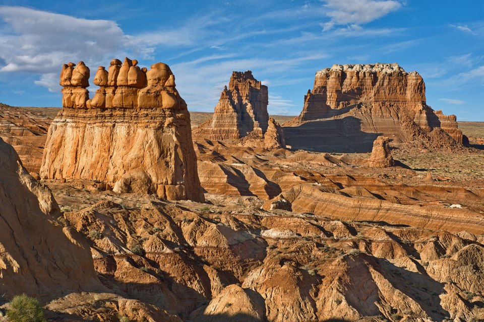
Hi Faith, I'm having a lot of trouble understanding you here. You say What I'm saying is that the strata in all the columns everywhere, even the most incomplete ones as far as the time scale goes, are always found in blocks of originally horizontal strata, eroded as blocks, deformed as blocks, except for the angular unconformities which put two blocks at different angles to each other. So, there is no sign of strata being deformed by tectonic movement, and then new strata laid on top, except where there are signs of strata being deformed by tectonic movement, and then new strata laid on top. I guess that's true, but surely it demonstrates that you're wrong. Angular unconformities exist; so there is evidence of new sedimentary layers forming after older ones have moved about. The model is falsified. Part of the point I'm making is that there should be lots of examples of erosion or deformation within the block or whole column of strata other than the angular unconformities, if the standard Time Scale understanding is true, but there aren't. Odd that there's only that one kind of example anywhere. That's the first point. The second point is that I don't believe the standard explanation of angular unconformities as "evidence of new sedimentary layers forming after older ones have moved about," I've got my own, that everybody here says is impossible but of course I disagree. I'd like to stick for now to the odd fact that there is NO sign of erosion or deformation until all the strata are laid down other than the angular unconformities. That is difficult enough to prove, maybe even impossible to prove for the many truncated columns/ time scales, though I've made some inroads there with cross sections in my opinion, but anyway this is why I point to the two examples where it is obviously true: The Grand Canyon-Grand Staircase area where the whole range of time periods is represented from Precambrian to Recent, except for the Silurian, the strata all laid down without any real sign of erosion or tectonic deformation until they were all in place, at which time we get the major erosion that carved both the canyon and the staircase. Here's the usual cross section where I first noticed this fact:
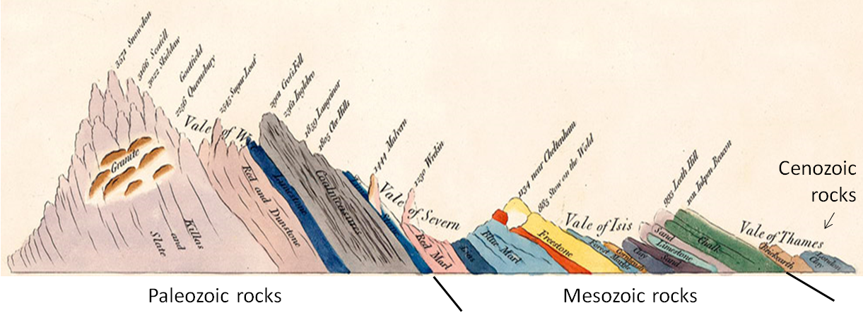
And the other is the William Smirh cross section of England which also shows all the time periods in one continuous stack, after which they are all tilted as a block:
Now, I'm wondering if your thinking is being muddled by being wedded to the idea that signs of tectonic movement all represent one catastrophic event - since you talk about some formations in England not being disturbed by the breakup of Pangaea. But the idea that all tectonic activity is the result of one big catastrophic event is a requirement of your model, not anyone else's. It's not even a requirement of mine, it's the conclusion I came to fairly recently after pondering the order of events as I've been seeing it on these various cross sections. And the point about the cross section of England is that it alone demonstrates that the standard timing of the splitting of the continents can't be correct because there is no disturbance in the laying down of the strata at the Jurassic period, it just continues up through Recent time without a hitch, and THEN they all are suddenly deformed into their tilted form. So that's one EVIDENCE for the timing of the splitting of the continents after all the strata were laid down. As is the erosion of the Grand Staircase-Grand Canyon area after all the strata were laid down.
There's no reason to assume this, and it seems unreasonable on the face, since we know tectonic activity is ongoing today. I'm aware you think this all started post-Flood, but that's something that needs to be established. I don't ASSUME it at all, as I say it's my own conclusion from the evidence as I've been encountering it. Yes there's lots of tectonic activity and erosion and volcanic activity, all of it, going on today, going on SINCE that one major catastrophic breaking apart of the continents and deformation of strata everywhere, as I've come to see it. I didn't see it this way a few years ago, it's a fairly new conclusion for me. Of course it has to be established, it's still a new hypothesis, but the evidence I'm giving here does support it.
Incidentally, you mention that England's rocks go all the way back to the Cambrian, and so represent the full geological column. There are rocks much older than the Cambrian, however. Actually I'm aware of that, and the Precambrian rocks are in fact shown on Smith's cross section to the far left too, but I sometimes try to make the point based only on the Phanerozoic strata where erosion or deformation should be demonstrated during their laying down according to the standard view, so I leave out the Precambrian rocks. Perhaps I should always include them.
The Cambrian is estimated to have been about 540-485 million years ago, while the Earth is believed to be about 4,500 million years old. Britain probably lies on rocks dating back about 3,000 million years, but they are not exposed anywhere in England. Timing issues aside, Precambrian rocks are shown on Smith's cross section. abe: Not marked as Precambrian, but the rocks are identified as Granite, which is a Precambrian rock and not part of the Paleozoic strata. /'abe
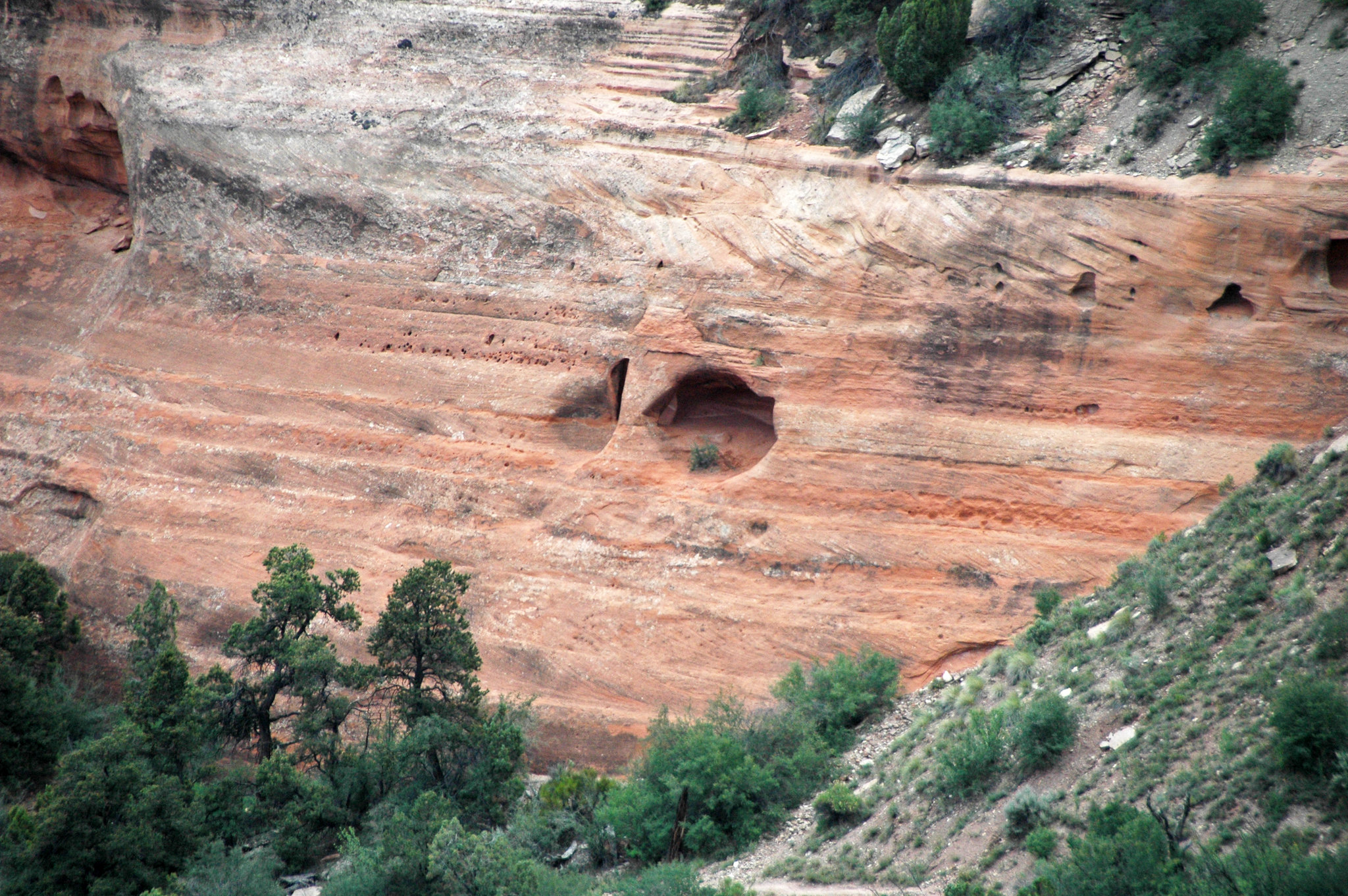
caffeine writes: Faith writes: That the strata were all laid down one on top of another without being eroded or deformed until they were all laid down. That suggests there were no time gaps between layers. abe: I mean VISIBLE time gaps, spaces where erosion should have occurred and didnt'; I'm not talking about the supposed missing layers or unconformities. /abe This is a very strange condition. You're not accepting unconformities as evidence of time gaps. I do understand that in your 'model' there are no big time gaps; but what would a visible time gap actually be? I'd expect to see visible erosion between layers, in the contact lines, and in fact very irregular contacts to the point of gullies and dips that cut into lower strata to some depth, all kinds of deformation and erosion that simply is not there. Here and there are bits of visible erosion, but the great majority of the strata in the Grand Canyon area are straight and flat with sharp contact lines. That is not what I'd expect of time periods of millions of years, which should have undergone all kinds of disturbances if that were true. But the disturbances clearly all happened after the whole stack was laid down and not while it was being laid down.
Assuming, for a minute, that the standard old earth model is correct; in what way would you expect missing layers to be visibly different? I have no idea what "spaces where erosion should have occurred and didn't" is supposed to mean. I hope what I just described may make it clearer what I mean. Thanks for asking these questions. Edited by Faith, : No reason given. Edited by Faith, : No reason given. Edited by Faith, : No reason given.
|
|||||||||||||||||||||||||||||||||||||||
|
Percy Member Posts: 22492 From: New Hampshire Joined: Member Rating: 4.9 |
edge writes: In geometry, braids conform more nearly to the course of the stream. They are nearly parallel. My misimpression developing from looking at images taken from the canyon rims, but looking at this from above it becomes obvious that the "islands" are definitely not parallel with the Colorado:
There can be braided geometries within the dendritic pattern, but mainly braided streams indicate high sediment loads that overload the stream. Water must continually find routes through and around the sediments that it is trying to move. Ah, yes, of course, seems so obvious now.
In a sense. However, for Faith to say that the stream was 18 miles wide and then decreased in width as the water source depleted is ridiculous. The width of the canyon is dictated by its ease of bank erosion. In the case of the GC, there are enough weak layers that the average slope is not steep even though there are precipitous cliffs. There a numerous canyons on earth that are very deep but not so wide because the rocks are more competent. Right, we're all trying to explain the width of the canyon at its widest point, and the explanation has to include why the canyon is so wide here and not at other places. Faith's explanation is that the river was at one time 18 miles wide at this widest point, but of course rivers flow fast in narrow portions and slowly in wide portions. To have the deepest erosion at the widest point where the river was most quiet is impossible. But why so wide here and not elsewhere? Why is the Grand Canyon so much wider than Marble Canyon or the western reaches of the canyon? If the amount of slope retreat is a function of time, then that suggests that the widest part of the canyon is also the oldest, but somehow I think that isn't true. The section on geology in the Wikipedia article on the Grand Canyon is frustrating because it contradicts itself. First it says this:
quote: So the Grand Canyon was a mile deep by 20 Ma. But then later it says this:
quote: This seems to say that erosion of the Grand Canyon began 5.3 Ma and reached its current depth of a mile by 1.2 Ma. I don't know that I believe either one. Any opinions? --Percy
|
|||||||||||||||||||||||||||||||||||||||
|
Percy Member Posts: 22492 From: New Hampshire Joined: Member Rating: 4.9 |
Faith writes: You can fault me for not being clear I am always talking about the geological time scale when I talk about the geological column/stratigraphic column, but no, I do not change my story. Sure you do, all the time. Most recently you keep changing back and forth between whether the top layers were loose sediments or not. But you continue to ignore my advice to quote what you're replying to so that you have it in front of you and do not misspeak, as you do here once again. There was nothing in the post you're replying to about you changing your story. My post was about you repeatedly asking whether the top erosion resistant layer of the Coconino Plateau is really Kaibab Limestone. In case you forgot again, yes, it is really Kaibab Limestone. This isn't the only area where your memory's a problem. You can't remember the posts about meanders. You keep introducing issues as if for the first time even though they've been discussed many, many times here.
The GC/GS and the map of England... Can you post this map again, or link to the post where it appears?
...show exactly what I'm talking about, all the time periods attached to their respective slabs of rock in place from Cambrian to Holocene,... Obviously unsatisfied with being wrong about something just once, you insist on being wrong about it over and over again. There is no stratigraphic column in England (or probably anywhere in the world) completely representing the geologic timescale from the Cambrian to the Holocene.
...after which all the erosion occurred and not before, after which all the tectonic disturbance occurred and not before. I don't think you really meant to say this. You just said that all the erosion and tectonic disturbances occurred after the Holocene, and since the Holocene is the current epoch, after the Holocene is the future starting now.
That is evidence... Bald declarations are not evidence. How do you not get this?
...that the geo column has come to an end,... The geologic timescale has no more come to an end than the Holocene has come to an end. Sediments continue to be deposited atop stratigraphic columns, growing those stratigraphic columns and continuing the geologic timescale on into the future. Time would have to stop for you to be correct.
...it is evidence of rapid deposition... Bald declarations about erosion and tectonics are not evidence. You have no evidence of rapid deposition, which is impossible anyway given the fineness of many sediments.
...and against the millions of years time scale. Again, you mentioned not a scrap of evidence against the geologic timescale.
The erosion marks the end, the tectonic disturbance marks the end. The erosion and tectonics that began after the Holocene in the future mark the end of what?
That did not occur during the laying down, it occurred after it was all laid down. Congratulations - another evidence-free post. --Percy
|
|||||||||||||||||||||||||||||||||||||||
|
edge Member (Idle past 1732 days)  Posts: 4696 From: Colorado, USA Joined: |
You said the layers in the hill are limestone and volcanic ash.
Yes, same question. Why couldn't they just as soon be limestone and volcanic ash?
|
|||||||||||||||||||||||||||||||||||||||
|
Percy Member Posts: 22492 From: New Hampshire Joined: Member Rating: 4.9 |
Faith writes: edge writes: LOOK AT THE STRATA IN THAT PICTURE. JUST LOOK,. NO LAKE BED, NO SALT FLAT, NO FIELD, NO BEACH, IS THAT FLAT. JUST LOOK. However, they are lake bottoms And they are flat. And why couldn't they be muds rather than salt? In fact, many are. You said the layers in the hill are limestone and volcanic ash. You're getting your conversations with Modulous and Edge mixed up. Since Edge mentions salt he's obviously commenting about salt flats, not formations in the Painted Desert. But even if you leave off his last sentence and assume he's talking about the Painted Desert, what he said still makes perfect sense. If that were the context then the meaning is that the layers in the Painted Desert formations are lake bottoms that accumulated sediments of limestone and volcanic ash, both very common layers of the Chinle Formation out of which the Painted Desert formations eroded. --Percy
|
|||||||||||||||||||||||||||||||||||||||
|
edge Member (Idle past 1732 days) Posts: 4696 From: Colorado, USA Joined: |
When first considering this I figured that erosion at the plateau edges was just a form of incision and recession. I thought the plateau edges would gradually recede north, expanding whatever plateau is south of the Colorado Plateau. But after a little thinking I realized that you're probably saying that the Mogollon Rim is an example of an orogeny that requires erosion for exposure. Sounds, weird, but do I have that right?
An interesting way of putting it, but yes.
You're killing me. Like Faith I know that certain things are true, like that the Rocky Mountains were thrust into the sky by an orogeny to stand high and gleaming above the surrounding landscape, but unlike Faith I can go to Wikipedia and disabuse myself of misconceptions like this. After reading the geology section of the Wikipedia article on the Rocky Mountains I'm just confused. First it says the southern Rocky Mountains were thrust up through overlying Pennsylvanian and Permian layers, then it says the Rockies were once a high plateau like Tibet and that erosion gradually exposed the mountain range. How does unevenly thrust up underground rock cause a flat plateau at the surface?
By being eroded to the local base level. Below base level erosion can't occur (except possibly by glaciers), so you end up with a 'peneplain'.
Is it that the orogeny is slow, and so any high spots created at the surface are worked on by the forced of erosion, thereby maintaining a flat surface? Something else?
Sure, think of it as competition between erosion and uplift. High relief means rapid erosion (generalizing here) and low relief means slow erosion.
Checking the Himalayas, I see they formed pretty much the way I thought, colliding plates thrusting up mountains, but you have destroyed my illusions about the Rocky Mountains. I was fond of them.
Well, the are much more attractive having been eroded.
Geez, just as I'm getting familiar with Arizona you change states on me!
Well, then it's time to move on to the Roraima Plateau. This area is very high plateau rising out of the Amazon-Orinoco jungle as the 'Grand Sabana'. It's very close to flat and it collects a huge amount of water that drains off the edges in places like Angel Falls. At the edges of the plateau, erosion has created very narrow, spire-like mesas called tepuis wich inspired the novel 'Lost World'. There are no 'mountains' as we think of them, just a giant high plateau with outliers.
But aren't Mount Evans and Pikes Peak unique as mountains, unassociated with any orogeny?
Well, they are discrete mountains now. But at one time they were planed off to maybe near sea level and then rose again. In fact, there is speculation that such a peneplain is the reason that so many peaks reach an elevation of 14,000+ feet elevation but none at 15,000'. The peneplain has simply been uplifted and then dissected by streams and glaciers. In fact, if you look at the top of Longs Peak, it's kinda flat. Check out some pictures on line.
Even if we had draped a giant canvas over the Pikes Peak area to protect it from erosion during uplift and after, wouldn't it still tower over the nearby landscape, just covered with the less resistant rock that used to be there?
Not sure, but you still have all of the other Fourteeners to contend with. Why do the only reach that elevation? And actually, most of the erosion is probably due to rock structure: faults and fractures controlling erosion more than rock type. Please remember that I did say this is a bit philosophical. One could simply argue that since erosion occurs along with uplift, that mountains form immediately, and I'm full of baloney. But I'm still saying that erosion is a huge part of the deal in forming mountains.
|
|||||||||||||||||||||||||||||||||||||||
|
edge Member (Idle past 1732 days) Posts: 4696 From: Colorado, USA Joined: |
Right, we're all trying to explain the width of the canyon at its widest point, and the explanation has to include why the canyon is so wide here and not at other places. Faith's explanation is that the river was at one time 18 miles wide at this widest point, but of course rivers flow fast in narrow portions and slowly in wide portions. To have the deepest erosion at the widest point where the river was most quiet is impossible.
Well, it's fairly simple. Since the GC rocks are not (in the upper levels) composed of strong rocks they have to attain an angle of repose above the river level. So, the deeper the canyon the wider the canyon. But why so wide here and not elsewhere? Why is the Grand Canyon so much wider than Marble Canyon or the western reaches of the canyon? More later.
|
|||||||||||||||||||||||||||||||||||||||
|
Percy Member Posts: 22492 From: New Hampshire Joined: Member Rating: 4.9
|
Hi Moose,
I got the general idea of the point you were making but wasn't able to follow the chain of logic. I mean that I think I understood the technical points, but not how they fit together into an argument. Here's my attempt at putting the pieces together: You first explain that the particular qualities of the garnets at the top of the Vishnu Schist required an overburden of about 6 miles in order to form. Then you quote Faith insisting that there were only three miles above the schist. You rebut this position by saying that there cannot be high grade metamorphic rock on one side of a contact and low grade metamorphic or unmetamorphosed rock on the other side unless that contact is a nonconformity or a fault. In context that would seem to be a reference to the Vishnu Schist//Tapeats contact, and your rebuttal then becomes an argument that this contact really is a nonconformity, and that deposition of the Tapeats must have taken place after the Vishnu Schist had already metamorphosed and cooled, else the Tapeats would itself have been metamorphosed though lower grade. So whether right or wrong that should help you understand how I read your post. Please correct as necessary, because I think it would be a helpful point for Faith to understand. --Percy
|
|||||||||||||||||||||||||||||||||||||||
|
Percy Member Posts: 22492 From: New Hampshire Joined: Member Rating: 4.9 |
Faith writes: They are so flat you can travel 400 mph in a land vehicle across them. Visible ups and downs over a few yards would make this impossible.
OK, conceded. So any ups and downs would occur over greater distances. You're conceding the very obvious.
Is the stratigraphy considerably flatter than this? Do you have measurements? Yes it is considerably flatter, you can see it with your eyes. You've been honest about how poor your eyesight is, so we know any claims you make of being able to see something are false. No one else sees what you claim to see, and that's because it's not there. You're seeing what you wish was there but is only in your own mind. You couldn't see how flat the Bonneville Salt Flats are, and you obviously can't see how flat anything else is, either. You also have no measurements Much strata *is* pretty flat, but not all. Here are some recent examples from this thread alone of how non-flat strata can be:
You are engaged in mystification through pontification here. Actually not. You are just doing the usual tit for tat that is so popular here without bothering to understand what I meant when I used those terms. This is false. What you said in Message 320 that Modulous was replying to was this:
Faith in Message 320 writes: Even salt flats aren't that flat, Mod, they have low and high points over distances (a few yards?) that would show up in such a contact line Mod called it pontification, but a more accurate characterization is that it is false and without merit.
But you tell me - what happens when you squash something? a) it gets flatter b) it gets less flat Depends on what's being squashed and what's doing the squashing. FlattER, but not necessarily really flat. Sand is only about 60% as dense as sandstone, so sandstone is only 60% as thick as the sand from which it formed.
What would be the effect of piling rock and earth onto something so it squashes it so much it becomes rock? a) it gets flatter b) it gets less flat c) no impact Depends on the distribution of weight. It could make depressions and lumps rather than flatness, highly compacted no doubt, quite hard, but not necessarily straight and flat, no. The question Mod posed and your answer are true Flood or not. The depositional environments we observe around the world today distribute sediments very evenly on lake and sea floors, which we know have large expanses of flatness that can be seen and measured. It would be much more likely in your chaotic Flood of waves and tides to get uneven deposition. That strata are as flat as they are says they formed from the same kind of depositional environments we see today. --Percy
|
|||||||||||||||||||||||||||||||||||||||
|
Faith Suspended Member (Idle past 1470 days) Posts: 35298 From: Nevada, USA Joined: |
Planned to get back to this eventually and now see Percy's addressed it so I'll give a brief response too.
There's something peculiarly attractive about the idea that you can measure the weight of a mountain by the chemical content of a garnet embedded in schist, but of course I have to wonder about how reliable it can be. That's one tiny little rock and six miles is one huge vague number to have been determined by that tiny little rock. I hope many garnets were used for the test and that they all contained precisely the exact same percentage of calcium, which is what shows the weight or pressure it took to form it, but is that the case? Measuring the percentage of calcium in a small gem can't be terribly precise, can it, and again that six miles height of mountain is far from precise.
|
|||||||||||||||||||||||||||||||||||||||
|
Faith Suspended Member (Idle past 1470 days) Posts: 35298 From: Nevada, USA Joined: |
The depositional environments we observe around the world today distribute sediments very evenly on lake and sea floors, which we know have large expanses of flatness that can be seen and measured. It would be much more likely in your chaotic Flood of waves and tides to get uneven deposition. That strata are as flat as they are says they formed from the same kind of depositional environments we see today. For "depositional environments" to be the basis of the strata requires that you ignore all the far more common environments that AREN'T flat and choose only those that are. That's a rather peculiar requirement it seems to me. For the marine strata of course you have water which does level sediments, only, really, truly, NOT as flat as those in that particular picture. But those in that picture are Triassic so we're talking land environment with dinosaurs, and those are definitely not naturally flat. So if you have hills and dunes and so on you have to get them flat first, right? Bring in a sea transgression, that would do it. That would also kill all the land life. Kinda counterproductive. And piling on a great depth of loose sediment for the necessary weight doesn't really suggest a flattening effect, hardening yes but flattening no; besides which then you have ti figure out what to do with that extra depth of sediment unless it just happens miraculously to be exactly what the geo column is made up of. If it isn't, you have to find a way to clean it off the flat slab of rock you think it formed. Beisdes which, the strata in th3e geo column are clearly separate from one another. How does your piled up sediment manage just to be a hardening agent without becoming part of the rock it's supposed to be hardening? And how are you getting the very different kinds of sediments that clearly distinguish one layer of rock in the geo column from another? Besides which the enormous extent of such strata as Tapeats sandstone and many others cannot be contained in any lake bed, and why aren't there any edges to them that look like lake beds either? The whole "depositional environment" idea is untenable. In any case the flatness shown in that Painted Desert hill is so much flatter than any salt sea or field or beach that you keep trying to palm off as the basis for it. Edited by Faith, : No reason given. Edited by Faith, : No reason given. Edited by Faith, : No reason given. Edited by Faith, : No reason given. Edited by Faith, : No reason given. Edited by Faith, : No reason given. Edited by Faith, : No reason given.
|
|||||||||||||||||||||||||||||||||||||||
|
Percy Member Posts: 22492 From: New Hampshire Joined: Member Rating: 4.9 |
Faith writes: Nothing about this shape suggests it is following fractures in the rock.
Can't imagine what you think would be suggested at this level two miles below the initial cracking of the uppermost strata. I'm going by your own words from Message 286:
Faith in Message 286 writes: The total lack of any alignment of the canyon with a tectonic fault line is evidence against this big crack model Faith is espousing. The concept came from this cross section
The canyon is cut into the south side of the rise shown clearly in the diagram, up and over the strata. The rise has been identified as the Kaibab uplift in many discussions here. The uplift obviously occurred according to the cross section, after all the strata were in place. Since there was another mile or two of strata above the current rim of the Grand Canyon, which is agreed to by standard geology, and evidenced by the Grand Staircase to the north and the butte to the south, the rise would have put strain on the uppermost strata high above the current rim. That's how the cracks developed in my scenario. Two miles above the current rim. And since this is going on just at the beginning of the draining of the Flood waters, it seems logical that the water, soon laden with chunks of strata, would have widened and deepened the cracks until they became a channel for the recedeing water that eventually became the Grand Canyon. So reading your above words we can see that you were claiming that fractures in strata two miles above the canyon deepened and eventually became the Grand Canyon. But nothing about the sinuous shape of canyon suggests following fractures in the rock, which tend to be straight.
And if the Kaibab Uplift caused these supposed fractures, how did water continue to flow through the uplifted area? The cracks deepened and widened as the water receded and they became a channel for it. By the time you get down to the level of the Kaibab they are pretty deep channels. But you've said the Kaibab Uplift began at the same time that the water started receding. The water was still four miles above the surface at that point in time, and the water level was dropping at only 1.5 inches/minutes, far too slow to create any flow of water four miles below the surface. By the time the water level dropped enough to be at the surface the Kaibab Uplift would have been a fait accompli. Water would have flowed down the sides of the uplift, to the east on the east side, to the west on the west side, and to the south on the south side where the Grand Canyon is. The North Rim is about a thousand feet higher than the South Rim. Where the Grand Canyon is today the water would have flowed south off the uplift, not east/west.
Why would these wet and malleable (your words) upper strata develop fractures? The uplift would have stretched them and put a lot of strain on them. But no fractures. And let's not forget that wet and malleable rock is your made-up idea anyway.
Why did none of these fractures propagate down to the Kaibab and below so they'd be included in the diagram? If the canyon was the result there would be no more fractures/cracks to demonstrate. If the canyon was the result of these fractures then that just reinforces what I said above, that the sinuous shape of the canyon is not in any way suggestive of following fracture lines. But directly addressing your argument, why would these fractures occur only where the canyon is and nowhere else on the uplift?
And didn't you finally decide the top strata were still loose sediments? I figure they couldn't have been very consolidated at the very top, yes. So loose sediments can't fracture, and wet and malleable rock can't fracture (you said it stretches just above). So where are these fractures coming from?
How would a thin sheet of water only a few inches thick and water levels lowering at a rate of an inch and half per minute be enough to carry chunks of strata? How big are chunks of strata anyway? You are confusing different stages of the flood as I've tried to describe it. The thin sheet of water running across the plateau that I picture being the cause of the meander doesn't occur until after the water and the strata two miles above that level have washed away,... Thin sheets of water running across a plateau do not create meanders, and water levels dropping at only 1.5 inches/minute are not going to create a significant flow of water anyway. Also, this contradicts your other claim above that fractures in the strata two miles above is what created the channel for the Grand Canyon.
...and that washing away would have had stages too,... Could you describe these stages?
...depending on how steep the exits were that opened up as the water level decreased. Some damming probably occurred in places and then broke and so on. Exits? Now you're imagining some kinds of natural dams were in place that needed breaking through? What is your evidence? Your story continues to be contradictory, contrary to the way water, sediments and rock behave, and completely lacking in evidence. --Percy
|
|||||||||||||||||||||||||||||||||||||||
|
Percy Member Posts: 22492 From: New Hampshire Joined: Member Rating: 4.9 |
Faith writes: If the etching of the Grand Canyon began in layers above the Claron, then why didn't the widening canyon drain all the water off the plateau and halt the erosion? I can't picture what you are talking about here. I'm sure it drained a lot of water off the surrounding areas, but not all of it. Water would have run off in many other directions than the canyon itself. Actually, you seem to have pictured it pretty well. With the canyon drawing in a great deal of water, why doesn't erosion of the Kaibab reflect this flow of water toward the canyon. An even better question is why there is any flow toward the canyon at all, since the water level is still a few inches above the top of the canyon? You don't seem to realize you have a significant problem - how do you get a significant flow of water in a channel that is completely submerged? Especially with the diminutive flow of water that could be driven by dropping water levels of only 1.5 inches/minute.
The water off the Grand Staircase took a lot of material off the cliffs and probably didn't get anywhere near the Grand Canyon. This is a strange thing to say. The Grand Canyon is part of the Grand Staircase. Were you trying to say something like the water at Bryce Canyon didn't get anywhere near the Grand Canyon? If so then I agree that would probably be true in your Flood scenario if we just go by the contour of the land shown in our favorite Grand Staircase diagram, but I was only referring to water on the Kaibab Uplift around the Grand Canyon.
You have to account for those extra miles of strata in your scenario too. We do. The plain was at one time much lower in elevation and filled with rivers and streams snaking back and forth across it that gradually eroded the upper layers away. This is something we see taking place around the world today. Can't decipher this at all I'm afraid. Are you talking about a plain two miles over the Grand Canyon area? Yes. That plain was at one time much lower in elevation and filled with rivers and streams migrating across it, gradually eroding the upper layers away. We see this happening at many places around the world today. --Percy
|
|||||||||||||||||||||||||||||||||||||||
|
|
Do Nothing Button
Copyright 2001-2023 by EvC Forum, All Rights Reserved
![]() ™ Version 4.2
™ Version 4.2
Innovative software from Qwixotic © 2024


 (1)
(1)