
|

Understanding through Discussion |
|
|
Register | Sign In |
|
QuickSearch
| EvC Forum active members: 65 (9164 total) |
|
| |
| ChatGPT | |
| Total: 916,913 Year: 4,170/9,624 Month: 1,041/974 Week: 368/286 Day: 11/13 Hour: 0/0 |
| Thread ▼ Details |
|
Member (Idle past 1374 days) 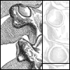 Posts: 9069 From: god's waiting room Joined: |
|
Thread Info
|
|
|
| Author | Topic: the googlemap UFOs | |||||||||||||||||||||||
|
Meeb Inactive Member |
Arachnophilia writes: doesn't look like damage to me. There is a possibillity that it could be a small dent on the lens. The huge zoom lens on the satellite would blur the dent when shooting long distance shots. If it is so, the changing shapes and locations could be light reflecting in diffrent angles from the dent.
|
|||||||||||||||||||||||
|
NosyNed Member  Posts: 9004 From: Canada Joined: |
But how could that end up on a grid or straight line?
|
|||||||||||||||||||||||
|
arachnophilia Member (Idle past 1374 days) Posts: 9069 From: god's waiting room Joined: |
There is a possibillity that it could be a small dent on the lens. The huge zoom lens on the satellite would blur the dent when shooting long distance shots you mean telephoto. but yes, it would blur it. however, it would blur it considerably more than that. let me run through my logic. on a 35mm camera, something on the lens's front element generally doesn't appear at all. the depth of field and focusing abilities don't let it. no lense can focus on its own front element, and very, very few lens will focus close enough to allow their depths of field to clearly resolve something on the lens. now, aerial film is much, much bigger. i can't find the actual size, because i don't know what aerialsexpress (for google) uses. but the larger the format size, the longer the lens's focal length needs to be for the lens to be "normal." the longer the focal length, the less depth of field. so generally, the larger the film format, the less range of things the lense can focus on at once. so basically, for this to be ON the lens, it the dof of the lens would have to be just short of 17,500 ft (the distance from the plane to the ground, which is in focus). the further away from the lens, the less figure goes for the object to resolve. a knick or a scratch might cause an area to de-focus slightly. a chunk missing would make a blur. none of those options would create regular circles. but a water droplet inside the housing of the plane -- in front of the lens -- might. however, several dots are distorted, which suggests the panning of the camera, and correction. not sure how the distortion would play out on the lens vs in the hull, vs on the film, though. i think they would essentially be the same.
|
|||||||||||||||||||||||
|
Dead Parrot Member (Idle past 3375 days)  Posts: 151 From: Wellington, NZ Joined: |
If it's something on a plane, you'd get a series of them as it takes frames of film - probably flying E-W or N-S, which is the logical way to cover a large area (most of the blobs seem to lie on an E-W line) until the dirt falls off or the water dries up. The eastmost frames look less well-defined that the westmost ones, so I'd suggest the plane collected a drop of mosture in the west that then dried up as it flew east...
|
|||||||||||||||||||||||
|
arachnophilia Member (Idle past 1374 days) Posts: 9069 From: god's waiting room Joined: |
But how could that end up on a grid or straight line? the shots are taken at set distance intervals. when the results are distortion-corrected, and stitched together, they'd naturally make a grid as an artifact of the process that put the shots together. not being complete is not a problem. different planes shoot different picture at different times. it just means the ones with the dots were all the same camera on the same occasion. This message has been edited by Arachnophilia, 05-21-2005 08:26 PM
|
|||||||||||||||||||||||
|
RAZD Member (Idle past 1435 days)  Posts: 20714 From: the other end of the sidewalk Joined: |
As a side note, IIRC, photos taken for mapping are usually strictly maintained on altitude and are taken stereoscopically so that they can be viewed and digitized to make topological maps. Noon-time is usually avoided as it is useful to have shadows to help determine heights of objects like buildings. Contact USGS for more information.
Attention Required! | Cloudflare we are limited in our ability to understand by our ability to understand RebelAAmerican.Zen[Deist
{{{Buddha walks off laughing with joy}}}
|
|||||||||||||||||||||||
|
arachnophilia Member (Idle past 1374 days) Posts: 9069 From: god's waiting room Joined: |
thanks for the info.
just pointing out that the grid is more likely an artifact of the process that made these, and not a coincidence or coordination of alien spacecraft or something.
|
|||||||||||||||||||||||
|
RAZD Member (Idle past 1435 days) Posts: 20714 From: the other end of the sidewalk Joined: |
yeah I followed it. The only other cause I could figure was something like date stamping but setting gps derived coordinates, but that would require digital cameras. I believe the cameras are pretty massive and expensive. We had a tour of one of the mapping sites when I was in school.
we are limited in our ability to understand by our ability to understand RebelAAmerican.Zen[Deist
{{{Buddha walks off laughing with joy}}}
|
|||||||||||||||||||||||
|
arachnophilia Member (Idle past 1374 days) Posts: 9069 From: god's waiting room Joined: |
i dunno if they're on even coordinates. i think they're like 33/80 with lots of bad decimal places. so i doubt they're gps markers. i also don't think they've been added in post. the distortion of one of the other points and the transparency of another seem to indicate it's on the film.
|
|||||||||||||||||||||||
|
RAZD Member (Idle past 1435 days) Posts: 20714 From: the other end of the sidewalk Joined: |
Yeah, I discounted that thought early because of that. But it must be a slow day, that was all I could come up with.

|
|||||||||||||||||||||||
|
arachnophilia Member (Idle past 1374 days) Posts: 9069 From: god's waiting room Joined: |
yeah, i posted this originally because no answer clearly came to mind. there doesn't really seem to BE a clear answer.
sort a fun little excercise for the scientific minds here.
|
|||||||||||||||||||||||
|
NosyNed Member Posts: 9004 From: Canada Joined: |
We will have to wait for those who produced the pictures to supply some of the details that you smart folk here have conjectured about. We've run out of data to work from for now.
|
|||||||||||||||||||||||
|
arachnophilia Member (Idle past 1374 days) Posts: 9069 From: god's waiting room Joined: |
yes. for instance, the size of the film format and focal length of the lens of would be nice, along with f/stop (aperture) commonly used.
|
|||||||||||||||||||||||
|
Limbo Inactive Member |
Here is some info on the googlemap ufo's
Sucuri WebSite Firewall - Access Denied
|
|||||||||||||||||||||||
|
NosyNed Member Posts: 9004 From: Canada Joined: |
Thank you for the link.
Of course, there is not actual "info" on the googlemap UFO's at all. What is there is an example of how not to deal with the data. The one image is shown. It is perhaps the sharpest and clearest of all. When others are examined the suggestion that the "whatzit" is vibrating seems to be unwarrented. The grid like placement is not considered as well. No hint is given as to how they reached the conclusions that they are implying from the very, very limited information at hand.
|
|||||||||||||||||||||||
|
|
Do Nothing Button
Copyright 2001-2023 by EvC Forum, All Rights Reserved
![]() ™ Version 4.2
™ Version 4.2
Innovative software from Qwixotic © 2024
