|

Understanding through Discussion |
|
|
Register | Sign In |
|
QuickSearch
Summations Only | Thread ▼ Details |
|
Thread Info
|
|
|
| Author | Topic: Why the Flood Never Happened | ||||||||||||||||||||||||||||||||||||||||||
Faith  Suspended Member (Idle past 1474 days)  Posts: 35298 From: Nevada, USA Joined: |
Seems to me it should be more of a problem for the Old Earth interpretation because it implies whole eras of TIME that are missing. And they do think in those terms, don't they? Actually think a whole layer was laid down and then eroded away completely and neatly even so there isn't the slightest hint it was ever there by just looking at it, but since the theory says it had to have been there they assume it was and assume it simply eroded away, so VERY neatly and cleanly it left no trace. It SHOULD make them rethink their whole theory but for some reason they just go forging on as if it made sense.
This misconception comes from the creationist PRATT that the geological column does not exist anywhere in the world. That if the earth was old and sediment was laid down over millions of years that we should see all the layers stacked in one place. I have no such idea. I'm aware that the Grand Canyon is unique in that all the layers are in one place and so completely exposed. And I don't see how this explains how there can be a "missing" layer that leaves absolutely no evidence that it was ever there in the first place.
But that's nonsense. Just think about where layers are being formed. Here in Michigan there are currently no geological layers being laid down except withing the Great Lakes themselves, so we are missing the entire Recent Epoch. In fact, the last glacier scraped off huge amounts of rock layers and deposited them south of here. So we are missing those layers too. I'm not getting your point. If there is actual evidence of this scraping off and relocation, fine, but in the general idea of this kind of unconformity there is no such evidence, there is a clean contact line between two layers where a missing layer is simply assumed to have been, without a shred of evidence for it. And I'm afraid your remarks about erosion are also beyond me to figure out. Sorry. Edited by Faith, : No reason given.
|
||||||||||||||||||||||||||||||||||||||||||
|
Faith Suspended Member (Idle past 1474 days) Posts: 35298 From: Nevada, USA Joined: |
What I see that's unique about it is that the strata have been preserved so well over time so that we can see the whole stack to its amazing depth over huge distances both within the canyon walls and all the way up through the Grand Staircase area, not to mention in the cross sections that show their continuing in such neat parallel form over the 250 miles between the two formations, and that's just south-to-north, they also extend east and west which is not shown on those diagrams.
Do you not think that these kind of geological forms exist anywhere else in the world? The GC is unique because these forms have been exposed by a unique sequence of events. Isn't that what I've been saying? You seem to think you are contradicting me. As I understand it there are no other places in the world where the strata are exposed to such an extent as they are in the Grand Canyon. It would be nice if there were.
It seems to me that if a great flood could lay down all these layers and the carve it up to the extent that it did, then we should see structures like this all over the world. The flood waters would be laying down sediment all over the world and then running off in great torrents as much in Africa, South America, Asia, etc. Why would the processes that formed the GC be different that the forces that were at work in the rest of the world? I suppose the first answer is that it's amazing anything like the GC was preserved at all, let alone that we should expect such a situation anywhere else in the world. For some reason conditions weren't right anywhere else for the preservation of the strata as happened in the GC, and in fact all over the Southwest in different forms. But I'm sure the PROCESSES were the same everywhere. In some places the tectonic and volcanic forces obliterated the strata after they were laid down, in some places, like the UK for instance, it looks like they got scoured off leaving them as hills and valleys rather than sheared walls as in the GC. Some places you see massively buckled and twisted strata. The GC is simply very rare, for whatever reason.
I still think if the implications of the canyon's having been cut through them all after they were all in place were recognized you'd have to realize that OE theory really doesn't explain any of it.
That observation is recognized. The layers were put down and then cut through. But your wrong that OE doesn't have an explanation for it... and one that does not violate the laws of physics. You just refuse to accept it. What is that explanation? Few here even agree with me about as much as you are agreeing about. A couple have suggested it's not that unlikely that there WERE hundreds of millions of years in which no tectonic or volcanic disturbances occurred. Is that the explanation you have in mind? If not, I have no idea what explanation OE has that I'm ignoring. I DO think the placid millions of years idea should be recognized as violating if not the laws of physics, any normal expectation of normal activity on this planet, certainly by Uniformitarians who should expect the same amount of tectonic and other disturbances we're familiar with in our own world today. There's no sign of them. So what's this explanation OE has that you're talking about?
Every time I run across this description of how a whole mountain chain was built up (which is surmised entirely from the tilted Supergroup at the bottom of the canyon) and then "over many millions of years eventually eroded away to form a level plain" (which is surmised entirely from the horizontal layers above the Supergroup)
Ok, I admit, the idea that the super group was an enormous mountain chain that was subsequently eroded away gives me pause too. Well, THAT is an amazing admission, thank you.
However, there is supposed to be 500 - 800 million years between Visnu Schist and the Bass limestone, which is a very, very long time. A lot can happen in 500 million years. That's how OE rationalizes everything. Time alone does all these amazing impossible things.
I don't think there is much know about this unconformity, so speculation may be an appropriate term to use here. However, we do know mountain ranges get eroded down, compare the Appalachians to the Rockies or the Himalayas. The Appalachians are supposed to be 400 million years older than the Rockies and are about 1/2 the size; rounded rather than jagged, etc. But of course the millions of years is all pasted on. We do NOT know that mountains get eroded down any more than we can actually see in mountains existing right now. The reality is we see the Appalachians, or any mountains, in a state of erosion consistent with their structure and with no more than say 4300 years of existence. NOTHING is actually KNOWN beyond that about the erosion of mountains, it IS all speculation. And I really do have a big problem with the idea that a tilted stack of layers COULD be eroded flat like a plain and I keep being amazed that Geology actually promotes such an idea. Speaking of violating the laws of physics. Or chemistry, or whatever laws are involved. That's just NOT how nature works.
|
||||||||||||||||||||||||||||||||||||||||||
|
Tangle Member  Posts: 9516 From: UK Joined: Member Rating: 5.1
|
Faith writes: The point is WHEN they were disturbed. The fact that such a long block of strata ARE undisturbed calls the Old Earth interpretation into question, since it seems to me one should normally expect a lot of disturbance over the hundreds of millions of years represented there but it doesn't exist. But the schematic does show a lot of disturbance - it shows a large bending and uplifting and fissures plus some large anomalies at each end of the section. What more would you expect and why? It's also just a schematic, i suspect the reality is far more complicated than that.
And the fracturing and uplift so clearly came AFTER all the strata were in place it contributes to that same interpretation -- those disturbances didn't happen as the strata were being laid down, they happened to the entire stack as a whole AFTER it was all in place. Is anyone saying otherwise?
Again, the whole scenario should call the OE interpretation into question it seems to me. Unless they want to argue that the planet really was that placid for that many hundreds of millions of years as some have hinted they may. I have no reason to expect the entire planet to be broken into small pieces and jumbled up and that's obviously not what we see. I would expect very many large sections to remain undisturbed for millenia otherwise the sediments couldn't form they way they have could they?Life, don't talk to me about life - Marvin the Paranoid Android
|
||||||||||||||||||||||||||||||||||||||||||
|
roxrkool Member (Idle past 1018 days)  Posts: 1497 From: Nevada Joined:
|
That is of course my point. According to the conventional understanding of the great ages involved they SHOULD have been affected by faulting many times during their laying down,
I agree. As far as the structures go, I think it's just a matter of not having discussed this or looked for these data to date on this forum. However, doing a quick search on "synsedimentary faulting 'grand canyon,'" I found the following: Source (from the Abstract): J. Michael Timmons, Karl E. Karlstrom, Carol M. Dehler, John W. Geissman and Matthew T. Heizler
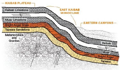
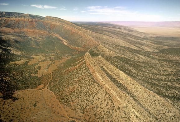
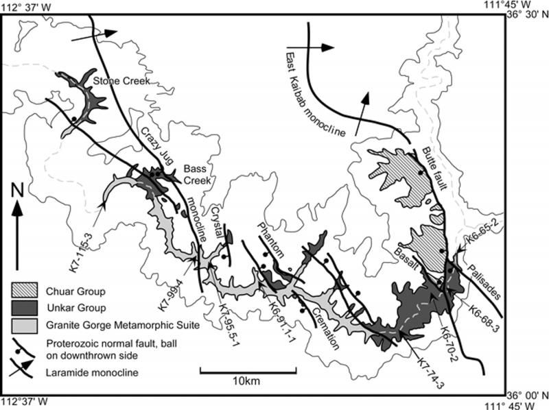
Proterozoic multistage (ca. 1.1 and 0.8 Ga) extension recorded in the Grand Canyon Supergroup and establishment of northwest- and north-trending tectonic grains in the Southwestern United StatesGeological Society of America Bulletin (February 2001), 13(2):163-180 quote: Essentially, this is stating that deep-seated, billion+ year old structures, in particular the ones responsible for down-dropping and preserving the Grand Canyon Supergroup, continued to become re-activated (and are possibly still active), resulting in the formation of monoclines that are presently visible across the surface of the Grand Canyon area and further out. Below is a graphic representation of the East Kaibab Mononcline and a photo.
Here is a map of the faults and monoclines from the above-referenced paper:
and by magma intrusions as well, that would be visible between layers as far more than the usual narrow sills but enough to distort the laying down of any subsequent layers above, and by bucklings and tiltings too, to layers WITHIN the stack,
Magmatic intrusions are the result of very specific geologic conditions, such as subduction, extension, hot spots, etc. Unless those conditions are present, and they aren't present everywhere as you can see today, magmatism will not occur. However, down in the Unkar Group, there is a lava flow and basaltic dikes and basalt, so at that time, extension may have been occurring. In addition, magmatic intrusions do not have to result in deformation of the surrounding or overlying sedimentary package. This only happens under certain conditions, mostly due to the type of magma invading the rock and the type of rocks surrounding the intrusion.
But in fact all these things appear on that cross section to have occurred afterward, and while it IS only a diagram I would trust the artist to be doing his or her best to reflect the reality understood by geologists.
The cross-section is a simplified graphical representation of a complex system. It does not incorporate all the details because that would be impossible. To get the details, you need to read the technical journals. Edited by roxrkool, : No reason given.
|
||||||||||||||||||||||||||||||||||||||||||
|
RAZD Member (Idle past 1435 days)  Posts: 20714 From: the other end of the sidewalk Joined:
|
... Steve Austin ... Another good reason to avoid creationist sites. I'll let the others deal with him.
And from Wikipedia on "Meander:"
A stream of any volume may assume a meandering course, alternately eroding sediments from the outside of a bend and depositing them on the inside. ANY VOLUME. Let's look at this in a little more detail, not just the quote-mine provided: Meander - Wikipedia
quote: The context tells us that they mean any volume that stays inside the banks of the river\stream, because only then do you get the erosion\deposition pattern they talk about. Further down:
quote: Again, obviously inside the banks of the river, so the volume can be any size as long as the flow stays within the banks. Flood flow over the banks will erode across the meanders and tend to fill them in. If you have a flood over the sides of the bank then the flow would follow the down valley curve as that is the steepest path and takes the least energy to follow. Post flood fantasy catastrophic cascading flow is by your definition over the banks of the river at the start ... and it would take the fastest (lowest energy) path to the sea. It would not follow the course of the Colorado River whether there before or after. It would not could not create meanders. Have you ever looked at how a flooded river flows? Floodplain - Wikipedia
quote: Seeing as there are no such floodplain until the river exits the canyon, no such deposition north and south of the rims of the canyon, there was no flow over the tops of the banks. And that means no fantasy flood. Enjoyby our ability to understand Rebel American Zen Deist ... to learn ... to think ... to live ... to laugh ... to share. Join the effort to solve medical problems, AIDS/HIV, Cancer and more with Team EvC! (click)
|
||||||||||||||||||||||||||||||||||||||||||
|
Atheos canadensis Member (Idle past 3027 days)  Posts: 141 Joined:
|
As for my source, I copied it out of his 1994 book Grand Canyon, Monument to Catastrophe, which I have (but I haven't read much of it I must admit). Googling it gets various creationist references as well as critiques of the book. He answers one critique HERE, and the book is listed at Amazon but doesn't have many reviews. Ah, excellent! Perhaps you would be willing to transcribe (or maybe even scan?) a somewhat fuller excerpt where Austin mentions some evidence for the assertion you quote. Ideally it would be nice to see figures 5.12 and 5.16 which the rebuttal I linked says are not at all alike and therefore cannot be used to support the conclusion that high-velocity flows produce meanders:
quote: The link you provided to Austin's defense of his work includes a further rebuttal:
quote: These two rebuttals both make the same point; the geologic features Austin is using to support the assertion you quote do not resemble each other and cannot therefore reasonably be used to draw the conclusion Austin draws. I hope you have not allowed this discussion of meanders (pleased though I am that you are addressing it) to distract you completely from our ongoing discussion about the brooding dinosaur. I await a clearer explanation of your objection to the law of superposition. If you cannot present evidence that the law superposition is in error, then I think you must logically concede that the Flood could not have deposited an in situ brooding dinosaur in terrestrial deposits near the top of the rock record. I'm finding the sudden shift away from this topic, just when a conclusion seemed to be within reach, to be rather jarring.
|
||||||||||||||||||||||||||||||||||||||||||
|
JonF Member (Idle past 198 days) Posts: 6174 Joined:
|
Austin committed fraud in both his "study" of Grand Canyon lava and in his "study" of lava from Mount Ngauruhoe. In real science that ruins your career, in creation "science" it gets you a lifetime sinecure. It's a bit late here, I'll pull the evidence together tomorrow morning.
|
||||||||||||||||||||||||||||||||||||||||||
|
JonF Member (Idle past 198 days) Posts: 6174 Joined:
|
I would expect the deluge to have simmered down to a river by stages, including a stage where it was very deep and very fast and capable of cutting deep meanders. "Very deep and very fast" is not compatible with "cutting deep meanders". If there are no meanders to start with, deep and fast cuts straight. If there are existing meanders, deep and fast severely undercuts the walls as the water rounds the bends. Neither of which is present in the GC. And from Wikipedia on "Meander:"
A stream of any volume may assume a meandering course, alternately eroding sediments from the outside of a bend and depositing them on the inside. ANY VOLUME. I didn't confuse volume with velocity. Yes you did, exactly. You wrote about very deep and very fast. When challenged, you posted a quote that meanders can be cut by a river of, as you put it, ANY VOLUME. ANY VOLUME is not ANY VELOCITY. Fast is not about volume, it's about velocity. Slow flowing rivers that are very deep and wide have high volumetric flow rate and create meanders. Fast flowing rivers that are shallow and narrow have low volumetric flow rate and don't form meanders. Which isn't volume. Even though you can't keep the difference straight between velocity and volume. (I don't particularly trust that Wiki reference anyway, because "volume" is not the correct term. "Volumetric flow rate" or "volume flow rate" are correct. But I see RAZD has exposed your quote-mine.) And you are still avoiding the fact that fast-flowing streams do not create meanders, and fast and deep streams do not cut incised meanders with straight walls, they undercut the walls. Edited by JonF, : No reason given.
|
||||||||||||||||||||||||||||||||||||||||||
|
Faith Suspended Member (Idle past 1474 days) Posts: 35298 From: Nevada, USA Joined: |
I gave the Austin quote for the fast part and the Wikipedia quote for the deep part. I did not confuse them.
If fast is a problem make it deep alone, deep it certainly would have been.
|
||||||||||||||||||||||||||||||||||||||||||
|
Faith Suspended Member (Idle past 1474 days) Posts: 35298 From: Nevada, USA Joined: |
I don't want to get into this, just forget I ever posted anything from Austin if it's going to be contested, I'll check up on it some other time.
|
||||||||||||||||||||||||||||||||||||||||||
|
Faith Suspended Member (Idle past 1474 days) Posts: 35298 From: Nevada, USA Joined: |
I believe the Flood had to have done it but I'm not interested in arguing with you about the specifics, about the dinosaur or any other issue you've raised. You can consider yourself the winner of the argument.
|
||||||||||||||||||||||||||||||||||||||||||
|
Faith Suspended Member (Idle past 1474 days) Posts: 35298 From: Nevada, USA Joined: |
Faith writes: The point is WHEN they were disturbed. The fact that such a long block of strata ARE undisturbed calls the Old Earth interpretation into question, since it seems to me one should normally expect a lot of disturbance over the hundreds of millions of years represented there but it doesn't exist. But the schematic does show a lot of disturbance - it shows a large bending and uplifting and fissures plus some large anomalies at each end of the section. What more would you expect and why? It's also just a schematic, i suspect the reality is far more complicated than that. Yes it shows a LOT of disturbance, Tangle, ALL AFTER ALL THE STRATA WERE ALREADY LAID DOWN. Sure the reality is going to be more complicated, but any complication on the scale you are noting here, that occurred DURING the laying down of the strata, would certainly have been indicated on the diagram. This leaves the hundreds of millions of years during which the strata were BEING laid down unaffected by any of these sorts of disturbances, which ought to be recognized as highly unlikely, calling into question the hundreds of millions of years.
And the fracturing and uplift so clearly came AFTER all the strata were in place it contributes to that same interpretation -- those disturbances didn't happen as the strata were being laid down, they happened to the entire stack as a whole AFTER it was all in place.
Is anyone saying otherwise? Dr. A is trying to with some of his pictures, which I think prove MY point and not his; but no, mostly it's not being challenged. The problem is that it implies hundreds of millions of years of NO disturbances, which makes little sense on a planet that supposedly would have undergone the sorts of disturbances we are aware of in our own time, those faults and tiltings of strata and volcanic deposits that should have occurred between layers over hundreds of millions of years -- I mean like those we see at the top of the formation, not the narrow sills, but magma that would interfere with the laying down of any subsequent strata.
Again, the whole scenario should call the OE interpretation into question it seems to me. Unless they want to argue that the planet really was that placid for that many hundreds of millions of years as some have hinted they may.
I have no reason to expect the entire planet to be broken into small pieces and jumbled up and that's obviously not what we see. I would expect very many large sections to remain undisturbed for millenia otherwise the sediments couldn't form they way they have could they? We're not talking millennia, Tangle, we're talking HUNDREDS OF MILLIONS OF YEARS. But even millennia on this active planet record lots of such disturbances, so just because you happen to like the idea of such long periods without any disturbances, you have to explain how that is possible on THIS planet. I could argue THAT way for the Flood, you know. Well, it just IS that way and I know the Flood occurred, therefore the Flood did it. And as a matter of fact I believe that, but I do try to argue from the evidence itself if I can. But really, such a long stretch of undisturbed strata is easy enough to explain over a few thousand years, it's those hundreds of millions that call it into question.
|
||||||||||||||||||||||||||||||||||||||||||
|
Faith Suspended Member (Idle past 1474 days) Posts: 35298 From: Nevada, USA Joined: |
You wanted me to give an explanation of the depositional facts in those charts and I did so in the previous post.
Not so much, sorry. My my. Well, I did as much as Percy did in that post you recommended I take as my model. I guess it's enough for him but not enough for a creationist. Hm?
I’d like to point out that this is speculating, what I’m doing, and Percy was also speculating in that post you recommended to me, message 508 I think(?), about why there are blank areas in the layers according to Old Earth thinking. I’m saying this because back there you said you wanted to put this up to show me that scientists aren’t speculating but dealing with evidence or facts. But really, all this demonstrates that you ARE speculating and you cannot help speculating, it’s all you CAN do, with the sciences of one-time events in the past such as the deposition of the strata and how to interpret them.
There is a clear distinction between speculation and basing conclusions on evidence. You are missing the point. Of course. I'm talking about speculations BASED on evidence, on what's available for observation, such as the cross sections I like so much.
Of course, there is uncertainty when dealing with events that happened long, long ago, but speculation either does not have enough information to make an inform conclusion or ignores that evidence. Basing conclusions on evidence means studying ALL available evidence and comparing it to processes that are known to happen (in labs or in nature) and THEN drawing conclusions. Another important factor of evidence based conclusions is that when new evidence is presented, the conclusions also change; they cannot be held to dogmatically (although sometimes it may take a while for the change). Sanctimonious lectures seem to be very popular around here. There is no new evidence that contradicts what I've been saying about the cross sections. Please do try to follow the argument.
As for when it was laid down, I figure this must have been one of the earliest layers to have been deposited by the Flood, at least it’s the first one that’s still intact enough to be represented on a chart.
What type of deposit would you expect to be the FIRST deposit to be laid down after the flood (say on day 41 after the rain and turbulence subside) and why? I have no particular expectations, why should I? I was talking about what can be seen on the cross section and that's the lowest one represented there, as I said.
And this is flatly said to have been deposited at the bottom of a shallow sea simply because limestone is often found at the bottom of a shallow sea. The way all these landscapes and comings and goings of seas are determined is simply by ASSUMING that the layer was laid down at its place of origin and its contents, of sediment or fossils, are the key to what sort of landscape was present at the time.
How is sediment deposited, Faith? Have you ever been to a place where sediment is being actively deposited? Have you read anything written by someone who has actually studied these areas? This stuff is pretty much "common knowledge" now-a-days. You aren't even thinking about what I just said. When you start thinking about it, let me know.
Well, there are fossilized plants embedded in it, THEREFORE it had to have been above water, where the plants grew, right? Right where it is. But again, if the Flood explanation is correct, the mud or clay was merely carried from somewhere else, along with the plant life within it, by the ocean currents which laid it all down as a layer on top of the former layer.
Again, how could this possibly work? How could this whole terrestrial ecosystem be transported by flood waters and deposited as an intact unit? It is impossible. It ISN'T a whole intact terrestrial ecosystem, it's things that got picked up from some location or other and deposited as a layer here. And PLEASE consider the question of why one would ever expect an "ecosystem" or a time period of millions of years to be encased in a flat slab of rock. Nothing happening on this earth NOW supports such a notion.
You wanted me to explain how all this could have occurred in the 150 day time frame, which you find impossible, but that can only be because you are accepting most of the Old Earth view of it all. But if it was all just sediments and living things that got moved around and sorted out into layers by the worldwide Flood there’s no reason it couldn’t all have happened easily within months, or the whole Flood year or some such time period
There needs to be some mechanism that can do this type of "sorting." There is no such mechanism that exists. Henry Morris did hydraulic studies on these things, and so did somebody Berthault. Water DOES sort sediments, as can be seen deposited by rivers and even under the ocean. Ocean water IS ITSELF sorted into layers and currents. Waves deposit all of one kind of sediment at a time. Precipitation out of standing water also sorts out different kinds of sediments. There is NO problem with the idea that WATER sorts things even if we don't know exactly how in a particular case. So you can drop your "no such mechanism" claim because you are very wrong.
So, you need to posit divine intervention in the sorting of the layers - one that creates a deceptive picture of the history of the earth that has led countless millions of people astray from a "Biblical Christian" perspective, even devout and dedicated Christians such as me who do believe the Bible to be the inspired Word of God. I don't know how anybody can call the Bible the inspired Word of God and reject the first 11 or so chapters of Genesis.
Why would he do that? Why would he not just let the layers sort naturally so that no one would be led astray by the actual evidence. I'll give you my suspicion as to why: We are told to believe, to have faith. If any supposed knowledge contradicts God's word it is our obligation to contend against it rather than just give in and accept it just because it gets a grip on our fallible intellects. We are always required to CHOOSE between God and this world. We encounter such tests of faith all the time, what makes science any more convincing than anything else? "Let every man be a liar, but God be true" is in scripture. Also we are to use God's appointed spiritual weapons against "every high thing that exalts itself against the knowledge of God" which the old earth sciences certainly do -- some like you manage to remain some kind of believer although I can't see how, but thousands of others have become atheists as a result of this stuff. If we reach the point where we can't summon any arguments against such God-denying claims, we should do what Kurt Wise did and just say OK they have the evidence but I'm sticking with the word of God anyway. "Though He slay me I will trust Him."
And no, the evidence does NOT support a global flood depositing the GC it is only the DENIAL of evidence that can support that proposition. Oh I believe it most certainly does and even my own limited argument USES the evidence to support the Flood. But if you can't see it, I recommend the position of Kurt Wise rather than deny God's word.
He goes on to consider two theories about the role of the Colorado River and I’d only mention that one of them is rather similar to my own idea that the uplift would have diverted the river if it was already there, which he says it was, but that’s the only similarity with my guess.
I think this illustrates that scientists are willing to admit uncertainties in their theories. How the Colorado came to find its current course is still debated and there is evidence that supports both scenarios. Fine, but my own was not taken seriously and if both are to be considered so should mine. Face the fact that half this argument is nothing but entrenched bias against creationism and not a lot of actual science at all.
|
||||||||||||||||||||||||||||||||||||||||||
|
Tangle Member Posts: 9516 From: UK Joined: Member Rating: 5.1 |
Faith writes: The problem is that it implies hundreds of millions of years of NO disturbances, which makes little sense on a planet that supposedly would have undergone the sorts of disturbances we are aware of in our own time, those faults and tiltings of strata and volcanic deposits that should have occurred between layers over hundreds of millions of years -- I mean like those we see at the top of the formation, not the narrow sills, but magma that would interfere with the laying down of any subsequent strata. The earth's surface area is about 200m square miles and in that section we're looking at a tiny proportion of it. I don't find it at all surprising that there are sections of the earth that have remained relatively undisturbed for hundreds of millions of years. Not all the earth is geologically active - at least not in the sense you mean, volcanic and tectonic - the rocks in those formations are sedimentary, for them to form at all they need long periods of calm as they gradually build, compact and finally cement. I also suspect that if you actually looked at those rocks you'd find plenty of evidence of movement and faulting - just not on the catastrophic scale you are asserting is always necessary. You're also looking at a schematic showing - at a rough count - 10 layers that are relatively undisturbed but a further 15 on top of them that have been totally eroded. If you looked at the section to the right of the diagram alone, you wouldn't know that there had ever been a further fifteen layers above the 10 you're looking at and being amazed that they hadn't been interfered with by time. In other words, you are being surprised, only because you are seeing what HASN'T yet been disturbed but ignoring what has. You don't know what is missing from the picture, but are surprised by what is there.Life, don't talk to me about life - Marvin the Paranoid Android
|
||||||||||||||||||||||||||||||||||||||||||
|
Faith Suspended Member (Idle past 1474 days) Posts: 35298 From: Nevada, USA Joined: |
I guess you prefer your notions about an inactive earth and even fault lines that wouldn't be visible on that cross section, and far be it from any Geologist here to straighten you out so I'll leave you to it. But this part I have to respond to:
You're also looking at a schematic showing - at a rough count - 10 layers that are relatively undisturbed but a further 15 on top of them that have been totally eroded. If you looked at the section to the right of the diagram alone, you wouldn't know that there had ever been a further fifteen layers above the 10 you're looking at and being amazed that they hadn't been interfered with by time. In other words, you are being surprised, only because you are seeing what HASN'T yet been disturbed but ignoring what has. You don't know what is missing from the picture, but are surprised by what is there. This is some weird thing I can't even follow, but the layers to the left are the Grand Staircase and I've included them in all my discussions, also my theory about how the whole area got eroded as it is by all those disturbances we're talking about, and your notion that I'm "surprised" by any of it is just off the wall. Probably because you haven't been following the argument until recently. Oh well, what do I expect? Edited by Faith, : No reason given.
|
||||||||||||||||||||||||||||||||||||||||||
|
|
Do Nothing Button
Copyright 2001-2023 by EvC Forum, All Rights Reserved
![]() ™ Version 4.2
™ Version 4.2
Innovative software from Qwixotic © 2024

 (1)
(1)