|

Understanding through Discussion |
|
|
Register | Sign In |
|
QuickSearch
Summations Only | Thread ▼ Details |
|
Thread Info
|
|
|
| Author | Topic: Why the Flood Never Happened | ||||||||||||||||||||||||||||||||||||||||||
|
Percy Member  Posts: 22505 From: New Hampshire Joined: Member Rating: 4.9
|
Faith writes: You'll have to forgive me but this round of debate is the first time anyone has ever suggested that lithified rock bends at ALL, no matter what the distances involved. Now it's become the Argument Du Jour. Obviously because it gives you a way to deny the implication that the strata were still damp. This is just you making things up again. There's no such thing as damp, flexible rocks drying out to become hard rock. It's pressure that turns sediment to rock, not evaporation. Rock is not some supernatural material that doesn't bend. No material has a flexural strength of infinity. And you've been misreading that diagram and wrongly thinking that the horizontal and vertical scales are the same. They're not. Around the Grand Canyon, the amount of bending over a couple hundred miles is probably only a mile or two. Were the diagram to scale the amount of bending would be barely discernible. Each individual layer is only a few hundred feet thick at most. If you had a hundred inch long slab of an incredibly strong rock like granite that was only a tenth of an inch thick, which is about the same proportions as a layer at the Grand Canyon, you would be able to see the bend, and sedimentary rock has much less flexural strength than granite and would bend much more. The only reason you made up a story about damp rocks is because you didn't know the diagram exaggerated the degree of bending and that the deformation is actually very slight, and because you didn't know rock can bend by small amounts, and because you didn't know the sedimentary layers are not continuous slabs of solid rock but have existing fractures and new ones can be easily created, and because you cannot seem to figure out that the deformation takes place very slowly over eons, not suddenly.
But really it doesn't matter because the more important point is that they were all already laid down when the tectonic and other disturbances occurred, such as the creation of the Kaibab monocline itself. Any sedimentary layer being laid down after those events would not have conformed to the new slopes no matter how many miles in length, they would have laid themselves out most nicely horizontally and butted up against any such obstacles, perhaps piling up there, who knows, but they wouldn't conform to the new shapes. You must be misunderstanding something. No sedimentary layers could have been created after the region around the Grand Canyon was uplifted. At that point it could only experience net erosion, not deposition.
This time around at least people are conceding that point though. Again, you must be misunderstanding something. No one would concede the point as you've described it above, because it's dead wrong. But I don't understand why you keep insisting that the layers are all so flat. They're certainly roughly flat, but the thickness of each layer varies by as much as hundreds of feet, and this couldn't be true if the boundaries between layers were all flat. --Percy
|
||||||||||||||||||||||||||||||||||||||||||
|
Percy Member Posts: 22505 From: New Hampshire Joined: Member Rating: 4.9
|
Faith writes: I don't CARE about the meanders,... The reason the meanders are important is that rapidly moving water cannot create meanders.
I haven't studied it enough to get into a debate about it. Then it should be apparent to you, as it already is to everyone else, that you don't know enough about geology to be having this discussion.
In order to get out of them I'll just concede the point. You win this round. These concessions are dishonest and deceitful because you don't mean them. You've pulled these kinds of stunts far too many times to fool anyone. --Percy
|
||||||||||||||||||||||||||||||||||||||||||
|
Percy Member Posts: 22505 From: New Hampshire Joined: Member Rating: 4.9
|
Faith writes: One doesn't have to "make up" damp rocks when one is discussing what would have happened during and after the Flood, it's a natural assumption,... It could only be a "natural assumption" for someone incredibly ignorant, in the same way a child might believe it possible to be carried off by a bunch of balloons. If all it really took to create rock was to compress a slurry of some material like sand or clay or limestone and then let it dry out, then there'd be a huge industry creating synthetic rock. But there's no such thing as damp rock, and no such thing as drying out damp rock. In addition to great pressure it takes time to create sedimentary rock, and that's why there's no synthetic rock industry.
I have not been misreading the diagram. A slope is a slope I don't care how long a slope it is. I had a feeling that the explanation about the different coordinates being at different scales would go right over your head, and I see that that's the case. RAZD's compressed diagram didn't make things clear to you, I guess. I don't think he compressed it 30-to-1 though - looked a bit short of that.
I see, so now you are agreeing with me about the order of things that nobody agreed about for a long time. Wasn't it you who suggested that the Claron layer was deposited AFTER the Hurricane fault occurred? Now it's impossible, all that can happen after uplift is erosion. Oh goody, shift and shift. I have no idea what you're talking about now. I said nothing about the Hurricane fault and neither did you in your message. What you did say that I quoted was that, "Any sedimentary layer being laid down after those events would not have conformed to the new slopes no matter how many miles in length, they would have laid themselves out most nicely horizontally...etc...", and that's what I commented about. Obviously an uplifted region cannot be an area of net deposition. It's a mystery why you believe it so important for God to work his will without violating natural laws, but given that's the course you've chosen don't you think you should learn something about these natural laws, develop more of an intuitive feel for them, so that you stop inventing so many physically impossible scenarios? And when you can't figure out a natural solution, instead of putting your ignorance on display just say, "It's a miracle!" --Percy
|
||||||||||||||||||||||||||||||||||||||||||
|
Percy Member Posts: 22505 From: New Hampshire Joined: Member Rating: 4.9
|
Faith writes: I've argued this many times here before and don't want to get into it again now. Of course you don't want to get into it. Whenever your understanding stumbles forward enough for you to understand that an issue *is* actually important to your case, you abandon it. You didn't have any answers on these issues then, and you don't now. Try sticking with it for once instead of running away. --Percy
|
||||||||||||||||||||||||||||||||||||||||||
|
Percy Member Posts: 22505 From: New Hampshire Joined: Member Rating: 4.9
|
Faith writes: What's impossible is that idiotic idea that rocks represent landscapes that represent times on the earth. But this is just you mouthing off inanities again. Your strategy of finding natural explanations for Biblical stories is failing miserably because since you have no idea how nature works you just make it up. Even more inexplicably, you reject all the evidence and explanations for how nature really works. If your strategy is to convince people that the Biblical stories are true by finding natural explanations for them, then you have to find actual natural explanations, not fantasies.
But the Flood is the most natural explanation for layered rocks of different sediments with dead things inside them. The flood is the most natural explanation only to someone as completely ignorant of geology as yourself. Again, if you're going to be so obvious in demonstrating your disdain of how sediments are actually deposited by nature, how can you pretend to be seeking natural explanations? If you're really so determined to prove it wasn't miracles but just nature behaving naturally, then you have to begin describing things nature actually does.
I know very little about conventional Old Earth Geology,... There's no such thing as "Old Earth Geology", just geology, but you've made your ignorance abundantly clear. Those who study how rivers and floods behave have no particular stake in how old the Earth is, but more than that, much of what you reject is just simple common sense, like heavier sediment settling out first.
...and I don't want to know more, it's obviously just an elaborate fantasy into which a lot of genuine science is forced to fit, too bad. You know little about it, you don't want to know more about it, but you somehow know that it's wrong. Way to ruin your own credibility! Is trumpeting your ignorance and ineptitude really a good strategy?
I could be wrong about HOW various things happened concerning the Flood, but not about the Flood itself. How could the opinion of someone as ignorant of geology as you just described have any value?
In any case I think the scenario I've been pursuing is a pretty good one and that a great deal of it has been shown to be supported by actual evidence. Evidently, the only one who believes any evidence supports your position is you. You've already confessed a profound ignorance of geology, so from what fairy tale kingdom are you gathering this evidence? If the only way you can maintain your certainty that you're right is to also maintain your ignorance, how can you ever hope to find geological evidence supporting your views?
Of course any evidence can be turned to almost any purpose when it comes to speculations about the past,... If true that you really believe this then you're the only one, but I think you're being less than honest since then it would make no sense for you to argue so vehemently that the evidence supports your views. Which you just did in your previous sentence.
Oh and about that pressure and heat causing the rocks to be pliable, these rocks were VERY WET, which I would think might make a difference in the temperature and therefore the pliability based on heat, not that it matters anyway of course. This is just you making things up again. There's no evidence for any of this. It's a complete fantasy.
NOW I'D REALLY LIKE TO LEAVE THIS PLACE WHICH I EVEN WANTED TO DO AT THE BEGINNING OF THIS THREAD. Oh, come on. Could you please find a new schtick? --Percy
|
||||||||||||||||||||||||||||||||||||||||||
|
Percy Member Posts: 22505 From: New Hampshire Joined: Member Rating: 4.9
|
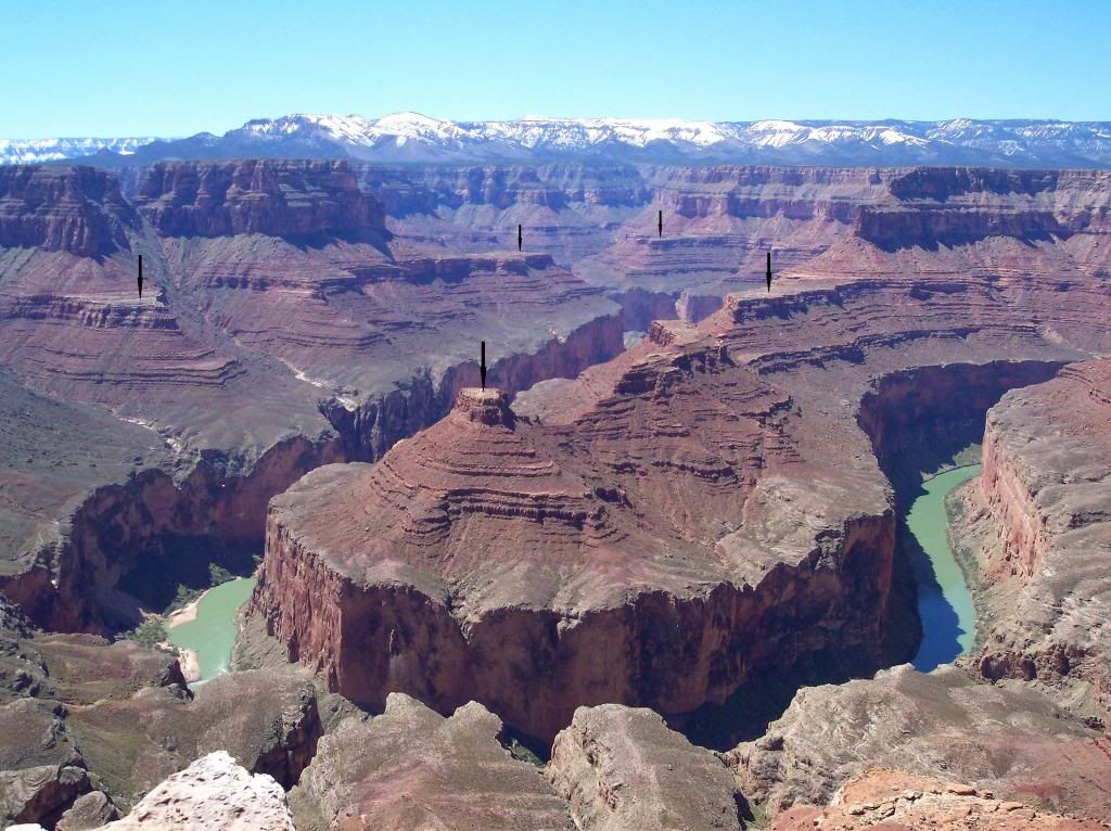
Just to help Faith identify which part of the Grand Canyon you're talking about for this image here:
This image is from this part of the Grand Canyon as shown here in Google Maps:
Here's a closeup:
The principle that Faith needs to understand is that violent, energetic rapidly moving water cannot carve gentle meanders. Faith also needs to seriously question her entire strategy of trying to explain the Biblical flood naturally by making things up about what nature can do that are as unnatural as miracles. --Percy
|
||||||||||||||||||||||||||||||||||||||||||
|
Percy Member Posts: 22505 From: New Hampshire Joined: Member Rating: 4.9
|
Just to help Faith understand the scale, the width of this meander is about one mile:
Also, Faith, if you click on the image to blow it up to full size and focus in on the high point on the inside of the meander you'll see that the slope descends from the peak in a series of ridges. Each ridge is covered with scree which has eroded from the ridges above. Each ridge represents a former level of the river. The river erodes to a lower level as the region uplifts. The exposed levels of the riverbank are subjected to the erosion and gradually retreat from the edge of the river. The longer the edges of the riverbank are exposed to erosion the more they retreat from the edge of the river. The highest levels have been exposed the longest and so have retreated the furthest. It takes a great deal of time for rock to erode away. The great amount of slope retreat shown in this image is more and very obvious evidence for an ancient river. --Percy
|
||||||||||||||||||||||||||||||||||||||||||
|
Percy Member Posts: 22505 From: New Hampshire Joined: Member Rating: 4.9 |
Faith writes: I give up. If I keep coming back here I'll go stark raving bonkers or have a stroke or something. What you had said that RoxRKool questioned was this in Message 882:
Faith in Message 882 writes: This is ridiculous. Your pictures of the CANYON's meandering are taken from high above, showing miles of the canyon. They do NOT show the tight HAIRPIN turns that the RIVER takes. A GIANT hairpin turn in the CANYON is NOT the same thing as a hairpin turn in the RIVER. The RIVER and the CANYON are two different things. The reason RoxRKool said this makes no sense is because the river carves the canyon. A canyon carved into rock is a record of the river eroding downward into an uplifting region for thousands and millions of years. The reason the canyon is so much wider than the river is because of slope retreat, which also takes a very long time. And as I pointed out in Message 889, the width of this meander is about one mile, showing the river *and* the canyon taking the very same (in your words) "tight HAIRPIN turn":
A mile is about on the same scale as the meanders for any river, which poking around a bit seem to range in width from a few hundred feet to a couple miles. --Percy
|
||||||||||||||||||||||||||||||||||||||||||
|
Percy Member Posts: 22505 From: New Hampshire Joined: Member Rating: 4.9
|
Faith writes: I don't believe it. Shall I scream and tear my hair out? I would suggest examining the evidence and seeking explanations consistent with physical laws and what we already know about the way nature behaves. --Percy
|
||||||||||||||||||||||||||||||||||||||||||
|
Percy Member Posts: 22505 From: New Hampshire Joined: Member Rating: 4.9 |
Faith writes: The level of delusion here is beyond belief. You know, it seems kind of ridiculous that you should be in this thread all by yourself. Bolder-dash and Marc9000 recently checked in after long hiatuses over at the The smoldering of EVC thread, and Marc even commented about what he felt was shabby treatment of you. Why don't you PM them and see if they'll help you out here? --Percy
|
||||||||||||||||||||||||||||||||||||||||||
|
Percy Member Posts: 22505 From: New Hampshire Joined: Member Rating: 4.9
|
Suggestion for your new avatar:
--Percy
|
||||||||||||||||||||||||||||||||||||||||||
|
Percy Member Posts: 22505 From: New Hampshire Joined: Member Rating: 4.9
|
Hi Faith,
Getting back to the meanders, the river meanders and the canyon meanders are one and the same. There is nowhere where the canyon meanders one way and the river meanders another. Your other objection to the Grand Canyon meanders was that they are too way big, but the meander that was provided as an example is only a mile across, which is pretty standard:
This image also contains a perfect example of slope retreat, which is caused by erosion of the riverbanks as the river carves more and more deeply into the landscape as the region uplifts. Such erosion takes a very long time and is more evidence of the ancientness of the Grand Canyon. Slope retreat at an angle could not be present on any rapidly cut canyon, whose sides would be vertical. --Percy
|
||||||||||||||||||||||||||||||||||||||||||
|
Percy Member Posts: 22505 From: New Hampshire Joined: Member Rating: 4.9 |
Just to clarify, BDT is Breached Dam Theory, which is Faith's scenario with breached glacial lakes flooding catastrophically over the landscape to carve the Grand Canyon, and RFS is Receding Flood Scenario, with the receding flood waters carving the Grand Canyon. The article (A receding Flood scenario for the origin of the Grand Canyon) takes the position that the BDT approach advocated by Faith is incorrect and instead advocates RFS.
Both approaches have all the same problems, except that RFS postulates even softer sedimentary layers than BDT. In either scenario, rock soft enough to be that quickly eroded would have slumped into canyon, especially the lowest layers which would practically have been extruded into the canyon by the sheer weight of the layers above. There's no evidence of any such slumping. Alos, if the sedimentary layers of the canyon were not yet lithified and so were still soft and unconsolidated when the canyon was formed, then those at the top of the canyon would have remained soft and unconsolidated because they had no overlying layers to compress them. Note to Faith: Looks like help has arrived. --Percy
|
||||||||||||||||||||||||||||||||||||||||||
|
Percy Member Posts: 22505 From: New Hampshire Joined: Member Rating: 4.9
|
Hi Faith,
I was able to find out more about the meander in this outlined area:
Here's the closeup image of the meander, which it turns out is named Point Hansbrough:
The photograph is incredibly rich in detail, so don't forget that you can click on it to see it enlarged. A key question that should be asked about Point Hansbrough is why the upper portion is sloped and the lower portion vertical. The answer is the differing rock hardnesses of the geologic layers. The upper sloped portion is the Supai Group, which is fairly hard sandstone, while the lower vertical portion is Redwall above Mauv, both much softer limestone. If you dig into the Redwall and Mauv layers you'll find that they're not really red. They're only stained red by water runoff from the overlying Supai Group. There was a point in time before the river had eroded down through the hard Supai Group layers into the softer Redwall and Mauv limestone layers. When the river finally did erode through the Supai Group it would have first occurred at a lower elevation many, many miles downstream from Point Hansbrough. Erosion through the limestone layers would be much faster than through the higher sandstone layers of the Supai Group, and in no time there would have been a good sized differential in height of the riverbed, i.e., a waterfall. Given the heavy sediment load of the Colorado and the much more rapid flow of water across a waterfall, the waterfall would have quickly cut back upstream, very neatly following the course of the river around all the turns and meanders. The nearly vertical sides of the Redwall and Mauv sections occurred because they were cut relatively rapidly, probably on the order of a few centuries. As mentioned before, when a river cuts into a landscape, or rockscape in this case, the riverbanks erode back away from the river. Each little sublayer of the Supai Group took thousands and thousands of years to erode away, and so the higher the Supai Group sublayer, the longer it has been eroding away. That's why each sublayer is so much smaller than the one below, and why the slope is around 45 degrees. The underlying Redwall and Mauv layers that were all eroded away quickly leaving vertical sides have also been eroding away. Notice the very deep scree at the base of the Mauv just above river level, which is the debris from all the above layers. Those who have memorized all the layers of the Grand Canyon might ask, "What about the Temple Butte layer that lies between the Redwall and the Mauv?" The answer is that it isn't present here. In many parts of the canyon the Temple Butte is only partly eroded away, but at Point Hansbrough it is completely eroded away, and I expect some of the Mauv, too. But here's an image from just a short ways downstream of Point Hansbrough of a small smile-shaped portion of Temple Butte Limestone underlain by Mauv limestone and overlain by Redwall:
Source This is a much more clear illustration of the effects on erosion on layers of an uplifted region before a subsequent subsidence when it begins collecting sediment again. A stream or river eroded a channel into the top of the Mauv, the region subsided and the channel filled with limestone sediment that we now call the Temple Butte, then the region was uplifted again and the Temple Butte eroded away in this area all the way down to the Mauv, except for this little section of creek or riverbed. --Percy
|
||||||||||||||||||||||||||||||||||||||||||
|
Percy Member Posts: 22505 From: New Hampshire Joined: Member Rating: 4.9
|
The other information I read while poking around said that in the distance is the Marble Platform and further away the Kaibab Plateau, for reference here's your image:
--Percy
|
||||||||||||||||||||||||||||||||||||||||||
|
|
Do Nothing Button
Copyright 2001-2023 by EvC Forum, All Rights Reserved
![]() ™ Version 4.2
™ Version 4.2
Innovative software from Qwixotic © 2024