|

Understanding through Discussion |
|
|
Register | Sign In |
|
QuickSearch
| EvC Forum active members: 65 (9164 total) |
|
| |
| ChatGPT | |
| Total: 916,916 Year: 4,173/9,624 Month: 1,044/974 Week: 3/368 Day: 3/11 Hour: 0/0 |
Summations Only | Thread ▼ Details |
|
Thread Info
|
|
|
| Author | Topic: Why the Flood Never Happened | |||||||||||||||||||||||||||||||||||||||||||||||||||||||||||||||||||||||||||||||||||||||||||||||||||||||||||||||||||||||||||||||||||||||||
|
RAZD Member (Idle past 1435 days)  Posts: 20714 From: the other end of the sidewalk Joined: |
Hi Faith
Well, what can I say to technical journal stuff? How can I answer those bald assertions of OE interpretive assumptions as if they were known fact? ... You could try reading them to see if they really are bald assertions or are supported by evidence.
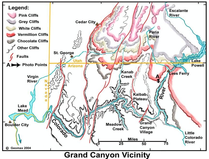
I guess you are happy with the number of faults you have found in the canyon as sufficient for the 750 million years in question? Also they are labeled with time period names, Pleistocene, and Proterozoic as if they occurred lower in the stack as I've been saying doesn't occur on the cross section. I don't know how they get those names but since they aren't shown on a cross section view I also can't comment on them. A guess would be that the stack is eroded away above that level so that the fault line just happens to end there by default. But there's no way to tell anything about it from the diagram you give. Except that the fault lines are in those locations and that they have been reactivated. Those fault lines also show in map here:
And I guess you are happy with the idea that the conditions for magmatic intrusions of the sort I say should be expected simply haven't been met in 750 million years? ... You do realize, I hope, that your argument here is based entirely on your incredulity rather than on objective evidence (ie - showing that no other place on earth has less activity)? This is an interactive map of Quaternary earthquakes in the US:
Different colors represent different ages ... Look at the Great Plains area -- N.Dakota, S.Dakota, Minnesota, Iowa, Nebraska -- an area much larger than the Colorado Plateau ... no fault zones Zoom in on the Colorado Plateau & Grand Canyon ... many fault zones The Great Plains would represent sedimentary deposition and large flat geography very similar to the layers of sedimentary deposits in the Colorado Plateau -- before uplift and tectonic stress build-up. Should there be earthquakes there? Not without cause -- earthquakes are a result of stress build-up in plates, so as long as there is no significant stress build-up one would be silly to expect earthquakes wouldn't you agree?
... Well, Percy did say lithified rock can stretch a lot. Me I'd have to guess that draping occurred at the same time as the uplift and the other disturbances. ... See Message 819 to see a better representation of the actual layer slopes (rescaled to approximate 1 horizontal to 1 vertical dimensions) - a lot of detail is lost but you can follow the color bands to see the slopes.
But you win Rox. All this stuff is pure mystification to me, ... But "mystification" can be remedied with learning - start with the basics : perhaps roxrkool can recommend some entry level textbooks and if you are interested I can buy one for you from amazon (you'd have to message me an address). Now my knowledge of geography is weak, but I love learning new stuff so I could order one for myself too and we could do a Great Debate Book Review discussion of the book, both of us learning as we go along ... Enjoy Edited by RAZD, : piclinkby our ability to understand Rebel☮American☆Zen☯Deist ... to learn ... to think ... to live ... to laugh ... to share. Join the effort to solve medical problems, AIDS/HIV, Cancer and more with Team EvC! (click)
|
|||||||||||||||||||||||||||||||||||||||||||||||||||||||||||||||||||||||||||||||||||||||||||||||||||||||||||||||||||||||||||||||||||||||||
|
RAZD Member (Idle past 1435 days) Posts: 20714 From: the other end of the sidewalk Joined:
|
My argument has been based all along on the fact of the huge disturbances that occurred in the canyon area after all the strata were in place. The supposed placidity lasted some 750 million years, only to be suddenly brought to an end ... Yes, you are incredulous that this occurred, but the question is whether we should be incredulous, based on evidence of "huge disturbances" ... and the consensus appears to be no, there is no reason to be incredulous about long term benign levels of activity. Faults occur where there is stress between plates, and if there is no stress there is no cause to expect faults occurring. Again I direct you to:
Message 821: This is an interactive map of Quaternary earthquakes in the US:
Different colors represent different ages ... Look at the Great Plains area -- N.Dakota, S.Dakota, Minnesota, Iowa, Nebraska -- an area much larger than the Colorado Plateau ... no fault zones Zoom in on the Colorado Plateau & Grand Canyon ... many fault zones The Great Plains would represent sedimentary deposition and large flat geography very similar to the layers of sedimentary deposits in the Colorado Plateau -- before uplift and tectonic stress build-up. ... That much larger area has no fault lines and that means no disturbances in over 1.6 million years.
... The supposed placidity lasted some 750 million years, only to be suddenly brought to an end ... And questions you need to answer is first is where 750 million years comes from and second what were the tectonic stresses during those years ... provide evidence that there was stress but no activity and you would have a conundrum. But there is another issue here, which revolves again around your concept of "huge disturbances" and what qualifies. The fault lines in the area of the Grand Canyon are shown on this map
And from the USGS map we know that some were <15,000 years ago (yellow), some were 15,000 to <130,000 years ago (green), some were 130,000 to <750,000 years ago (blue), and some were 750,000 to <1,600,000 years ago, and many of the younger colored ones show the recentest occurrence age rather than their oldest occurrence age.
... only to be suddenly brought to an end by all that tectonic and volcanic activity seen in the uplift over the canyon area, the cutting of the canyon into it, the stairs and canyons of the Grand Staircase to the north as well as the uplift there, and the magma dike at the end of the staircase that penetrates through all the strata to the very top where it's created a lava field, and the Hurricane fault that created the angular unconformity to the north of it, and so on. All of which occurred over a long period of some 40 million to 70 million years for the canyon to form (depending on which study you pick) or longer (possible pre-canyon activity). That doesn't seem to me to be a "sudden" occurrence at all, especially as a good part of it could have occurred well before then ... like the faults that recur along older fault lines, but I'm no expert here. One of the issues for whether they would "qualify" for your disturbances is whether they can be observed across the canyon ... so if all the faults are side-slip faults with no change in elevation then they could move "huge" amounts but not meet your qualification for observation. Likewise lack of observability does not mean that this did not happen. I just don't have the data to tell, nor do I feel I need to dig it out at this point because it's your argument to support not mine.
Of course there is also the activity that can be seen beneath the canyon as well, the Great Unconformity, the magma intrusions and so on, which are usually understood to have occurred BEFORE all the strata were laid down, long long long before. I rather think they occurred at the same time as those that clearly occurred afterward but either way you've got a lot of tectonic and volcanic activity in the region that supposedly DIDN'T happen at ALL for at least 750 million years. Curiously 750 million years of placid deposition in the environmental conditions for the deposition of the sedimentary layers does not disturb me, but I don't think your numbers add up (wiki):
quote: bold added for emphasis Coconino is group number 3 and the Supai group is number 5, well up the walls of the canyon. Sand dunes would leave evidence in the patterns of grains in different sizes (wind sorted) that would be visible, but maybe not across the canyon. Using the ages for the layers in the diagram I get a summary of the layers as follows:
From the top of the Great Unconformity to the current surface represents 525-270 = 255 million years not 750 million. Each level represents time spent where level deposition would be normal. Since then there was likely additional deposition that has subsequently eroded away. You can see why I have trouble with your 750 million year number here ...
Now I suppose you can just assume that's just the way it happened, but that of course strikes ME as a cop-out. The fact of so much disturbance to the entire area happening after all the strata were laid down kind of suggests that any former placidity of hundreds of millions of years is an illusion. But I guess that's just me. No, it would be a valid argument if you can show that there was tectonic stress in the area that should have caused the disturbances you are suggesting should have occurred. These things don't occur in cycles of a regular pattern, they are the result of tectonic stress. If there was no stress there is no reason to expect faults to appear on their own.
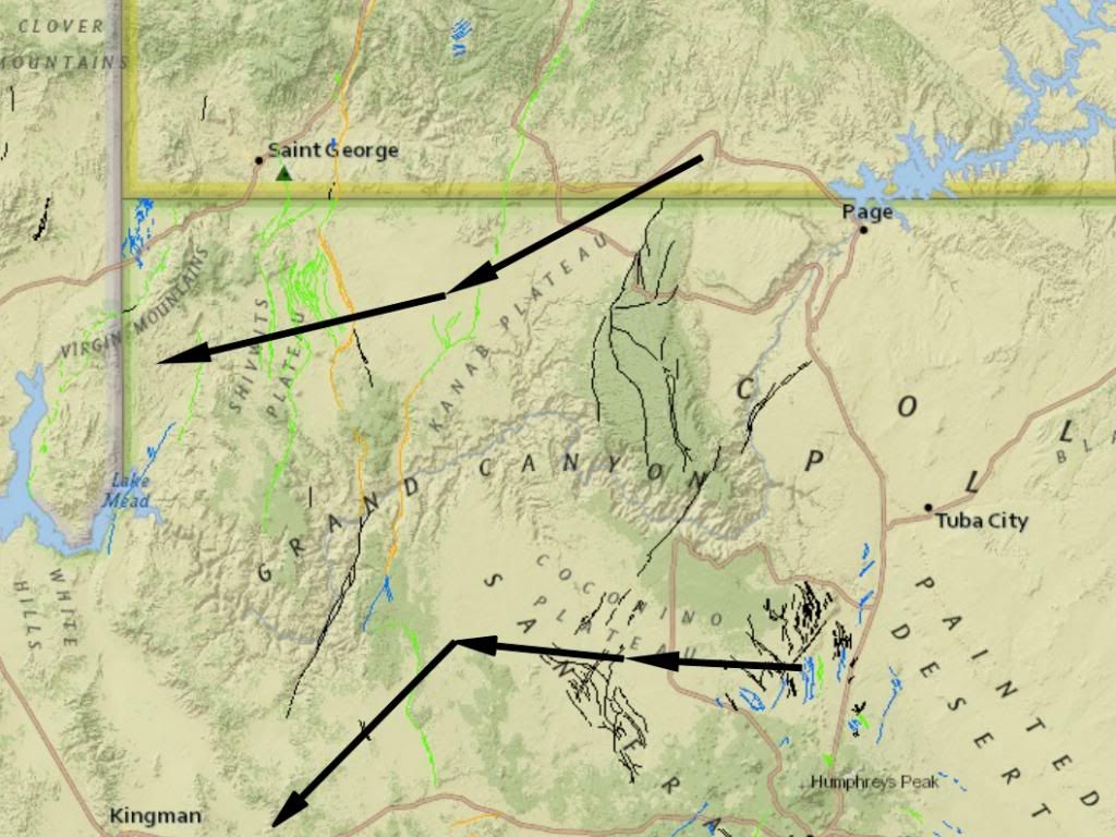
Oh but you need to recognize also that there are some here who are challenging the very idea of all that placidity, claiming there was such activity but it just didn't get recorded on the cross sections. Dr. A and Rox at least are trying to make that point. As do I Faith. Any side slip activity would not make it into your record, so we don't know from just looking across the canyon whether such activity occurred or not. There are lots of lesser disturbances that you choose to ignore, ones that show periods of erosion and periods of surface life. The Grand Canyon is just a small area and is really just a cross-section taken along the river course -- it doesn't represent the activity of the whole area. The only thing it represents well is the deposition of layers of sediment in a large geological column in several different periods of deposition. But I have another question for you: Why was the Grand Canyon location cut by flood waters when land to the north and south are lower at the top of the ridge and lower than the rim of the canyon such that they would form similar courses for the water to run west to the sea ... why are there no great canyons in these locations? This map again http://earthquake.usgs.gov/hazards/qfaults/map/ allows you to move around and zoom in and out, it shows elevations with color shading with light green lower than medium green, (the canyon is a darker green). There is a lower elevation in the ridge south of the canyon between Flagstaff and the south rim, and there is a lower elevation in the ridge north of the canyon where hwy 89 crosses the ridge on the way from Page Arizona to Kanab Utah.
Instead of taking either of these routes the Grand Canyon cuts across two (2) ridges at higher elevations. If this was flood drainage should not there be canyons of equal size or greater in these locations??? Enjoy. Edited by RAZD, : clrty Edited by RAZD, : piclinksby our ability to understand Rebel☮American☆Zen☯Deist ... to learn ... to think ... to live ... to laugh ... to share. Join the effort to solve medical problems, AIDS/HIV, Cancer and more with Team EvC! (click)
|
|||||||||||||||||||||||||||||||||||||||||||||||||||||||||||||||||||||||||||||||||||||||||||||||||||||||||||||||||||||||||||||||||||||||||
|
RAZD Member (Idle past 1435 days) Posts: 20714 From: the other end of the sidewalk Joined:
|
AND THE 750 MILLION YEARS WAS THE NUMBER DR. A GAVE FOR THE TIME TO BUILD THE STRATA FROM THE TAPEATS UP. I'D been SAYING A BILLION YEARS BUT THAT INCLUDES THE FORMATIONS BENEATH THE CANYONS. BUT YOU MISSED ALL THAT AND JUST WANT TO ACCUSE ME OF SOMETHING, ANYTHING. So you would agree that the dates shown for these layers means deposition from 525 mya to 270 mya? Note while you were busy replying I edited my post to sneak this table in
Using the ages for the layers in the diagram I get a summary of the layers as follows:
From the top of the Great Unconformity to the current surface represents 525-270 = 255 million years not 750 million. Each level represents time spent where level deposition would be normal. Since then there was likely additional deposition that has subsequently eroded away. You can see why I have trouble with your 750 million year number here ... That summarizes the diagram in wiki. I'll be glad to say ~250 million years of deposition without significant differential vertical displacement or major drainage channels (which would not form underwater). That leaves the vertical up and down compared to sea level (which can be attributed to sea level change rather than ground), and then rising to it's current elevations (which is a pretty visible disturbance imho).
I started talking about "huge" and "large scale" disturbances to differentiate between the INVISIBLE erosion that everybody tries to say exists, and the VISIBLE tectonic and volcanic disturbances. Doesn't matter what I say or why somebody will make up something to accuse me of. I know Faith -- the "INVISIBLE erosion" can't be seen across the canyon. You have to look at all the evidence, and that means getting up close and personal with the layers (that's what rock hounds and geologists do).
Sure, you can imagine into fact anything you like, RAZD, including hundreds of millions of years of no tectonic activity. Fine, that takes care of my argument right there. No need to continue. But I don't need to imagine anything that is objective empirical evidence, all I need to do is look at it. But when it comes to imagination, can you tell me ... Why was the Grand Canyon location cut by flood waters when land to the north and south are lower at the top of the ridge and lower than the rim of the canyon such that they would form similar courses for the water to run west to the sea ... why are there no great canyons in these locations? This map again http://earthquake.usgs.gov/hazards/qfaults/map/ allows you to move around and zoom in and out, it shows elevations with color shading with light green lower than medium green, (the canyon is a darker green). There is a lower elevation in the ridge south of the canyon between Flagstaff and the south rim, and there is a lower elevation in the ridge north of the canyon where hwy 89 crosses the ridge on the way from Page Arizona to Kanab Utah.
Instead of taking either of these routes the Grand Canyon cuts across two (2) ridges at higher elevations. If this was flood drainage should not there be canyons of equal size or greater in these locations??? Enjoy. Edited by RAZD, : piclinkby our ability to understand Rebel☮American☆Zen☯Deist ... to learn ... to think ... to live ... to laugh ... to share. Join the effort to solve medical problems, AIDS/HIV, Cancer and more with Team EvC! (click)
|
|||||||||||||||||||||||||||||||||||||||||||||||||||||||||||||||||||||||||||||||||||||||||||||||||||||||||||||||||||||||||||||||||||||||||
|
RAZD Member (Idle past 1435 days) Posts: 20714 From: the other end of the sidewalk Joined: |
AND THE 750 MILLION YEARS WAS THE NUMBER DR. A GAVE FOR THE TIME TO BUILD THE STRATA FROM THE TAPEATS UP. Message 570 Dr A: No they didn't. There's only about 750 million years between the Grand Canyon Orogeny and the Laramide Orogeny. Three-quarters is less than two, I counted. Not the same thing Enjoyby our ability to understand Rebel American Zen Deist ... to learn ... to think ... to live ... to laugh ... to share. Join the effort to solve medical problems, AIDS/HIV, Cancer and more with Team EvC! (click)
|
|||||||||||||||||||||||||||||||||||||||||||||||||||||||||||||||||||||||||||||||||||||||||||||||||||||||||||||||||||||||||||||||||||||||||
|
RAZD Member (Idle past 1435 days) Posts: 20714 From: the other end of the sidewalk Joined:
|
In outline form:
speleothemsterrestrial layers between marine layers surface erosion of layers in canyon wall fossil evidence of mature life ecologies in layers sloth skull and dung in cave meandering of canyon walls meandering within canyon walls no floodplains not like scablands not like Palouse canyon not like Mt St Helens ash canyon hydrodynamics and energy gradients lava dams (13) and finally:
Message 1 of If Caused By Flood Drainage Why is the Grand Canyon Where It IS? Enjoy Edited by RAZD, : updated linkby our ability to understand Rebel American Zen Deist ... to learn ... to think ... to live ... to laugh ... to share. Join the effort to solve medical problems, AIDS/HIV, Cancer and more with Team EvC! (click)
|
|||||||||||||||||||||||||||||||||||||||||||||||||||||||||||||||||||||||||||||||||||||||||||||||||||||||||||||||||||||||||||||||||||||||||
|
RAZD Member (Idle past 1435 days) Posts: 20714 From: the other end of the sidewalk Joined: |
Nice picture, take it back a notch and you can show the lower passes over the ridge while the canyon goes through at a point of rising slope, and then climbs over another high point at the left ... as I show on If Caused By Flood Drainage Why is the Grand Canyon Where It IS?
try that out on themby our ability to understand Rebel American Zen Deist ... to learn ... to think ... to live ... to laugh ... to share. Join the effort to solve medical problems, AIDS/HIV, Cancer and more with Team EvC! (click)
|
|||||||||||||||||||||||||||||||||||||||||||||||||||||||||||||||||||||||||||||||||||||||||||||||||||||||||||||||||||||||||||||||||||||||||
|
RAZD Member (Idle past 1435 days) Posts: 20714 From: the other end of the sidewalk Joined: |
The reason debate here is impossible is because we fall into the trap of debating on the non-Creationists terms. Creationism is not the arguing of Origins using science and reason, it is the admonition that it all started with a Creator. You are exhausted and frustrated because you've been backed into a corner, trying to answer hard questions purely with knowledge. Instead, try starting with the bigger questions. From my point of view if you believe in creation then you believe in what was created, that it provides true evidence rather than falsehoods, and science is just a tool to help us understand what was created and how it was done, rather than try to prove god/s from creation. Enjoyby our ability to understand Rebel American Zen Deist ... to learn ... to think ... to live ... to laugh ... to share. Join the effort to solve medical problems, AIDS/HIV, Cancer and more with Team EvC! (click)
|
|||||||||||||||||||||||||||||||||||||||||||||||||||||||||||||||||||||||||||||||||||||||||||||||||||||||||||||||||||||||||||||||||||||||||
|
RAZD Member (Idle past 1435 days) Posts: 20714 From: the other end of the sidewalk Joined:
|
Have you seen Message 26 and replies on the February, 2013, and beyond - Post of the Month thread?
A GIANT hairpin turn in the CANYON is NOT the same thing as a hairpin turn in the RIVER. The RIVER and the CANYON are two different things. A meander occurs when the banks of the river wiggle, wobble and sometimes turn back on themselves. Eddies in the river itself are not meanders, they are eddies. So you look at the canyon walls to see the meanders, both large scale with the rims of the canyon and small scale with the inner canyon walls (often they follow the same pattern). The picture Atheos canadensis posted shows those large scale meanders of the canyon rims. The pictures I have posted show the inner canyon meanders and their relation to the rims.
the bunched up (topographic) lines near the river show the inner canyon cliffs, while the white/pink edge shows the canyon rims. Enjoy Edited by RAZD, : piclinksby our ability to understand Rebel☮American☆Zen☯Deist ... to learn ... to think ... to live ... to laugh ... to share. Join the effort to solve medical problems, AIDS/HIV, Cancer and more with Team EvC! (click)
|
|||||||||||||||||||||||||||||||||||||||||||||||||||||||||||||||||||||||||||||||||||||||||||||||||||||||||||||||||||||||||||||||||||||||||
|
RAZD Member (Idle past 1435 days) Posts: 20714 From: the other end of the sidewalk Joined:
|
indeed, however I have a bigger question for you
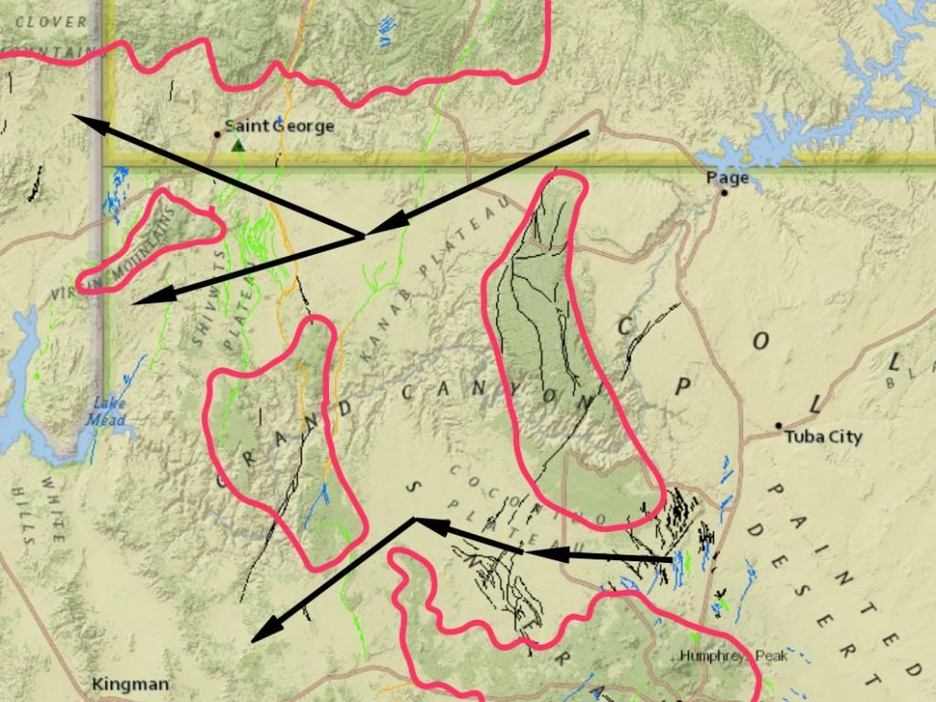
If Caused By Flood Drainage Why is the Grand Canyon Where It IS?:Why does the canyon cross two high ridges when paths north and south are at lower elevations?
The darker green is higher than the lighter green, the red outlines would be the topographic level dividing dark from light. So IF the canyon is formed by catastrophic flood flows draining the purported WWF, then
And why does the canyon cross higher land than either of these two paths? Enjoy Edited by RAZD, : piclinkby our ability to understand Rebel☮American☆Zen☯Deist ... to learn ... to think ... to live ... to laugh ... to share. Join the effort to solve medical problems, AIDS/HIV, Cancer and more with Team EvC! (click)
|
|||||||||||||||||||||||||||||||||||||||||||||||||||||||||||||||||||||||||||||||||||||||||||||||||||||||||||||||||||||||||||||||||||||||||
|
RAZD Member (Idle past 1435 days) Posts: 20714 From: the other end of the sidewalk Joined: |
cognitive dissonance causes discomfort when strong beliefs run counter to facts.
you could be near, be carefulby our ability to understand Rebel American Zen Deist ... to learn ... to think ... to live ... to laugh ... to share. Join the effort to solve medical problems, AIDS/HIV, Cancer and more with Team EvC! (click)
|
|||||||||||||||||||||||||||||||||||||||||||||||||||||||||||||||||||||||||||||||||||||||||||||||||||||||||||||||||||||||||||||||||||||||||
|
RAZD Member (Idle past 1435 days) Posts: 20714 From: the other end of the sidewalk Joined: |
The river created the meanders, the river was the last stage, it was left over from the Flood, it was not the Flood. Which is correct as far as it goes ... the trouble is that there is no evidence to support the flood drainage flows. Rather than delving more into the canyon let's look north and south of it. There are two paths, one north of the canyon and one south of the canyon where the ridge elevation is lower where they cross the (middle right) ridge than the Grand Canyon location where it crosses the ridge:
darker green is higher land than lighter green and I have drawn a topographic line for the elevation dividing dark from light. And there is another high point in the middle left where the canyon goes through while paths north and south have lower elevations. Why are there no similar canyons in those locations? Why does the Grand Canyon go through two high points? Enjoy Edited by RAZD, : piclinkby our ability to understand Rebel☮American☆Zen☯Deist ... to learn ... to think ... to live ... to laugh ... to share. Join the effort to solve medical problems, AIDS/HIV, Cancer and more with Team EvC! (click)
|
|||||||||||||||||||||||||||||||||||||||||||||||||||||||||||||||||||||||||||||||||||||||||||||||||||||||||||||||||||||||||||||||||||||||||
|
RAZD Member (Idle past 1435 days) Posts: 20714 From: the other end of the sidewalk Joined:
|
DAMP MODELING CLAY WILL CRACK AND BREAK. Saturated clay will bend, ... and you have fully saturated clay. Saturated sediments will liquefy and settle with fine particles rising while large dense particles sink (think quicksand) or flow downhill when shaken by an earthquake, ... and you have fully saturated sediments.
I SAID THE UPLIFT CAUSED THE CRACKING, NOT THE WATER. And the faults all seem to run north/south rather than east/west ... The reasons your arguments are wrong do not change with you repeating it in larger letters. Enjoyby our ability to understand Rebel American Zen Deist ... to learn ... to think ... to live ... to laugh ... to share. Join the effort to solve medical problems, AIDS/HIV, Cancer and more with Team EvC! (click)
|
|||||||||||||||||||||||||||||||||||||||||||||||||||||||||||||||||||||||||||||||||||||||||||||||||||||||||||||||||||||||||||||||||||||||||
|
RAZD Member (Idle past 1435 days) Posts: 20714 From: the other end of the sidewalk Joined: |
and saturated clay bends. your clay has been underwater for ~a year.
Just think of making pots with 'ropes' of clay run round and round -- the way pots were first made. Enjoyby our ability to understand Rebel American Zen Deist ... to learn ... to think ... to live ... to laugh ... to share. Join the effort to solve medical problems, AIDS/HIV, Cancer and more with Team EvC! (click)
|
|||||||||||||||||||||||||||||||||||||||||||||||||||||||||||||||||||||||||||||||||||||||||||||||||||||||||||||||||||||||||||||||||||||||||
|
RAZD Member (Idle past 1435 days) Posts: 20714 From: the other end of the sidewalk Joined:
|
Thank you for the smiley
THOSE ROPES WILL CRACK AND BREAK TOO Curiously I've made pots this way without cracking or breaking. What is your mechanism for drying out the sediments once the flood vanishes? Enjoy. Edited by RAZD, : .by our ability to understand Rebel American Zen Deist ... to learn ... to think ... to live ... to laugh ... to share. Join the effort to solve medical problems, AIDS/HIV, Cancer and more with Team EvC! (click)
|
|||||||||||||||||||||||||||||||||||||||||||||||||||||||||||||||||||||||||||||||||||||||||||||||||||||||||||||||||||||||||||||||||||||||||
|
RAZD Member (Idle past 1435 days) Posts: 20714 From: the other end of the sidewalk Joined:
|
YOU MADE YOUR POTS WITHOUT STRETCHING THE ROPES, ISN'T THAT OBVIOUS, MR. POSTER OF ENDLESS IRRELEVANCIES? IF WET SEDIMENTS ARE STRETCHED THEY WILL REACH A CRACKING POINT. Actually you can stretch clay quite a bit, but really the irrelevance is you using clay as an example. Limestone is not clay, nor does it form underwater, sandstone is not clay. Wet sand is not clay. Unlithified sediments fall into cracks. Water does not flow faster in cracks it slows down. Enjoyby our ability to understand Rebel American Zen Deist ... to learn ... to think ... to live ... to laugh ... to share. Join the effort to solve medical problems, AIDS/HIV, Cancer and more with Team EvC! (click)
|
|||||||||||||||||||||||||||||||||||||||||||||||||||||||||||||||||||||||||||||||||||||||||||||||||||||||||||||||||||||||||||||||||||||||||
|
|
Do Nothing Button
Copyright 2001-2023 by EvC Forum, All Rights Reserved
![]() ™ Version 4.2
™ Version 4.2
Innovative software from Qwixotic © 2024


 (1)
(1)