|

Understanding through Discussion |
|
|
Register | Sign In |
|
QuickSearch
| EvC Forum active members: 64 (9164 total) |
|
| |
| ChatGPT | |
| Total: 916,902 Year: 4,159/9,624 Month: 1,030/974 Week: 357/286 Day: 13/65 Hour: 0/1 |
Summations Only | Thread ▼ Details |
|
Thread Info
|
|
|
| Author | Topic: Why the Flood Never Happened | |||||||||||||||||||||||||||||||||||||||||||||
|
Percy Member  Posts: 22504 From: New Hampshire Joined: Member Rating: 4.9
|
Faith writes: The strata WERE all laid down flat, in fact that is a principle of Geology, HBD, original horizontality. I'm not sure what HBD was trying to say, he didn't provide much detail. Obviously when first deposited layers are horizontal. Since his next point was about erosion he might have meant that the junction between layers isn't flat and can be something like this example from the Grand Canyon:
And what people have "shown" me, such as frako's last, are all the usual misunderstandings of what I'm saying, or refusals to get it or whatever, answering with a knee jerk mindless picture or two which in fact confirms what i've been saying, because the disturbances "shown" to me all occurred AFTER the time period in question, WHICH IS WHAT I'VE BEEN SAYING. Do you mean, for example, that erosion of the Temple Butte layer shown above eroded after it was buried? That's not possible.
There are some ambiguous ones that should have been discussed,... If there are things that haven't been discussed that you would have liked to have discussed then the fault can only be your own. You've ignored nearly half the messages posted to you. I'm still waiting for a clear description of the location of a lake at a higher elevation than the Grand Canyon, or if that's not what you're arguing, then how water got up into your cracks in the uplifted region.
...but the way this thread has galloped along that's just never happened although from time to time I've SAID they merely confirm what I was claiming. No evidence has confirmed anything you've claimed.
But nobody's paying attention really. I think your real problem is the opposite, that everyone's paying very close attention with the result that every time you make some boneheaded claim you get several replies. Here's a boneheaded claim right here:
THE CANYONS AND CLIFFS OF THE GRAND STAIRCASE RUN EAST-WEST. GO LOOK AGAIN. Given that I just posted this image of the Grand Canyon going south then west then north, it's incredible that you said this (again, the yellow box is the meander we were discussing a while back):
Here's the diagram you like so much again:
What you don't seem to understand is that this is a diagram, not an actual representation of where things are. The horizontal and vertical scales are considerably different. The diagram only runs very roughly north/south, and in reality it takes a couple sharp turns. The Vermilion Cliffs are not on a direct line from the Grand Canyon to Zion Canyon. The Vermilion Cliffs are north-northeast of the canyon, while Zion canyon is north-northwest. Your diagram heads from the Grand Canyon north-northeast to the Vermilion cliffs, then takes a hard left and goes east-northeast to Zion Canyon, then takes a hard right and heads north to Brian Head. Here's an image showing all these locations. I've put a red circle around the Grand Canyon, the Vermilion Cliffs, Zion Canyon, and Brian Head:
So is it now quite clear that your diagram doesn't run directly north/south? Can you see that the canyons shown crossing the diagram could run in any direction? Here's an image of the Vermilion Cliffs showing that they, too, run in all directions. Notice that in the east the cliffs run northeast to southwest, that in the south the cliffs run mostly east/west, and then in the west they run north/south, so that should put an end to this "THEY ALL RUN EAST/WEST" nonsense:
But if that's not enough for you, then here's an image of the Zion Canyon area showing that the dominant part of the canyon runs north/south, and that all the fault lines run north/south:
So can we hear no more of this nonsense about the Grand Staircase features all running east/west?
This is all nothing but an exercise in obfuscation. Yes, Faith, it is, but all the obfuscation and errors are on your side.
The cross section is quite adequate for the purposes for which I'm using it and I resent your telling me stuff any child would know about a diagram. Yes, Faith, we're aware that you seem to resent being provided accurate information, in this case that you've misinterpreted your diagram. Again. --Percy
|
|||||||||||||||||||||||||||||||||||||||||||||
|
Percy Member Posts: 22504 From: New Hampshire Joined: Member Rating: 4.9
|
Faith writes: I would LOVE to ignore your posts but you keep raising such idiotic possibilities you have to be answered at least sometimes. This is just you feeling disrespected and lashing out again. When you accuse someone of saying something idiotic then it's usually a good idea to point to something actually idiotic the person said.
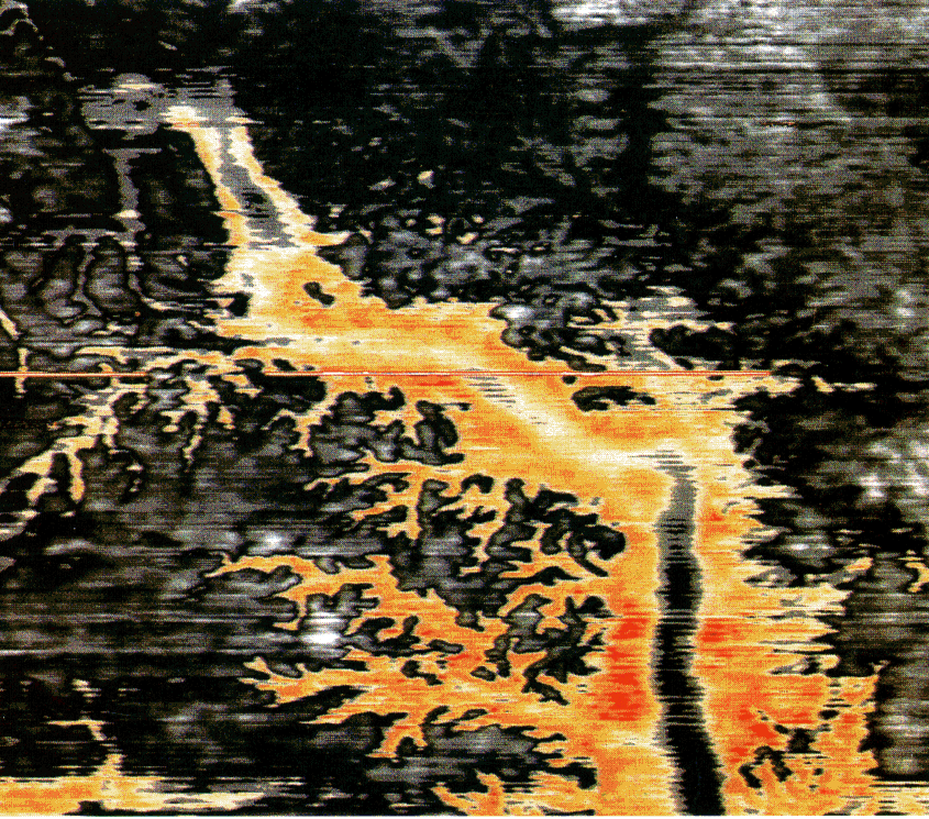
WHAT ARE THE DIMENSIONS OF THIS SUPPOSED CANYON ANYWAY? For supposedly scientific minds there's a strange lack of the usual necessary information for making any kind of reasonable judgment of a given subject. VERY BAD FORM. I don't know about the "very bad form" part since the image is very informative, but I agree that more information should be provided, and I already said exactly that in my Message 1749 in roughly the middle of that message. I *have* been able to dig up a little more information for you at Glenn Morton's We've Done Rivers, Let's Do Canyons webpage. About that image he says:
Glenn Morton writes: The first picture is of a dendritic incised canyon found underneath the Mahakam Delta, Kalimantan, Indonesia. Such features only form under subaerial conditions, not under water at all. Underwater canyons don't have that sharply dendritic pattern. It is from Alistair R. Brown, Interpretation of Three-Dimensional Seismic Data, AAPG Memoir 42, 1999, p. 115 You go on to ask:
Is it perchance in limestone? What is the evidence for slope retreat in that picture? Limestone is a very common layer, so the formation could easily be in limestone, but depending upon the depth of the canyon it could have cut through many different layers. We don't know. The evidence for slope retreat is that the canyon grows gradually deeper - that's what the differing colors indicate. The places where water would have flowed the longest in the main channel is also the widest.
There is nothing OBVIOUS about a river's forming that shape on the surface. Now you're just denying the obvious. Look at the image again. This is exactly what river drainage systems look like, and this one happens to have carved a canyon:
It has pretty much the same kind of form as canyons we see on the earth's surface, except this one is buried. It couldn't have formed underground because water doesn't flow that way underground. Underground there are no highlands for rain water to collect in and descend from, there are no landscape contours to gather rivers into channels. And limestone caves don't look like river systems.
If it formed in SOFT rock then the whole assumption that it would have taken time falls apart. Is this the kind of rock that dries again? There's no such thing. --Percy
|
|||||||||||||||||||||||||||||||||||||||||||||
|
Percy Member Posts: 22504 From: New Hampshire Joined: Member Rating: 4.9
|
Fatih writes: "Flat" means they have not been tilted or broken or otherwise altered in some OBVIOUS way. You keep complaining that no one understands what you're saying, and this is yet another example why. That is not the definition of "flat". Flat does not mean "not been tilted". Horizontal means "not been tilted." And "flat" does not mean "not broken". You certainly wouldn't say that a flat layer with a fault running through it somewhere wasn't flat. When no one can figure out what you're saying, the problem is you, not everyone else. The point that HBD is trying to discuss with you and that you keep finding lame and irrelevant reasons to not discuss is that there are features at the boundary between layers that can't be explained by a global flood. There are also features within the layers that can't be explained by the flood. Even the layers themselves can't be explained by the flood. But you have no answers for all that, so you find excuses for talking about everything but. --Percy
|
|||||||||||||||||||||||||||||||||||||||||||||
|
Percy Member Posts: 22504 From: New Hampshire Joined: Member Rating: 4.9
|
Faith writes: Should have known better I guess, 'cause this is Evo Wonderland where anything a creationist says will be so garbled and twisted and obscured beyond recognition within moments there's certainly no point in trying to say something that's less than simple. The true reason for your inability to communicate your ideas is that they are incomprehensible, incoherent, irrational, make no sense, and because they aren't based on evidence are vague, ethereal and ever changing.
The whole climate is supposed to have changed rather dramatically... This is based on neither Bible nor science. This is just you making up things again.
If the continental plates didn't start moving immediately then there must have been enough time for them to disperse to those great distances, including into the areas that became the new continents that were moving away from the original. More fantasy. --Percy
|
|||||||||||||||||||||||||||||||||||||||||||||
|
Percy Member Posts: 22504 From: New Hampshire Joined: Member Rating: 4.9
|
Faith writes: Try being honest. Try it yourself. In fact, what you should really try is being honest with yourself, because the only one you're fooling is you. You say that when you look at all the geologic layers that you see work of the Great Flood everywhere, but then you say it was a flood like no other, and that it did things no other flood has ever done, so having never observed one you couldn't possibly know what it would be like or what it would do. You don't even know that it would be different in any way (other than being larger) than floods on a normal scale. Saying you do know just isn't being honest. --Percy
|
|||||||||||||||||||||||||||||||||||||||||||||
|
Percy Member Posts: 22504 From: New Hampshire Joined: Member Rating: 4.9 |
herebedragons writes: So this area in brown, which represents most of the continental U.S. has not had major tectonic activity since the basement rock was laid down. But Arizona, the Grand Canyon, and the Grand Staircase, are in the purple area. --Percy
|
|||||||||||||||||||||||||||||||||||||||||||||
|
Percy Member Posts: 22504 From: New Hampshire Joined: Member Rating: 4.9
|
A true summary of a thread approaching 1900 messages would run on for pages and pages. so I'll just list the most absurd assertions from the other side:
--Percy Edited by Percy, : Minor clarification.
|
|||||||||||||||||||||||||||||||||||||||||||||
|
|
Do Nothing Button
Copyright 2001-2023 by EvC Forum, All Rights Reserved
![]() ™ Version 4.2
™ Version 4.2
Innovative software from Qwixotic © 2024