|

Understanding through Discussion |
|
|
Register | Sign In |
|
QuickSearch
Summations Only | Thread ▼ Details |
|
Thread Info
|
|
|
| Author | Topic: Evolution. We Have The Fossils. We Win. | |||||||||||||||||||||||||||||||||||||||
Faith  Suspended Member (Idle past 1475 days)  Posts: 35298 From: Nevada, USA Joined: |
You implied that your numbers falsified the old age of the earth. Obviously, geologists aren't using the same calculation as you are. So far I don't even know if geologists have done any calculations about the rates of erosion of the Monument Valley buttes or the walls of the Grand Canyon. I googled it and for the GC one site said a half million tons of sediment are removed from the GC daily, but that doesn't deal with the amount of erosion that collects at the base of the walls throughout the canyon. An entry on Monument Valley merely declares that the buttes have been shaped by erosion over millions of years with no hint that anybody's actually tried to measure it. Somebody at least estimated the rate for the hoodoos because it was given in a paper about the area, but how the rate was established wasn't discussed..
But even if the hoodoos did erode at the rate you claim, that has nothing to do with the age of the earth. Well, if a given formation is said to be such and such millions of years old in its present form but the rate of erosion would have reduced it to unrecognizable rubble in a few thousand years, or even hundreds of thousands, something's wrong with the way the time factor is calculated for the units that add up to the billions of years given for the age of the earth. That is, these formations represent particular time periods in the history of the earth so if they are still standing after the particular millions of years assigned to them, but their rate of erosion would have disintegrated them in far less time, a tenth of the time, a hundredth of the time, then they simply are not as old as Geology says they are. So if one formation dates to, say, the Cretaceous period which dates from 145 mya to 65 mya but its rate of erosion would have disintegrated it within thousands of years, or even give it ten million if you want, it simply is not as old as they say it is, and if it isn't that old neither is the Cretaceous period. If the formation has been clearly dated by its sediment or its fossils or its placement in the geological column, the whole time scale system falls apart. Edited by Faith, : No reason given. Edited by Faith, : No reason given.
|
|||||||||||||||||||||||||||||||||||||||
|
ringo Member (Idle past 443 days)  Posts: 20940 From: frozen wasteland Joined:
|
Faith writes:
What's wrong is your calculation. You can't use one back-of-the-envelope calculation to falsify millions of person-hours of work by thousands of geologists over two centuries. Well, if a given formation is said to be such and such millions of years old in its present form but the rate of erosion would have reduced it to unrecognizable rubble in a few thousand years, or even hundreds of thousands, something's wrong with the way the time factor is calculated for the units that add up to the billions of years given for the age of the earth.An honest discussion is more of a peer review than a pep rally. My toughest critics here are the people who agree with me. -- ringo
|
|||||||||||||||||||||||||||||||||||||||
|
jar Member (Idle past 425 days)  Posts: 34026 From: Texas!! Joined: |
PaulK writes: Since the height loss only applies to areas undergoing net erosion and because the hoodoo rate is well above that to be expected in a relatively level environment for reasons already discussed it doesn’t seem you have much of a point even there. And since the hoodoos started out at surface level and they did not grow instead the stuff that was around them eroded away it is all the shit that is not around them now that is what is important and would determine time spans.
|
|||||||||||||||||||||||||||||||||||||||
|
PaulK Member Posts: 17828 Joined: Member Rating: 2.5
|
quote: Do you think you could stop repeating the same silly mistakes ? Erosion isn’t magic. It won’t happen unless the rock is exposed. If a formation dates to the Cretaceous period then it must have been buried deeply to be lithified and it won’t start eroding until it is exposed again. The date that the sediment was deposited is no real help to you at all.
|
|||||||||||||||||||||||||||||||||||||||
|
Faith Suspended Member (Idle past 1475 days) Posts: 35298 From: Nevada, USA Joined: |
What's wrong is your calculation. You can't use one back-of-the-envelope calculation to falsify millions of person-hours of work by thousands of geologists over two centuries. That's not an objection to my calculation, it's an objection to my chutzpah. There's nothing wrong with my if-then logic, if the rate I found for the hoodoos is correct (2 to 4 feet of erosion per hundred years) it should have been eroded away completely well before the 30 to 40 million years of its official age. There shouldn't be one hoodoo left standing now. And there are so many lines of evidence against the Old Earth this isn't just one casual calculation, it merely confirms all the others. That film about sedimentation I posted back in Message 1140 gives dramatic evidence against the Old Earth by showing that the strata that are the basis of the time scale form rapidly in running water and in such a way that younger material may deposit beneath older material, challenging the whole Geological edifice and doing it with scientific experiments you can see for yourself in the film.
|
|||||||||||||||||||||||||||||||||||||||
|
ringo Member (Idle past 443 days) Posts: 20940 From: frozen wasteland Joined: |
Faith writes:
And as I've pointed out, that has nothing to do with the age of the earth. We know the earth is older than the hoodoos. Your calculation tells us nothing about how much older.
if the rate I found for the hoodoos is correct (2 to 4 feet of erosion per hundred years) it should have been eroded away completely well before the 30 to 40 million years of its official age. There shouldn't be one hoodoo left standing now. Faith writes:
It doesn't, though, does it? Every "alternate" method that creationists have for finding the age of the earth gives a different result. The reason for that is that you're dating things in the earth, not the earth itself. It doesn't matter if the hoodoos are five minutes old or five thousand years old. The fact is that there are older things in the earth. And there are so many lines of evidence against the Old Earth this isn't just one casual calculation, it merely confirms all the others.An honest discussion is more of a peer review than a pep rally. My toughest critics here are the people who agree with me. -- ringo
|
|||||||||||||||||||||||||||||||||||||||
|
Faith Suspended Member (Idle past 1475 days) Posts: 35298 From: Nevada, USA Joined: |
OK you're right, we need the age since exposure.
The most recent estimate for the age of the cutting of the Grand Canyon is five million years. Since on that cross section it appears to have been cut at the same time the Grand Staircase was formed, which includes Bryce Canyon with its hoodoos, then the hoodoos should also have five million years of exposure. Would the rate of erosion come anywhere near that? I can't find any information about Monument Valley's date of exposure but that whole area of the Southwest was exposed after all the strata were laid down so I'd give it the same five million years. In reality of course I know it was exposed at the end of rhe Flood like everything else in that area.. Edited by Faith, : No reason given. Edited by Faith, : No reason given.
|
|||||||||||||||||||||||||||||||||||||||
|
PaulK Member Posts: 17828 Joined: Member Rating: 2.5 |
quote: Please explain your reasoning.
quote: I really don’t know. The rate of erosion is obviously dependent on climatic variations - so I rather doubt it would be constant over millions of years. We have a lot of erosion needed to explain the existence of the hoodoos, too. Again, if you want to make an argument you need to do the work.
|
|||||||||||||||||||||||||||||||||||||||
|
Faith Suspended Member (Idle past 1475 days) Posts: 35298 From: Nevada, USA Joined: |
The Kaibab Uplift appears on the cross section to have been the main cause of the massive erosion over that entire area. It is all uplifted from north to south toward the Grand Canyon.
|
|||||||||||||||||||||||||||||||||||||||
|
Tanypteryx Member  Posts: 4451 From: Oregon, USA Joined: Member Rating: 5.5
|
Well, if a given formation is said to be such and such millions of years old in its present form Oh good grief, when the age of a formation is given, they are not talking about the present form. They are talking about when those sediments were deposited, not when they started eroding. In many cases erosion does not occur until millions of years after deposition. The sediments are deposited. More sediments are deposited covering the first sediments deeply. The first sediments are slowly turned to rock by the heat and pressure of being buried deeply. Eventually, the overlying sediments are eroded away exposing the first sediments, now turned to rock. The hardness of the rock is determined by the type of material, the depth it was buried and the length of time it was buried. If we take the case of Monument Valley, we know there were sedimentary layers not only filling all the space between the buttes, but deeply above the level of all the buttes. We know this because that is the only way the buttes could be turned to stone. Erosion has removed all the sediments that deeply buried the layers in and between the buttes. Then, erosion removed the material that was between the buttes. Now we have a large area with a few tall remnants of those layers in the form of buttes and spires that are continuing to slowly erode and that are surrounded by talus slopes of material that has fractured from the cliffs. The present form of Monument Valley is not the form that was deposited. It is the result of millions of years of erosion that removed all that other material. In the case of the hoodoos at Bryce, the hoodoos were not deposited in their present form. They were deposited as a layer which was not buried as deeply, or for as long and made of softer material so it erodes more rapidly than what we see in areas like Monument Valley or the GC. The material is eroding unevenly, leaving the hoodoos. There is no river eroding this material, rather it is chemical and mechanical weathering, mainly from snow and rainfall runoff. Rather than a real canyon it is more the side of a soft plateau being carried away.
So if one formation dates to, say, the Cretaceous period which dates from 145 mya to 65 mya but its rate of erosion would have disintegrated it within thousands of years, or even give it ten million if you want, it simply is not as old as they say it is, and if it isn't that old neither is the Cretaceous period. If the formation has been clearly clearly dated by its sediment or its fossils or its placement in the geological column, the whole time scale system falls apart. To clarify once again, the dates assigned to formations are the dates the sediments were deposited, not the date they begin eroding. Then they had to be buried deeply by more sediments for millions of years and turned to stone, Then the sediments burying them have to be eroded away, Then, millions of years after those particular sediments were deposited erosion begins removing material from the formation.What if Eleanor Roosevelt had wings? -- Monty Python One important characteristic of a theory is that is has survived repeated attempts to falsify it. Contrary to your understanding, all available evidence confirms it. --Subbie If evolution is shown to be false, it will be at the hands of things that are true, not made up. --percy The reason that we have the scientific method is because common sense isn't reliable. -- Taq
|
|||||||||||||||||||||||||||||||||||||||
|
PaulK Member Posts: 17828 Joined: Member Rating: 2.5 |
quote: Yet the Claron formation sits well above strata exposed at the Grand Canyon. It seems rather likely that that area has seen much less erosion.
|
|||||||||||||||||||||||||||||||||||||||
|
Faith Suspended Member (Idle past 1475 days) Posts: 35298 From: Nevada, USA Joined: |
Yes I know all that and took it into account in the last post. It's still supposedly five million years since the Grand Canyon was cut (although in reality it was cut after all the strata were laid down which would make it more recent than that since we have Holocene deposits). But on those five million years which would have to be the same timing for the hoodoos as I just explained, the erosion rates would still demolish the formation before now.
Edited by Faith, : No reason given.
|
|||||||||||||||||||||||||||||||||||||||
|
Percy Member  Posts: 22508 From: New Hampshire Joined: Member Rating: 5.4 |
All contact between all layers of all geological strata are "knife-edge tight." The great pressure of overlying strata eliminates all empty space and guarantees that there can be no gaps where one could insert a knife-edge.
No they aren't or there would have been no reason to point it out in that photo. But Baumgardner did not describe the contact as "knife-edge tight" in Noah’s Flood: The Key to Correct Interpretation of Earth History. He just said:
quote: Here's his version of the image:
There are no gaps in the boundaries between buried layers. The great pressure of the overlying layers renders that impossible. I don't know where you got the term "knife-edge tight" from, but I think you're misinterpreting it. It doesn't mean the lack of a gap between strata. It refers to how narrow and sudden the transition is. This is expected at a disconformity.
I wasn't objecting to the meaning of what Tanypteryx said, just pointing out my actual words. Why on earth you would make an issue of that is hard to understand. I was pointing out that your actual words seemed to imply something that isn't true. If by "knife-edge tight" you meant that there are no gaps between layers, implying that there are cases where there are gaps between layers, then that is not true. There are never any gaps between buried layers. There can of course be underground gaps and spaces in near-surface layers subjected to groundwater flow, but that's about it.
Original horizontality doesn't mean sameness of thickness, just that the overall lie of the layer is horizontal. If a layer isn't the same thickness throughout its extent, meaning that the top and bottom of the layer are not parallel with one another, then by what measure is it horizontal? If the top is horizontal? The bottom? A centerline drawn from one end of the layer to the other? What if none of these are horizontal? What if the top and bottom of the layer are not straight and flat? The layers at the Grand Canyon are only approximately horizontal.
Even Walther's Law won't make a layer climb up an incline. You still don't understand Walther's Law. A sea transgression is absolutely climbing an incline (in general, the elevation of the land increases with distance from the coast), just as a sea regression is descending an incline.
It would have to rise incrementally by the building up of the deposits. A sea transgression cannot move further inland, and deposits cannot become higher, without an increase in water level relative to the land. An increase in the level of the water relative to the land can be achieved in two ways, either by increase in sea levels or subsidence of the land or both. "Building up of deposits" by itself achieves nothing.
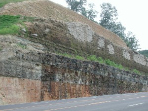
Erosion tends to level and flatten a landscape, so we should expect to find flat and level contacts at unconformities such as that at the top of the Hermit Shale Your efforts to find an example of such a perfectly flat and level surface have failed miserably. The evidence says you're wrong. These landscapes were produced by a combination of erosion and sedimentation:
How these layers not just as flat and straight as the strata boundary in this following image, which is only about a twenty foot stretch at most:
Plains and deserts are nowhere near the knife-edge closeness and straightness of the Coconino-Hermit contact. You appear to be changing the definition of "knife-edge" again. Do you mean no gaps, as you were saying earlier, or do you mean flat and straight, as you seem to be saying here.
That contact is presented BECAUSE it is rare or perhaps even unique, so your general statement about such unconformities is false. There's nothing rare or unique about that contact between the Coconino and the Hermit, except for the fact that it's at the end of an easily accessible trail and so gets photographed a lot. Erosion tends to flatten a landscape, and sedimentation upon a landscape that's been eroded flat will produce a straight and flat disconformity just like you see in the image.
And I'm sorry but I just don't get the point of all that business about transgressions and regressions, strikes me as irrelevant at best. I was trying to make something important clear. "Straight and flat" does tend to be a characteristic of unconformities, but "straight and flat" is by no means the rule. I used the example of the episodic nature of transgressions and regressions because they can result in strata boundaries that are very much not straight or flat or anywhere close to horizontal, as shown in this diagram provided by HereBeDragons:
It's remarkable that even a short stretch of it still survives after thousands of years. Why would it be remarkable for deeply buried geological strata to survive millions and billions of years? Rock that is completely protected from the elements would not be expected to change at all. It isn't protected from disturbances such as earthquakes and faults and magma intrusions which can unsettle buried rock, and tectonic force can drastically deform it even when buried. How is it remarkable that a short stretch of disconformity survived all these things, which happen in some places and not most others?
But I wasn't speaking theoretically, it was a simple observation that such a tight contact is rare even in an environment like the Grand Canyon where overall horizontality and straightness still exist to the naked eye, when at other locations it's rare to find even that much preserved. It's just an observable fact that the Grand Canyon preserves many features of the original deposition of the strata that are not preserved elsewhere. That's what makes the Grand Canyon especially valuable for this kind of discussion. Layers like those at the Grand Canyon are not unique. They're found all over the Southwest and in many parts of the world. These straight and flat strata are found in Salta, Argentina:
These straight and flat strata are found in Tennessee:
These straight and flat strata are found in a cut-though in Pikeville, Kentucky:
These straight and flat strata are from the French Alps:
So very obviously you are wrong to say that it is rare for straight and flat strata to be preserved.
The Grand Canyon is not preserving strata but exposing them to the elements. That is, the Grand Canyon is destroying strata, not preserving them. Sure, that's what makes the preservation of what has been preserved there so remarkable. The Grand Canyon is remarkable, and it makes the study of the geology of the region much easier than in most other places around the world, but there is nothing remarkable about the preservation of straight and flat strata.
The overall processes are of course destructive, but nevertheless original horizontality, straightness etc. are still clearly apparent. The same features are just as clearly apparent at many other places around the globe. There is nothing remarkable about the straight and flat strata at the Grand Canyon, besides the fact that that so much of them have been exposed.
Settling has occurred, erosion has occurred, there are areas where the walls have collapsed, but nevertheless what has been preserved in spite of all that IS remarkable and makes the Grand Canyon especially valuable for geological investigations. Exposure to erosion and weathering is not preservative. Burial is what preserves rock. The Grand Canyon provides remarkable access, not preservation.
The average rate of slope retreat in the Grand Canyon is around a half meter per thousand years. I think what you probably meant to say is that the Grand Canyon is exposing huge areas of strata making it possible for us to closely examine them. That's probably part of it but it's just my impression is that wherever strata are exposed elsewhere they tend to be distorted in ways that strata in the Grand Canyon are not. It's just a simple observation, Percy, you are making a major deal out of nothing here. Strata at the Grand Canyon are not much distorted, and as I showed above, lack of distortion is true of strata at many places around the world. The Grand Canyon is not in any way made unique or uncommon by the presence of straight and flat strata.
Complex sequences of tectonic forces have of course occurred in some parts of the world, usually near tectonic plate boundaries. The Grand Canyon is in the middle of the continent, very, very far from the nearest tectonic plate boundary. Perhaps that is the reason, but the reason isn't relevant since this is just a simple observation of fact. If by "simple observation of fact" you mean where you said that the Grand Canyon was an uncommon example of straight and flat strata, then no, you are wrong, as I illustrated above.
...as close to their original flat and straight horizontality as possible after thousands of years (after millions we'd be lucky to have a pile of dust left),... What forces or processes are you imagining could turn buried geological strata to dust? The GC strata I'm talking about are not buried, they are exposed, and they are being eroded and producing piles of eroded matter at the base of every formation. What you said was, "That's the beauty of the Grand Canyon, huge areas of strata are preserved as close to their original flat and straight horizontality as possible after thousands of years (after millions we'd be lucky to have a pile of dust left),..." "Preserved" can only refer to buried strata. Strata on the canyon walls are *exposed* to erosion, not preserved. And even after the passage of some millions of years the strata visible in the canyon walls will be still be pretty much just like they are today, only a few feet further away.
But in my opinion nowhere near enough erosion as should have occurred in the millions of years the canyon has been there, seventeen million or five million or whatever. In my opinion the amount of erosion is about right for the 4500 years since the Flood but way too little for millions of years as the Old Earth theory has it. That's my assessment of what I actually see. Wherever strata have been exposed for even more millions of years I'd expect it all to be reduced to rubble and dust, and even five million years might be enough for that to occur. The slope retreat you describe above is the only "force" I have in mind, all due to regular erosion from the exposed walls of the canyon. You are terrible at math. The rate of slope retreat (which is the rate at which the canyon walls are being eroded) is approximately 1.6 feet per thousand years. That amounts to about 10 miles (5 miles for each canyon wall) in seventeen million years, which happens to be the average width of the canyon. The width of the Colorado River was never 10 miles. When the region began uplifting the Colorado began cutting into the landscape creating slopes on the side, which began the slope retreat process that is driven by erosion.
Again, the enormous overlying pressure of geologic strata completely rules out any possibility of gaps between strata. By necessity all contact between geological strata is close contact, or as you like to say, "knife-edge tight." But that is not what is observed, Percy, which is why that particular short sequence of Coconino-Hermit contact is of enough importance to be pointed out. And others have argued that even that much knife-edge tightness doesn't occur, so there's the proof of it for them. Most of the other contacts are visibly not that tight, have small amounts of erosion and so on. This is somewhat confused. About erosion, that can only occur on the canyon walls and has nothing to do with the formation of the strata hundreds of millions of years ago. Even for you who believe the strata formed 4500 years ago, erosion on newly exposed surfaces has nothing to do with the formation of the strata. Whatever the nature of the boundary between two adjacent strata was when originally buried and lithified, later erosion cannot change that. It might make it more difficult to understand the original nature of that boundary, but it cannot change the nature of that original boundary. I think you have misunderstood what others were saying if you think they were arguing that the Coconino/Hermit boundary is unique. It is a typical disconformity. There is nothing particularly unusual about it. You say that "other contacts are visibly not that tight," but you say it's because they "have small amounts of erosion and so on." But as just explained, erosion is recent and has nothing to do with the nature of the original boundary, the way it appeared when still locked behind canyon walls. If you're including the erosion of the canyon walls as part of the boundary between strata then you are making a significant mistake. --Percy
|
|||||||||||||||||||||||||||||||||||||||
|
Faith Suspended Member (Idle past 1475 days) Posts: 35298 From: Nevada, USA Joined: |
The Claron is just a tiny remnant of its former self, having been eroded down to one of the cliffs of the Grand Staircase, which were all formed at the same time as the Grand Canyon in the same upheaval that caused the Kaibab Uplift.
|
|||||||||||||||||||||||||||||||||||||||
|
PaulK Member Posts: 17828 Joined: Member Rating: 2.5 |
quote: Perhaps it is a tiny remnant. Yet the fact it is present at all supports my point. There are about a dozen more formations, by my count, below it which are not present at the Grand Canyon. That’s far more than a tiny remnant
|
|||||||||||||||||||||||||||||||||||||||
|
|
Do Nothing Button
Copyright 2001-2023 by EvC Forum, All Rights Reserved
![]() ™ Version 4.2
™ Version 4.2
Innovative software from Qwixotic © 2024