|

Understanding through Discussion |
|
|
Register | Sign In |
|
QuickSearch
Summations Only | Thread ▼ Details |
|
Thread Info
|
|
|
| Author | Topic: Evolution. We Have The Fossils. We Win. | |||||||||||||||||||||||||||||||||||
|
PaulK Member Posts: 17828 Joined: Member Rating: 2.3 |
Does Berthault actually demonstrate anything more than deposition on a slope (which you vehemently denied), Walther’s law and hydrodynamic sorting ? All of which your opponents already accept ?
I would also ask - since you are so keen on pointing out the extent of some of the larger formations - what makes you think Berthaults small-scale experiments would scale up to the extent required ?
|
|||||||||||||||||||||||||||||||||||
|
Percy Member  Posts: 22504 From: New Hampshire Joined: Member Rating: 4.9 |
Faith writes: Percy writes:
No but you quote him saying this which means the same thing:
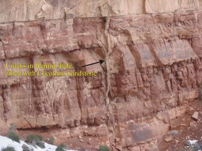
But Baumgardner did not describe the contact as "knife-edge tight" Note the lack of erosional channeling along this contact. The lack of erosional channeling is what characterizes a knife-edge tight contact. Just to be clear about how you're defining knife-edge tight, can I assume that you're no longer claiming that it means a lack of gaps? I still don't know what it does mean, but it doesn't mean that, right? I'm still not sure what you mean by "knife-edge tight," but "lack of erosional channeling" seems an unlikely definition. since many strata boundaries that you don't consider "knife-edge tight" also lack erosional channeling. For convenience, here's the link to the Baumgardner article again: Noah’s Flood: The Key to Correct Interpretation of Earth History. Could you please clarify what you mean by "knife-edge tight"? It appears that when Baumgardner described the lack of erosional channeling that he was implying that the entire Coconino/Hermit boundary lacks erosional channeling. This is not true. There is a great deal of erosional channeling in this boundary, and he tacitly concedes there must be at least some erosional channeling when in the text he asks, "Why is there so little erosional channeling at formation boundaries?" Even more, here's evidence of tectonic pressure where Coconino sand has poured into a crack in the Hermit Shale:
Here's another view of the same crack that is labeled pretty well:
Note that the crack does not extend up into the Coconino. This means that first the Hermit Shale was deposited, then it was deeply buried and lithified, then it was uplifted and the overlying layers were eroded away exposing the Hermit Shale itself to erosion which is when any erosional channeling might have occurred, then the region subsided and became one of net sedimentation and the Coconino was deposited atop the Hermit Shale representing a discontinuity, and finally the crack formed in the Hermit Shale and loose Coconino sand poured in.
I don't know where I got the term ["knife-edge tight"], but the presence of some erosion in a contact is the usual thing,... This is the first time I've seen you concede that erosion occurs at strata boundaries. When did you change your mind, and why? How do you see erosion, a land-based phenomenon, occurring beneath a flood and before the sediments had lithified?
...which is what makes this one special. Again, there is nothing special about a 20 foot stretch of strata boundary with an absence of erosional channeling. It would be just as weird to call a 20 foot stretch of road special because it had no potholes.
The film I posted in Message 1140 calls all Steno's principles into question so I'm not going to spend much more time defending them. I think if you take a peak at that webpage (Critique of Guy Berthault's "Stratigraphy") you'll see you might be treating Steno a bit too harshly. We understand things now at a much better level of detail than Steno, but at a general level his principles hold up pretty well.
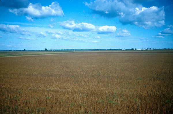
Your plains and deserts simply are NOT as straight and flat and level as any strata anywhere. It's a ludicrous claim. How so? Here are those images again:
How these layers not just as flat and straight as the strata boundary in this following image, which is only about a twenty foot stretch at most:
I'm not comparing knife-edge to straight and level. A lot of the strata in the Grand Canyon are straight and level but as far as I know it's only that one short section of the Coconino-Hermit contact that is knife-edge tight. This still doesn't define what you mean by "knife-edge tight." What is it about the image that says "knife-edge tight" to you where other boundaries between strata are not. As I said, it's at the end of an easily accessible trail (the Bright Angel Trail, one of the most popular at the Grand Canyon, I walked about 3 miles down it with the kids some years back), so it gets photographed a lot. There doesn't seem to be anything unique about it. The boundary between most strata at the Grand Canyon are just as knife-edge tight. Maybe what makes this particular boundary look unique to you is how clearly it stands out because, by chance, erosion has exposed a flat wall that allows the boundary to stand out in stark relief. What is unique is how flat this wall of exposed rock is, not the Coconino/Hermit boundary.
Most of the contacts have some small amount of erosion in them. The Cocnino/Hermit boundary is a discontinuity representing millions of years of erosion of the Hermit Shale and whatever now-lost layers were above it.
Yes of course there are straight strata elsewhere in the world, duh. But there is nothing like the extent of them found exposed in the Grand Canyon that makes it such a treasure. The extent of exposure of buried sedimentary layers is what is unique about the Grand Canyon. The layers themselves are not particularly remarkable, neither in composition nor configuration. Here's another image of straight and flat layers, this one of the cliffs at Bridport on the southern coast of England:
haven't said anything about the erosion of the walls at all, but it's interesting that you know it occurs at a rate of 1.6 feet per thousand years. See Web-based Interactive Landform Simulation Model -- Grand Canyon (WILSIM-GC) Parameters.
Paul Garner of the British Creationist Society made an issue of the tight contact between the Coconino and the Hermit as something special which I took to mean unique. This is in the video of his lecture on the Grand Canyon. It starts at 57:40 and goes to 59 something.
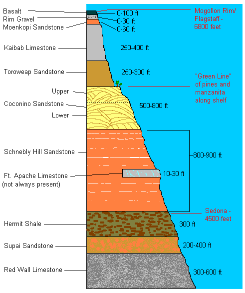
What Garner actually says is that at this location there's a very narrow layer (maybe an inch?) atop the Hermit Shale and beneath the Coconino called the Schnebly Formation. That's actually pretty interesting. I'd never heard of the Schnebly Formation before, so I looked it up. It's much, much thicker at other locations, such as Sedona about a hundred miles south of the Grand Canyon, where it's nearly a thousand feet thick. Here's a diagram of the layers exposed in Sedona at the Mogollon Rim:
--Percy
|
|||||||||||||||||||||||||||||||||||
Faith  Suspended Member (Idle past 1474 days)  Posts: 35298 From: Nevada, USA Joined: |
You do seem to make what to me is a small point into a huge problem and it just seems endless and impossible to find a way to explain something clearly to you. The contact as shown in that picture with the arrow is just one single line with no gaps, no erosion, just a single fine line. As I've said, there only seems to be that one short stretch where it is that tight. That's all I know.
In the video Garner says there isn't even a smidgen of erosion or anything else in that contact.
What Garner actually says is that at this location there's a very narrow layer (maybe an inch?) atop the Hermit Shale and beneath the Coconino called the Schnebly Formation. No he doesn't say that, Percy, please listen again. What he says is that in other parts of Arizona a very THICK layer called the Schnebly formation is found between the Coconino and the Hermit, which leads geologists to figure that there's about ten million years missing between the Coconino and the Hermit in the Grand Canyon although there is no evidence whatever of any deposition at all in the photo in question.
That's actually pretty interesting. I'd never heard of the Schnebly Formation before, so I looked it up. It's much, much thicker at other locations, such as Sedona about a hundred miles south of the Grand Canyon, where it's nearly a thousand feet thick. Here's a diagram of the layers exposed in Sedona at the Mogollon Rim: Yes, the Schnebly is NOT in the Grand Canyon, it is found elsewhere in Arizona. That's what Garner says. Please listen again. ABE: You persist in claiming that your fields and plains and deserts are as straight and level as that contact? I don't get it. If the surface of the Hermit was exposed at that contact so you could walk on it, it would be like walking on a concrete sidewalk. If you walked on the surface in any of your photos you'd strain your ankles because of the clods in the field and the similar unevenness of the other surfaces. I really don't get at all how you can make any comparison between these things. Edited by Faith, : No reason given. Edited by Faith, : No reason given. Edited by Faith, : No reason given. Edited by Faith, : No reason given.
|
|||||||||||||||||||||||||||||||||||
|
Percy Member Posts: 22504 From: New Hampshire Joined: Member Rating: 4.9 |
Faith writes: Yes I find the evidence-based picking of nits to be tedious. Here are the "nits" from my last couple messages that you're ignoring:
--Percy
|
|||||||||||||||||||||||||||||||||||
|
Percy Member Posts: 22504 From: New Hampshire Joined: Member Rating: 4.9 |
Faith writes: I don't know how many times someone or other here has said something like "floods don't make strata,"... It would be approximately zero times that anyone here has said something like "floods don't make strata." What has been stated is that a single global flood could not lay down the sequence of strata found in the geological record. Often people have provided many detailed reasons why this is not possible.
...and I've mostly objected to the idea that the worldwide Flood would be like any local flood,... Since 3/4 of the globe is currently covered by water, how is a truly global flood that covers the remaining quarter much different?
...but it turns out that local floods DO make strata. This is almost true. A local flood can deposit a layer, a stratum. It cannot deposit a sequence of strata. Certainly heavier sediments will settle out before finer ones, but that's gradation, not a sequence of strata.
This information is given in the film I posted in Message 1140 but since many of you may not have watched it, here's some information about the Bijou Creek flood I tracked down:
Abstract of an article in the Journal of Sedimentary Research: Your excerpt does not describe a flood depositing separate strata. It describes a flood depositing sediments that settled out heaviest first (at the bottom) and lightest last (at the top). The different types of deposits it describes were not one atop another like strata but in different locations.
Here's that film again for pictures of the strata starting about 1:04 on the counter.
Did you know there's a YouTube dBCode? Read all about it: YouTube dBCode (Just as a reminder, this is the film that proves all Steno's principles are wrong, confirms Walther's Law and shows that the fossil order is wrong, that younger fossils may be deposited beneath older ones. It shows flume experiments in which sediments deposit simultaneously both vertically and laterally in a current.) You should bring some of the evidence and argument from the film into the thread, or at least provide the time where each issue is addressed. I'd be especially interested in how Walther's Law is confirmed and how the fossil order is wrong. Bertault has been discussed here before. Floods do not behave like flumes. If you'd like to discuss Bertault then you should propose a thread. If you don't want to discuss Bertault then it makes no sense to mention him again. --Percy
|
|||||||||||||||||||||||||||||||||||
|
Faith Suspended Member (Idle past 1474 days) Posts: 35298 From: Nevada, USA Joined: |
The thought of trying to explain any of that to you gives me a stomach ache because if you don't get it by now I know I'm in for post after post of not being able to get you to see any of it no matter what I say.
I think the Kaibab uplift is the linch pin as it were of all the tectonic disturbance in the entire area as shown on that cross section. I think there was a big tectonic event that pushed up the Supergroup which pushed up the Paleozoic strata which caused cracks in the uppermost layers of the mile or two stack of layers above the Permian/Kaibab which then broke up and widened the cracks, which became the Grand Canyon. The same tectonic event raised the southern end of the Grand Staircase up toward the top of the Kaibab uplift where the canyon was formed, and that lifting disturbed the strata in that area which broke off and formed the cliffs of the staircase. That same tectonic event triggered the volcano which sent the magma dike up from the basement through the strata to the top of the Grand Staircase at the very end and no doubt contributed to the general shaking that broke up the strata that made the cliffs of the staircase. The Hurricane Fault occurred at the same time. A lot of shaking going on in that whole area all at once. I also figure the granite was formed at the same time, and the Vishnu schist. This much I had in mind for years now. I spent a lot of time trying to decide where all this was occurring in relation to the Flood, figuring it had to be receding about that time and being the major force that washed away the strata in the staircase area leaving the cliffs, and in the canyon area washing down all those upper strata which carved out that huge space. Recently I started thinking that this tectonic event must have been the big one that split the continents and started the continental drift, which in the Flood scenario would have started out a lot faster than the usual idea of its speed, and gradually slowed over the last 4500 years to its present speed of I think less than an inch a year? Then it seemed that had to be when the Flood waters began to recede after sitting quietly at their height for two months. Something happened on the sea floor and under the contents that broke them apart and caused the water to drain, began the Atlantic ridge, began volcanism which gets triggered with the movement of the continents and so on. Obviously I don't accept much of the conventional thinking about all these things. I've many times tried to answer many of the questions you list. I'm not up to repeating myself about all that. Edited by Faith, : No reason given.
|
|||||||||||||||||||||||||||||||||||
|
Faith Suspended Member (Idle past 1474 days) Posts: 35298 From: Nevada, USA Joined: |
You should bring some of the evidence and argument from the film into the thread, or at least provide the time where each issue is addressed. I'd be especially interested in how Walther's Law is confirmed and how the fossil order is wrong. I indicated where many of these things were presented in the film in Message 1140
|
|||||||||||||||||||||||||||||||||||
|
Percy Member Posts: 22504 From: New Hampshire Joined: Member Rating: 4.9 |
Faith writes: Look at the parts of the video I mentioned in Message 1140, the experiments speak for themselves, I don't need to know anything else about Berthault. Is it really necessary to point out the inadvisability of uncritically accepting a point of view while rejecting the commentary of peer review?
Look, I never have the intention of starting these long off-topic discussions, I merely post an objection to something in the thread and off we go with me usually trying and failing to get off the runaway train. Since I don't start out with any interest in such a lengthy discussion, which usually proves intensely frustrating and boring for me, you or someone else should propose a separate thread. I don't want to do it because that would mean committing myself to this annoying experience I want to end. I think we all have to wonder in amazement at your proclivity for introducing topics you find "intensely frustrating and boring," and that you continue subjecting yourself to "this annoying experience I want to end." If you find this all so disagreeable, why are you here? --Percy
|
|||||||||||||||||||||||||||||||||||
|
Faith Suspended Member (Idle past 1474 days) Posts: 35298 From: Nevada, USA Joined: |
Why am I here?
It gives me an opportunity to figure out what I think that I don't find elsewhere.
|
|||||||||||||||||||||||||||||||||||
|
JonF Member (Idle past 198 days) Posts: 6174 Joined: |
Berthault's experiments were in flumes in which the distance between the walls was small enough to have a significant effect. There is good reason to question their applicability to open water.
|
|||||||||||||||||||||||||||||||||||
|
Percy Member Posts: 22504 From: New Hampshire Joined: Member Rating: 4.9 |
You posted two replies to my Message 1192, I'll respond to both of them here.
Replying to your Message 1193:
Faith in Message 1193 writes: So at that rate for 17 million years, by now there should be a dead space of 10 miles (average) the whole length of the canyon where all the walls had eroded flat, been reduced to dust and rubble as it were. Why don't we see that? "Dead space"? Does that term have some special meaning for you, or are you just referring to the canyon? If you're referring to the canyon then the proper term for the space between the canyon walls is the canyon, not "dead space." The erosion of canyon walls is both a gradual and episodic affair driven by rain, wind, freeze/thaw cycles, shelf collapse, impact of rock falling from above, animal activities, vegetation, and probably other things I don't even know about. The Grand Canyon walls look pretty much exactly like what we would expect them to look like. The larger products of erosion are very visible all along the Grand Canyon in the form of talus or scree. Here's an image of scree from somewhere in the canyon:
Replying to your Message 1195:
The river averages about 300 feet wide in the canyon, so the Grand Canyon should be about 314.4 feet wide. Sounds like it's about exactly what it should be then for an age of 4500 years, but that would depend on how wide the canyon was when the river began. Of course I believe the receding Flood waters cut the canyon to a great width... If the canyon had been cut suddenly then the canyon walls would be vertical instead of sloped.
...and that the river is just what is left of that massive flow,... The river is not "just what is left of that massive flow." I think what you meant to say is that the river follows the course created by the flood.
...and that most of the erosion since the river shrank is from weathering. This would be incorrect. See the description above of the contributions to erosion.
As for vertical sides wouldn't that depend on the amount and force of the receding Flood? The slope of the sides of a canyon are a direct function of how long it took the canyon to form. Canyons formed suddenly in geologic terms, say in less than a thousand years, will have vertical sides. Canyons formed over millions of years will have sloping sides.
Don't the walls of the meanders slope back? Yes, since they formed over very long periods of time, of course the walls of the meanders slope.
In any case all the canyon walls would have sloped back from erosion in 4500 years I would assume. They wouldn't have sloped back. It requires gradual downcutting into a landscape over long time periods to create sloping sides. In 4500 years the vertical sides of your flood-created canyon would be eroded back by around 14.4 feet. Since the canyon walls were already at their current height 4500 years ago, and since those walls were vertical, and since all the canyon walls from top to bottom would have been exposed to the forces of erosion and weathering during all of that 4500 years, the walls would still be vertical. The canyon walls would have eroded unevenly since some layers are much softer than others. For example, a limestone layer would erode much faster than a quartzite sandstone layer, and if the limestone layer was just beneath the sandstone layer then as the limestone layer eroded and removed support for the overlying sandstone layer, chunks of the sandstone layer would begin to break off and fall into the canyon. --Percy
|
|||||||||||||||||||||||||||||||||||
|
Percy Member Posts: 22504 From: New Hampshire Joined: Member Rating: 4.9 |
Minnemooseus writes: There is no info presented about how this slope retreat rate is calculated. See Web-based Interactive Landform Simulation Model -- Grand Canyon (WILSIM-GC) Parameters, also referenced in my Message 1171. It references an estimate of the average slope retreat based upon studies of animal droppings. There are other estimates, but they tend to be complicated because they pose variable rates of slope retreat as a function of time period and position along the canyon, e.g., Rates of river incision and scarp retreat in eastern and central Grand Canyon over the past half million years: Evidence for passage of a transient knickzone. --Percy
|
|||||||||||||||||||||||||||||||||||
|
edge Member (Idle past 1736 days)  Posts: 4696 From: Colorado, USA Joined: |
A couple of points...
The Cocnino/Hermit boundary is a discontinuity representing millions of years of erosion of the Hermit Shale and whatever now-lost layers were above it.
I really don't think it was that long and probably very little was lost. Sometimes people get the wrong idea about ages. For example here is what Durango Bill says about the Coconino and Hermit formations:
Coconino Sandstone - This layer averages about 260 million years old and is composed of pure quartz sand, which are basically petrified sand dunes. Wedge-shaped cross bedding can be seen where traverse-type dunes have been petrified. The color of this layer ranges from white to cream colored. No skeletal fossils have yet to be found but numerous invertebrate tracks and fossilized burrows do exist.
Note that Bill says the formations average 260 and 265 million years old. Words mean something, and here the word 'average' is a very careful usage. No one should take these ages to mean that there is a 5 million year gap at this contact. Hermit Shale - This layer averages about 265 million years old and is composed of soft, easily eroded shales which have formed a slope. As the shales erode they undermine the layers sandstone and limestone layers above which causes huge blocks to fall off and into the lower reaches of the Canyon. Many of these blocks end up in the side drainages and down on the Tonto Platform. The color of this layer is a deep, rust-colored red. Fossils to be found in this layer consist of ferns, conifers and other plants, as well as some fossilized tracks of reptiles and amphibians. http://www.bobspixels.com/kaibab.org/geology/gc_layer.htm#hs Further, it is thought that the cracks in the Hermit are actually mud cracks that were open when the Coconino sand began blowing across the drying mudflats. In many cases the cracks can be seen zig-zagging downward into the Hermit suggesting that there is compaction of the muds as it was loaded by the overlying sand mass or even later as the sediments piled up. My interpretation is that the mudflat was uplfted ever so slightly as the sands slowly and gently loaded the mud. As to the Schnebly Formation. What Garner is actually saying (though he doesn't know it) is that the Schnebly is chronologically equivalent to the Hermit and probably part of the Coconino as well. This, again, is an outgrowth of Walther's Law. Finally, I have been trying to find out if anyone thinks that the Coconino/Hermit contact is an unconformity and I don't really see it discussed as such. If you have such information, I'd be interested in seeing it. I might call it a diastem, but I don't think it is a full-blown unconformity. Edited by edge, : No reason given.
|
|||||||||||||||||||||||||||||||||||
|
edge Member (Idle past 1736 days) Posts: 4696 From: Colorado, USA Joined: |
Does Berthault actually demonstrate anything more than deposition on a slope (which you vehemently denied), Walther’s law and hydrodynamic sorting ? All of which your opponents already accept ?
All Berthault has done is to demonstrate things that geologists have known about for a hundred years. The problem is that he has put it in the context of some refutation of mainstream science. And it isn't. That is why I call Berthault a charlatan.
|
|||||||||||||||||||||||||||||||||||
|
Percy Member Posts: 22504 From: New Hampshire Joined: Member Rating: 4.9 |
Faith writes: You do seem to make what to me is a small point into a huge problem and it just seems endless and impossible to find a way to explain something clearly to you. No one else accepts your explanations either.
The contact as shown in that picture with the arrow is just one single line with no gaps, no erosion, just a single fine line. As I've said, there only seems to be that one short stretch where it is that tight. That's all I know. In the video Garner says there isn't even a smidgen of erosion or anything else in that contact. Geologists look at the Coconino/Hermit boundary and say its a disconformity. That means the top of the Hermit is eroded. The short 20-foot stretch contains no erosion channels, but other sections of the boundary do.
What Garner actually says is that at this location there's a very narrow layer (maybe an inch?) atop the Hermit Shale and beneath the Coconino called the Schnebly Formation. No he doesn't say that, Percy, please listen again. You're right, he doesn't say that. There are apparently no Schnebly Formation represented in the Grand Canyon, not even the inch I thought I saw in this image:
See that skinny layer at the top of the Hermit and bottom of the Coconino? It doesn't look like it belongs to either layer. I wonder what it is.
What he says is that in other parts of Arizona a very THICK layer called the Schnebly formation is found between the Coconino and the Hermit, which leads geologists to figure that there's about ten million years missing between the Coconino and the Hermit in the Grand Canyon although there is no evidence whatever of any deposition at all in the photo in question. Right. I didn't listen that far the first time, I listened for a full minute this time. I don't like videos because I read far faster than people talk.
ABE: You persist in claiming that your fields and plains and deserts are as straight and level as that contact? I don't get it. If the surface of the Hermit was exposed at that contact so you could walk on it, it would be like walking on a concrete sidewalk. Sure, of course - it's rock.
If you walked on the surface in any of your photos you'd strain your ankles because of the clods in the field and the similar unevenness of the other surfaces. I really don't get at all how you can make any comparison between these things. You're inventing things again. People have little trouble walking across flat landscapes. But any minor unevenness is irrelevant because I wasn't comparing those landscapes to the Hermit Shale. You claimed that erosion makes landscapes uneven, and those images show that erosion flattens and evens a landscape. You ignored most of the issues I raised, namely:
--Percy
|
|||||||||||||||||||||||||||||||||||
|
|
Do Nothing Button
Copyright 2001-2023 by EvC Forum, All Rights Reserved
![]() ™ Version 4.2
™ Version 4.2
Innovative software from Qwixotic © 2024