|

Understanding through Discussion |
|
|
Register | Sign In |
|
QuickSearch
| EvC Forum active members: 65 (9164 total) |
|
| |
| ChatGPT | |
| Total: 916,918 Year: 4,175/9,624 Month: 1,046/974 Week: 5/368 Day: 5/11 Hour: 0/2 |
Summations Only | Thread ▼ Details |
|
Thread Info
|
|
|
| Author | Topic: Evolution. We Have The Fossils. We Win. | |||||||||||||||||||||||||||||||||||||||||||
|
edge Member (Idle past 1737 days)  Posts: 4696 From: Colorado, USA Joined:
|
Oh I've always thought The Wave had to be formed by the Flood, it's such a fluid-looking thing.
Air is very fluid.
But my argument is about the strata, period.
The Navajo Formation would constitute strata in anyone's estimation but yours evidently. By the way, I have seen the Navajo and Kayenta contact and it is gradational. Edited by edge, : No reason given.
|
|||||||||||||||||||||||||||||||||||||||||||
Faith  Suspended Member (Idle past 1475 days)  Posts: 35298 From: Nevada, USA Joined: |
Air is very fluid. So are words, obviously. In any case, The Wave does not look like windblown dunes even if the crossbeds have the angle that you associate with them.
The Navajo Formation would constitute strata in anyone's estimation but yours evidently. The Wave? Well, deformed strata then, but I'm talking consistently about strata as originally deposited flat, before any kind of deformation occurred.
By the way, I have seen the Navajo and Kayenta contact and it is gradational. Well, the extremely tight Coconino-Hermit contact I showed is rare and I gather it may not even continue beyond the section pictured. However I'm not sure what you mean by "gradational," perhaps you could show a picture of it?
|
|||||||||||||||||||||||||||||||||||||||||||
|
Faith Suspended Member (Idle past 1475 days) Posts: 35298 From: Nevada, USA Joined: |
I don't suppose you'd consider that these outcrops are erosional remnants of a much larger formation. Isn't an outcrop the exposed part of a formation that is mostly buried, or do I have that wrong? These LOOK like lumps of sandstone that were just plopped down on the visible surface in a wet condition, but I could be wrong, so sure, I can consider your interpretation. Edited by Faith, : No reason given. Edited by Faith, : No reason given.
|
|||||||||||||||||||||||||||||||||||||||||||
|
Faith Suspended Member (Idle past 1475 days) Posts: 35298 From: Nevada, USA Joined: |
By the way, edge, you haven't commented on the timing of the erosion of the hoodoos, monuments and Grand Canyon that I brought up in Message 1074. How do geologists compute the timing?
|
|||||||||||||||||||||||||||||||||||||||||||
|
PaulK Member Posts: 17828 Joined: Member Rating: 2.5 |
quote: I didn’t. What I said is that I think the figure of 2-4 feet refers to the loss of height. That doesn’t mean that I think no other erosion is going on, just that we don’t have the figures for it.
quote: Why? You say you did the calculations, let’s see them.
|
|||||||||||||||||||||||||||||||||||||||||||
|
Faith Suspended Member (Idle past 1475 days) Posts: 35298 From: Nevada, USA Joined: |
You must be right that it refers to height. I was thinking volume but that wouldn't be expressed in feet. At the rate of two to four feet per hundred years, the tallest one, which is 150 feet tall, according to this site, would disintegrate in 7500 years at two feet per century, and half that at four feet (If I'm wrong, please correct me).
But that article also says Thirty to forty million years ago this rock was "born" in an ancient lake that covered a great deal of western Utah. In that length of time a lot of hoodoos should have bit the dust as it were but I don't know how to calculate how many since there's no information about how many there are or were. It depends on how many potential hoodoos there are yet to be eroded and how long each takes how long it would take to reduce the entire formation to dust {see diagram of how they are formed at the link above}. I'm really not up to the calculations but it seems to me that if the limestone was deposited there thirty to forty million years ago there shouldn't be any left there at all, or maybe a straggly few. I think none, and none already long before that. But it's a guess. Edited by Faith, : No reason given.
|
|||||||||||||||||||||||||||||||||||||||||||
|
PaulK Member Posts: 17828 Joined: Member Rating: 2.5
|
quote: The numbers look right to me.
quote: The mistake is rather obvious. You need the time from when the rock was exposed and started to be eroded, not the time when the original sediment was deposited. We can say that it is very likely to be much less than 40 million years, but it needs to be worked out from the geological history of the site. The time when the sediment was deposited isn’t even much help in working it out.
|
|||||||||||||||||||||||||||||||||||||||||||
|
jar Member (Idle past 425 days)  Posts: 34026 From: Texas!! Joined: |
And that when first exposed there were NO hoodoos just a relatively flat plain. The hoodoos were created by the weathering and erosion of all of the millions of tons of material that was between them.
|
|||||||||||||||||||||||||||||||||||||||||||
|
jar Member (Idle past 425 days) Posts: 34026 From: Texas!! Joined: |
Please present a valid and evidenced explanation of how your flud could create the following.
Cross-bedding of sandstone near Mt. Carmel road, Zion Canyon, in Utah USA, indicating wind action and sand dune formation had occurred prior to formation of the rock.
Cross-bedding Of Sandstone Near Mt Carmel Road Zion Canyon Utah [CC BY 2.0 (Creative Commons — Attribution 2.0 Generic — CC BY 2.0 ) or Public domain], by Dr. Igor Smolyar, NOAA/NESDIS/NODC. (NOAA Photo Library: amer0038), from Wikimedia Commons[/center]
Edited by jar, : fix image Edited by jar, : fix first image Edited by jar, : fix second image Edited by jar, : fix fourth image Edited by jar, : fix last image
|
|||||||||||||||||||||||||||||||||||||||||||
|
Percy Member  Posts: 22506 From: New Hampshire Joined: Member Rating: 5.4 |
Faith writes: Nobody said the contact is "flat and level" EVERYWHERE (I actually said knife-edge tight). All contact between all layers of all geological strata are "knife-edge tight." The great pressure of overlying strata eliminates all empty space and guarantees that there can be no gaps where one could insert a knife-edge. Though Tanypteryx implies you said "flat and level", what you actually said was "straight and flat". "Flat" is one way you often describe strata, and you often cite Steno's rule of original horizontality, which implies level, so Tanypteryx's interpretation seems pretty much on the mark. And Steno was also pretty much on the mark, but he came before the understanding accompanying Walther's Law where transgressions/regressions of a sea across a non-level landscape that rises with distance from the coastline pretty much guarantees that in such cases horizontality is impossible. The Grand Canyon region is a good example since its layers were formed by transgressions/regressions of a local sea, and the thicknesses of these layers varies greatly across the region. Layers of inconstant thickness can at most be originally horizontal on only one of their two surfaces, and in most cases neither surface was ever precisely horizontal. Erosion tends to level and flatten a landscape, so we should expect to find flat and level contacts at unconformities such as that at the top of the Hermit Shale (ignoring any sloping caused by the Kaibab Uplift), but not exclusively. As HereBeDragons mentions, the transgressions and regressions of the sea upon the land were episodic affairs that created regions of extreme non-flatness and non-levelness. His image doesn't include the Hermit Shale and Coconino levels, but you get the idea:
It's remarkable that even a short stretch of it still survives after thousands of years. Why would it be remarkable for deeply buried geological strata to survive millions and billions of years? Rock that is completely protected from the elements would not be expected to change at all.
That's the beauty of the Grand Canyon, huge areas of strata are preserved... The Grand Canyon is not preserving strata but exposing them to the elements. That is, the Grand Canyon is destroying strata, not preserving them. The average rate of slope retreat in the Grand Canyon is around a half meter per thousand years. I think what you probably meant to say is that the Grand Canyon is exposing huge areas of strata making it possible for us to closely examine them.
...as close to their original flat and straight horizontality as possible after thousands of years (after millions we'd be lucky to have a pile of dust left),... What forces or processes are you imagining could turn buried geological strata to dust?
...while strata elsewhere are usually so tectonically deformed its hard to analyze them. Complex sequences of tectonic forces have of course occurred in some parts of the world, usually near tectonic plate boundaries. The Grand Canyon is in the middle of the continent, very, very far from the nearest tectonic plate boundary.
Just a very short stretch of such a close contact kills the Old Earth nonsense. Again, the enormous overlying pressure of geologic strata completely rules out any possibility of gaps between strata. By necessity all contact between geological strata is close contact, or as you like to say, "knife-edge tight."
Hundreds of flaws eh? Most of them are irrelevant, some of them are just artifacts of OE theory and totally irrelevant, and besides, once it's been shown that there are ineradicable features that point to a young earth all the little "flaws" really don't amount to much. I explained at great length the most significant flaws in your thinking in Message 1016. You ignored almost the entire message, responding with a single short paragraph containing only bald declaration. Others have of course also explained the flaws in your thinking, and ultimately you ignore them in a variety of ways, such as by not replying, or replying to only a small portion, or by just redeclaring your position, or by engaging in ridicule, or by expressing incredulity, or by expressing anger, or by abandoning the thread, etc.
My scenario accounts for a lot of evidence. As explained, your scenario doesn't reflect much if any knowledge of geological processes, seems to misunderstand a great deal, and ignores a great deal more.
There is no principle of geology that says regions of strata cannot remain intact and undisturbed for millions of years, It's utterly wacko to make such a claim. Is "wacko" a technical term for you?
Who needs a "principle?" In other words, you have no reason for your belief that strata cannot remain intact and undisturbed for millions of years.
It is tacitly assumed in Geology that there must have been a lot of disturbance over hundreds of millions of years. Yes, of course there have been many "disturbances" over hundreds of millions of years. The evidence of things like sedimentation, erosion, uplift, subsidence, transgression, regression, etc., is in the strata. Regarding tectonic activity, the Grand Canyon region must have experienced dramatic mountain building over a billion years ago, reflected in the tilted Supergroup. The region around Cedar Breaks experienced a period of mountain building sometime in the past one or two hundred million years, reflected in the dramatic tilt of the Paleozoic layers. The Grand Canyon region experienced the relatively mild Kaibab Uplift over the past 70 million years. Other parts of the world dramatically reflect many periods of great tectonic activity.
For such a total absence of disturbance to be the case ought to destroy Old Earthism all by itself. The total absence of tectonic events in some region over some lengthy time period would only indicate a tectonically quiet period, not destory Old Earthism. Your reasoning makes no sense.
We point out that they are not all level, or flat, or undisturbed, but you brush aside that, because that isn't what you want to focus on All the disturbances occurred in RECENT TIME, within a few thousand years, not hundreds of millions. I've shown that over and over. As pointed out above, everything you've claimed about geological evidence and processes has been rebutted, and you have never provided answers for the rebuttals.
It supposedly took hundreds of millions of years to lay down totally undisturbed strata and then all at once great disturbances happen, all at once, whammo, and a huge canyon is cut through them along with the cliffs of the Great Staircasse and the whole upheaval below the Great Unconfirmity. You can't possibly be thinking about the implications of this. That "disturbances happen, all at once, whammo" is your Flood view, not the view of geologists. If by "disturbances" you're referring to tectonic events, then the familiar diagram reflects a number of them. On the right we have the tectonic uplift of the Supergroup well over a billion years ago that by the tilt must have been a mountain building event. I guess the erosion of the Supergroup down to nubs over a hundred million years could be considered another disturbance. To the left we have the extreme uplift of the Cedar Breaks region around a couple hundred millions years ago that must have resulted in mountains that are also no longer there, eroded away. And in the broad middle we have the Kaibab uplift, maybe seventy million years ago. In the view of geology there was never any "all at once, whammo" in the major geological features of the Grand Staircase region. For convenience, here's the familiar image again:
but it turns out that your claims of non-disturbance or no erosion between layers are refuted by the evidence that can be seen by people who go out and look at actual rock layers. This is not true. It's quite plain on the cross section and in many photos that all the disturbance happened after all the strata were laid down flat and straight. There is nothing to prevent "disturbances" (I'm going to assume you're speaking tectonically) during strata deposition. Tectonic uplift and subsidence are one of the primary causes of transgression and regression of seas across landscapes. Erosion is a non-tectonic disturbances over millions of years, possibly tens and hundreds of millions. The top of the Hermit Shale represents a period of millions of years of erosion. In order to create sufficient pressure to turn the Hermit Shale to rock there must have been strata of great thickness above it that that were completely eroded away. We'll never know what those layers were, unless we find their eroded remains in other strata, as often happens.
All the twistings and breakings and every kind of deformation happened afterward. No one denies that strata must be deposited before forces of any kind can operate on them. There can be no erosion or tectonic deformation of a strata that doesn't yet exist.
And the so-called erosion between layers is on too tiny a scale to have occurred during any supposed time of exposure at the surface. What leads you to this conclusion? As described earlier, the Hermit Shale must have had a great weight of overlying strata at one time, else there would have been insufficient pressure to turn it to rock. Without great pressure it would have remained unconsolidated sediment.
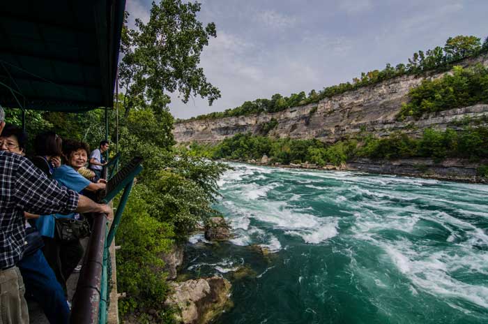
Where are the huge canyons during those time periods? Where are the cliffs and the collapsed formations? There's only one Grand Canyon sized canyon in the entire United States right now, so first realize that "huge canyons" are not a common geological structures. But the real reason canyons are only rarely preserved in the geological record is because they tend to reside in regions of net erosion, as proven by the fact that a river or at least periodic flowing water cut through it. Here's an image of the Niagara Gorge, formed by recession of Niagara Falls. In case you didn't know, the Niagara Falls cuts back through the landscape at the rate of around 0.7 feet per year. It used to be more before they reduced the flow in order to reduce the rate of recession. Anyway, what that means is that since the white man's arrival on these shores, Niagara Falls has cut back through the landscape by around 500 feet. This part of the gorge shown in this image did not exist 500 years ago:
The point is that this is a region of net erosion. There is no net deposition of sediments on this landscape, not in the gorge nor on the land above the gorge. This region will not be preserved in the future geological record. It will eventually be eroded away to nothing. It *could* become preserved in the geological record were the region to experience rapid subsidence beneath the waves, or if sea levels were to suddenly rise, but the Niagara Falls region is around 600 feet above sea level, so that's not likely. The Niagara Falls region is not unique. The Grand Canyon will not be preserved in the geological record because it is at an elevation of around 7000 feet. It is definitely a region of net erosion. Eventually over millions of years all the layers from the Kaibab down to the Supergroup and the Vishnu Schist will be eroded away to tiny particles that find their way to the sea to be deposited as sand and silt and clay and mud.
We're talking millions of years per layer, the amount of "erosion" between layers is laughable in that time frame. Erosion rates vary widely according to local conditions, but if we assume a foot of erosion per thousand years (about .01 inches/year) then in five million years it would amount to one mile. Imagine that, at the incredibly slow rate of just .01 inches/year, in five million years a mile of rock can be eroded away and disappear forever.
The funny thing is the actual strata do not show you anything, the time periods aren't seeable, they are imposed on the strata, conjured up out of bits and pieces of flotsam found in the layer of sediment, like reading tea leaves. I'm the one who actually looked at the strata and saw that it isn't what Geology invented out of it. In the strata geologists find fossils and burrows and tracks and radiometric dates and sedimentation rates and evidence of lengthy and complex periods of transgressions/regressions and buried river channels and buried canyons and so forth. What is it that you think you see in the strata that indicates they were deposited rapidly by a flood? --Percy
|
|||||||||||||||||||||||||||||||||||||||||||
|
Percy Member Posts: 22506 From: New Hampshire Joined: Member Rating: 5.4 |
Faith writes: On the cross section the uplift of the whole canyon area occurred after all the strata were laid down, because they would not lie down over such a rise. Again, here's the image for convenience:
Everyone agrees that the strata were deposited before the uplift, but not for the reason you cite, namely that the sediments "would not lie down over such a rise." You're forgetting that, as in most geologic diagrams, that the vertical dimension is exaggerated. This is more accurate:
Now that we can see more accurate slopes it is obvious that sediments would have no trouble depositing on such a mild rise as the Kaibab Uplift. They didn't, of course, but the rise is so mild that had it been present while the sedimentary layers were being deposited it wouldn't have represented a problem at all.
All the disturbance of the area is shown from the Permian on up and beneath the Tapeats. Near the end of this paragraph you say, "Only one tectonic event is needed for all this to happen," so in your mind the disturbances you describe are all part of one tectonic event. Of course, tectonic motion is very slow, and while it can cause rapidly moving events such as earthquakes, in general processes like uplift, subsidence and tilting are very slow processes that take millions of years. In the minds of geologists the tilting of the Grand Canyon Supergroup layers and the uplift of the region to form the Kaibab Plateau would have taken millions of years. But we know that in your mind everything took place over the course of less than a year, so I'll try to interpret what you say in that context. So by "disturbance" you mean one of the effects of this single tectonic event.
The upper disturbance occurred after all the strata were laid down. That is, the canyon was cut, and the whole Grand Staircase area as well, after the strata were all laid down. From context it appears that by "upper disturbance" you mean all the erosion of the Grand Staircase region, including the Grand Canyon. Only later to do you mention the uplift of the region. How could the region become one of net erosion before the uplift?
The Hurricane Fault occurred afterward,... By "afterward" you mean after the erosion of the region? If so, what information tells you when the Hurricane Fault occurred relative to the erosion, especially since it extends right up to the topmost layer? Why couldn't the Hurricane Fault have occurred after the deposition of the strata but before the uplift of the region began the erosion?
...the magma dike at the north end of the staircase occurred afterward, etc. Again, by "afterward" you mean after the erosion? If so, what information tells you when the magma dike occurred after the erosion? Why couldn't the magma dikes have occurred after the deposition of the strata but before the uplift of the region began the erosion?
I believe the lower disturbance that tilted the Supergroup also occurred afterward... So you believe that the erosion of the region occurred before the tilting of the Supergroup caused the Kaibab Uplift. How could erosion occur before uplift?
...because the Supergroup has to be the obstacle that caused the Paleozoic strata to form that rise over it,... This sounds different from what you've said before. I thought your position was that the tectonic forces that caused the Supergroup to tilt also caused the uplift above the Supergroup? This new position of yours, where the Supergroup somehow serves as an obstacle that causes the Paleozoic strata to form the Kaibab Uplift, seems equally impossible. Except for an island of hard Shinumo Quartzite extending up into the Tapeats, the entire Supergroup precisely matches the contours of the above layers. And what happened to your claim at the top of your message that, "the uplift of the whole canyon area occurred after all the strata were laid down, because they would not lie down over such a rise." How come a couple paragraphs ago sediments would not "lie down over such a rise," but now the Supergroup were an obstacle "that caused the Paleozoic strata to form that rise over it,..."
...being pushed up into it after the strata were all there. If the Supergroup was the "obstacle that caused the Paleozoic strata to form that rise over it, then why does it later have to be pushed up into the Paleozoic strata? And there's that same problem of the Supergroup unconformity precisely following the contours of the Paleozoic strata - it doesn't appear to have been pushed up into the Paleozoic layers at all. And if it were the Supergroup layers pushing up on the Paleozoic strata that caused the Kaibab Uplift, then what caused the uplift of the Paleozoic layers to the left of the Supergroup?
I've described this many times here and in other threads, but weirdly dwise and others seem to be blind to it Your ideas have been rebutted and shown impossible many times here and in other threads, but weirdly you seem blind to it.
Plus of course the fact that there is no hint of any kind of disturbance to the strata in any earlier "time period" -- no canyons cut, no cliffs formed etc. As explained in a prior message, canyons and cliffs are very unlikely geological structures to be preserved in the geological strata. They're the stuff of upland regions of net erosion. They eventually erode away and disappear forever. It would require rapid subsidence or sea rise or a combination to preserve canyons and cliffs in the geologic record. It seems possible but rare. Maybe Edge can comment.
There's Percy still trying to get a knife-edged contact with a flat and straight surface out of plains and deserts. Where do you see a problem with deep sedimentation upon a flat surface such as a plain (I never said desert in this context) causing a "knife-edged contact"?
Having to strain to pretend rock layers would conform to a wavy surface... Are you still talking about a plain? How is a plain a wavy surface except on a scale of miles? Your image of the contact between the Hermit Shale and the Coconino is only about 20 feet long at most:
On a scale of miles this interface waves all over the place.
...after millions of years ought to be some kind of hint that the conventional view is not exactly open and shut. How could sedimentary deposits not conform to the surface they're deposited on, right at the time they're deposited and not requiring millions of years. The sediments only turn to rock after being buried and subjected to great pressure, which does take millions of years. --Percy
|
|||||||||||||||||||||||||||||||||||||||||||
|
Faith Suspended Member (Idle past 1475 days) Posts: 35298 From: Nevada, USA Joined: |
All contact between all layers of all geological strata are "knife-edge tight." The great pressure of overlying strata eliminates all empty space and guarantees that there can be no gaps where one could insert a knife-edge. No they aren't or there would have been no reason to point it out in that photo. I wasn't objecting to the meaning of what Tanypteryx said, just pointing out my actual words. Why on earth you would make an issue of that is hard to understand. Original horizontality doesn't mean sameness of thickness, just that the overall lie of the layer is horizontal. Even Walther's Law won't make a layer climb up an incline. It would have to rise incrementally by the building up of the deposits.
Erosion tends to level and flatten a landscape, so we should expect to find flat and level contacts at unconformities such as that at the top of the Hermit Shale Your efforts to find an example of such a perfectly flat and level surface have failed miserably. Plains and deserts are nowhere near the knife-edge closeness and straightness of the Coconino-Hermit contact. That contact is presented BECAUSE it is rare or perhaps even unique, so your general statement about such unconformities is false. And I'm sorry but I just don't get the point of all that business about transgressions and regressions, strikes me as irrelevant at best.
It's remarkable that even a short stretch of it still survives after thousands of years. Why would it be remarkable for deeply buried geological strata to survive millions and billions of years? Rock that is completely protected from the elements would not be expected to change at all. It isn't protected from disturbances such as earthquakes and faults and magma intrusions which can unsettle buried rock, and tectonic force can drastically deform it even when buried. But I wasn't speaking theoretically, it was a simple observation that such a tight contact is rare even in an environment like the Grand Canyon where overall horizontality and straightness still exist to the naked eye, when at other locations it's rare to find even that much preserved. It's just an observable fact that the Grand Canyon preserves many features of the original deposition of the strata that are not preserved elsewhere. That's what makes the Grand Canyon especially valuable for this kind of discussion.
The Grand Canyon is not preserving strata but exposing them to the elements. That is, the Grand Canyon is destroying strata, not preserving them. Sure, that's what makes the preservation of what has been preserved there so remarkable. The overall processes are of course destructive, but nevertheless original horizontality, straightness etc. are still clearly apparent. Settling has occurred, erosion has occurred, there are areas where the walls have collapsed, but nevertheless what has been preserved in spite of all that IS remarkable and makes the Grand Canyon especially valuable for geological investigations.
The average rate of slope retreat in the Grand Canyon is around a half meter per thousand years. I think what you probably meant to say is that the Grand Canyon is exposing huge areas of strata making it possible for us to closely examine them. That's probably part of it but it's just my impression is that wherever strata are exposed elsewhere they tend to be distorted in ways that strata in the Grand Canyon are not. It's just a simple observation, Percy, you are making a major deal out of nothing here.
Complex sequences of tectonic forces have of course occurred in some parts of the world, usually near tectonic plate boundaries. The Grand Canyon is in the middle of the continent, very, very far from the nearest tectonic plate boundary. Perhaps that is the reason, but the reason isn't relevant since this is just a simple observation of fact.
...as close to their original flat and straight horizontality as possible after thousands of years (after millions we'd be lucky to have a pile of dust left),... What forces or processes are you imagining could turn buried geological strata to dust? The GC strata I'm talking about are not buried, they are exposed, and they are being eroded and producing piles of eroded matter at the base of every formation. But in my opinion nowhere near enough erosion as should have occurred in the millions of years the canyon has been there, seventeen million or five million or whatever. In my opinion the amount of erosion is about right for the 4500 years since the Flood but way too little for millions of years as the Old Earth theory has it. That's my assessment of what I actually see. Wherever strata have been exposed for even more millions of years I'd expect it all to be reduced to rubble and dust, and even five million years might be enough for that to occur. The slope retreat you describe above is the only "force" I have in mind, all due to regular erosion from the exposed walls of the canyon.
Again, the enormous overlying pressure of geologic strata completely rules out any possibility of gaps between strata. By necessity all contact between geological strata is close contact, or as you like to say, "knife-edge tight." But that is not what is observed, Percy, which is why that particular short sequence of Coconino-Hermit contact is of enough importance to be pointed out. And others have argued that even that much knife-edge tightness doesn't occur, so there's the proof of it for them. Most of the other contacts are visibly not that tight, have small amounts of erosion and so on. Answering this long post is tiring, I'm going to take a break. Edited by Faith, : No reason given. Edited by Faith, : No reason given.
|
|||||||||||||||||||||||||||||||||||||||||||
|
Percy Member Posts: 22506 From: New Hampshire Joined: Member Rating: 5.4
|
Faith writes: Actually most sedimentary layers by their very composition, regardless of extent, argue against the flood, because floods deposit undifferentiated mud. As I've noted many times, the Japan tsunami only deposited a thin layer of mud. It did not pick up a load of sand from the beaches and carry it inland.
The deceit of this comparison is staggering. I don't think there's any deceit going on on either side. Both sides are providing their interpretation of the evidence. One side interprets the evidence according to known physical laws and by projecting geological processes observed taking place today back in time. The other side ignores known physical laws and makes up fantastical scenarios that have no basis in reality.
No local flood makes any kind of model for the worldwide Flood of Noah and this pretense of a comparison is underhanded. Ignoring the "underhanded" part, how is your global flood any different from local floods happening everywhere?
"Floods" may deposit "undifferentiated mud" but an ocean standing over land would deposit layers of sediments. Actually, no, decidedly not. Even you will concede that we know that oceans have existed for at least the thousands of years of human historical records, and the sea floor does not contain layers of sediment that in any way resemble those on land. What we find in deep ocean are pelagic sediments going back millions of years. The rate of sedimentation is approximately 1-5 centimeters/1000-years. If we look at ocean sediments from 4500 years ago there are no hints that the ocean ever contained huge sediment loads of sand, silt, mud, clay and limestone. For your flood scenario to be true would require that every bit of sediment made it to the proper place on land with none of it ending up in the wrong layer, and especially never falling out of suspension in the deep ocean. I posted you a message of over 2000 words and this response barely represents an aside. This is why people say you have no answers for the rebuttals, because though a variety of methods you just don't respond. Every part of every scenario you come up with is wrong, people tell you they're wrong and precisely how they're wrong, then you just ignore and repeat. --Percy
|
|||||||||||||||||||||||||||||||||||||||||||
|
Percy Member Posts: 22506 From: New Hampshire Joined: Member Rating: 5.4
|
Replying to several of your messages to Edge at one time...
Replying to your Message 1024:
Faith in Message 1024 writes: edge writes: Actually, your flood should be worse at depositing clean, even, thick, bedded deposits because it is transporting trillions of tons of material a thousand miles. Yeah I'm sure you can make up all kinds of objections to anything I say, as you always do. You have no idea how long sediment could be carried in the Flood water. If sediments can stay suspended in a lake for many months as I showed some posts back, I see no reason why they couldn't stay suspended in the Flood water. And neither do you really. How is this a response to what Edge said? He wasn't commenting on how long sediments can stay suspended in water. That, as always, is a function of water energy and the size/density of the particles. Sand settles out quickly, even in energetic water on beaches, while silt, mud and clay settle out in quieter water over longer time periods. These land-sourced sediments don't generally get carried too far out to sea in any great amounts, so in warm shallow seas sediments are dominated by calcium carbonate remains of sea life. In deep ocean pelagic sediments are most common, being mostly very fine-grained land-sourced sediments that managed to be carried a great distance. You didn't address Edge's brief comment, which carried with it many implications, such as about how your flood created "knife-edge tight" boundaries between sedimentary layers; about it never mixing up the content of any layer with another in layers separated by unconformities; about it allowing interbedding to occur between layers that are continuous; about it transporting sediments long distances without mixing them up. Replying to your Message 1027:
Faith in Message 1027 writes: The uplift doesn't preclude earlier tectonic events, but the evidence seems to show that all the disturbance top and bottom occurred in the one event beneath the canyon area. But in an earlier post the first disturbance was the erosion of the Kaibab Plateau and the rest of the Grand Staircase region. Erosion isn't caused by tectonic events. In that earlier post you proposed this sequence of disturbances:
Doesn't that pretty much summarize what you said?
The absence of any disturbance to the Paleozoic strata during their laying down,... Why do you believe this is significant? This region is far from any tectonic boundaries. Unlike the Rocky Mountains, this region is pretty quiet tectonically. That being said, I believe in past threads people have identified geologic evidence of tectonic activity during the depositing of the Paleozoic layers. Also, the dating evidence we have says that the tilting of the Grand Canyon Supergroup happened a half billion years before the depositing of the Paleozoic layers, that the uplift of the north end of the Grand Staircase occurred a couple hundred million years before the Kaibab Uplift, and that the Kaibab Uplift happened maybe 70 million years ago. There have been a series of tectontic events at widely separated intervals.
...the fact that the north staircase fault and magma dike occurred after all the strata were laid down, shows activity in the basement rocks at that time. It is bleedingly obvious that they occurred after the strata were deposited, since faults and magma dikes can't occur in strata that don't yet exist.
Tectonic force would cause a lot of disruption in the basement rocks so one would be quite enough. By basement rocks do you mean the Vishnu Schist? If so, then the only evidence of "disruption" (this is a very poorly chosen term, as is "disturbance") of the Vishnu Schist is where the Supergroup was tilted, causing faults that extend down into the the schist. Note that the faults do not extend up into the Paleozoic layers. That's because the Paleozoic layers had not yet been deposited when the Supergroup layers tilted.
Besides I've been suggesting that this was THE tectonic event, the very first one,... There are faults around the world older than those in the Vishnu Schist. For instance, the Paleoproterozoic Capricorn Orogeny in western Australia is very ancient and contains faults more than two billion years old, for instance, the Lyons River Fault.
...the one that split the continents and started them drifting apart,... Even you must recognize the absurdity of a single tectonic event initiating worldwide continental drift.
...not one of the many events when the continents hit a snag and caused an earthquake or opened up a volcano. I don't think anyone, including you, knows what "continents hit a snag" means. Earthquakes are caused by sudden movements along fault lines. Volcanos tend to be, but are not exclusively, associated with plate interfaces.
The worldwide extent of the Great Unconformity reflects that idea,.. The Great Unconformity is not worldwide in extent. Instances of it can be found in different places around the world, such as the Grand Canyon and Siccar Point, but it couldn't possibly be worldwide, otherwise we would have no strata or fossils from 600 million years ago, like the Ediacaran fossils, and no strata or fossils from 800 million years ago, like the Tonian strata and acritarch fossils.
...and it also started the Flood waters draining, probably by something that happened on the ocean floor at that same time. There's no evidence of a global flood 4500 years ago, nor any evidence of a massive drain on the ocean floor, nor any evidence of outlets for the fountains of the deep. You seem to have two modes:
The shaking should have been quite dramatic, good thing the only human beings left were safely floating on the surface of the water about to touch down on land. Did you never wonder why no fishermen were able to save themselves?
And if you agree with me that the uplift is younger... Since you've compressed billions of years of worldwide geologic activity into a period of less than a year, no one is going to agree with you on your impressions of what constitutes something being younger than something else. On geological scales events in the same year are virtually simultaneous. The uplift of the Kaibab Plateau occurred slowly over millions of years, during which the Colorado River gradually cut a channel into the slowly elevating landscape. The tectonic forces responsible for the uplift had nothing to do with the tectonic forces that tilted the Grand Canyon supergroup about a billion years earlier.
...then you really should have to agree with me that along with the evidence mentioned above about the whole canyon area is evidence for a young earth. What "evidence mentioned above"? You do mention things that actually exist, like the Grand Staircase region, tectonic forces, magma dikes, continental drift, basement rocks, the Great Unconformity, etc., but the story you build around them is a fiction supported by no evidence at all. Replying to your Message 1028:
Faith in Message 1028 writes: No, I'm not making stuff up, I've been giving evidence all along. Your entire sequence of events in the Grand Staircase region is made up. There is no evidence for your preferred order of events. Some of the things you think happened are impossible, such as buried layers tilting without affecting overlying layers. Some of the things you believe are absurd, such as that geological strata are no longer forming today, as if somehow sedimentation had been brought to a halt. Surely you don't believe erosion has been brought to a halt, so where do you think the products of erosion are going?
You may think you like not knowing how long and how far the sediment could be carried in the Flood, but it was you who said it couldn't carry it as far as the Flood would require. You quote nothing from Edge's message, so I can't be certain which part this is a reply to, but it seems likely that you missed the obvious sarcasm.
I know we're not talking about a lake but we are talking about how long sediments can stay suspended in a body of water. Seems relevant to me. Of course it's relevant, but you're evading the issue Edge has been trying to get you to face: How does a flood carry sediments thousands of miles across a continent and then separate them by type (not by size or density), deposit them with "knife-edge tight" contacts, include erosional unconformities, sort by fossil type and radiometric age, etc. Replying to your Message 1032:
Faith in Message 1032 writes: edge writes: All I can say is that there is no evidence of a flood of the type you suggest. Oh nonsense and denial. Edge has been asking how a flood can do the things you claim, and you've been working hard at not providing answers. Edge cannot deny answers you haven't' given.
Strata and bazillions of dead things. We all understand that the geology of the Earth includes fossil-bearing strata, so this is not an answer to anything. You posted a second reply to Edge's Message 1030, so moving on to that one... Replying to your Message 1034:
Faith in Message 1034 writes: edge writes: The only evidence you have provided is not diagnostic of your scenario. Several of your points make no sense. There is no evidence of detachment along the Great Unconformity, for instance. You cannot support such a notion. In any paradigm some of its elements must be inferred from the basic model rather than direct evidence. So what is the chain of inference that leads to the conclusion that there is detachment along the Great Unconformity? Replying to your Message 1037:
Faith in Message 1037 writes: Since you just complained that I didn't answer this I'll do it now: People shouldn't have to keep bringing your lack of responsiveness to your attention just to get you to answer simple questions. Edge didn't respond to this message, I can't guess why since he replied to your subsequent messages. Maybe he just missed it.
There is plenty of evidence for earlier deformation, first of the Vishnu Schist and later, the tilting of the GC Supergroup. I read the evidence differently than you do. And how are you reading that evidence?
As far as igneous activity, we have the intrusion of the Zoroaster Granite and the Cardenas basalt at different times and long before regional uplift started. This is one of those inferences from a paradigm I was talking about. Since I find your paradigm wanting I'm not favorable to the inference. This is a non-answer. How does your paradigm interpret "the intrusion of the Zoroaster Granite and the Cardenas basalt at different times and long before regional uplift started?"
On top of that we have evidence of erosion with several disconformities within the Paleozoic section. You don't actually have evidence of erosion at all, you infer it from the fact that there is a layer missing where you expect it to be. But if you look at the actual surface where you expect it to be there is no evidence of erosion except the absence itself, and since the knife-edge tight contact between Coconino and Hermit is that sort of discontinuity the absence of any hint of erosion is rather glaring. The evidence for a disconformity, which is what the boundary between the Coconino and the Hermit really is, is threefold:
The boundary between the Coconino and the Hermit fulfils all these criteria. Coconino is sandstone while the Hermit is siltstone. There is a gap in the era of the fossil types. And the top of the Hermit includes erosional details like paleovalleys (one 60 feet deep) and erosional channels (some 10 feet deep).
In the meantime we have all manner of evidence for tectonism occurring elsewhere in the world while the Colorado Plateau area was relatively quiet. The Appalacians started forming as early as the Ordovician time, for instance, and there is evidence of multiple deformations over a billion years ago on the Canadian shield. But radiometric dating is just not going to fly with me,... If doesn't matter whether it "flies" with you. What matters is whether you have any counters to the evidence, and you don't.
...it's all a bunch of conjectural stuff, not real evidence. I don't think name-calling and denial constitutes rebuttal. As I mentioned before, even the RATE group found no problems with radiometric dating.
I'm sure you misread it all and the tectonism all occurred at the same time everywhere. What evidence are you looking at that leads you to conclude that "the tectonism all occurred at the same time everywhere"?
Unless it's clearly just a local event in which case it has nothing to do with the tectonism in the Colorado Plateau anyway. This is a nonsense objection. Every tectonic event is local to someplace. There was tectonism local to other places in the world at the same time that there was little or no tectonism local to the Grand Canyon region. And vice versa. Your contention that the Grand Canyon region could not reasonably be expected to be relatively tectonically quiet for a sustained period cannot be maintained in the face of the evidence, especially given its distance from tectonic boundaries where tectonism is more common. --Percy
|
|||||||||||||||||||||||||||||||||||||||||||
|
Percy Member Posts: 22506 From: New Hampshire Joined: Member Rating: 5.4 |
ringo writes: Faith writes:
How? Isn't most of the eroded material in the Gulf of California? If it had been formed any number of millions of years ago the eroded material would probably have buried the whole thing by now. At one time yes, the Colorado dumped its sediment load into the Gulf of California, but then they built Hoover Dam, and now the sediment falls out of suspension once it reaches Lake Mead. Because of demands for water by farming and cities the Colorado actually no longer reaches the Gulf of California except during special releases of water. --Percy
|
|||||||||||||||||||||||||||||||||||||||||||
|
|
Do Nothing Button
Copyright 2001-2023 by EvC Forum, All Rights Reserved
![]() ™ Version 4.2
™ Version 4.2
Innovative software from Qwixotic © 2024

 (1)
(1)