|

Understanding through Discussion |
|
|
Register | Sign In |
|
QuickSearch
| Thread ▼ Details |
|
Suspended Member (Idle past 1472 days)  Posts: 35298 From: Nevada, USA Joined: |
|
Thread Info
|
|
|
| Author | Topic: Motley Flood Thread (formerly Historical Science Mystification of Public) | |||||||||||||||||||||||||||||||||||||||
|
Percy Member  Posts: 22502 From: New Hampshire Joined: Member Rating: 4.9 |
edge writes: Subsidence is nice, but it is also possible to have a rise in sea level keeping pace with deposition. In the cyclothems of the Appalachians, there are a large number of minor transgressions and regressions that show a long period of time where the interface between marine and terrestrial is unstable, just moving back and forth as the swamps disappear and reappear or moved inland and than back toward the sea. I considered a "rising sea" scenario but had trouble working out how that could happen without just obliterating the terrestrial landscape in a Walther's Law transgression kind of way. Thanks for this explanation. --Percy
|
|||||||||||||||||||||||||||||||||||||||
Faith  Suspended Member (Idle past 1472 days) Posts: 35298 From: Nevada, USA Joined: |
It doesn't matter if that is a mountain or not, though it's interesting to read about it; I'm mainly interested in how stratified things get formed into shapes, but thank you for the reference; all I could find is that blog source for the image.
|
|||||||||||||||||||||||||||||||||||||||
|
Faith Suspended Member (Idle past 1472 days) Posts: 35298 From: Nevada, USA Joined: |
The only reason that the Coconino Plateau exists is because the Grand Canyon cuts the Kaibab Uplilft into two parts. Does that mean the Coconino Plateau is not Coconino sandstone as I'd thought?
|
|||||||||||||||||||||||||||||||||||||||
|
Faith Suspended Member (Idle past 1472 days) Posts: 35298 From: Nevada, USA Joined: |
There are a lot of posts here I may never get to even if I want to. My eyes have recently gone from bad to worse and I have to rest them frequently. Just so you know I'm not just "running away."
|
|||||||||||||||||||||||||||||||||||||||
|
Percy Member Posts: 22502 From: New Hampshire Joined: Member Rating: 4.9 |
This suggests the region was once crisscrossed by a braided river.
Actually, it would be dendritic pattern. That is a pattern similar to the veins in a leaf. I took a look at that Wikipedia article. So you mean the dendritic endpoints represent streams and creaks flowing in from the surrounding landscape? Why dendritic and not braids? Is there something about the pattern of the "islands" that says one rather than the other?
Those 'islands' were probably never islands at all except for the ones that occurred after a meander loop was abandoned. Don't rivers on level landscapes change often between braided and meander paths?
The rough pattern of minor peaks and saddles occurred when minor tributaries and fractures intersected to make a bunch of random culminations. I need help with this one. The definition of "culmination" I found was "The highest antiformal point (see antiform) of a *crest line along all non-*cylindroidal folds." So would it be correct to say that this widest part of the Grand Canyon was once a level area where a great deal of water flowed in from streams and rivers from the surrounding area, but that the flow was very slow and created occasional meanders that were influenced somewhat by a pre-existing fracture pattern. --Percy
|
|||||||||||||||||||||||||||||||||||||||
|
Percy Member Posts: 22502 From: New Hampshire Joined: Member Rating: 4.9 |
edge writes: But think of it this way... Is the Colorado Plateau a mountain? Is the Kaibab Uplift a mountain? Well, you have to stretch the definition a bit... My understanding of geology isn't to the point where I'm able to perform analogs to jazz improvisations.
Will they become mountains over time? Most certainly. And why? I can imagine buttes but not mountains. There seems nothing in the underlying strata that would contribute to erosive formations that resemble mountains in shape. --Percy
|
|||||||||||||||||||||||||||||||||||||||
|
edge Member (Idle past 1734 days)  Posts: 4696 From: Colorado, USA Joined: |
And would you say also material from the Shinumo Hills, some of which survived?
Exactly.
|
|||||||||||||||||||||||||||||||||||||||
|
edge Member (Idle past 1734 days) Posts: 4696 From: Colorado, USA Joined: |
Talking still about this whatever it is: If it's not a mountain I want to call it a formation but that word is used for something else so what should it be called?
It doesn't really matter what it is called. It could be a minor ridgeline or a low hill or a small mountain. By itself, it is an insignificant feature.
Anyway, you interpret the layers in this whatever-it-is as lakebeds: ...
Yes, I do; but not all "flat" layering occurs in lakes. And remember seeing a picture is not like being there. I'm not sure what to make of the rest of your post. In general, it doesn't make sense and is loaded with insinuations and misunderstandings. It seems like you haven't even read my posts or many of the others offered here. It is a rambling manifesto. Try to focus a little bit more.
|
|||||||||||||||||||||||||||||||||||||||
|
edge Member (Idle past 1734 days) Posts: 4696 From: Colorado, USA Joined:
|
My understanding of geology isn't to the point where I'm able to perform analogs to jazz improvisations.
Mea culpa.
Will they become mountains over time? Most certainly. And why?
Okay, the Colorado Plateau has some mountain ranges in it but much of it is a large, 'flat' surface of relatively low relief. As you drive down the south edge, the Mogollon Rim, you get into a very mountainous and irregular terrain. Why is that so? Simple: it's erosion of the plateau at its edges. What do you think will happen to the region in the next 60 million years? My contention is that it will become more and more irregular as rivers cut more deeply into the plateau.I can imagine buttes but not mountains. There seems nothing in the underlying strata that would contribute to erosive formations that resemble mountains in shape. I could be wrong. Think of it this way. If you didn't have erosion, you would just get flat highlands. What if there were no erosion of the modern Front Range in Colorado after its most recent uplift? There would be no Pikes Peak, no Mt. Evans, etc. Just a big wall of rock. And there are other such things than the CP in other parts of the world. This topic is pertinent to most of our discussions because erosion is the forgotten process in geology and yet is so important as this discussion with Faith shows. And yet this particular point is kind of esoteric. I only bring it up to emphasize the point of erosion being so important.
|
|||||||||||||||||||||||||||||||||||||||
|
edge Member (Idle past 1734 days) Posts: 4696 From: Colorado, USA Joined: |
I took a look at that Wikipedia article. So you mean the dendritic endpoints represent streams and creaks flowing in from the surrounding landscape? Why dendritic and not braids? Is there something about the pattern of the "islands" that says one rather than the other?
In geometry, braids conform more nearly to the course of the stream. They are nearly parallel.
Don't rivers on level landscapes change often between braided and meander paths?
There can be braided geometries within the dendritic pattern, but mainly braided streams indicate high sediment loads that overload the stream. Water must continually find routes through and around the sediments that it is trying to move.
I need help with this one. The definition of "culmination" I found was "The highest antiformal point (see antiform) of a *crest line along all non-*cylindroidal folds."
Okay, perhaps I misused the term. What I mean is a high point or the collection of high points after a pattern of erosion has removed material from the sedimentary deposit. I did not intend for it to mean anything actually rising due to a fold.
So would it be correct to say that this widest part of the Grand Canyon was once a level area where a great deal of water flowed in from streams and rivers from the surrounding area, but that the flow was very slow and created occasional meanders that were influenced somewhat by a pre-existing fracture pattern.
In a sense. However, for Faith to say that the stream was 18 miles wide and then decreased in width as the water source depleted is ridiculous. The width of the canyon is dictated by its ease of bank erosion. In the case of the GC, there are enough weak layers that the average slope is not steep even though there are precipitous cliffs. There a numerous canyons on earth that are very deep but not so wide because the rocks are more competent. So yes, the area was quite flat when the meanders formed. But the river was not that wide. Meanders usually form where this is no structural influence on the stream geometry. You will notice that I carefully stated the "main course of the river" is not due to any kind of fractures or faults. As its tributaries cut more deeply into the rock they will encounter some features such as the Bright Angel fault and exploit that weakness. Added by edit by Adminnemooseus - Braided river at wikipedia: Braided river - Wikipedia Edited by Adminnemooseus, : Added by edit by Adminnemooseus
|
|||||||||||||||||||||||||||||||||||||||
|
edge Member (Idle past 1734 days) Posts: 4696 From: Colorado, USA Joined: |
Does that mean the Coconino Plateau is not Coconino sandstone as I'd thought?
Correct. Both the Coconino Plateau and the Coconino Sandstone are named after Coconino County which is probably named after something else.
|
|||||||||||||||||||||||||||||||||||||||
|
edge Member (Idle past 1734 days) Posts: 4696 From: Colorado, USA Joined: |
Here is a good, brief explanation of braided streams:
|
|||||||||||||||||||||||||||||||||||||||
|
Modulous Member  Posts: 7801 From: Manchester, UK Joined: |
The contacts are too sharp, the lines are too straight and flat, no lakebed is that flat, no it is not, please don't act is if you think it is. What about salt flats, like in Utah?
|
|||||||||||||||||||||||||||||||||||||||
|
Percy Member Posts: 22502 From: New Hampshire Joined: Member Rating: 4.9 |
Faith writes: Not that straight and flat. I'm not trying to be difficult I just really can't see it as you see it. Those lines are really really really straight and flat and the contacts are very tight... Most people call them sharp contacts, not tight. A tight contact to me implies one that has no spaces or interstices, which describes almost all contacts in the geological record.
...which doesn't seem to me to describe lake bottoms and sea floors, really. Is there anything about any of these layers that says "lake bottom" or "sea floor" to you besides the flat straight contacts? Lake and sea bottoms are pretty flat. The abyssal plains in the oceans are among the flattest places on Earth.
Here's the mountain for reference:
Again, this is not a mountain. It is in the Painted Desert, a badlands area. If it's much more than a hundred feet high I'd be surprised. According to Wikipedia these erosive structures are part of the Chinle Formation, so the strata formed from lakes and streams. The structure in your image appears to represent accumulating sediments on a lake bottom, though given how small it actually is it could possibly represent a broad river. Edge's opinion would be better.
But surely they belong to a time period so I wonder which one. Mesozoic era perhaps? Yes, Mesozoic, specifically the Upper Triassic according to Wikipedia.
But I think true nevertheless, and in fact probably the main evidence that the geological column is over and done with. It has been explained to you many times that this is definitionally impossible. Repeating a thousand times that the moon is made of green cheese won't make it true.
I know you have other explanations, this is one of my view that gets answered over and over again as I'm often reminded, but I still see it this way and hope eventually to find the smoking gun evidence. You may as well hope the definition of truth will change.
Though I think there's pretty good evidence for it already, just not complete. What evidence would that be?
That is, we've got all kinds of interestingly stratified geological objects out there from mountains to buttes to hoodoos to the Grand Canyon, all carved by erosion out of what was originally a great expanse of stacked sediments, and it just seems that the layers are mostly all neat and parallel and tight and eroded ONLY, carved ONLY, shaped ONLY after they were all laid down originally horizontally. None of that has anything to do with the geologic column being "over and done with."
Yes I know there are many partial stacks in many places, that my favorite Grand Canyon / Grand Staircase is really the only area I know of where they are ALL there,... The Grand Staircase region is not an area where "they are ALL there." There were layers above the Claron that are now gone. There are unconformities, i.e., gaps in representation of the geologic column. There is the Great Unconformity representing about a couple hundred million years of the geologic column.
...and yes I know the stacks are local and that the geo column is conceptual because it doesn't exist exactly the same in any one place,... You've got the wrong reason that the geologic column is conceptual. It isn't because it doesn't exist exactly the same in any one place. It is conceptual because it doesn't exist in any place. It is a framework within which stratigraphic columns can be interpreted.
...but nevertheless they... There you go with pronouns again. By "they" do you mean stratigraphic columns? I'll assume you do.
...are always (with the one exception of angular unconformities) found in these straight or at least parallel tight layers whether stacked horizontally or tilted or twisted into a pretzel, layers obviously originally stacked up one on top of another before being eroded into shapes or twisted into pretzels. Not bad, but it isn't clear what you're excepting angular unconformities from, and strata do not always have "tight contacts" (the correct term is sharp contacts).
This is all evidence... It's a description of some of the things that can happen to strata, not evidence.
...that the strata were all there before being disturbed in any way, which is evidence for rapid deposition,... What is your evidence for rapid deposition?
...for the Flood,... What is your evidence for the flood?
...and against the Time Scale. What is your evidence against the geologic timescale?
Even where partial... I doubt there's any place in the world where there's a stratigraphic column that fully represents the geologic column. I bet every stratigraphic column is partial
...they must all originally have represented the whole Geological Time Scale but lost a lot of upper strata in the Big Continent-splitting Tectonic Bash. Stratigraphic columns have lost their upper strata to erosion in all periods of world geologic history, not just whenever you think your "Big Continent-splitting Tectonic Bash" happened. World history has seen the breakup of multiple supercontinents, such as Pangaea, Gondwana and Rodinia.
Yes I know you explain this differently and my evidence is lacking because of the incomplete columns in spite of the complete ones. Yes, your evidence is lacking - completely lacking. And again, I very much doubt there are any complete stratigraphic columns.
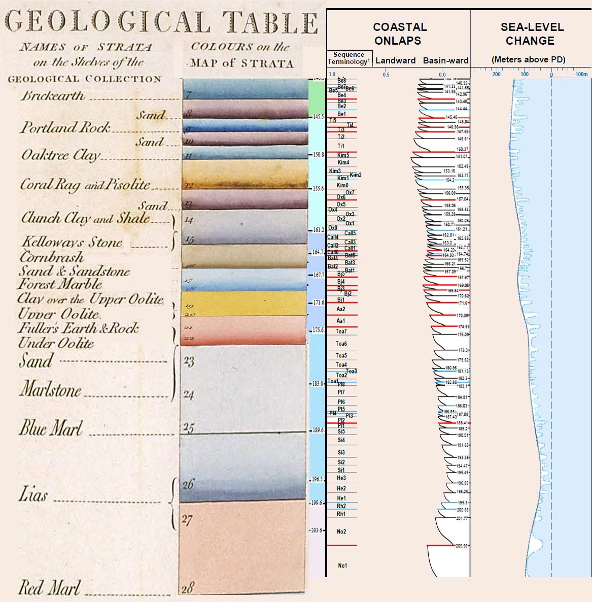
Smith's cross section of England is one complete one, the entire column all laid down and then tilted. If you're trying to say that Smith drew a stratigraphic column for England where the full geologic column was represented, then that would be wrong. Are you thinking of something like this? This particular image puts Smith's stratigraphic column on the left and modern data on the right. It only seems to go back as far as the Jurassic:
I know you explain all this differently but to me it's all evidence... You haven't described any evidence - not any. None. Zilch. Nada. Zero. Diddly-squat. Zippo. Why are you claiming now that you've described evidence when in other very recent posts from the past few days you've conceded that you have no evidence while hoping it will be found soon.
...that the geo column couldn't possibly be explained by time periods of millions of years..... But anyway.... Are you perhaps trying to say that you've presenting some reasoning for why the geologic column can't be millions of years old? I could understand you thinking that more than I could understand how you think you've presented any evidence. But while you have managed to say some things that are true, they don't argue against the geologic column, they don't seem to support a young Earth, and they don't seem to support a global flood 4500 years that was responsible for all the world's geology that we see today. --Percy
|
|||||||||||||||||||||||||||||||||||||||
|
edge Member (Idle past 1734 days) Posts: 4696 From: Colorado, USA Joined: |
What about salt flats, like in Utah?
Heh, heh ... I've heard that the maximum depth of the Great Salt Lake is 30 feet. I guess Faith never heard of playa lakes.
The average depth of Hudson Bay is only about 100 meters. And I wonder where Faith thinks all of those perfectly flat areas of the midwest (US) came from. Edited by edge, : No reason given.
|
|||||||||||||||||||||||||||||||||||||||
|
|
Do Nothing Button
Copyright 2001-2023 by EvC Forum, All Rights Reserved
![]() ™ Version 4.2
™ Version 4.2
Innovative software from Qwixotic © 2024