|

Understanding through Discussion |
|
|
Register | Sign In |
|
QuickSearch
| Thread ▼ Details |
|
Suspended Member (Idle past 1474 days)  Posts: 35298 From: Nevada, USA Joined: |
|
Thread Info
|
|
|
| Author | Topic: Evidence that the Great Unconformity did not Form Before the Strata above it | |||||||||||||||||||||||||||||||||||||||||||||||||
Faith  Suspended Member (Idle past 1474 days) Posts: 35298 From: Nevada, USA Joined: |
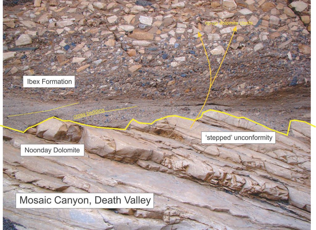
He says the [abe; stepped ends of the /abe] rock (dolomite) shows no weathering from a smooth surface.
Yes, there is no evidence that the unconformity surface was ever flat. If you think it was flat, please tell us why. I don't have any clear idea what I'm looking at so I have no opinion about whether what you call the unconformity surface was ever flat.
I have no idea how one could tell that from this photo.
Partly because there is no disruption of the upper beds and because there is no abrasion or dissolution at the contact. My problem is that I don't see any "upper beds," I see a flat ground-level surface of sand with an upright sort of wall behind it. So I don't see any contact let alone abrasion or dissolution. I need to see this from another angle, or as HBD suggested, without the yellow outline.
To my eye it shows a lot of weathering on any surface you look at, surface-schmurface.
Please explain what this weathering looks like. There is no smooth surface on any side of the lengths of rock, they look to be gouged and misshapen on all surfaces.
If it was once strata surely it was originally laid down in flat horizontal layers of the sort we see in the strata. How do you get from that to these desiccated irregular lumps of stone without its having undergone trauma of some sort, possibly including weathering?
Of course they were weathered, that would be the nature of an erosional unconformity. They were likely laid down as normal sediments, lithified, tilted and then eroded. On all surfaces?
And how could anyone possibly tell whether the stepped ends were the surface of an unconformity?
What else would they be? Broken lengths of strata much battered on all surfaces.
And no matter how I peer at it I can't see the cross-bedded sandstone as "overlying" the stepped ends of the dolomite.
I'm sure you don't see it. But that's irrelevant. Why would there be cross bedding? I can't assume it's the upper part of an unconformity based on this picture so I can't even speculate about your question.
Please explain. Perhaps another angle on the same formation would help?
No, it probably wouldn't help. This is what you get. You can deny all you want, but most people see something different. How are you going to make your point by just saying, "I don't see it"? Now, why don't you answer my question? If I can't see what you say is there I can't possibly answer your question. So if this is all I get I suppose it will simply remain a mystery. Edited by Faith, : No reason given.
|
|||||||||||||||||||||||||||||||||||||||||||||||||
|
edge Member (Idle past 1736 days)  Posts: 4696 From: Colorado, USA Joined: |
I don't have any clear idea what I'm looking at so I have no opinion about whether what you call the unconformity surface was ever flat.
If it were flat, I'd like to hear how it got to be its current shape.
My problem is that I don't see any "upper beds," ...
This seems to be your main argument for this entire thread. You 'don't see it'.
I see a flat ground-level surface of sand with an upright sort of wall behind it.
Here we are again. You don't understand the viewpoint of the image. It is of a wall. It is not like looking at a map.
So I don't see any contact let alone abrasion or dissolution.
I see several contacts, but no I don't see any evidence for abrasion or dissolution. So, are you abandoning your scenario for unconformity formation?
I need to see this from another angle, or as HBD suggested, without the yellow outline.
My guess is that you would never have enough pictures to satisfy you.
There is no smooth surface on any side of the lengths of rock, they look to be gouged and misshapen on all surfaces.
Those are normal intersections of bedding with fractures. Why do you say there is a 'lot of weathering'? Is the rock weathered to clay? Are there solution cavities? Is that a paleosoil? Is the iron-oxide coating heavy?
On all surfaces?
Why not? There are fractures and bedding planes that you have noticed.
Broken lengths of strata much battered on all surfaces.
Yes, erosion would break off fragments of the rocks. What do you mean by 'battered', do you see scratches, gouges, voids?
I can't assume it's the upper part of an unconformity based on this picture so I can't even speculate about your question.
Right. You 'cant see it'. So, there is no need to explain anything that everyone else sees.
If I can't see what you say is there I can't possibly answer your question.
That is convenient for you.
So if this is all I get I suppose it will simply remain a mystery.
You seem to have a lot of mysteries.
|
|||||||||||||||||||||||||||||||||||||||||||||||||
|
Faith Suspended Member (Idle past 1474 days) Posts: 35298 From: Nevada, USA Joined: |
The sand looks from this angle to be completely unrelated to the "stepped unconformity"
How could they be "completely unrelated?" when they are touching each other? It's probably an optical illusion created by the angle of the photograph but I absolutely cannot see the sand as anything but background, completely unrelated to the stone formation which seems to be lying on top of it. completely unrelated, not touching each other at all --- on the unconformity surface I mean -- certainly if the rock is lying on the sand there is contact but not contact at the unconformity surface.
It is kind of hard to see the contact line with his yellow line in there (maybe he could post the unedited version?) but it does seem clear that those two sediments are not conformable. It makes no sense to say they are "unrelated." I can't seem to get them to look like anything but stone lying on sand. If they really do make up an angular unconformity I simply can't see it. Yes, seeing the original might make a big difference.
And how could anyone possibly tell whether the stepped ends were the surface of an unconformity?
Because the two materials that make up the two strata contact each other unconformably. What you are apparently seeing I simply am not, and I can't get it to look the way you are seeing it, the way one can with an optical illusion.
If it was once strata surely it was originally laid down in flat horizontal layers of the sort we see in the strata.
Another very confusing comment. Of course they are strata... I suppose they must be but they look more like battered pillars of stone, well, except for those in the foreground that look more like strata. Yes I know it's strange that I have this strong impression when clearly it looks so different to you, but I'm stuck with it.
Can you distinguish those two sediments from each other? Sure, but they don't appear to be on the same plane.
How do you get from that to these desiccated irregular lumps of stone without its having undergone trauma of some sort, possibly including weathering?
"possibly including weathering" ??? Of course it has been weathered. I can't for the life of me figure out why you would say this? Yes, it possibly includes a LOT of weathering. Kind of looks like somebody battered them with a sledge hammer.
And how could anyone possibly tell whether the stepped ends were the surface of an unconformity?
Because the two strata contact each other unconformably. Can't see any contact. Maybe it will suddenly snap into the right perspective eventually.
What is the exact nature of the unconformity? That is not so clear from the picture, but it is an unconformity - by definition. I'll take your word for it but I can't see it.
The point of the "rip-up" portion is that it is comprised of material that was derived from the dolomite (the larger clasts) and at least one other material of which the source is not in the picture along with fine sand and gravel. This looks to me like a mass-wasting or possibly scree at the base of a cliff. A broader picture would be helpful, though. Yes, an angle that shows more of the context or environment would help. ABE: The picture again, for reference:
Edited by Faith, : No reason given. Edited by Faith, : No reason given. Edited by Faith, : No reason given. Edited by Faith, : No reason given. Edited by Faith, : No reason given.
|
|||||||||||||||||||||||||||||||||||||||||||||||||
|
edge Member (Idle past 1736 days) Posts: 4696 From: Colorado, USA Joined: |
It's probably an optical illusion created by the angle of the photograph but I absolutely cannot see the sand as anything but background, completely unrelated to the stone formation which seems to be lying on top of it. completely unrelated, not touching each other at all. I can't seem to get them to look like anything but stone lying on sand. If they really do make up an angular unconformity I simply can't see it. Yes, seeing the original might make a big difference.
What you are apparently seeing I simply am not, and I can't get it to look the way you are seeing it the way you can with an optical illusion. Sure, but they don't appear to be on the same plane. Kind of looks like somebody battered them with a sledge hammer.
Can't see any contact. Maybe it will suddenly snap into the right perspective eventually. I'll take your word for it but I can't see it.(bold added) It looks like we have a visualization problem here. Perhaps you cannot perceive the third dimension in most of the photographs that we have provided you. We seem to have this problem over and over where you see something completely different. You might just have to trust us on this.
Yes, an angle that shows more of the context or environment would help.
There is no other viewpoint available. Here is the original:
I know you are going to have problems seeing this, but the top of the image is up if that helps. The bedding planes in the lower dolomite rocks tilt moderately to the right and the fragmental stratum in the upper part of the picture is actually a solid rock.
|
|||||||||||||||||||||||||||||||||||||||||||||||||
|
Faith Suspended Member (Idle past 1474 days) Posts: 35298 From: Nevada, USA Joined: |
Thanks for putting up the original. Now I see the dolomite as embedded in the sand. At least there's contact with the stepped surface now. But I'm going to have to come back to this later, or tomorrow.
|
|||||||||||||||||||||||||||||||||||||||||||||||||
|
Admin Director  Posts: 13046 From: EvC Forum Joined: Member Rating: 2.6 |
Faith writes: I need to see this from another angle, or as HBD suggested, without the yellow outline. HBD made the same request. I was able to find this:
|
|||||||||||||||||||||||||||||||||||||||||||||||||
|
Admin Director Posts: 13046 From: EvC Forum Joined: Member Rating: 2.6 |
Reposting images into your message is extremely helpful. It makes no difference that the image has been posted a dozen times already, it is really helpful to have it right there in your message. It is even more helpful to annotate the image if you're calling attention to a specific part. When annotating, if it wouldn't be too ambiguous you might consider using circles, ovals, boxes and so forth instead of lines to identify boundaries, because at least in this particular discussion obscuring the boundary seems to raise doubts in the minds of some of what they're actually seeing.
|
|||||||||||||||||||||||||||||||||||||||||||||||||
|
RAZD Member (Idle past 1435 days)  Posts: 20714 From: the other end of the sidewalk Joined: |
One important point in what you are discussing is "sea level changes", not a series of waves or a flood but rather long term transgression and regression events separated by relatively static periods. Indeed, because the mechanism of Walther's Law is the different settling rates of different sediments by their sizes and densities, which gets back to Stokes' Law. When we look at the graphic for Walther's Law provided by Percy in Message 9 of the Depositional Models of Sea Transgressions/Regressions - Walther's Law thread:
We can readily see that these different layers are predominantly sorted by their settling rates (based on size and density). We can also see that the Sands and Siliciclastic Muds are products of erosion that are necessarily products of the adjacent lands being eroded there and deposited here, rather than being transported from some distant transoceanic location. Then we refer to Message 50 of Dr A's excellent geology thread Introduction To Geology we can see that one element of the the Carbonate Sediments would be produced by the erosion of limestones exposed in the adjacent eroding landscape -- a chemical process that dissolves the Calcium Carbonate in fresh water which then precipitates in salt water when transported to the oceans. However, other more dominant components of this Carbonate Sediments layer are the shells and detritus from inter-tidal, reef and other littoral zone organisms growing in situ (within the zone that sunlightpenetrates). And then we have the last layer group, Coccolith Foram Ooze, which is formed from Biochemical sediment from the shells of diatoms, foraminifers, etc., in the Epipelagic and Mesopelagic zones of the open ocean (again the zones where sunlight penetrates). This gives us the horizontal distribution above
We can also see that there should be some interbedding of the marine life detritus with the Sands and Siliciclastic Muds layers, and that only when the horizontal reach of Siliciclastic Muds is reached would you find marine life growing on top of the previous generations of marine life in a distinct layer. Now I find it rather difficult to envisage a system of waves orbiting a flooded globe that could duplicate these deposition conditions and environments, but perhaps Faith can explain these details from her armchair of profound knowledge .... Enjoyby our ability to understand Rebel☮American☆Zen☯Deist ... to learn ... to think ... to live ... to laugh ... to share. Join the effort to solve medical problems, AIDS/HIV, Cancer and more with Team EvC! (click)
|
|||||||||||||||||||||||||||||||||||||||||||||||||
|
RAZD Member (Idle past 1435 days) Posts: 20714 From: the other end of the sidewalk Joined:
|
And I'm also talking about a long term transgression and regression and certainly not "waves," only I think the model covers the Flood timing of one months-long transgression followed by a couple months at its maximum height, followed by a months-long regression. There's no reason the principle wouldn't apply to this model. So (a) how do you generate these periods (where does the water go)? Are there now towers of water slowly moving around the planet ??? And (b) how do you explain the life that grows over periods of years in just a couple months? .... Enjoyby our ability to understand Rebel☮American☆Zen☯Deist ... to learn ... to think ... to live ... to laugh ... to share. Join the effort to solve medical problems, AIDS/HIV, Cancer and more with Team EvC! (click)
|
|||||||||||||||||||||||||||||||||||||||||||||||||
|
Faith Suspended Member (Idle past 1474 days) Posts: 35298 From: Nevada, USA Joined: |
It looks like we have a visualization problem here. Perhaps you cannot perceive the third dimension in most of the photographs that we have provided you. We seem to have this problem over and over where you see something completely different. I think this particular photo is a problem because there is no indication of where the top and bottom are, no environment, just the formation. If anything I think I'm seeing a third dimension that isn't there. That's probably just a darker color at the bottom of the ibex formation but it looks like a shadow and that makes it look perpendicular to the sand beneath it rather than on the same plane. But at least now that the outline has been removed, the dolomite doesn't look like it's separated from the sandstone, now it looks like it's embedded in it. Anyway I can now at least surmise the unconformity. Edited by Faith, : No reason given. Edited by Faith, : No reason given.
|
|||||||||||||||||||||||||||||||||||||||||||||||||
|
Faith Suspended Member (Idle past 1474 days) Posts: 35298 From: Nevada, USA Joined: |
Now I find it rather difficult to envisage a system of waves orbiting a flooded globe that could duplicate these deposition conditions and environments, but perhaps Faith can explain these details from her armchair of profound knowledge ....
As I said, with Walther's Law I'm not thinking of waves, just the changes in sea level, which is probably quite enough to explain the whole Flood scenario. Waves may not play a part in the Flood scenario at all, they simply occurred to me as something that would probably happen as the land was reappearing.
|
|||||||||||||||||||||||||||||||||||||||||||||||||
|
Faith Suspended Member (Idle past 1474 days) Posts: 35298 From: Nevada, USA Joined: |
Some creationists have good ideas about where the water went, mostly involving the collapse of the sea floor I think, but that's not part of the Flood scenario I'm up on. In any case we're getting too far off topic in this thread.
Edited by Faith, : No reason given.
|
|||||||||||||||||||||||||||||||||||||||||||||||||
|
RAZD Member (Idle past 1435 days) Posts: 20714 From: the other end of the sidewalk Joined: |
... In any case we're getting too far off topic in this thread. Agreed. We can get back to this some other time. Enjoyby our ability to understand Rebel☮American☆Zen☯Deist ... to learn ... to think ... to live ... to laugh ... to share. Join the effort to solve medical problems, AIDS/HIV, Cancer and more with Team EvC! (click)
|
|||||||||||||||||||||||||||||||||||||||||||||||||
|
Admin Director Posts: 13046 From: EvC Forum Joined: Member Rating: 2.6
|
Faith writes: I think this particular photo is a problem because there is no indication of where the top and bottom are,... This is the photo:
This image is from a different part of Mosaic Canyon, but it provides a rough idea of the context. The sand with the embedded rocks was deposited atop the light-colored dolomite:
It might be helpful to clarify this portion:
But at least now that the outline has been removed, the dolomite doesn't look like it's separated from the sandstone, now it looks like it's embedded in it. It isn't clear what you're implying when you say you previously thought the dolomite and sandstone layers were separated. Why do you think it possible for rock layers to be separated (I assume you mean by air - of course rock layers can be separated by other rock layers), what do you think that implies about the angular unconformity, and what do you think the absence of a separation implies?
|
|||||||||||||||||||||||||||||||||||||||||||||||||
|
herebedragons Member (Idle past 887 days)  Posts: 1517 From: Michigan Joined:
|
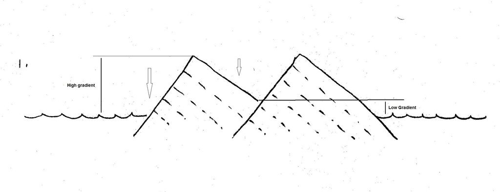
I wanted to offer you this explanation about how an uplifted, jagged landscape can be reduced to a level surface. What this does is illustrate what jar has been saying about how material is moved from high places to low places. It is overly simplistic but should give you the idea behind how erosion could work over time to wear down a landscape.
This first photo shows uplifted tilted blocks with a valley in between them - very much like what we see with the Supergroup. I have drawn it as an island to keep it as simple as possible. One thing to keep in mind is that we should be talking about energy gradients here; erosion moves material from high energy potential to low energy potential. The water level indicates lowest energy potential, the mountain peaks indicate high energy potential and the valley indicates low energy potential.
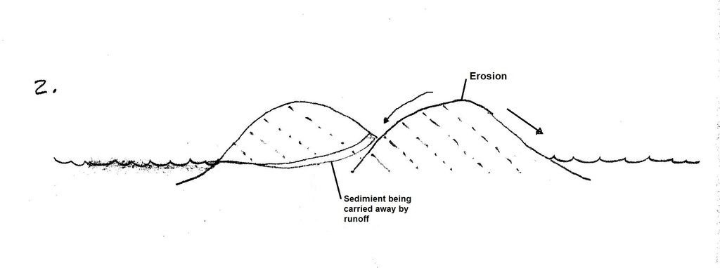
Image 2 shows how erosion has worked to round off the sharp peaks. Because there is still an energy gradient from the valley to the water level, sediment coming from the peaks will be carried away from the valley through runoff. (A good contemporary example of this is the Adirondacks as compared to the Rocky Mountains. The Rockies have sharp jagged peaks while the Adirondacks’ peaks have been rounded off by erosion)
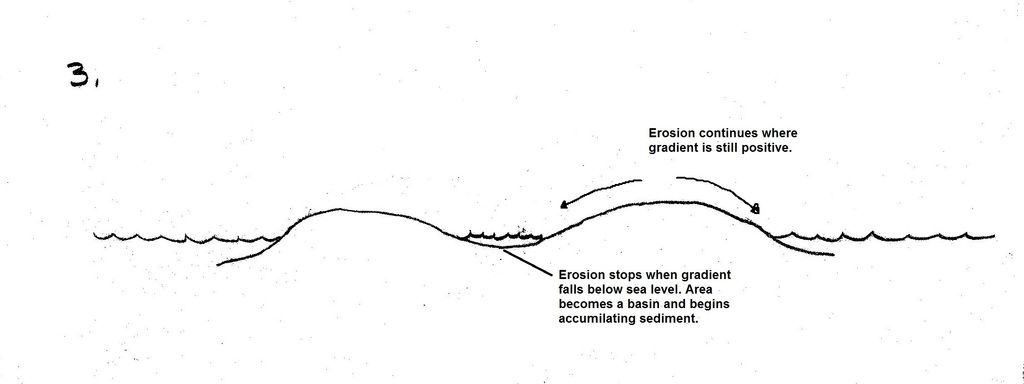
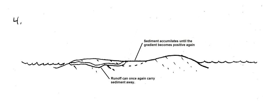
Image 3. When the valley has worn down to the point that there is no longer a sufficient energy gradient to carry sediment away, it begins filling with sediment. Erosion continues at the places where there is still a high enough energy gradient to carry material away.
Image 4. When enough sediment accumulates in the basin, the energy gradient increases until sediment can once again be carried away. Sedimentation stops and the valley once again becomes an area of net erosion. The process repeats between image 3 and 4 as energy gradients shift back and forth and the area shifts between net deposition and net erosion.
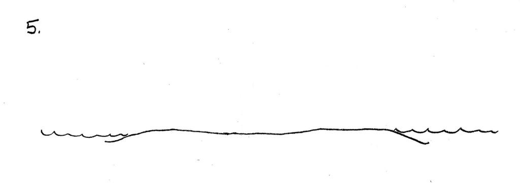
In the end, there is nothing that CAN happen BUT a flat plain created. Eventually, this water will come up onto the land and will further level the landscape by eroding the highs and filling the lows.
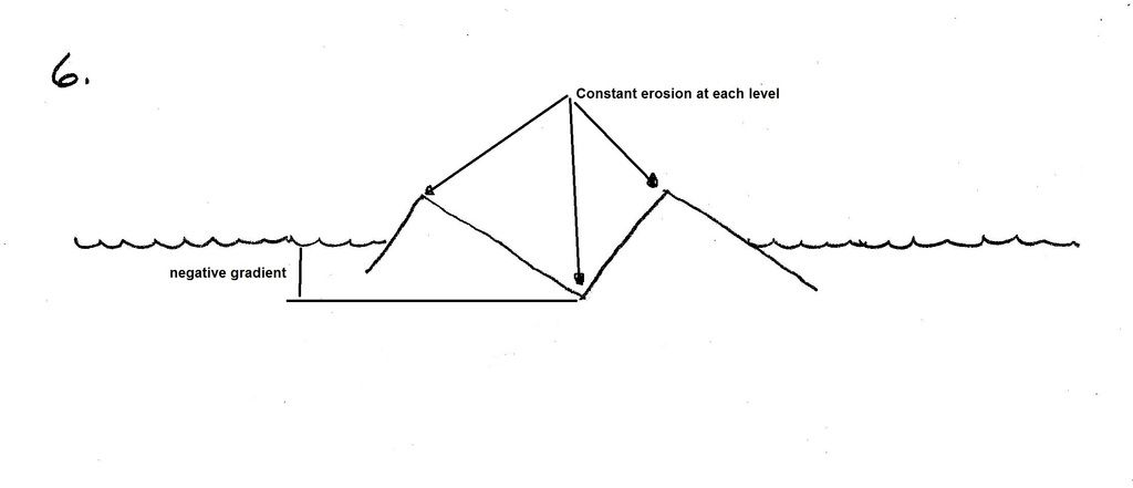
Image 6 illustrates what would happen if there was continuous and equal erosion on all surfaces. It could not happen this way. A negative energy gradient would be created in the valley and there would be nowhere for erosion products to go. They would HAVE to accumulate - which would take it back to image 3 Your images of erosion in Message 345 show what happens when water runs off the surface rapidly and in high volumes, not what happens with normal, long-term erosional processes. (commentary: If a world-wide flood did shape what is now the surface of the earth, this is the type of erosion we should see everywhere. But it’s not instead we see evidence of these slow, long term processes). I think this post illustrates the model as to how rugged landscapes can be worn down to flat plains. It is more than just fantasy, it is based on real, physical processes and principals that we observe. Is this what happened to the surface of the Grate Unconformity? Maybe, maybe not This post is not meant to address that particular question, but to give a model for landscapes being reduced to a flat plain. I realize my model is overly simplistic, but it is the principles you should focus on. The ONLY thing that erosion CAN do is reduce a lumpy, bumpy landscape into a flat plain - because erosion does not act alone but in conjunction with deposition. HBD Edited by herebedragons, : typoWhoever calls me ignorant shares my own opinion. Sorrowfully and tacitly I recognize my ignorance, when I consider how much I lack of what my mind in its craving for knowledge is sighing for... I console myself with the consideration that this belongs to our common nature. - Francesco Petrarca "Nothing is easier than to persuade people who want to be persuaded and already believe." - another Petrarca gem. Ignorance is a most formidable opponent rivaled only by arrogance; but when the two join forces, one is all but invincible.
|
|||||||||||||||||||||||||||||||||||||||||||||||||
|
|
Do Nothing Button
Copyright 2001-2023 by EvC Forum, All Rights Reserved
![]() ™ Version 4.2
™ Version 4.2
Innovative software from Qwixotic © 2024